Columbus County is much easier to understand when Whiteville is used as a starting point rather than treated as the whole county. Lake Waccamaw gives the eastern half a strong natural landmark, Tabor City anchors the southwest near the South Carolina line, and Fair Bluff sits on the western side near the Lumber River. The maps on this page separate those relationships into a road-and-boundary view, a simplified city distribution view, and a terrain-and-water view. After reviewing the maps, visitors can download the matching high-resolution JPG files together in one ZIP archive.
The road map makes the east-west structure especially clear. US 74 and US 76 pass through the Whiteville area and continue toward Lake Waccamaw and Bolton, while Chadbourn and Cerro Gordo sit to the west. Tabor City is not on that same central line; it is well to the southwest, close to the long state boundary. That separation matters because a Whiteville-centered mental picture can make Columbus County look more compact than it really is. In practice, the county stretches across several distinct settlement and water references.
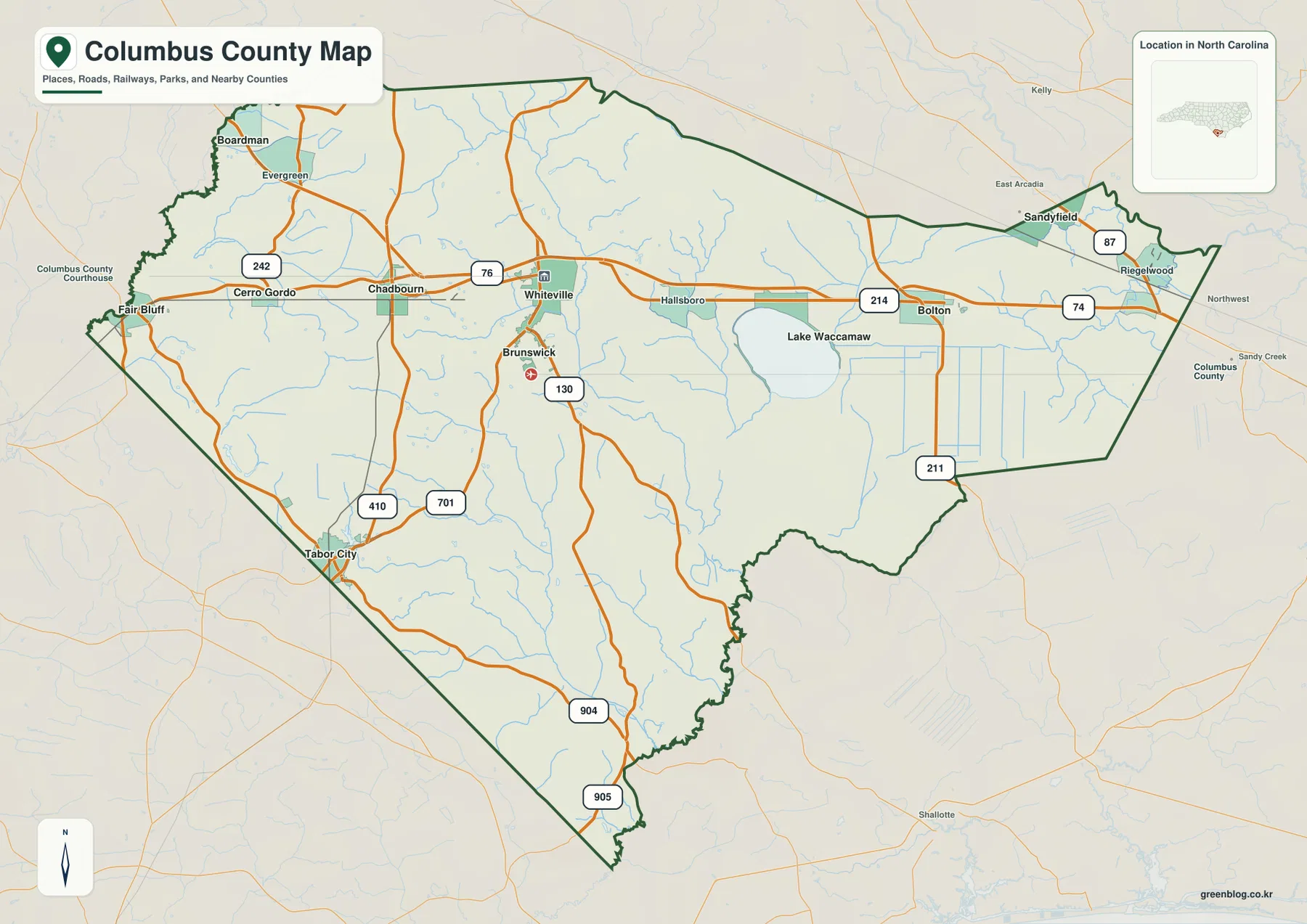
Water is equally important for orientation. Lake Waccamaw is the most prominent named water body inside the eastern half, and the Waccamaw River continues south from the lake area. The Lumber River is visible near the western boundary, while White Marsh, Porter Swamp, Beaverdam Swamp, Grissett Swamp, and other smaller waterways fill in the broad rural interior. No separate elevation map is supplied with this package, so the shaded relief on the water map should be used only to understand the general shape of the land, not to assign precise elevations.
Table of Contents
Whiteville and US 74 organize the central road picture
Whiteville appears near the center of the county’s developed road network, but the map shows several separate directions radiating away from it. West of Whiteville, US 74 and US 76 lead toward Chadbourn, with Cerro Gordo and Fair Bluff farther toward the western side. Eastward, the same broad corridor points toward Hallsboro, Lake Waccamaw, and Bolton. This makes the Whiteville area a practical reference for reading the map, yet it also shows why the county cannot be described as a single compact urban center. Important communities remain widely spaced along the county’s long east-west span.
The southwest has its own road logic. Tabor City lies close to the state line and is connected with US 701 and NC 410, while NC 904 and NC 905 extend through the southern part of the county. Brunswick appears south of Whiteville near NC 130. These routes do not form the same simple east-west pattern seen around Whiteville, Chadbourn, and Lake Waccamaw. A reader trying to locate Tabor City should therefore begin with the southwest corner and the state boundary, then follow the northbound roads toward Chadbourn and Whiteville rather than assuming Tabor City sits directly on the central US 74 corridor.
The eastern side becomes narrower and more irregular. NC 214 appears near Bolton, NC 211 runs through the southeastern part, and NC 87 is marked near the Sandyfield and Riegelwood side. The map also places Robeson County to the west, Bladen County to the north, and Brunswick and Pender Counties on the eastern side for orientation. Those outside labels are useful when a trip or research task continues beyond Columbus County because they show which edge of the county leads toward each neighboring area without turning the map into a detailed navigation product.
Lake Waccamaw and the Waccamaw River define the eastern water reference
The terrain and water map gives Lake Waccamaw a very different role from the towns on the road map. The lake occupies a large, easily recognized shape in the eastern half of Columbus County, and the Waccamaw River continues south from the lake area toward the lower county boundary. White Marsh and Richardsons Millpond are labeled to the west of the lake. Together, these features explain why the space between Whiteville and Lake Waccamaw should not be thought of as an empty gap: it contains a network of streams, marshes, and low-relief water features that become much more visible once the road labels are removed.
The western side uses a different natural landmark. The Lumber River runs near the county’s west edge and provides a useful reference for the Fair Bluff side. Porter Swamp and Beaverdam Swamp appear farther inside the county, while the Tabor City area is accompanied by Lake Tabor and Grissett Swamp. Seven Creeks is labeled farther south. These names make the southwest easier to distinguish from the lake-centered east and show that Columbus County’s waterways are not concentrated around one major river or lake.
In the narrow northeastern portion, Waymans Creek and Livingston Creek are labeled, and the Cape Fear River appears just beyond the county edge as a regional reference. The shaded background is gentle compared with a mountain relief map, which fits the broad, low-relief appearance of the supplied image. However, there are no contour lines or elevation numbers here. The map should therefore be used to compare the relative position of lakes, rivers, creeks, swamps, and general terrain texture, not for flood-zone decisions, parcel boundaries, boating navigation, engineering measurements, or survey work.
The city map separates the central, southwest, and northeast settlement points
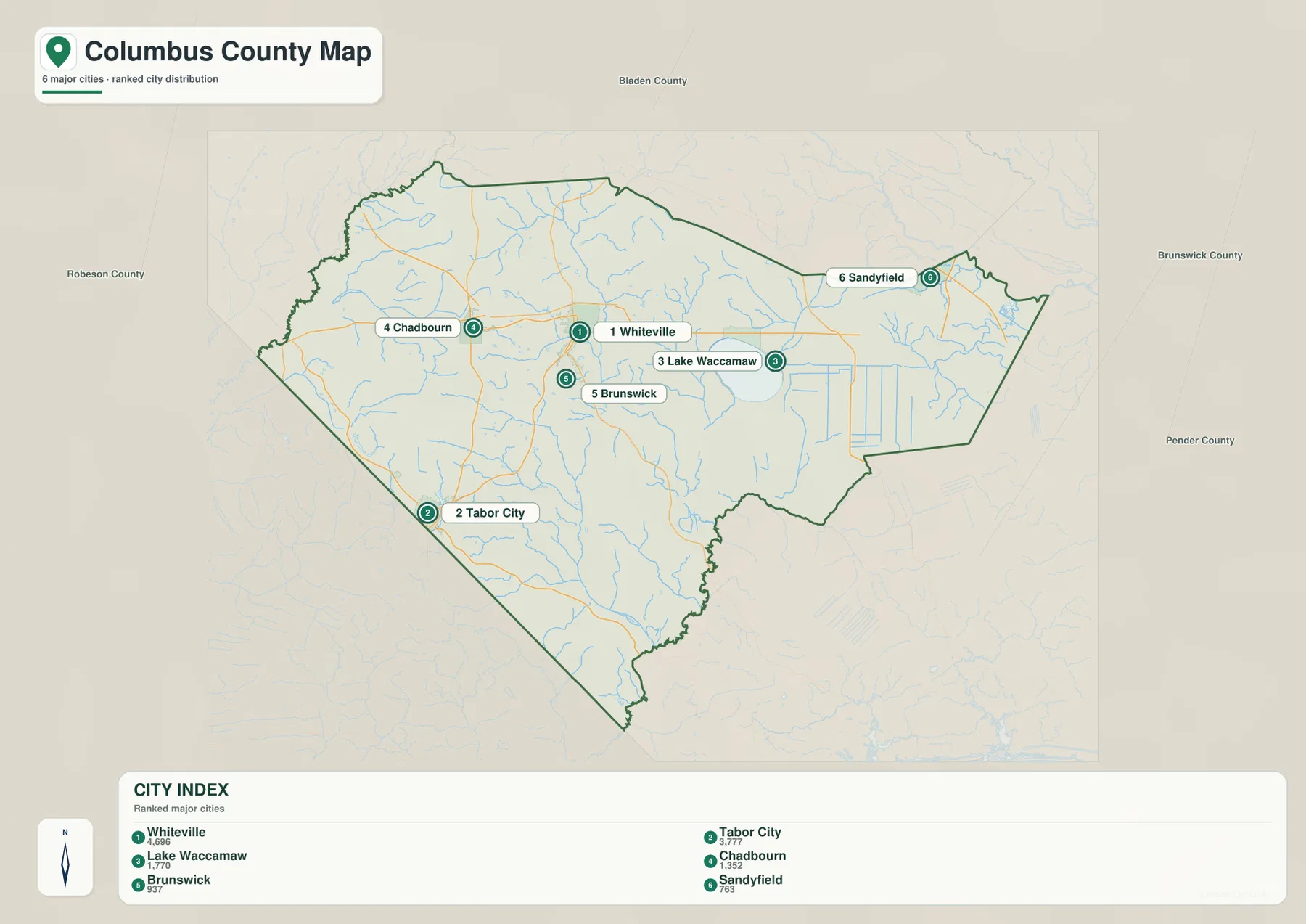
The city map strips away many of the smaller labels and highlights six places with ranked values printed directly on the supplied image. Whiteville is shown at 4,696, Tabor City at 3,777, Lake Waccamaw at 1,770, Chadbourn at 1,352, Brunswick at 937, and Sandyfield at 763. These figures are best treated as the values used by this specific map rather than as a current population database. Their purpose here is to make the relative scale and geographic distribution of the six labeled places easier to compare.
The arrangement is more informative than the ranking alone. Whiteville occupies the interior center, Chadbourn lies to its west, and Lake Waccamaw is to the east. Tabor City is clearly separated in the southwest near the state line. Brunswick sits just south of Whiteville, while Sandyfield is far to the northeast. This creates a useful set of anchors across a large county: central Whiteville, southwestern Tabor City, eastern Lake Waccamaw, and northeastern Sandyfield. A visitor who knows only one of those names can use the others to establish direction before moving to a more detailed road or address map.
Comparing the city map with the fuller county map adds another layer. Whiteville, Chadbourn, and Lake Waccamaw roughly follow the main east-west road corridor, but Tabor City falls well south of it. Sandyfield is also separated from the central corridor and occupies the narrowing northeastern side. That contrast is useful when planning how to read the county: the road map is best for the network between communities, while the city map quickly tells you which broad section of the county a named place belongs to.
Frequently Asked Questions
What local geographic pattern becomes clearer around Lake Waccamaw?
Lake Waccamaw represents part of the county’s physical framework; Whiteville, Tabor City, and Fair Bluff represent settlement. The two layers should remain distinct so urban or administrative importance does not erase terrain or water context.
What additional local context does Tabor City provide?
Tabor City extends the map beyond a seat-centered description. It provides another settlement anchor for reading areas that would otherwise be represented only through Whiteville.
Which map best shows the relationship between Lake Waccamaw and the Waccamaw River?
The terrain and water map is the clearest choice. Lake Waccamaw is shown as the large named water body in the eastern half, and the Waccamaw River continues south from the lake area. White Marsh and Richardsons Millpond are also visible nearby, so the map gives more water context than the road map.
Why does Tabor City need to be read separately from Whiteville on the county map?
Tabor City lies far to the southwest near the South Carolina boundary and is associated with the US 701 and NC 410 side of the road network. Whiteville is farther northeast on the central US 74 and US 76 corridor. Treating them as separate orientation points makes it much easier to understand the long southwest portion of Columbus County.
What files are included in the Columbus County download ZIP?
The archive contains three high-resolution JPG files: the county road-and-boundary map, the simplified city distribution map, and the terrain-and-water map. No separate elevation map is included, so the shaded relief in the water map should not be treated as a precise elevation product.
Map File Information
Download the map files associated with this page for reference, printing, and compatible visual projects.
- Included Files: Use only the versions confirmed in the article and supplied images
- File Type: Use the confirmed download contents
- Intended Use: Printing, education, presentations, and map-based projects
Related Maps
Sources and References
The supplied Columbus County maps and package materials are the primary basis for the descriptions above. The following references provide additional county, boundary, and hydrography context.
Green Map creates custom-edited map images using open geographic data sources such as geoBoundaries, Natural Earth, OpenStreetMap, and government open data.
These maps are edited visual materials, not raw data files, and are provided for education, documents, presentations, and graphic reference.