You can download four high-resolution A3 JPG maps of Liberty County, Texas, in one ZIP directly from this page. The set includes a general county map, a ranked city map, a terrain-and-water map, and an elevation map. Together they show Dayton, Cleveland, Liberty, Plum Grove, Ames, Daisetta, major numbered roads, the Trinity River and several named waterways and lakes, plus an actual elevation range of about -2 to 75 meters.
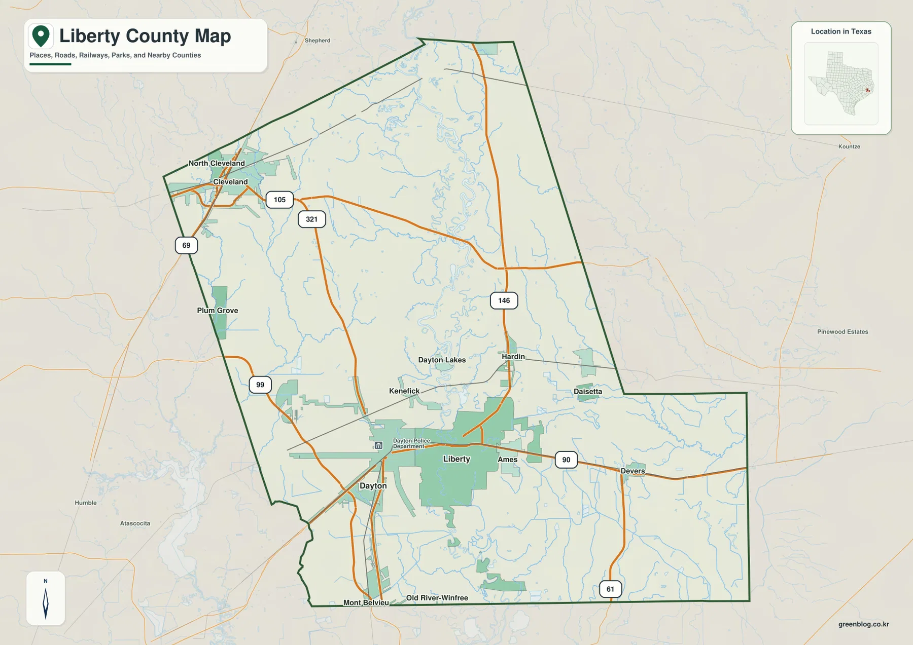
The county is easier to understand when its northern and southern settlement areas are separated. Cleveland and North Cleveland sit near the northwestern corner, where roads marked 69, 105, and 321 are close together. Farther south, Dayton and Liberty form another strong reference area along the road marked 90, with Ames and Devers extending eastward. Between those areas, the Trinity River runs through the middle of the county and becomes the main physical feature on the water and elevation maps.
Table of Contents
Dayton and Liberty anchor the southern settlement pattern
Dayton lies near the southwestern side of the main southern section, while Liberty is east of it near the middle. The road marked 90 continues from Liberty through Ames toward Devers, giving the lower part of the county a clear east-west reference. Additional roads branch north and south around Dayton, so this area contains a noticeable concentration of transport lines compared with some of the more open eastern interior.
Ames is immediately east of Liberty, and Devers is farther east along the same broad road corridor. North of Liberty, Hardin and Daisetta appear relatively close together, with Route 146 running through that part of the county. Kenefick and Dayton Lakes occupy the interior between the southern towns and the Cleveland area, providing useful intermediate place names when reading the county from south to north.
Old River-Winfree and Mont Belvieu are labeled along the southern edge of the map. Their positions help show how far the county extends below the Liberty-Dayton area. The general map is most useful for this combination of settlements and roads, while the water map later on the page gives a much clearer view of the Trinity River and the smaller channels that cross the same southern landscape.
Cleveland occupies a compact road cluster in the northwest
Cleveland and North Cleveland sit very close to the northwestern county boundary. Route 69 runs along the western side of this area, Route 105 extends eastward, and Route 321 heads south from the Cleveland vicinity. The concentration of road lines and settlement shading makes this small corner look much denser than the large central and southeastern sections of the county.
Plum Grove lies farther south along the western side. Route 105 continues east from Cleveland toward the interior, eventually approaching the north-south road marked 146. This creates a useful west-to-east line across the northern half, while Route 321 provides a separate connection toward the central-southern part of the county.
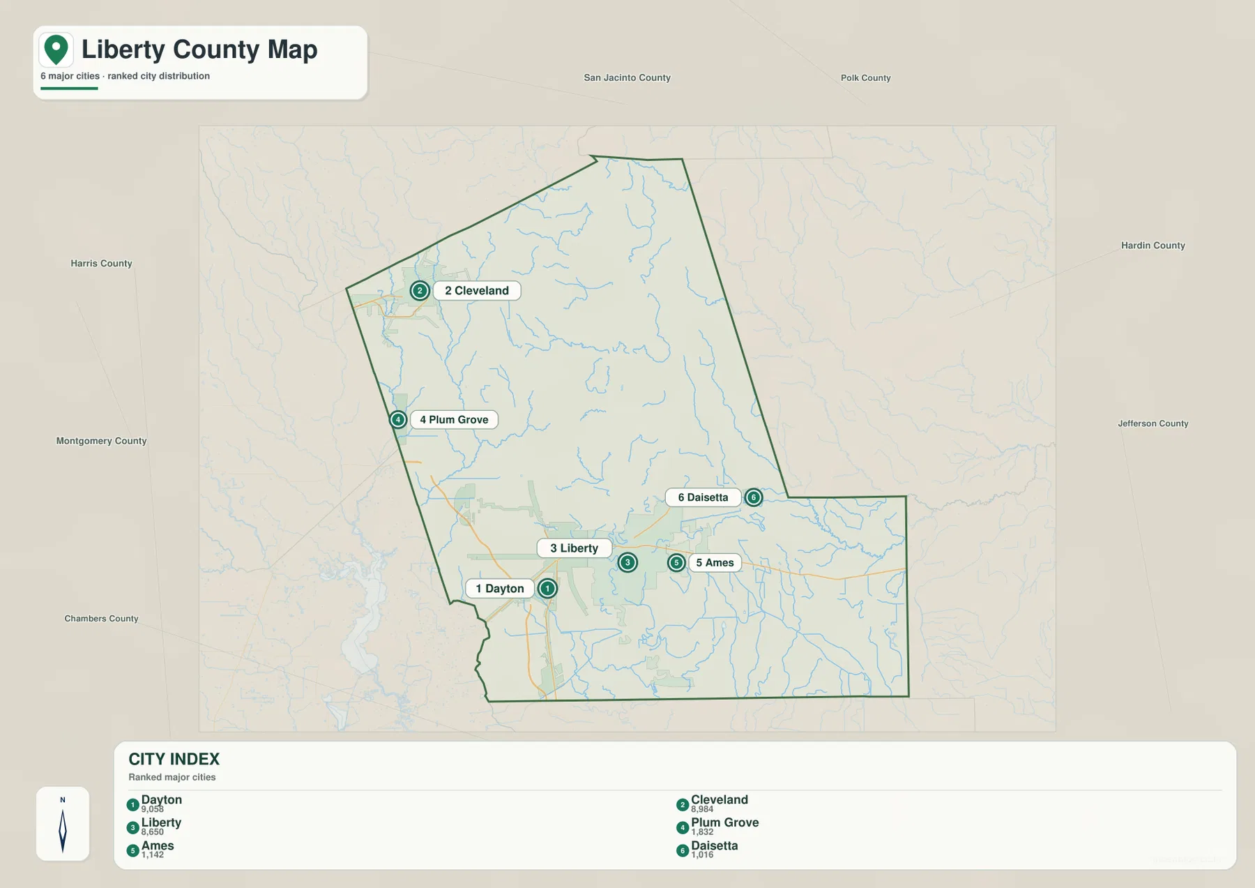
The ranked city map reinforces the same pattern without the road detail. Cleveland is listed second among the six major cities, and Plum Grove is fourth. Their positions near the western side contrast with Dayton, Liberty, and Ames farther south, and with Daisetta on the eastern side of the central section.
The city index shows six major communities spread from northwest to southeast
The city map ranks Dayton first, Cleveland second, Liberty third, Plum Grove fourth, Ames fifth, and Daisetta sixth. The rankings provide a compact index, but the locations are more useful for understanding the county’s shape. Dayton, Liberty, and Ames form a southern-central group, while Cleveland and Plum Grove are separated from them along the western side.
Daisetta sits east of the Liberty-Ames area, giving the six-city distribution a broader east-west spread. The simplified map makes these distances more obvious because most of the small roads and place labels have been removed. It is therefore useful for a quick city-location graphic, while the general county map remains the better reference when actual numbered routes or smaller communities are needed.
Harris, Montgomery, San Jacinto, Polk, Hardin, Jefferson, and Chambers counties are labeled around the map for regional orientation. These surrounding names help place Liberty County within southeast Texas. The central task of the city map, however, is to show how the six ranked communities are distributed inside the county boundary.
Trinity River forms the central water corridor
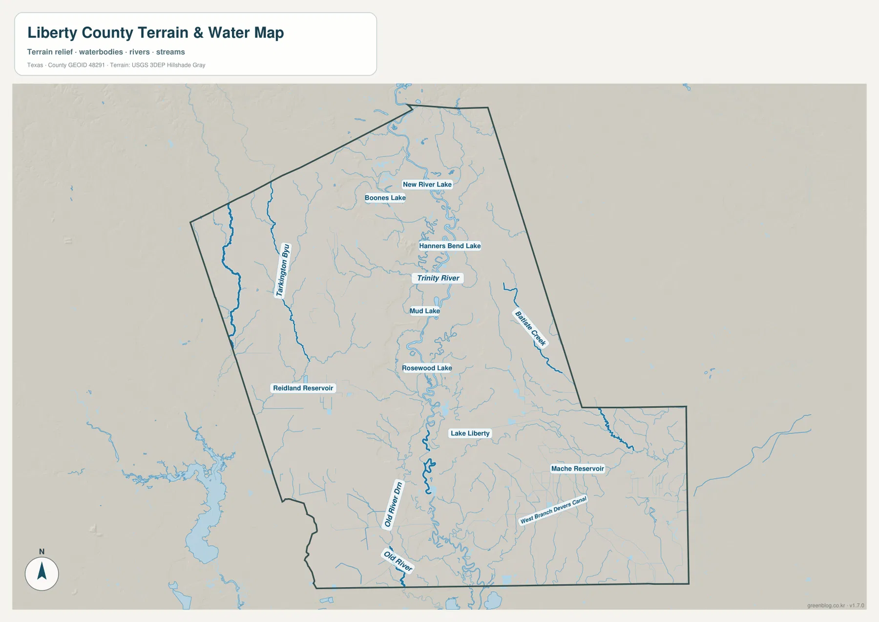
The terrain-and-water map makes the Trinity River the strongest geographic feature in the county. It enters from the north and follows a winding course through the center before continuing south. New River Lake, Hanners Bend Lake, Mud Lake, and Rosewood Lake are labeled close to the river in the northern and central sections, making the floodplain-like corridor visually much more complex than it appears on the road map.
On the western side, Tarkington Bayou runs roughly north-south, with Boones Lake labeled farther north. Reidland Reservoir appears in the west-central area. Farther south, Old River Ditch and Old River form separate named channels west of the Trinity River, adding another layer of water features to the lower county.
Battle Creek is labeled on the eastern side, while Mache Reservoir and West Branch Devers Canal appear in the southeastern section. Lake Liberty sits east of the Trinity River in the central-southern part of the county. These names make it possible to compare the main river with separate bayous, creeks, old channels, canals, lakes, and reservoirs. The map is intended as a geographic water reference, not a flood-hazard, parcel-boundary, legal-water-boundary, or navigation product.
The northwest is higher than the broad Trinity River lowlands
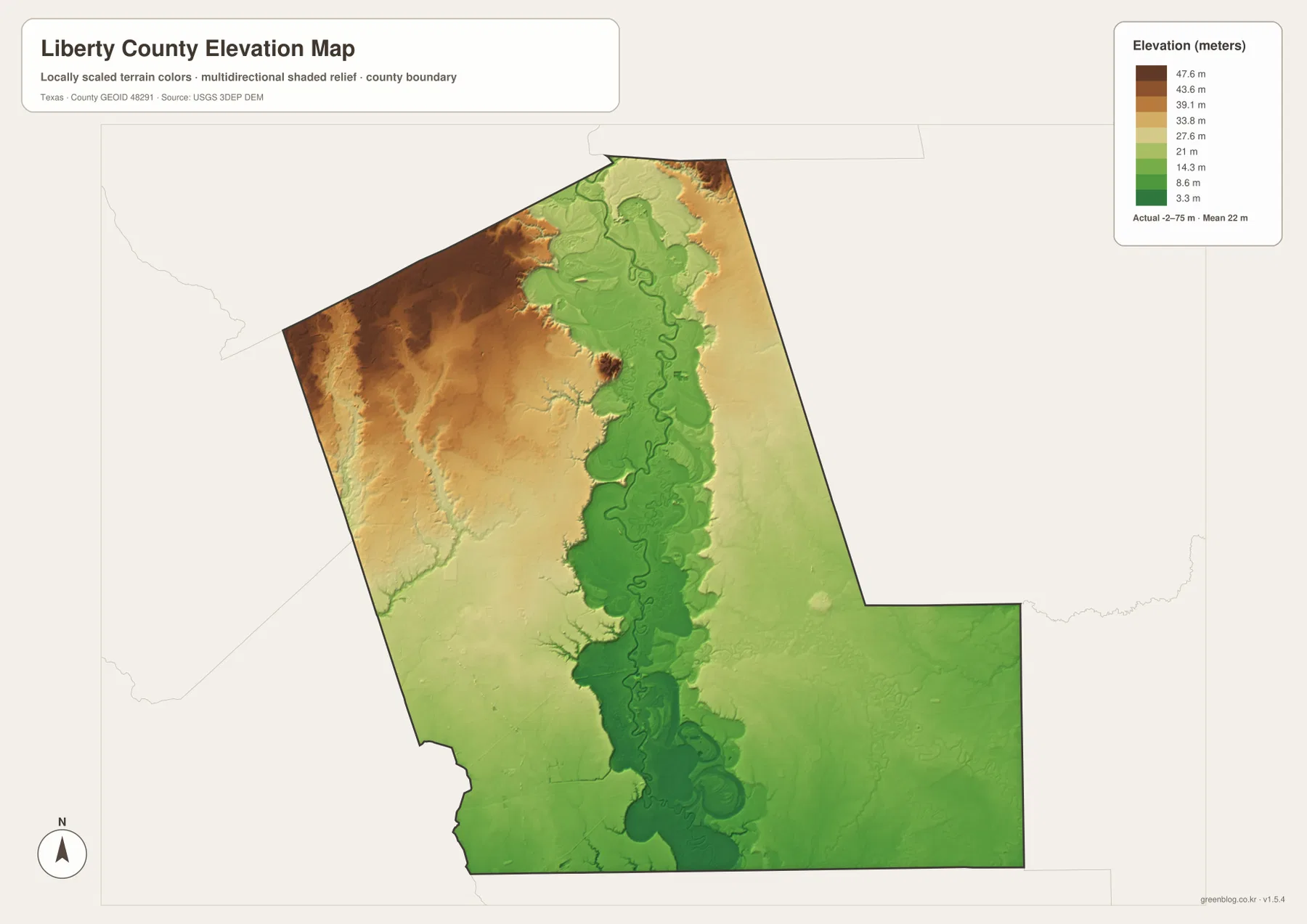
The elevation map reports an actual range of about -2 to 75 meters and a mean elevation of about 22 meters. The darkest brown terrain is concentrated in the northwest and western side, where the county reaches its higher elevations. A broad green corridor follows the Trinity River through the center, and much of the southern and eastern section is also shown in relatively low colors.
The river corridor is unusually easy to trace because the winding channel is surrounded by a wide band of lower terrain. Moving west from the Trinity River generally leads into higher colors, especially toward the Cleveland side. Smaller drainage lines cut narrow lower paths into those western uplands, so the higher terrain is broken by creeks rather than forming one completely flat block.
The displayed difference between the minimum and maximum elevation is about 77 meters. Liberty County is therefore a generally low county, but the northwest-to-river contrast is still clear. This elevation image is best used for comparing relative terrain and drainage corridors; it should not be treated as survey-grade or engineering-grade elevation measurement.
The same location looks different on the road, water, and elevation maps
The Dayton-Liberty area is a good example. The general map shows the main southern road network and the Route 90 corridor. The water map places the Trinity River, Old River, and nearby channels in the same part of the county, while the elevation map shows a broad area of low green terrain. Together, the three views explain why the southern map contains both transport lines and so many water features.
The Cleveland area provides the opposite contrast. Roads 69, 105, and 321 create a dense transport pattern in the northwest, and the elevation map shows that this same corner is among the higher parts of the county. Tarkington Bayou and smaller tributaries cut through the western terrain, so even this higher area contains many drainage lines.
Use the ranked city map when the six main communities are the focus, the general map when roads and additional settlements are needed, the terrain-and-water map for named waterways and lakes, and the elevation map for the northwest-to-Trinity lowland contrast. Smaller labels are often easier to inspect in the downloadable high-resolution JPG files than in the web previews.
Frequently Asked Questions
Which communities are ranked on the Liberty County city map?
The map ranks Dayton first, Cleveland second, Liberty third, Plum Grove fourth, Ames fifth, and Daisetta sixth. Dayton, Liberty, and Ames are grouped in the southern-central area, while Cleveland and Plum Grove are farther west and Daisetta is east of the Liberty area.
Which water features are easiest to identify?
Trinity River is the main central reference. Tarkington Bayou is prominent on the west, Battle Creek on the east, and Old River and Old River Ditch in the south. The supplied map also labels New River Lake, Lake Liberty, Mache Reservoir, and several other lakes and reservoirs.
What elevation range is shown for Liberty County?
The supplied elevation map reports an actual range of about -2 to 75 meters and a mean of about 22 meters. The northwest is relatively high, while the Trinity River corridor and much of the southern and eastern county are lower.
Sources and Reference Data
- U.S. Census Bureau TIGER/Line Shapefiles — official county-boundary and road geometry for geographic reference.
- USGS National Hydrography — official resources for rivers, bayous, creeks, lakes, canals, and other water features.
- USGS 3D Elevation Program — official elevation resources used for terrain information.
- USGS The National Map Viewer — an official viewer for comparing multiple geographic layers.
Map File Information
Download four high-resolution A3 JPG maps of Liberty County, Texas, in one ZIP file.
- Included Files: county map, ranked city map, terrain and water map, elevation map
- File Type: JPG
Related Maps
- Polk County Texas map
- San Jacinto County Texas map
- Orange County Texas map
- Tyler County Texas map
- Waller County Texas map
Green Map creates custom-edited map images using open geographic data sources such as geoBoundaries, Natural Earth, OpenStreetMap, and government open data.
These maps are edited visual materials, not raw data files, and are provided for education, documents, presentations, and graphic reference.