Polk County Texas map|Lake Livingston communities and the Piney Woods

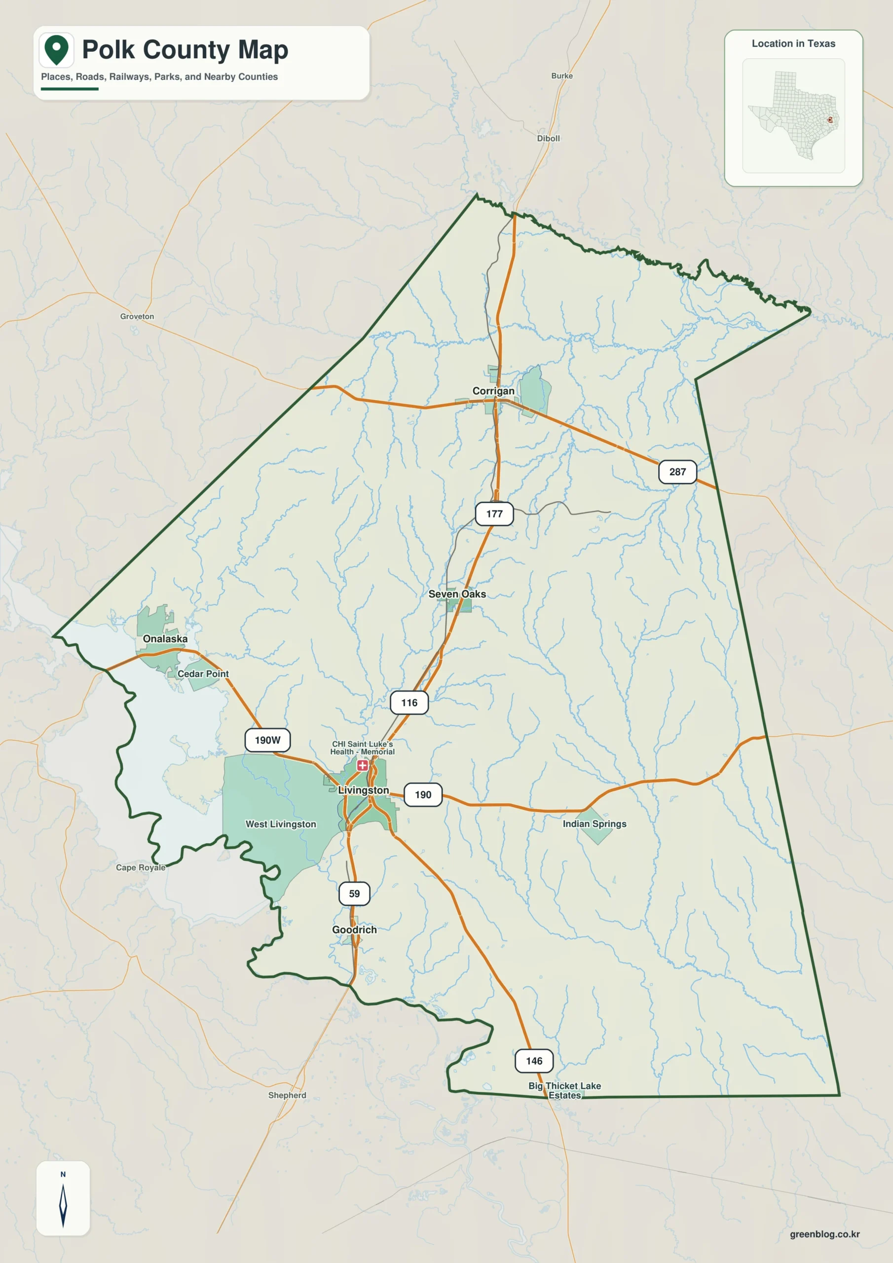
Lakefront neighborhoods, timber towns, tribal lands, and a busy U.S. 59 corridor all fit within Polk County’s broad Piney Woods landscape. This Polk County Texas map separates those local identities by locating Livingston, Corrigan, Onalaska, Goodrich, Seven Oaks, and the large Lake Livingston shoreline within one county frame. The county had an estimated 54,258 residents in 2024 and covers 1,057.05 square miles of land.

Livingston is the county seat and principal service center, but it does not define every part of the county. Onalaska is oriented toward recreation and lake access, Corrigan reflects the northern timber and transportation corridor, and the Alabama-Coushatta Reservation east of Livingston adds a distinct governmental and cultural geography.

  • Continent: North America
  • Country: United States
  • State: Texas
  • County: Polk County
  • Location in State: Deep East Texas, north of Houston
  • Adjacent Counties: Angelina County, Tyler County, Hardin County, Liberty County, San Jacinto County, Trinity County
  • Major Places: Livingston, Onalaska, Corrigan, Goodrich, Seven Oaks
  • Geographic Features: Lake Livingston, Trinity River, East Texas Piney Woods

County growth along the Houston-to-Lufkin corridor

U.S. 59 runs north-south through Goodrich, Livingston, Seven Oaks, and Corrigan, creating the county’s clearest overland development axis. Livingston also connects with U.S. 190, which carries traffic west toward the reservoir and east toward the tribal community and Tyler County. The highway junction supports county government, retail, medical services, and regional travel.

Population estimates rose from 50,497 in 2020 to 54,258 in 2024, an increase of about 7.4 percent. Growth is spread across a large rural county rather than concentrated in a continuous suburban grid. Forest parcels, small communities, lake subdivisions, and highway businesses remain separated by substantial distances.

The Alabama-Coushatta presence in eastern Polk County

The Alabama-Coushatta Tribe of Texas has its reservation about 17 miles east of Livingston. The Tribe describes the reservation as the oldest in Texas and places it on roughly 11,000 acres in the Big Thicket region. This land is more than a point of interest; it represents a sovereign community with its own government, history, and cultural traditions.

Its eastern location shifts part of Polk County’s orientation toward the wooded Tyler and Hardin county side. Visitors traveling from Livingston leave the commercial highway center and enter a landscape associated with tribal lands, forest habitat, and smaller rural roads. That transition is an important feature of local geography.

Lake Livingston as a regional destination

Lake Livingston is a Trinity River reservoir spanning Polk, San Jacinto, Trinity, and Walker counties. Texas Parks and Wildlife lists the lake at about 90,000 surface acres, with the dam west of Livingston near the Polk–San Jacinto county line. The reservoir supports fishing, boating, campgrounds, private marinas, and seasonal housing.

Lake Livingston State Park occupies 635 acres on the southeastern edge of the lake in Polk County. Onalaska, shoreline subdivisions, and access roads form a recreation-oriented zone that differs from the U.S. 59 business corridor. Water accounts for about 52.61 square miles, or 4.7 percent of the county’s total mapped area.

Corrigan and the northern timber country

Corrigan serves as the main incorporated community in northern Polk County. Its position on U.S. 59 links the county with Diboll and Lufkin to the north, while the surrounding Piney Woods have long supported forestry and wood-related activity. Seven Oaks sits farther south on the same general route, marking the transition toward Livingston.

This northern pattern is useful for understanding why Polk County cannot be described only as a lake county. The reservoir dominates the west, but timberland and transportation define much of the north and east. The county’s shape brings these environments together without eliminating their local differences.

Color Map

The color edition makes the contrast between lake-facing and inland areas easier to follow. Onalaska anchors the western recreation side, Livingston marks the central junction, and Corrigan establishes the northern route toward Angelina County. The map also separates Trinity, Tyler, Hardin, Liberty, and San Jacinto counties so the irregular Polk County perimeter remains clear.

Color map of Polk County with Livingston, Corrigan, Onalaska, and Lake Livingston
Color-separated county map highlighting lake communities and East Texas boundaries

Black-and-White Map

The monochrome version emphasizes place names and linework rather than land fills. It can be used to compare the U.S. 59 sequence from Goodrich through Livingston to Corrigan, or to note where the lake interrupts direct east-west movement. The simplified background leaves room for mileage, access-point, or service-area notes.

Black-and-white Polk County map with selected communities and county lines
Monochrome reference for reports, lessons, and print layouts

Outline Map

The outline file removes labels and colors for custom annotation. Users can draw Lake Livingston, mark the reservation east of Livingston, add the U.S. 59 corridor, or create separate zones for timber, recreation, and county services. The broad blank interior also works for classroom exercises involving watersheds and neighboring counties.

Blank outline map of Polk County and included local boundaries
Unlabeled base map for adding roads, lake routes, and community names

Download the printable county maps

The Polk County Texas map set includes color, black-and-white, and outline editions as A3 JPG files. Each version supports a different use, from quick geographic reference to clean printing and user-created overlays.

County Map File Information

The download contains three Polk County map styles. Selected community names appear on the color and black-and-white maps, while the outline edition retains boundary linework without labels or fills.

  • Included Versions: Color, Black and White, Outline
  • File Type: JPG
  • Printable Size: A3
  • Map Coverage: County boundary, included internal boundaries, neighboring county context
  • Suggested Uses: Printing, lessons, reports, presentations, and custom geographic notes
Download Polk County Map Files

Frequently Asked Questions

Which part of Polk County is best known for lake recreation?

The western side around Onalaska and Lake Livingston contains many marinas, campgrounds, shoreline neighborhoods, and public access routes.

What highway connects the county’s main north-south communities?

U.S. 59 links Goodrich, Livingston, Seven Oaks, and Corrigan and continues toward the Houston region to the south and Lufkin to the north.

Does the map show the Alabama-Coushatta Reservation boundary?

The map provides the county and included local boundary context supplied in the map data. Users should consult official tribal or federal mapping for an authoritative reservation boundary.

Official data and local references

Green Map creates custom-edited map images using open geographic data sources such as geoBoundaries, Natural Earth, OpenStreetMap, and government open data.

These maps are edited visual materials, not raw data files, and are provided for education, documents, presentations, and graphic reference.
Leave a Comment

Your email address will not be published. Required fields are marked *

Scroll to Top