Todd County sits along the southern edge of South Dakota, where a broad network of reservation communities, roads, creek valleys, and uplands spreads well beyond any single town center. Mission is the easiest road reference on the general map, but places such as Rosebud, Parmelee, Okreek, Two Strike, Spring Creek, and Sicangu Village are essential to understanding the county as a whole. The maps on this page show those settlement and road relationships, a focused Mission–St. Francis city view, named waterways including the Little White and Keya Paha rivers, and a countywide elevation surface. The original high-resolution JPG versions can be downloaded together from the map file box below.
South Dakota’s county heritage profile describes Todd County as lying entirely within the Rosebud Indian Reservation, and the Rosebud Sioux Tribe’s official government page lists many communities that also appear on the supplied map, including Okreek, Parmelee, Rosebud, Soldier Creek, Spring Creek, St. Francis, and Two Strike. U.S. Census Bureau QuickFacts reports 1,388.60 square miles of land and a 2020 population density of 6.7 people per square mile. Those figures help explain why the map contains substantial open space between named communities even though the road and drainage networks are detailed.
Table of Contents
US 18 and Mission provide the clearest starting point for county orientation
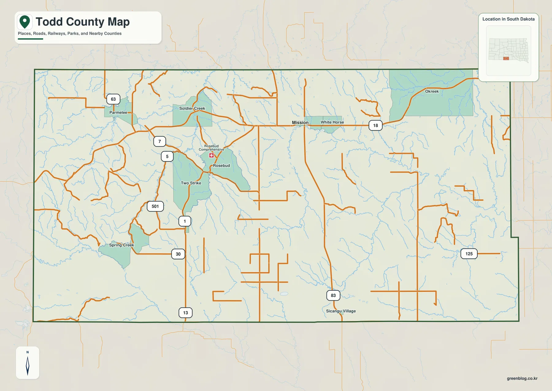
Mission is positioned near the north-central part of the county and gives the road map a useful anchor. US 18 crosses this part of Todd County from west to east, passing Mission and continuing toward White Horse and Okreek. A major north-south route drops from the Mission area toward Sicangu Village, while the western half contains a denser web of numbered local roads around Parmelee, Rosebud, Two Strike, and Spring Creek. This arrangement makes the general map more useful for regional orientation than a simple list of place names.
The settlement pattern is noticeably dispersed. Parmelee and Soldier Creek appear in the northwest, Rosebud and Two Strike occupy the west-central area, and Spring Creek lies farther southwest. Mission and White Horse form a separate northern corridor, Okreek sits toward the northeast, and Sicangu Village is much farther south. None of these places alone represents the entire county. Seeing them inside one boundary is important because the distances and intervening terrain are easy to underestimate when the names are viewed only in a directory or search result.
The county outline is mostly composed of long straight segments, but the eastern boundary steps outward near the southeast rather than continuing as one simple rectangle. Labels outside the boundary place Mellette County to the north, Tripp County to the east, and Bennett and Jackson counties to the west. Todd County also reaches South Dakota’s southern state line. These surrounding references are useful when comparing maps across the region, especially because several local roads continue toward neighboring counties even when the Todd County map stops at the boundary.
Road shape changes from one side of the county to the other. Western routes frequently bend around creek valleys and dissected ground, while longer straight segments are more common in parts of the central and eastern interior. The map labels routes 63, 7, 5, 1, 30, 13, 83, 125 and others, but the purpose here is not turn-by-turn navigation. It is to show how communities sit relative to the larger corridors. Current closures, surface conditions, and travel times should be checked through current transportation sources before making a trip.
The ranked city view isolates Mission and St. Francis from the wider community network
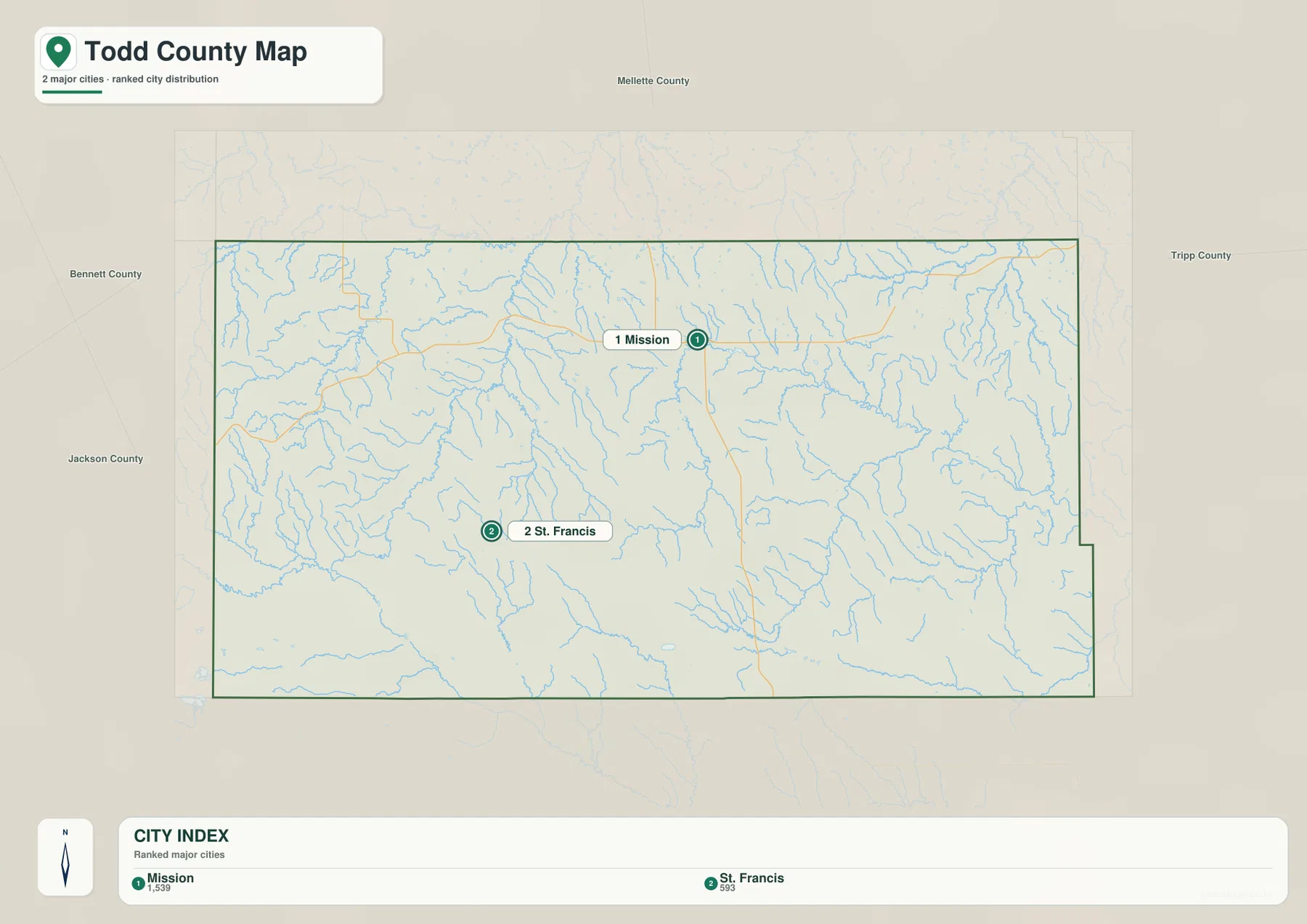
The city map deliberately strips away most settlement labels and highlights only two ranked locations. Mission is marker 1 and St. Francis is marker 2. The printed index shows values of 1,539 for Mission and 593 for St. Francis. Those are the values carried by this specific ranking layer, so they should not automatically be treated as the newest population estimates. Anyone who needs current demographic counts should use current Census tables rather than reading the map index as a live population source.
Mission sits north and east of St. Francis. The difference is large enough to be obvious even on the simplified map: Mission is close to the northern road corridor, while St. Francis occupies the western interior well to the southwest. The background also shows numerous drainage lines between them. No connector distance is printed, and the map is not designed to calculate driving mileage. Its value is visual separation—showing that the two ranked places belong to different parts of a geographically broad county.
It is equally important to notice what the ranked map does not show. Rosebud, Parmelee, Okreek, Soldier Creek, Two Strike, and other communities remain part of the county even though they are not numbered here. For a presentation focused specifically on Mission and St. Francis, the city layer removes distracting labels and works well. For cultural, road, or community context across the Rosebud area, the general county map is the better companion because it preserves the wider set of named places.
Little White River cuts through the west while Keya Paha drainage dominates the east
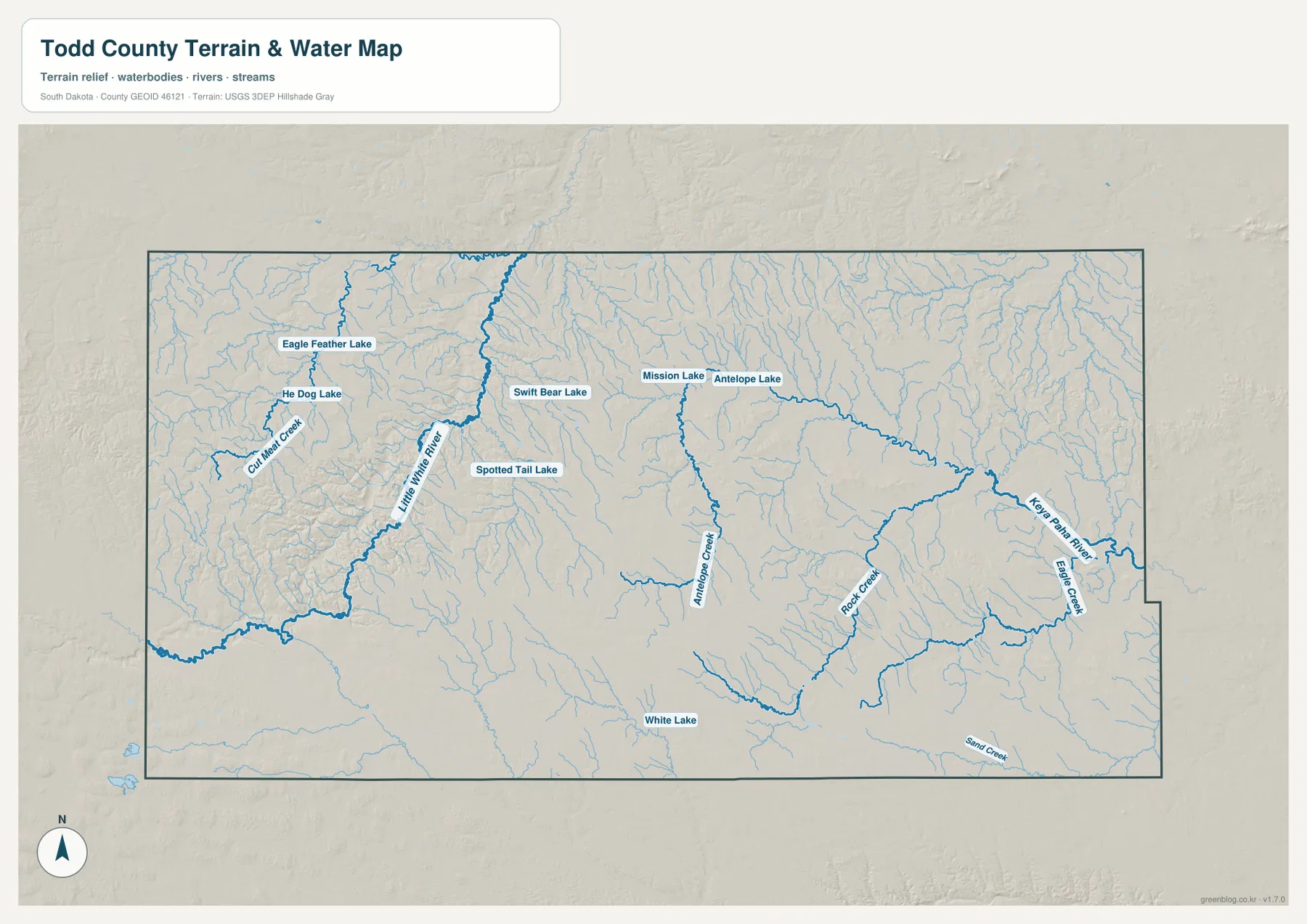
The western half of the terrain-and-water map is organized around the Little White River. Its channel is drawn much more prominently than most smaller streams, and the shaded relief shows a deeply incised corridor around it. Cut Meat Creek enters the drainage from the northwest, while Eagle Feather Lake and He Dog Lake sit nearby. Swift Bear Lake and Spotted Tail Lake lie farther east of the main river. Together these features give the western side a distinctly broken, valley-cut appearance rather than the look of a uniform plain.
Near the north-central part of Todd County, Mission Lake and Antelope Lake form a second cluster of named water features. Antelope Creek extends southward from that general area and remains visible for a long distance across the interior. Farther southeast, Rock Creek becomes one of the stronger mapped channels before the drainage approaches the eastern side of the county. This middle section is useful for seeing how smaller streams connect areas that look relatively open on the road map.
The eastern edge belongs to a different drainage pattern. Keya Paha River is labeled prominently near the county boundary, with Eagle Creek joining the network nearby. White Lake is marked in the south-central area, and Sand Creek appears near the southeastern margin. The large number of fine blue tributaries across the map indicates extensive local drainage even where no large lake or major river name is present. Comparing the west and east makes it clear that Todd County is crossed by multiple drainage systems rather than being organized around one central river.
This layer is intended for geographic reference, not water-safety decisions. It does not show flood probabilities, real-time discharge, water quality, fishing rules, road inundation, parcel ownership, or legal access. Some small channels may also be intermittent. Use current USGS and relevant local or tribal information when conditions on a specific river, creek, lake, or crossing matter. The map is best used to understand relative location and the relationship between waterways and terrain.
Western uplands stand well above the lower green terrain toward the east
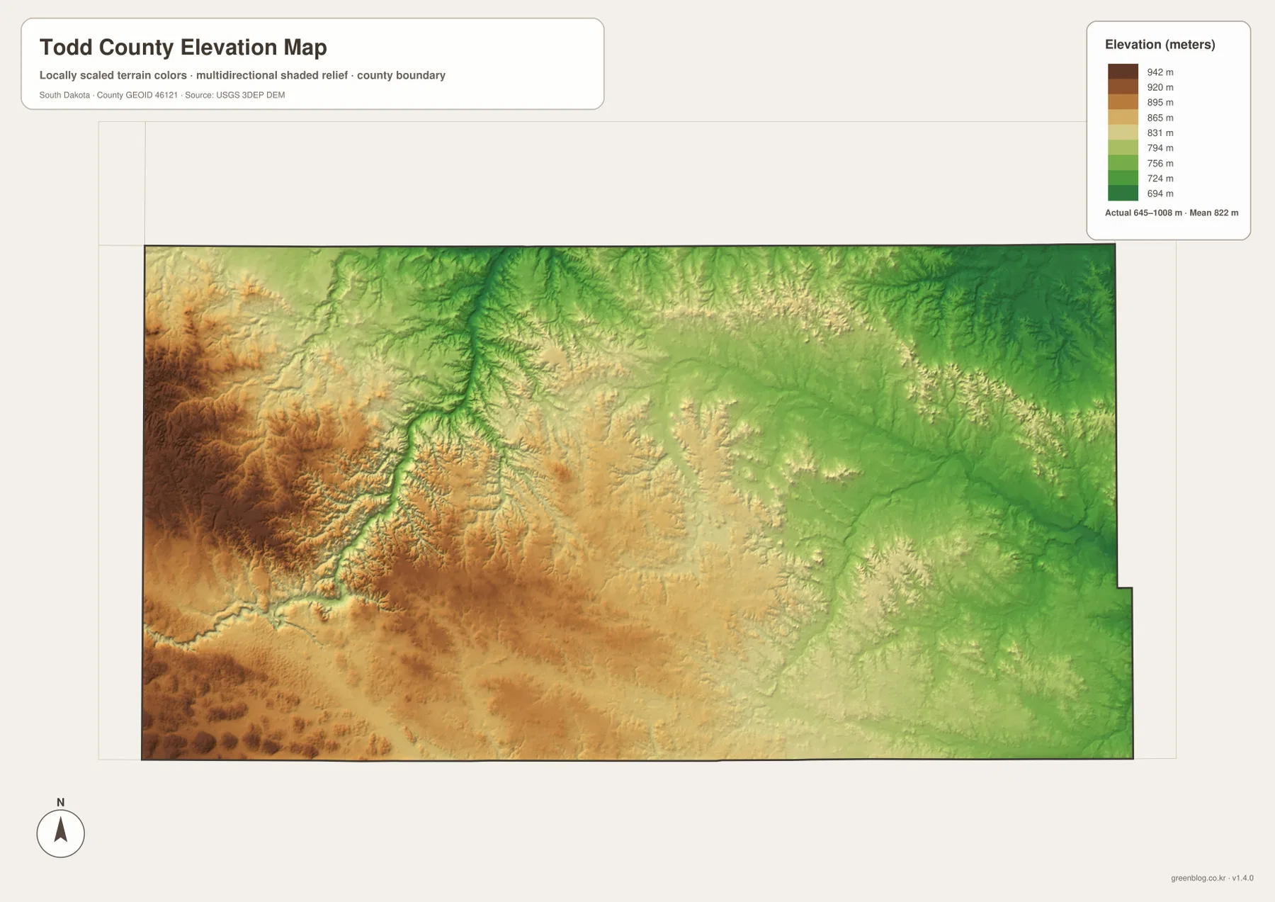
The elevation legend gives an actual mapped range of about 645 to 1,008 meters, with a mean near 822 meters. Brown and orange tones dominate much of the west and southwest, indicating higher ground, while green shades spread across the east and northeast. The center forms a broad transition between these zones. Todd County therefore has a strong regional elevation gradient even though it does not contain the dramatic mountain relief seen in western South Dakota.
The Little White River valley is one of the most informative details on the elevation surface. A lower green corridor cuts through higher western terrain and is fed by many smaller incised valleys. The surrounding ridges and uplands remain yellow, orange, or brown. When the elevation map is placed beside the water map, the relationship is immediate: the bold river line follows the lower land, while tributaries occupy narrow cuts through higher ground. This is a much more useful way to understand the western terrain than simply describing it as “higher.”
Lower elevation does not mean the eastern side is featureless. Shaded relief reveals many shallow valleys and branching drainage lines, and isolated rises appear across the central and southeastern areas. The Keya Paha and Rock Creek drainages occupy some of the lower corridors. These subtle features help explain why the county’s streams form such a dense branching network on the water map even where the elevation colors change gradually.
The surface is a generalized county-scale reference derived from USGS 3DEP elevation data. It works well for comparing broad relief and locating major low corridors, but it is not survey-grade or engineering-grade measurement. Exact site elevations, construction design, drainage calculations, or slope safety work require original elevation data and purpose-specific professional information. The 645–1,008 meter range describes the mapped county as a whole, not the guaranteed elevation of any particular road or property.
Choose the community map for orientation and the physical maps for valleys and relief
For most readers, the general map is the logical first choice because it combines the county boundary, Mission, Rosebud, Parmelee, Okreek, Spring Creek, major road corridors, and neighboring-county context. The ranked city map is much narrower: it is useful when the question is simply where Mission and St. Francis sit relative to one another. Switching between those two prevents a common mistake—assuming that places missing from the ranked layer are absent from Todd County.
Questions about the natural landscape call for a different pair. The terrain-and-water map is the direct source for Little White River, Keya Paha River, Mission Lake, Antelope Lake, and named creeks. The elevation map explains why the western drainage looks more deeply cut and why the eastern side occupies lower terrain. Viewing them together also helps connect road shape with landform: winding western routes cross a more dissected landscape, while some central and eastern road segments traverse broader areas with gentler regional relief.
The WebP images in the article are optimized for on-page viewing. When small labels need to be enlarged or a map needs to be placed in a printed handout, the original JPG files in the download archive are more suitable. Each source JPG is 3638×2572 pixels. They can be useful for education, presentations, personal reference, and county comparison, but legal boundary work, flood assessment, navigation, land ownership, and survey decisions should always rely on current authoritative datasets created for those specific purposes.
Frequently Asked Questions
Why are Mission and St. Francis numbered while Rosebud and Parmelee are not?
The ranked city layer intentionally highlights only Mission and St. Francis. The general county map includes a much broader community set, including Rosebud, Parmelee, Soldier Creek, Two Strike, Spring Creek, and Okreek. A place being absent from the numbered city layer does not mean that it lies outside Todd County or lacks local importance.
Can the Little White River map be used as a flood or access map?
No. It shows the relative positions of rivers, lakes, creeks, and terrain but does not include flood zones, current water levels, road closures, property access, or water-use regulations. Use current USGS and relevant local or tribal sources for safety, access, and real-time conditions.
Does the 645–1,008 meter elevation range provide exact site elevations?
No. The elevation map is designed for countywide comparison. It shows the higher western uplands, lower eastern terrain, and major valley cuts clearly, but exact elevations for a building site, road project, or survey point require the original USGS 3DEP data or professional survey measurements.
Map File Information
The archive contains the Todd County general map, ranked city map, terrain-and-water map, and elevation map as original high-resolution JPG files.
- Included Files: 4 JPG maps
- Printable Size: 3638×2572 pixels each
- Intended Use: Printing, education, presentations, and geographic reference
Related Maps
Sources and References
- U.S. Census Bureau QuickFacts – Todd County, South Dakota: county land area and population-density reference
- Rosebud Sioux Tribe – Tribal Government: official tribal government and community information for the Rosebud area
- South Dakota – Todd County: Native Heritage: state background on Todd County and the Rosebud Indian Reservation
- South Dakota Department of Transportation – CADD Mapping: official state, county, city, and highway map resources
- USGS National Hydrography: official reference for rivers, lakes, streams, and other hydrographic features
- USGS 3D Elevation Program: elevation-data reference for the county elevation map
Green Map creates custom-edited map images using open geographic data sources such as geoBoundaries, Natural Earth, OpenStreetMap, and government open data.
These maps are edited visual materials, not raw data files, and are provided for education, documents, presentations, and graphic reference.