You can download four high-resolution A3 JPG maps of Lavaca County in one ZIP directly from this page. The set includes a general county map, a city-connections map, a terrain-and-water map, and an elevation map. The maps show Yoakum, Hallettsville, Shiner, and Moulton, roads marked 90A, 95, 77A, 77, and 111, the Lavaca and Navidad river systems, and an actual elevation range of about 25 to 171 meters.
Yoakum and Hallettsville are useful reference points because they sit in different parts of the more developed western half of the county. Shiner lies north of Yoakum and west of Hallettsville, while Moulton is farther north. The road map makes those settlement relationships clear; the water map then reveals the dense creek network between them, and the elevation layer shows how the higher western terrain falls toward lower valleys in the east and southeast.
Table of Contents
The busiest road pattern lies between Yoakum, Shiner, and Hallettsville
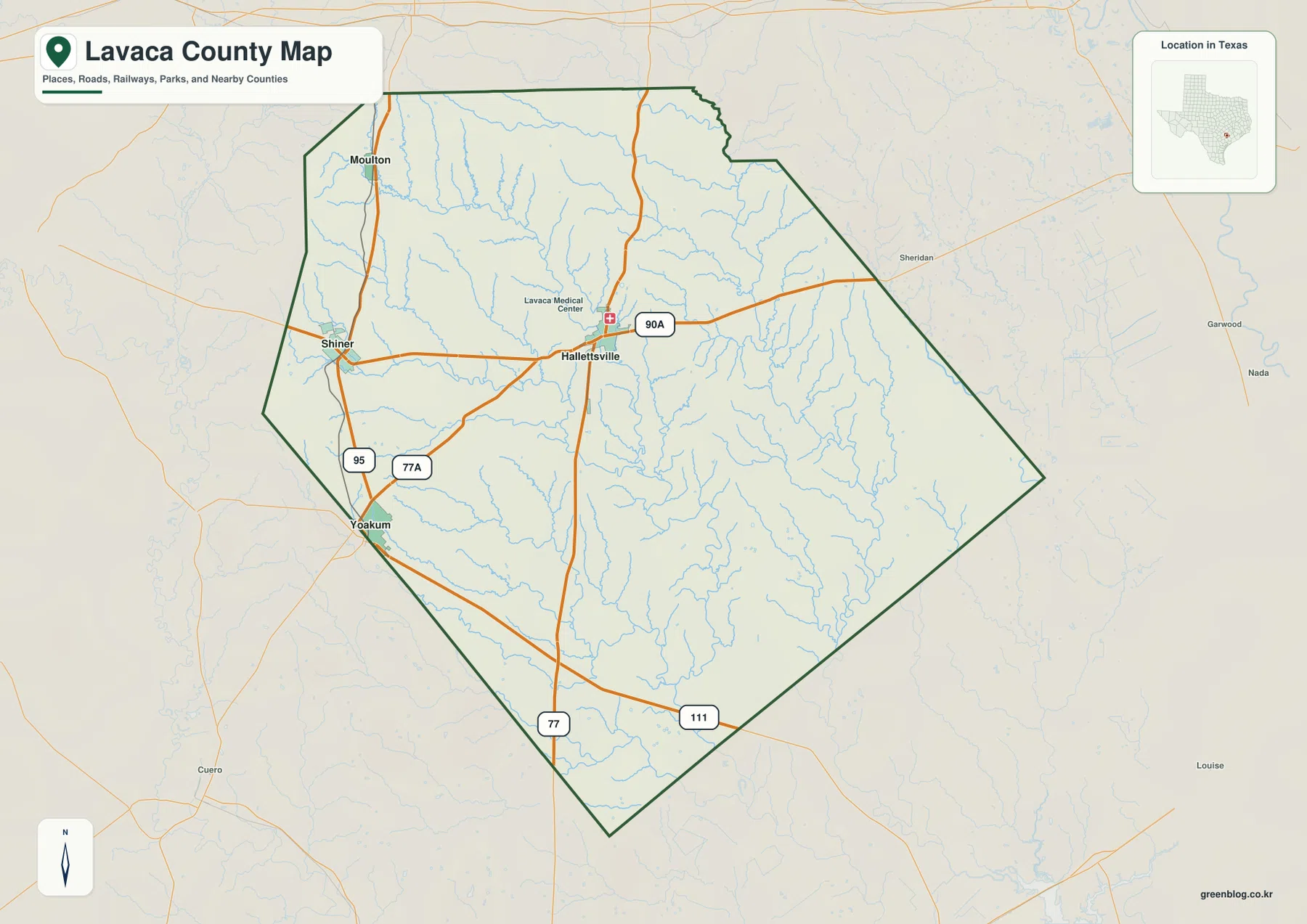
The general county map places Hallettsville near the west-central part of Lavaca County. Route 90A passes through the Hallettsville area from west to east, and the road marked 77 runs north-south through the same general corridor. Yoakum sits near the southwestern boundary, where routes 95 and 77A provide two of the clearest road references. The combination of settlement labels and orange road lines makes the western side visually denser than the eastern half.
Shiner lies between the Yoakum and Hallettsville areas, close to Route 90A and the north-south road marked 95. Moulton is farther north along the western side. Route 77 continues south from the Hallettsville area, while 111 crosses the southern part of the county toward the southeast. These roads do not create a single straight settlement chain; instead, they connect four towns that occupy different positions across the western and central part of the county.
Lavaca Medical Center is also labeled near Hallettsville and can serve as a secondary visual reference for locating the town. The page does not use that facility label to infer services or medical coverage. It is simply one of the clearly visible map labels that helps a reader identify the Hallettsville area before moving on to the county’s water and terrain features.
Yoakum is the hub on the city-connections map
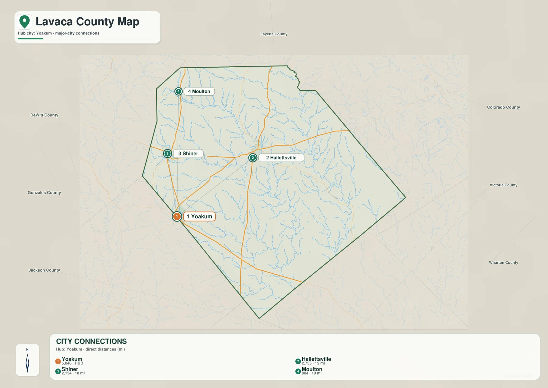
The city-connections map uses Yoakum as the hub and highlights Hallettsville, Shiner, and Moulton as connected major cities. The legend shows about 15 miles from Yoakum to Hallettsville, 10 miles to Shiner, and 19 miles to Moulton. These are direct straight-line distances between mapped points, not driving distances along the highway network.
The directions are as useful as the numbers. Shiner sits north of Yoakum, Moulton is farther north, and Hallettsville is northeast of the hub. Because the simplified city view removes most road labels, the separation between the four places is easier to see than it is on the general map. The general map becomes the better choice when the question shifts from relative position to actual road direction.
County names around the outside provide regional context. DeWitt and Gonzales counties lie to the west, Jackson to the southwest, Fayette to the north, and Colorado, Victoria, and Wharton counties appear around the eastern side. These labels help place Lavaca County among its neighbors without adding place names that are not visible on the supplied maps.
Lavaca River and Navidad River organize the water map
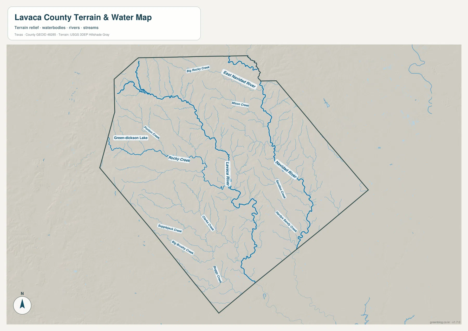
The terrain-and-water map gives the Lavaca River and Navidad River the strongest visual emphasis. The Lavaca River runs through the central part of the county and bends southward, while the Navidad River follows a separate course farther east. Numerous smaller tributaries join both systems, so the county appears much more finely divided by waterways here than it does on the road map.
In the north, East Navidad River and Big Rocky Creek are clearly labeled, with Mixon Creek farther south. Ponton Creek and Rocky Creek appear on the western side, and Green-Dickson Lake provides an easily identifiable standing-water reference near the west. These names are useful because they turn the dense network of blue lines into specific locations that can be compared with the nearby towns and roads.
The southwestern part of the map labels Supplejack Creek and Big Brushy Creek, while Clark Creek and Boggy Creek appear farther toward the center and south. Smaller tributaries also spread across the eastern half toward the Navidad River. This map is intended as a geographic water reference; it should not be treated as a flood-hazard map, parcel boundary map, legal water-boundary product, or navigation chart.
Higher ground in the west descends toward lower eastern valleys
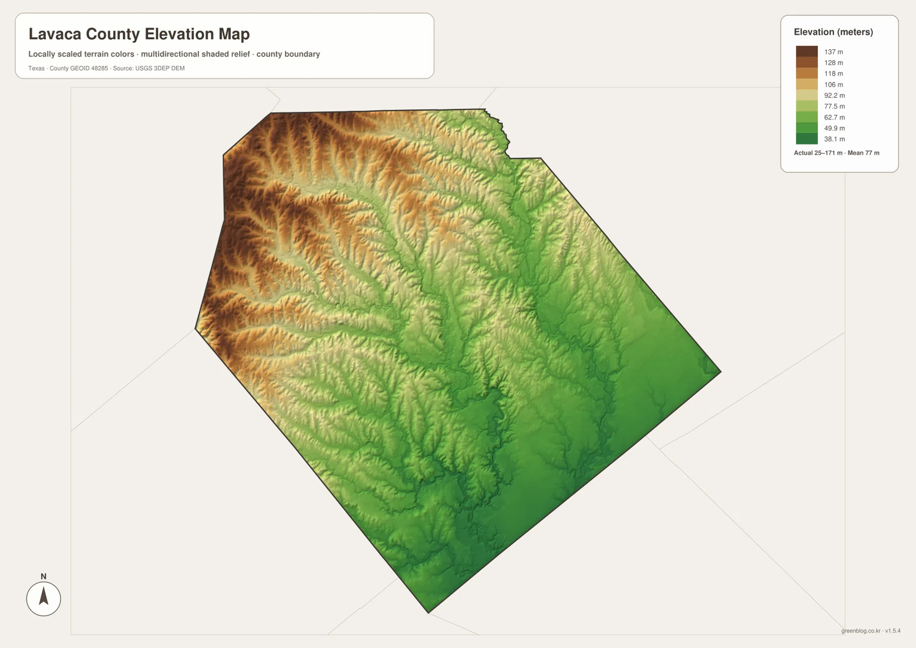
The elevation map reports an actual range of about 25 to 171 meters and a mean elevation of about 77 meters. Brown and tan colors dominate the west and northwest, showing the higher terrain. Greens spread across much of the east and southeast, where the land surface is lower. The color transition is broad enough to make the west-to-east difference visible even before individual creek valleys are examined.
The river network explains much of the detailed relief. Lower corridors follow the Lavaca River and Navidad River, and smaller green branches extend into the surrounding higher ground along tributaries. The western part is not a flat high surface; it contains repeated ridges and narrow creek valleys. The eastern and southeastern sections are generally lower and smoother in the shaded relief.
The displayed difference between the minimum and maximum elevation is about 146 meters. That is enough to create clear county-wide relief, but the map should still be treated as a generalized elevation view rather than survey-grade or engineering-grade measurement. Its best use is comparing which parts of Lavaca County are relatively high or low and seeing how those differences correspond to the river network.
Matching roads, rivers, and elevation across the same county outline
The Yoakum-Shiner area is a useful example of how the maps complement one another. On the general map, routes 95, 90A, and 77A provide the clearest references around the two towns. The water map reveals Rocky Creek and other smaller channels in the same western part of the county, while the elevation view shows that this area is generally higher than the broad green terrain farther east.
Hallettsville provides another comparison. Route 90A crosses the town and continues east on the road map. Looking at the same side of the county on the water map brings the Navidad River and its tributaries into view, and the elevation map shows a larger share of lower green terrain. The result is a clearer understanding of the county than a road-only or river-only view can provide.
Use the city-connections map when relative direction and straight-line distance are the main questions. Use the general map for roads and settlement labels, the terrain-and-water map for named rivers and creeks, and the elevation map for the higher-west/lower-east contrast. Small labels can be easier to inspect in the downloadable high-resolution files than in the web previews.
Frequently Asked Questions
What distances does the city map show from Yoakum?
The city-connections map shows about 10 miles from Yoakum to Shiner, 15 miles to Hallettsville, and 19 miles to Moulton. These are straight-line distances between the mapped city points rather than road-driving distances.
Which rivers and creeks are easiest to identify?
The Lavaca River and Navidad River are the largest labeled references. East Navidad River, Big Rocky Creek, Rocky Creek, Mixon Creek, Ponton Creek, and Green-Dickson Lake are also clearly marked on the supplied water map.
What elevation range is shown for Lavaca County?
The elevation map reports an actual range of about 25 to 171 meters and a mean of about 77 meters. The west and northwest are generally higher, while lower terrain becomes more widespread toward the east, southeast, and major river valleys.
Sources and Reference Data
- U.S. Census Bureau TIGER/Line Shapefiles — official county-boundary and road geometry for geographic reference.
- USGS National Hydrography — official resources for rivers, creeks, lakes, and other water features.
- USGS 3D Elevation Program — official elevation resources used for terrain information.
- USGS The National Map Viewer — an official viewer for comparing multiple geographic layers.
Map File Information
Download four high-resolution A3 JPG maps of Lavaca County in one ZIP file.
- Included Files: county map, city-connections map, terrain and water map, elevation map
- File Type: JPG
Related Maps
- Austin County Texas map
- Wharton County Texas map
- Victoria County Texas map
- Bastrop County Texas map
- Washington County Texas map
Green Map creates custom-edited map images using open geographic data sources such as geoBoundaries, Natural Earth, OpenStreetMap, and government open data.
These maps are edited visual materials, not raw data files, and are provided for education, documents, presentations, and graphic reference.