Falls County sits in Central Texas with Marlin near the middle of a broad rural landscape crossed by the Brazos River and a dense network of smaller streams. This page brings together a county road-and-boundary map, a city-connections map centered on Marlin, a terrain-and-water map, and an elevation map so the county can be viewed from several practical angles without treating it as a simple outline. A downloadable ZIP containing the matching high-resolution A3 JPG files is available in the map file box below for printing, classroom work, and local reference.
The maps show a county whose main places are separated by open land rather than merged into one continuous urban area. Marlin is the clearest center, while Lott and Chilton lie to the west, Golinda to the northwest, and Rosebud farther south. The Brazos River bends through the central part of the county, the Little Brazos River runs along the eastern side, and the elevation map shows noticeably higher ground west and north of the major river lowlands.
Table of Contents
Marlin at the Center of the County Road Network
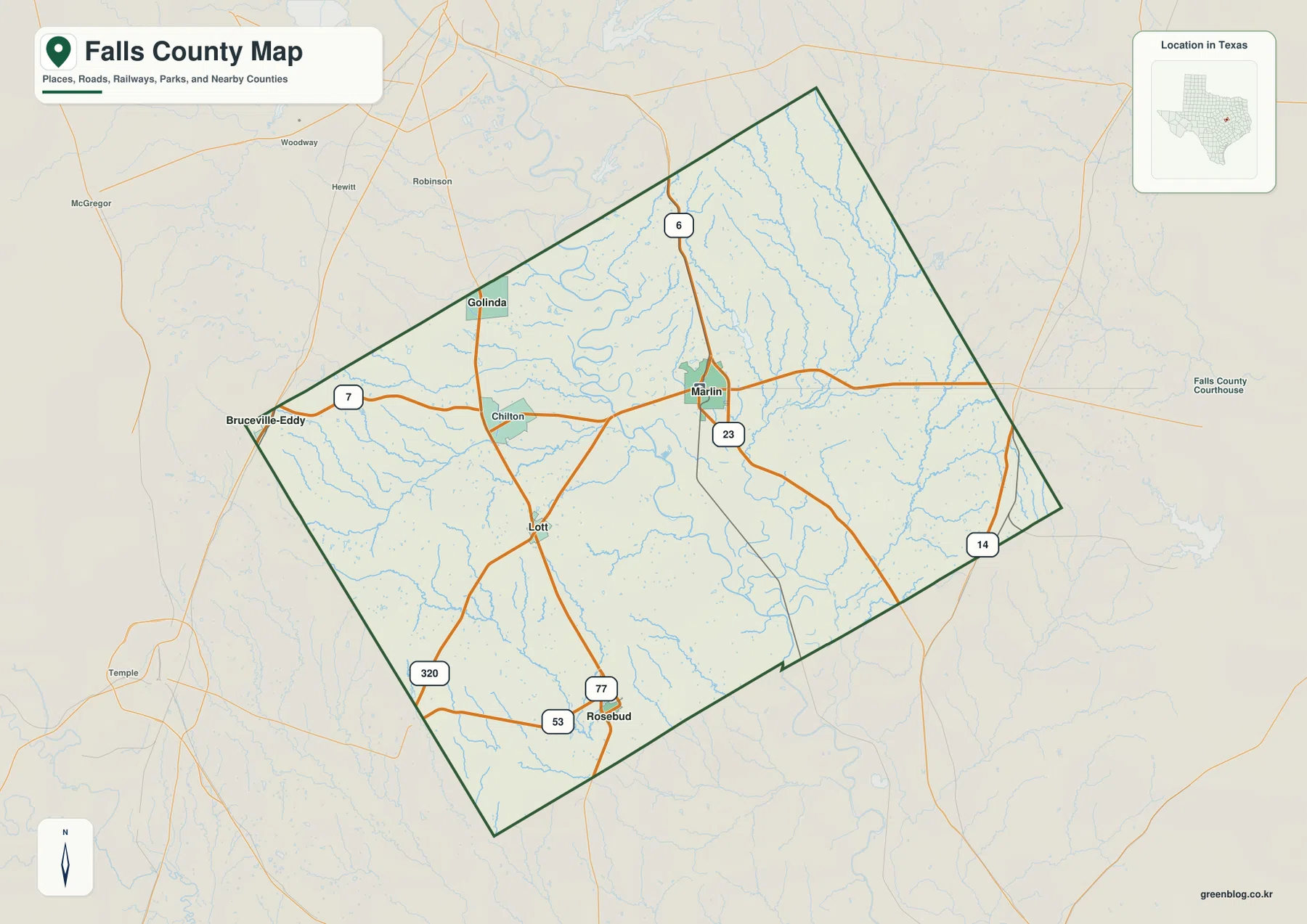
Marlin is the easiest place to use as a starting point on the county map. State Highway 6 enters from the north and passes through Marlin, while State Highway 7 extends west toward Chilton and Bruceville-Eddy. A route marked 23 continues south from Marlin, and Highway 14 appears near the eastern and southeastern edge. On the western side, U.S. 77 runs between the Lott and Rosebud area, with Highways 53 and 320 also visible near the southern part of the county.
The settlement pattern becomes clearer when those roads are followed away from Marlin. Lott is southwest of Marlin, Chilton lies to the west, Golinda is northwest, and Rosebud is farther south near the county boundary. The outline itself is angled rather than rectangular, with a long northern point and diagonal eastern and southern sides. That shape makes roads and towns more reliable orientation markers than assuming the county fits a simple north-south grid.
How Rosebud, Golinda, and Lott Sit Around Marlin
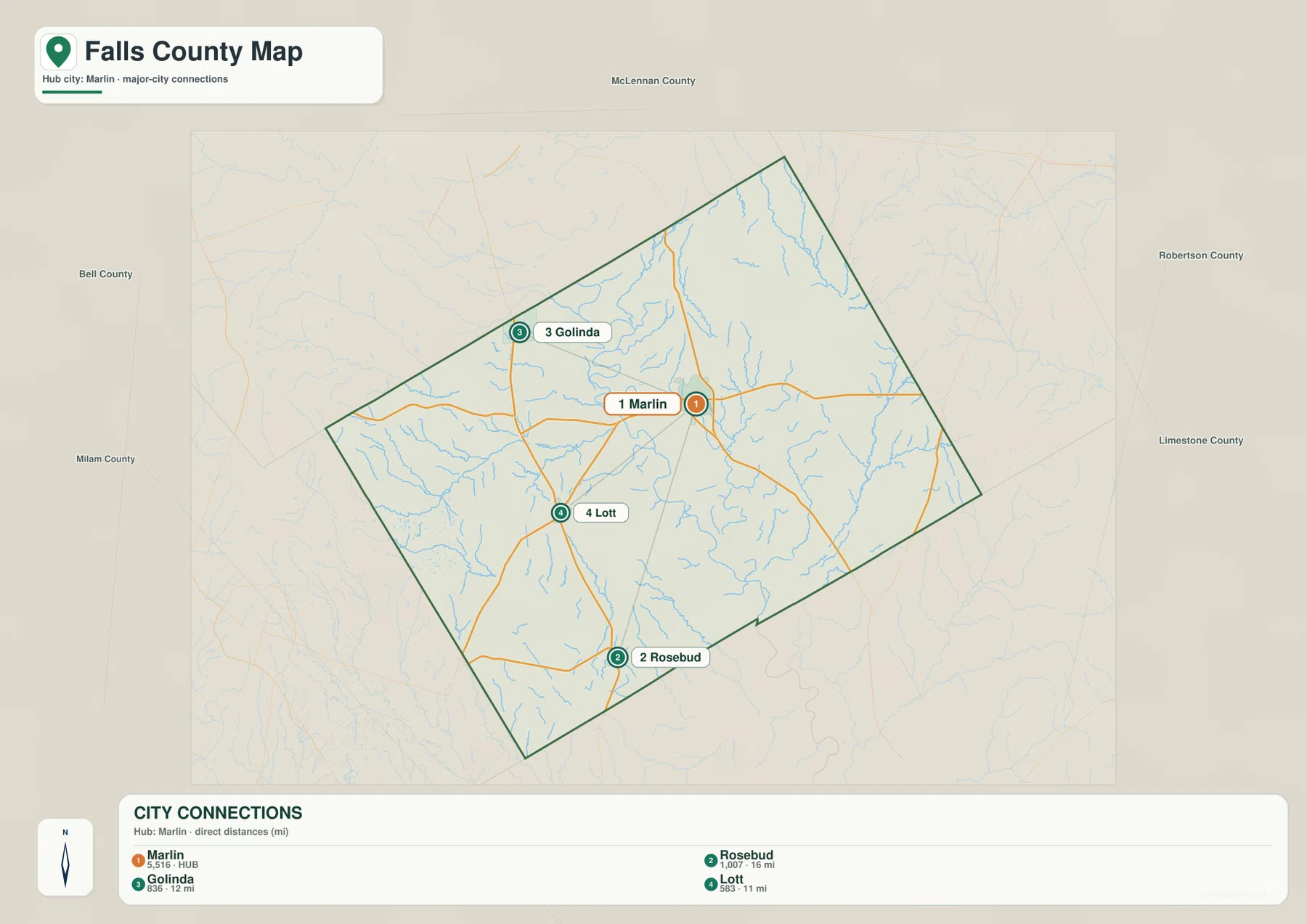
The city-connections map strips away much of the detail and uses Marlin as the hub for three other mapped communities. It lists Marlin at 5,516 residents, Rosebud at 1,007, Golinda at 836, and Lott at 583. More important for map reading, Golinda lies northwest of Marlin, Lott southwest, and Rosebud farther south. The layout makes it clear that the county’s populated places are spread across several directions rather than concentrated along one continuous suburban corridor.
The distance labels are straight-line distances, not driving distances. The map shows roughly 12 miles from Marlin to Golinda, 11 miles to Lott, and 16 miles to Rosebud. Actual road travel can be longer because drivers must follow the available highway network. The city map is therefore useful for comparing spacing and direction, while the county map is better for tracing the route that would actually connect one community to another.
Brazos River Lowlands and the Eastern Stream Network
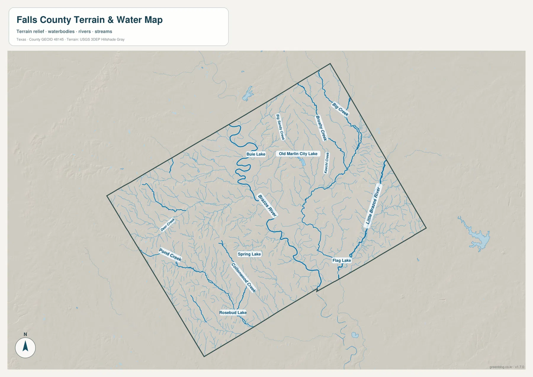
The terrain-and-water map is dominated by the Brazos River, which enters the northern part of Falls County and makes broad bends through the center before continuing south. The Little Brazos River is shown separately along the eastern side. Named tributaries include Big Sandy Creek, Brushy Creek, and Big Creek in the north, with Deer Creek and Pond Creek on the west and Cottonwood Creek farther south. The map makes the county look much more dissected by water than the road map alone suggests.
Several small lakes are also labeled. Buie Lake and Old Marlin City Lake are near the upper central part of the county, Spring Lake appears farther south, Flag Lake lies in the southeast, and Rosebud Lake is near the southwestern side. These features are useful as geographic reference points, but this map is not a flood-hazard map, a legal water-boundary product, or a navigation chart. For location work, it is best used to identify the named water feature before returning to the road map for access and nearby communities.
Elevation Changes Between River Valleys and Uplands
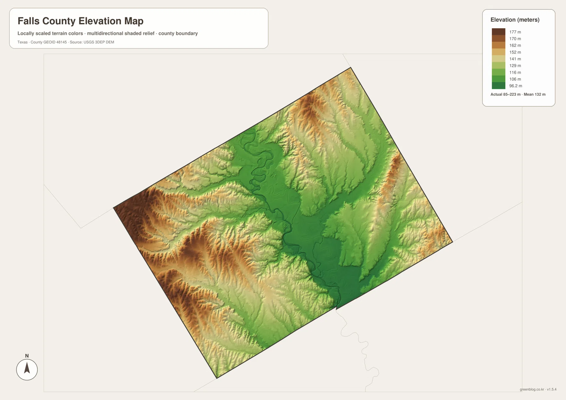
The elevation map shows a substantial difference between the major river valleys and the surrounding uplands. The mapped actual range is about 85 to 223 meters, with a mean near 132 meters. Dark green follows the low central Brazos corridor and other stream valleys, while browns and tans mark higher terrain on the western and southwestern side. Higher ridges and dissected slopes also appear in the north, so the county is not a uniformly flat prairie even though broad lowlands are common.
Comparing this map with the waterways explains much of the color pattern. The lowest ground follows the Brazos River and other drainage corridors, while smaller tributaries cut into higher land around them. Marlin sits east of the main Brazos channel rather than on the lowest part of the river floor, and the Rosebud side includes a mix of ridges and lower drainage lines. The elevation surface is generalized for county-scale viewing and should not be treated as survey-grade or engineering-grade measurement.
What the Maps Show About Falls County’s Landscape
The Handbook of Texas places Falls County in the Blackland Prairie region and describes a landscape of broad flatlands and gently rolling terrain divided by the Brazos River. That description matches the supplied maps well. Large low areas follow the river, but the elevation map also shows higher and more deeply cut terrain west of the river and in parts of the north. The stream map adds another layer by showing how numerous tributaries reach both the Brazos and Little Brazos corridors.
Marlin is both the county seat and the most prominent mapped city. The Handbook of Texas entry for Marlin places the city at the junction of State Highways 6 and 7 and east of the Brazos River, which is consistent with the road map. From that point, Lott, Rosebud, Golinda, and Chilton can be located by following the roads outward. This combination of one central civic reference, scattered smaller communities, a large river, and rolling uplands gives Falls County a map pattern that is distinct from a dense metropolitan county.
Choosing the Best Map for Printing or Reference
Use the county map when roads, community names, and the boundary need to appear together. The city-connections map is better when the question is simply where Rosebud, Golinda, and Lott lie in relation to Marlin. The water map is the clearest choice for the Brazos River, Little Brazos River, named creeks, and lakes, while the elevation map adds the contrast between river bottoms and higher uplands. For a classroom handout, one map may be enough; for field reference, pairing the road map with the water or elevation map usually provides more context.
Frequently Asked Questions
Where should I start when reading a Falls County map?
Start with Marlin near the center of the county, then locate Lott and Chilton to the west, Golinda to the northwest, and Rosebud to the south. From there, follow State Highways 6 and 7 and U.S. 77, then compare those roads with the Brazos River to understand the county’s basic layout.
How can I tell the Brazos River from the Little Brazos River?
The Brazos River is the broad, winding river crossing the central part of the county. The Little Brazos River is a separate north-south waterway closer to the eastern side, so comparing the center and east of the water map makes the two easy to distinguish.
Where is the lowest and highest terrain shown in Falls County?
The lowest mapped ground follows the Brazos River and other stream valleys, while higher terrain is more common on the western, southwestern, and northern sides. The supplied elevation map shows an actual range of roughly 85 to 223 meters, which makes the contrast visible without requiring contour-line interpretation.
Map File Information
Download the Falls County county, city, water, and elevation maps as high-resolution A3 JPG files. The ZIP contains the same map subjects introduced on this page.
- File Type: JPG
Related Maps
- Robertson County Texas map
- Williamson County Texas map
- Washington County Texas map
- Navarro County Texas map
- San Saba County Texas map
Sources and References
- Handbook of Texas – Falls County — Background on county location, the Brazos River, terrain, and settlement.
- Handbook of Texas – Marlin — Reference for the county seat and its highway location.
- USGS National Hydrography — Official reference for rivers, streams, and other mapped hydrographic features.
- USGS 3D Elevation Program — Official U.S. Geological Survey elevation-data program.
- U.S. Census Bureau TIGER/Line Shapefiles — Boundary and transportation reference data.
Green Map creates custom-edited map images using open geographic data sources such as geoBoundaries, Natural Earth, OpenStreetMap, and government open data.
These maps are edited visual materials, not raw data files, and are provided for education, documents, presentations, and graphic reference.