Carroll County is easier to understand when its roads, streams, and terrain are viewed together rather than as separate facts. Carrollton and Vaiden appear as two county seats in different parts of the county, the western side is generally lower than the hillier east and southeast, and a dense network of creeks cuts through the interior. This page uses the supplied maps to explain those relationships in plain terms. You can also download the A3 high-resolution JPG files for the county reference map, city-connections map, terrain-and-water map, and elevation map in one ZIP package.
Table of Contents
A useful starting point for reading Carroll County
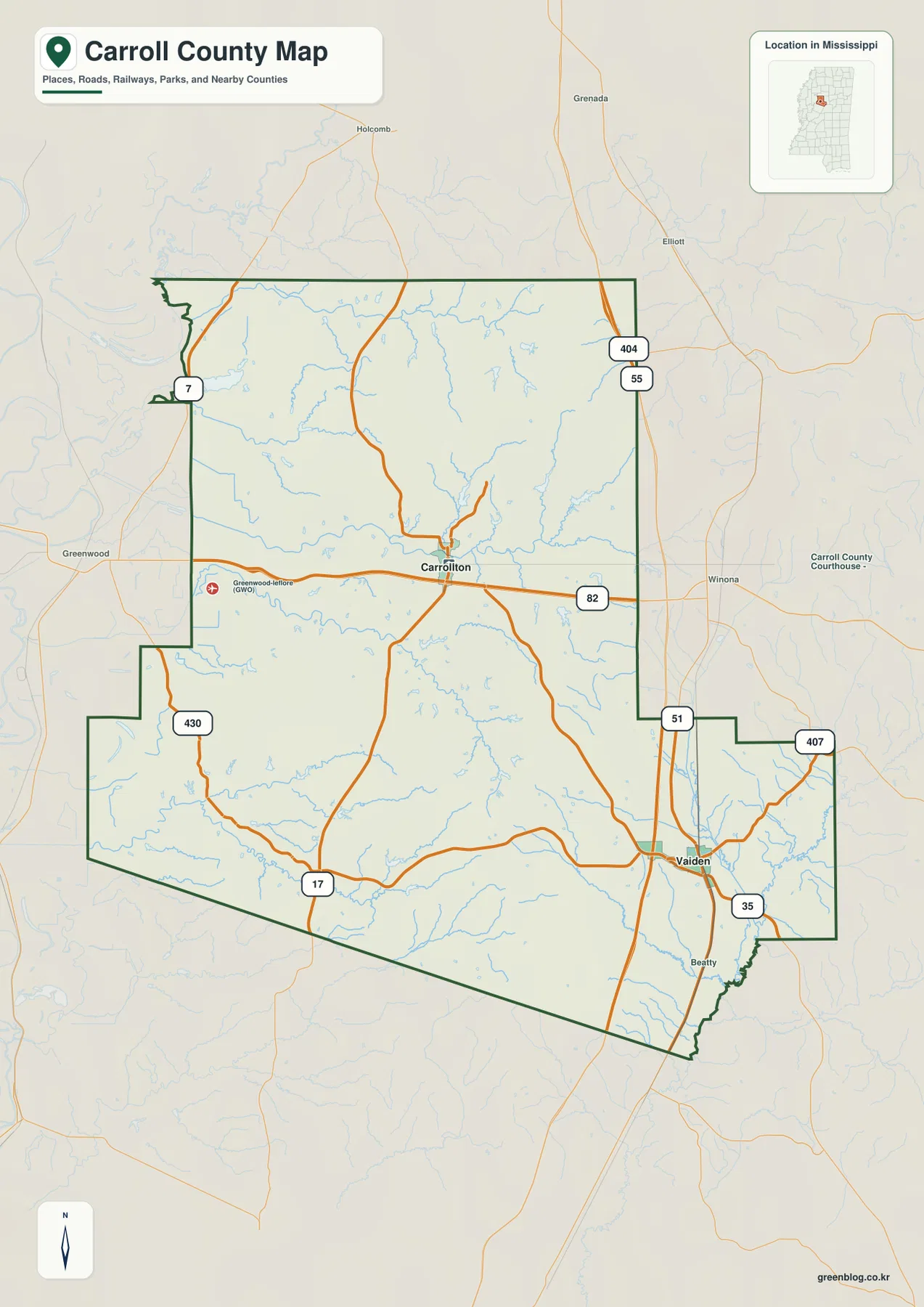
Carroll County lies in north-central Mississippi, and its outline is noticeably irregular along the west and southeast. Carrollton and North Carrollton sit near each other north of the county’s center, while Vaiden is separated to the southeast. The reference map also places Grenada County to the north, Montgomery County to the east, Holmes and Leflore counties to the west, and Attala County along the southwest side. That arrangement matters because Carroll County does not have one compact cluster where all of its major roads and administrative references meet.
| Reference | Value or map label |
|---|---|
| County identifier | Carroll County, Mississippi; FIPS 28015 |
| County seats | Carrollton and Vaiden |
| 2020 census population | 9,998 |
| July 2025 population estimate | 9,226 |
| 2025 Gazetteer area | 628.388 sq mi land; 6.197 sq mi water |
| Elevation shown on the map | About 35–163 m; mean about 95 m |
| Named water features | Big Black River, Big Sand Creek, Pelucia Creek, and several lakes |
The population figures in the table come from different reference dates, so they should not be treated as if they were measured at the same moment. The Gazetteer also separates land from water area. Those statistics are useful for scale, but they do not replace the maps when the question is where a road, town, stream, or ridge actually lies. For that reason, the rest of this guide moves from the general county map to the more specialized city, water, and elevation views.
Two county seats connected by very different road settings
Carrollton is located a little north of the county’s center, with North Carrollton immediately nearby. MS 82 crosses the area east to west, while other state routes approach from the northwest, southwest, and south. Vaiden, by contrast, is positioned in the southeastern section close to the strong north-south corridor formed by US 51 and I-55. The difference is easy to miss if you only compare the two towns by straight-line distance. The road map shows that travelers approach them from different directions and through different route networks.
On the Carrollton side, MS 82 provides the clearest east-west reference and continues toward Winona outside the county. MS 17 and MS 430 help define the more rural western and southwestern portions, while MS 7 reaches the northwest side. Around Vaiden, US 51 and I-55 create a much stronger north-south reference, and routes such as MS 35 and MS 407 connect the southeastern and eastern edges. In practical terms, Vaiden is easier to place from a long-distance north-south route, while Carrollton is the better anchor for understanding movement through the county’s interior and western half.
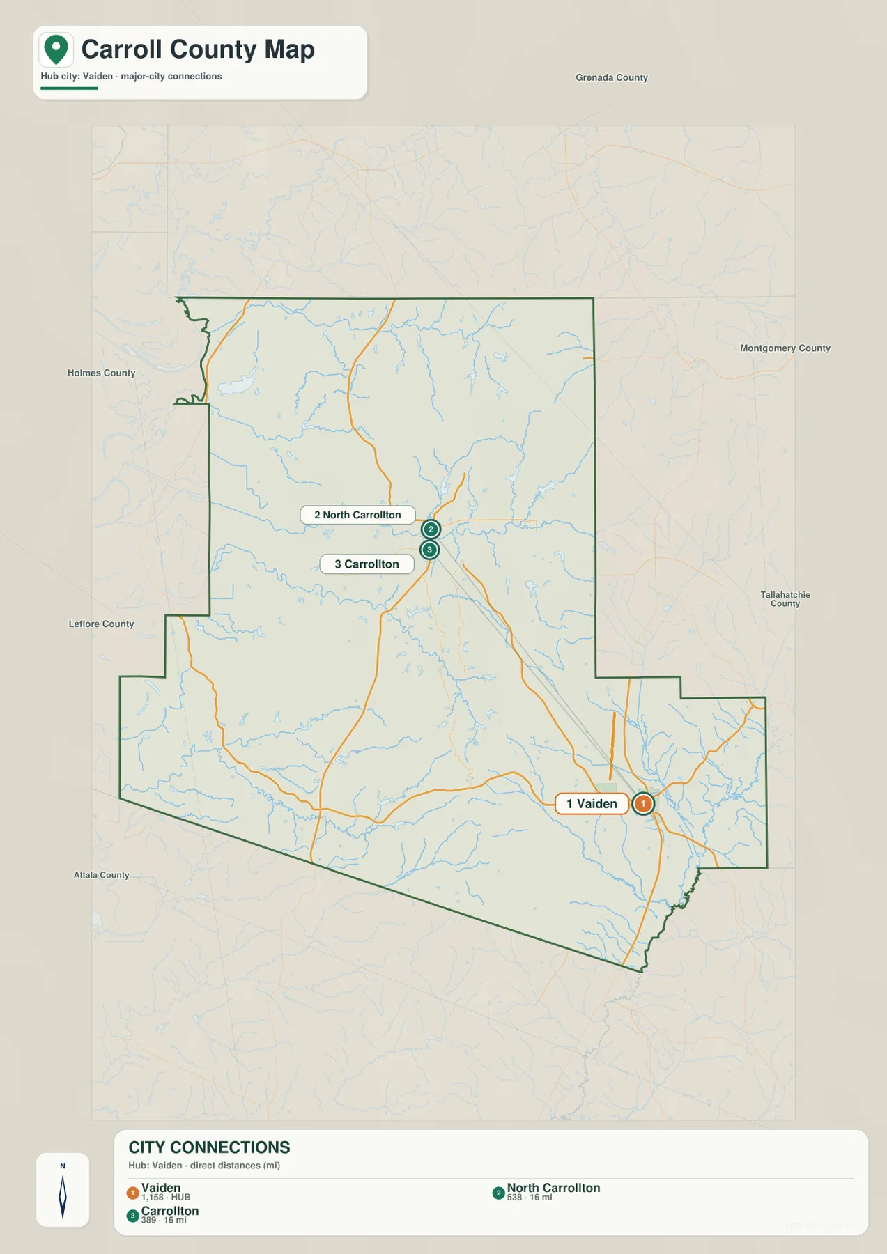
The city-connections map strips away some of the surrounding detail and makes this separation easier to see. Vaiden is marked as the hub, with North Carrollton and Carrollton shown to the northwest as separate labeled points. Because the latter two names appear close together, a reader unfamiliar with the county might assume that one is simply a duplicate label. The map treats them separately, which is useful when a document, address, or local reference depends on the exact place name.
A county shaped by many creeks, not only the Big Black River
The terrain-and-water map makes the county look much more intricate than the road map does. The Big Black River is the most obvious named river, running along the southeastern side, but it is only one part of the drainage picture. Big Sand Creek crosses the central-western portion, Pelucia Creek continues through the interior, and smaller tributaries branch repeatedly across the northern and southern hills. These channels follow low ground between ridges, so they help explain why the county’s interior is divided into many small valleys instead of one broad, flat plain.
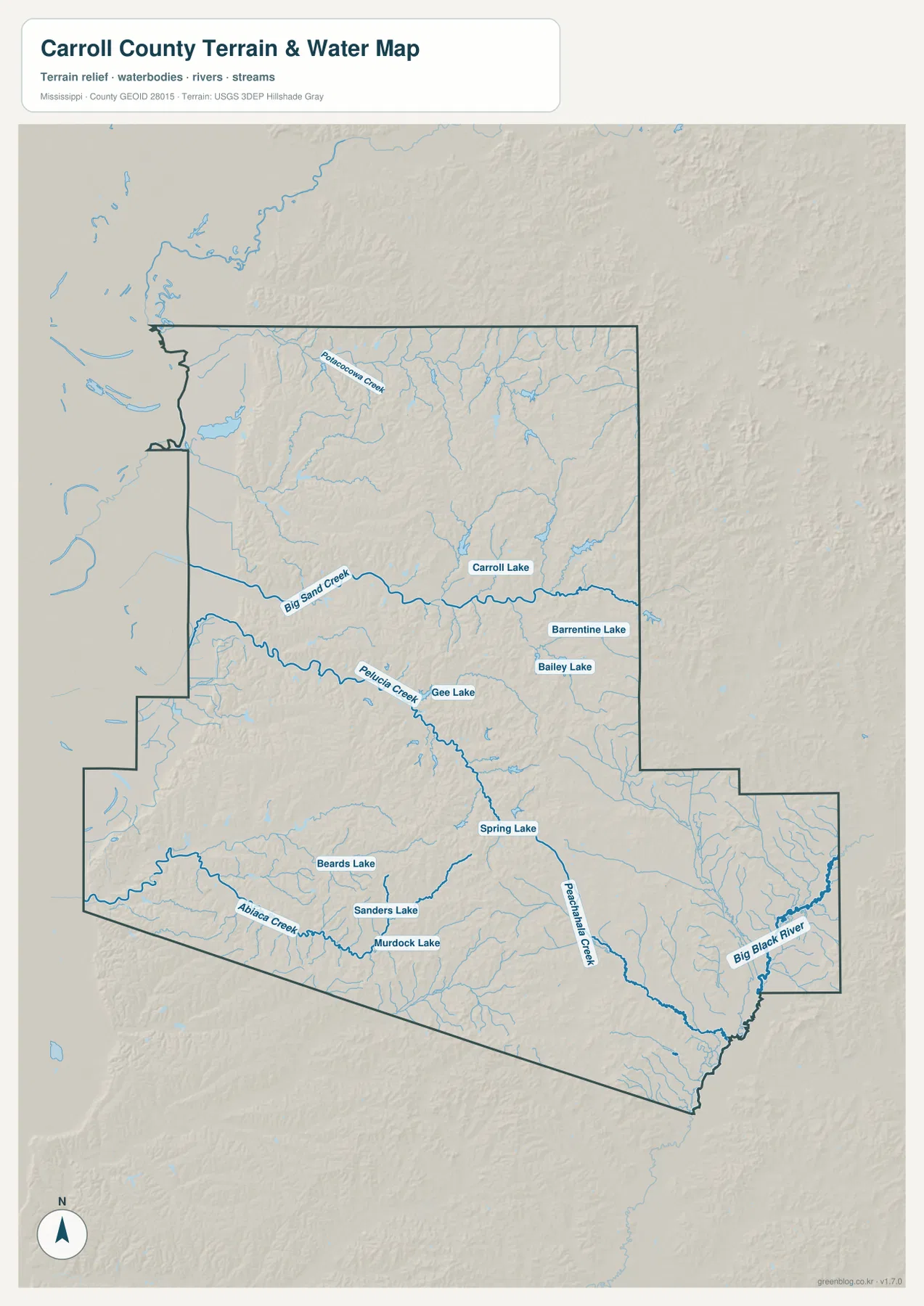
Several lakes are labeled as well. Carroll Lake, Barrentine Lake, Bailey Lake, and Gee Lake appear in the central and eastern part of the county, while Spring Lake is farther south. Beards Lake, Sanders Lake, and Murdock Lake are grouped in the southwestern half. The map does not establish public access, ownership, fishing rules, or exact shoreline conditions, so those questions require a more specific source. What it does show well is that small water bodies are scattered across multiple parts of the county rather than concentrated in a single lake district.
The Big Black River is particularly useful as a southeastern boundary reference near the Vaiden side of the county. Big Sand Creek and Pelucia Creek, on the other hand, run through the interior and are more helpful for understanding the land between Carrollton and the western boundary. Looking at the river and creeks together reveals two scales of water geography: a major river near the edge and a dense system of smaller channels that breaks the interior into ridges and valleys.
From western lowlands to higher eastern ridges
The elevation map shows an actual range of roughly 35 to 163 meters, with a mean near 95 meters. Carroll County is not mountainous, but that range is enough to produce a clear west-to-east contrast. Broad green areas along the western side represent the lower ground. Moving toward the center, narrow valleys begin to cut between more frequent ridges. The eastern and southeastern sections contain more orange and brown terrain, indicating higher and more strongly dissected hills.
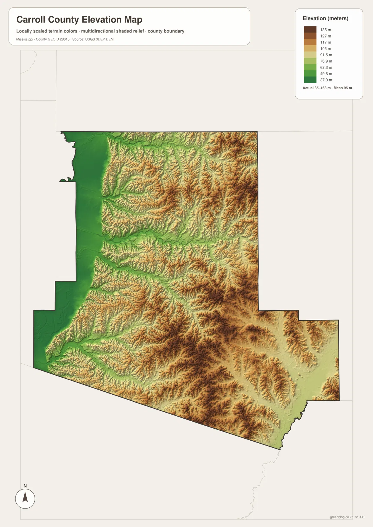
The most useful way to read this image is not to hunt for a single highest point. Instead, follow the contrast between ridges and stream valleys. The western side contains larger areas of relatively low relief, while the center and east show thin low corridors winding between higher ground. Near the Big Black River, lower terrain appears again along the drainage. When the water and elevation maps are viewed side by side, many of the named creeks line up naturally with these lower corridors.
This terrain also adds context to the road map. A road that looks indirect on the reference map may be following a valley, avoiding steeper ridges, or connecting communities through the easier parts of the landscape. The supplied maps are not engineering or route-planning products, but they are detailed enough to show why Carroll County’s internal geography is more complex than a simple east-west distance between two towns.
Which map is best for the task?
Start with the county reference map when you need boundary context, town locations, or major road names. Use the city-connections view when the relationship among Vaiden, Carrollton, and North Carrollton is the main question. The terrain-and-water map is better for named creeks, lakes, and the Big Black River, while the elevation map is the clearest option for explaining the shift from lower western ground to hillier eastern terrain. Keeping those purposes separate makes each image easier to read than a single crowded map that tries to display every layer at once.
- County reference map: boundaries, Carrollton and Vaiden, principal roads, and nearby places
- City-connections map: the separation of Vaiden from Carrollton and North Carrollton
- Terrain-and-water map: Big Black River, Big Sand Creek, Pelucia Creek, lakes, and smaller streams
- Elevation map: the 35–163 m terrain range, western lowlands, and eastern ridges
The WebP images on the page are intended for quick viewing. For printing, presentation slides, document layouts, or image editing, the downloadable package is the better choice because it contains the four maps as high-resolution A3 JPG files. Keeping the originals at full size before reducing them for a document usually produces cleaner labels and linework than enlarging a small screenshot later.
What these maps can and cannot tell you
These images are county-scale reference maps, not substitutes for parcel surveys, legal boundary records, flood determinations, or current road-closure information. A creek line shows where a water feature is represented on the supplied map; it does not show today’s water level or whether the banks are publicly accessible. Likewise, the elevation colors are scaled to make differences within Carroll County visible. The same color on another county map should not automatically be interpreted as the same elevation unless its legend is checked separately.
The road layer should be treated in the same practical way. I-55, US 51, MS 82, MS 17, and MS 35 are excellent orientation references, but the map is not a live navigation service. For a first look at the county, identify the two seats and neighboring counties on the reference map, then compare the water and elevation views. That sequence gives a much clearer sense of the county than reading a list of place names without their terrain and route context.
Frequently Asked Questions
Does Carroll County have two county seats?
The supplied county information lists Carrollton and Vaiden as the county seats, and the maps place them in different parts of the county. Carrollton is in the north-central interior, while Vaiden is farther southeast near the US 51 and I-55 corridor.
Are Carrollton and North Carrollton the same map label?
No. The city-connections map marks North Carrollton and Carrollton as separate places even though their labels are close together. Keeping both names is important when an address, local reference, or administrative description depends on the exact municipality.
What stands out on the Carroll County elevation map?
The map shows a range of about 35 to 163 meters. Lower terrain is broadest along the western side, while the eastern and southeastern sections contain more elevated ridges. Narrow stream valleys cut through the middle, making the water map a useful companion to the elevation view.
Map File Information
The ZIP contains high-resolution A3 JPG originals for the Carroll County reference, city-connections, terrain-and-water, and elevation maps.
- Included Files: county map, city-connections map, water map, elevation map
- File Type: ZIP containing four JPG files
Related Maps
Sources
Population, area, and county background references follow the official links preserved in the supplied package. Water and elevation descriptions are limited to features visible in the provided Carroll County map images.
- U.S. Census Bureau QuickFacts
- U.S. Census Bureau Gazetteer Files
- Mississippi Encyclopedia: Carroll County
- Mississippi Department of Transportation official highway map
- USGS National Hydrography
- USGS 3D Elevation Program
Green Map creates custom-edited map images using open geographic data sources such as geoBoundaries, Natural Earth, OpenStreetMap, and government open data. These maps are edited visual materials, not raw data files, and are provided for education, documents, presentations, and graphic reference.