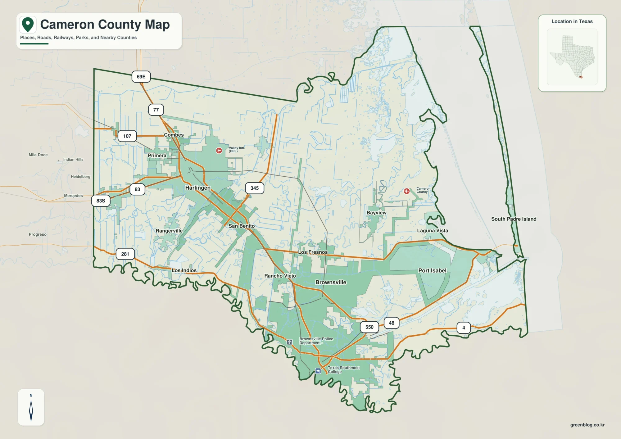
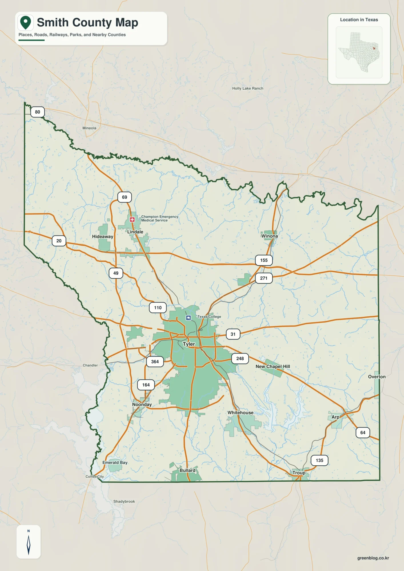
Worth County sits along Iowa’s northern edge, directly below the Minnesota line, and its road pattern makes the county easy to orient once Northwood is located. U.S. 65 runs south from Northwood through Kensett toward Manly, while I-35 and Iowa 27 form a separate north–south corridor farther west. Iowa 9 crosses the southern part of the county near Fertile and Hanlontown before reaching the Manly area. The maps on this page are also available as high-resolution JPG originals in a ZIP file, so labels, streams, and terrain can be enlarged or printed when more detail is needed. High-resolution map files are available for download in the section below.
The strongest natural feature is the Shell Rock River valley near the middle of the county. A long low corridor follows the river southward, separating noticeably higher terrain in the west from generally lower ground toward the east. Smaller streams such as Goose Creek, Deer Creek, and Beaver Creek cut additional valleys through the landscape. Comparing the road map with the water and elevation views reveals a county that looks simple in outline but has a clear west-to-east terrain change.
Worth County’s official website describes the county as part of the northern tier of north-central Iowa and notes that it extends roughly 24 miles from east to west but only about 17 miles from north to south. Northwood is the county seat, and the county government lists seven communities. That broad, relatively shallow shape helps explain why the main north–south highways provide strong reference lines while smaller east–west roads connect communities spread across a longer horizontal distance.
Table of Contents
Northwood, U.S. 65, and the Separate I-35 Corridor
Northwood is the most useful starting point for reading the county map. It is shown in the north-central part of Worth County, with U.S. 65 continuing almost straight south through Kensett and toward Manly. The Worth County Courthouse is in Northwood, so the county’s administrative center and one of its main transportation lines occupy the same general part of the map. Following this route provides a simple way to compare the northern, central, and southern communities without losing orientation.
West of Northwood, I-35 and Iowa 27 run north–south through a different part of the county. They do not pass through the Northwood–Kensett–Manly chain, but they create an important western reference line for regional travel. Iowa 9 crosses the southern portion near Fertile and Hanlontown before meeting the U.S. 65 corridor near Manly. Joice lies farther west, while Grafton is separated from the central highway line on the eastern side.
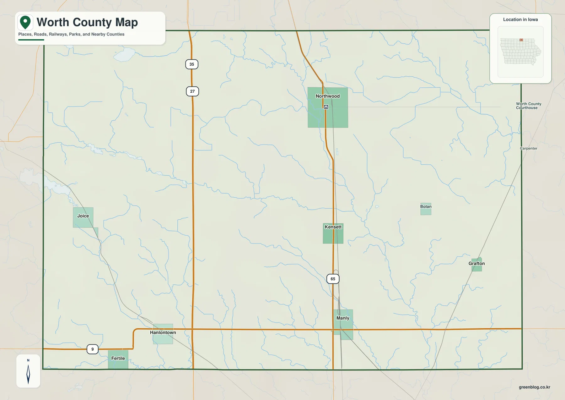
The boundary context is useful as well. Winnebago County is to the west, Mitchell County is to the east, and Cerro Gordo and Hancock counties lie to the south, while Minnesota forms the northern edge. The official county history explains that the northern townships are fractional because of the state boundary. On the map, that gives Worth County a compact north–south dimension compared with its wider east–west span.
This base map is best treated as an orientation map rather than a turn-by-turn navigation product. It clearly shows that U.S. 65 is the direct reference between Northwood, Kensett, and Manly, while western places such as Joice and Fertile require a different combination of highways and local roads. Construction, closures, and travel times can change, so current road information should be checked separately for an actual trip.
Six Ranked Places, Seven County Communities
The settlement view simplifies the county to six ranked places: Northwood, Manly, Grafton, Kensett, Fertile, and Hanlontown. Northwood is shown as the largest of the six, with Manly second, followed by the smaller communities. The purpose of the ranking is to make relative settlement size and spacing easier to compare on the map. It should not be treated as a substitute for a current population table, because official census figures and municipal estimates may be updated independently of the map.
There is a useful difference between this ranked city map and the county government’s community list. Worth County’s official website identifies seven communities, adding Joice to the six places highlighted in the ranked view. Joice is visible on the general county map in the west but is not included among the six ranked places. Comparing the two maps therefore prevents a common misunderstanding: the simplified settlement map is selective, not a complete list of every incorporated community shown elsewhere in the package.
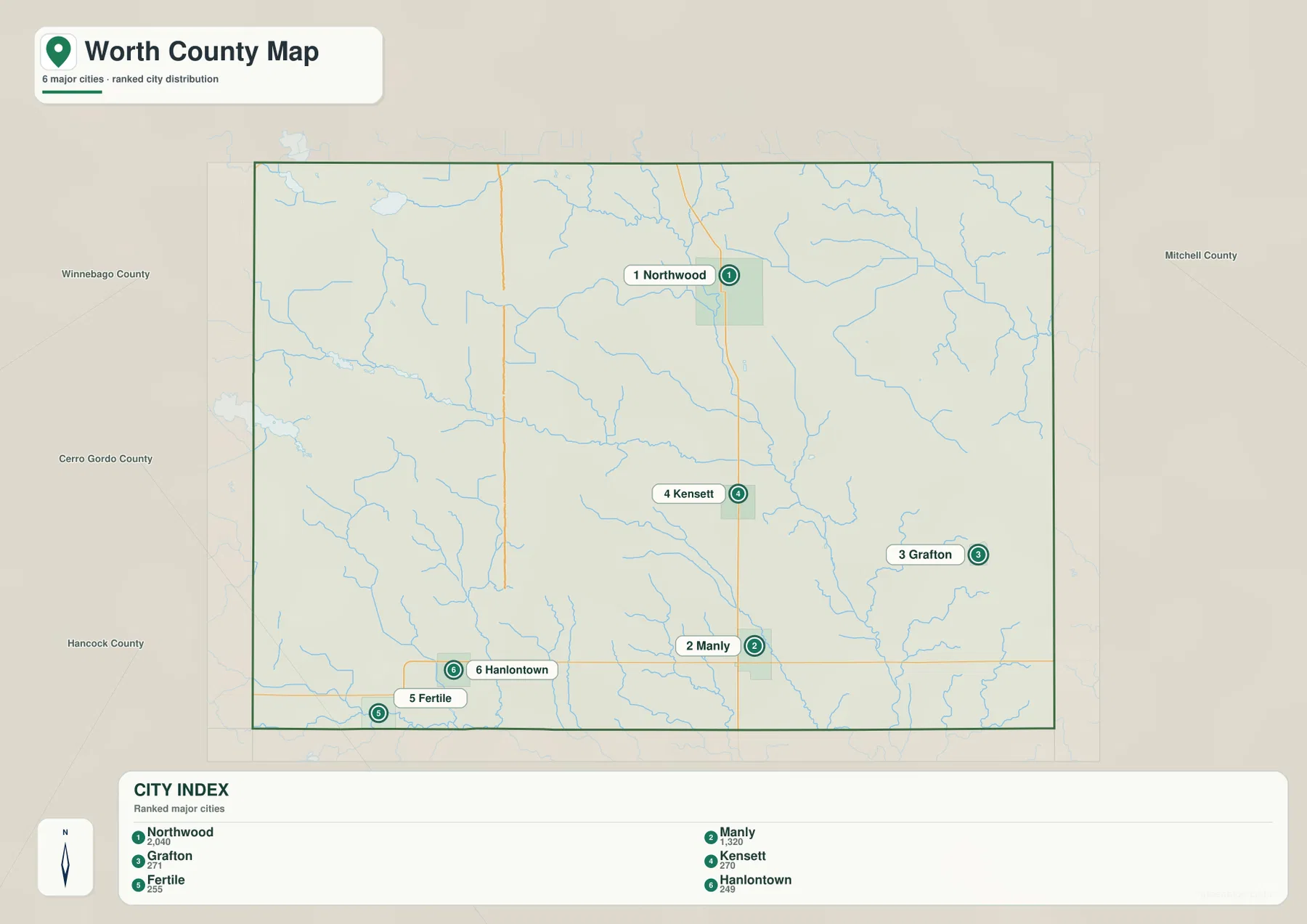
The distribution is not centered on one compact urban cluster. Northwood, Kensett, and Manly form a north–south sequence near U.S. 65, while Grafton sits well to the east. Fertile and Hanlontown occupy the southwestern portion close to Iowa 9, and Joice is farther northwest on the general map. The result is a county where several small communities are separated by agricultural land, streams, and local roads rather than merged into one continuous built-up area.
The ranked city view is especially useful when the question is simply “which direction is one town from another?” or “which places are the main population centers?” It intentionally omits much of the road and stream detail that can distract from settlement spacing. If connector lines or distances are used with this type of map, they should be read as straight-line relationships between locations rather than driving mileage; actual road distance depends on the route taken.
Shell Rock River as the County’s Central Low Corridor
The terrain-and-water map is dominated by Shell Rock River. It enters from the north and winds south through the central part of Worth County, creating a continuous valley that becomes even clearer on the elevation map. The river is not merely another blue line among many smaller streams. Its position provides a natural dividing reference between the higher western terrain and the lower central and eastern portions of the county.
Several lakes and tributaries add detail to that larger pattern. Brights Lake and Silver Lake appear in the northwest, while Rice Lake lies near the western side farther south. Goose Creek approaches the Shell Rock system from the northwest-central area. Deer Creek occupies the northeast, and Beaver Creek forms a long channel in the southeast. Smaller streams, including Willow Creek, Spring Creek, and Blair Creek, show how the broader valley network extends into the southern part of the county.
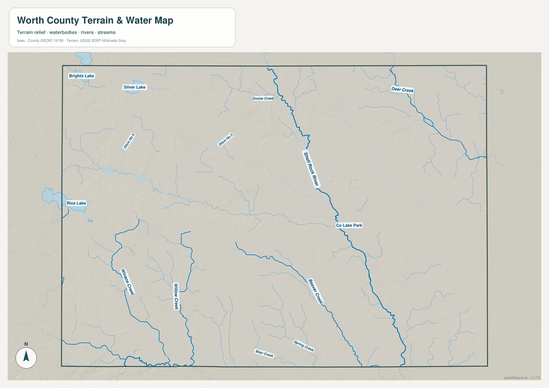
The value of this map becomes greater when it is paired with elevation. The broad green low area on the elevation surface follows the Shell Rock River through the center, while higher western ridges rise quickly away from the valley. Smaller eastern streams also follow low ground, but their relief is less dramatic than the main western-to-central drop. Water and terrain therefore explain one another instead of functioning as two unrelated map themes.
This is a general geographic water-reference map, not a live flood product, parcel map, legal drainage map, or navigation chart. River levels, flood alerts, bridge access, drainage rights, and boating conditions can change and require current official information. The map is best used to locate named rivers, creeks, and lakes and to understand how those waterways fit into the county’s broader landform.
332–414 Meters: High Western Hills and a Lower Central Valley
The supplied elevation map reports an actual range of about 332 to 414 meters, with a mean near 373 meters. The western half contains the most extensive higher ground. Brown and tan ridges dominate the northwest and west-central areas, and narrow green drainage lines cut into those uplands. Moving toward Shell Rock River, the colors shift rapidly into deeper greens, marking a pronounced drop into the central valley.
East of the river, lower green and yellow-green colors are more common. That does not mean the eastern half is completely flat. Deer Creek and other tributaries create shallow valleys, with gentle ridges between them. The relief simply becomes less dramatic than the strongly dissected western uplands. This contrast is one reason the county looks very different on the elevation map than on the more orderly highway-and-town view.
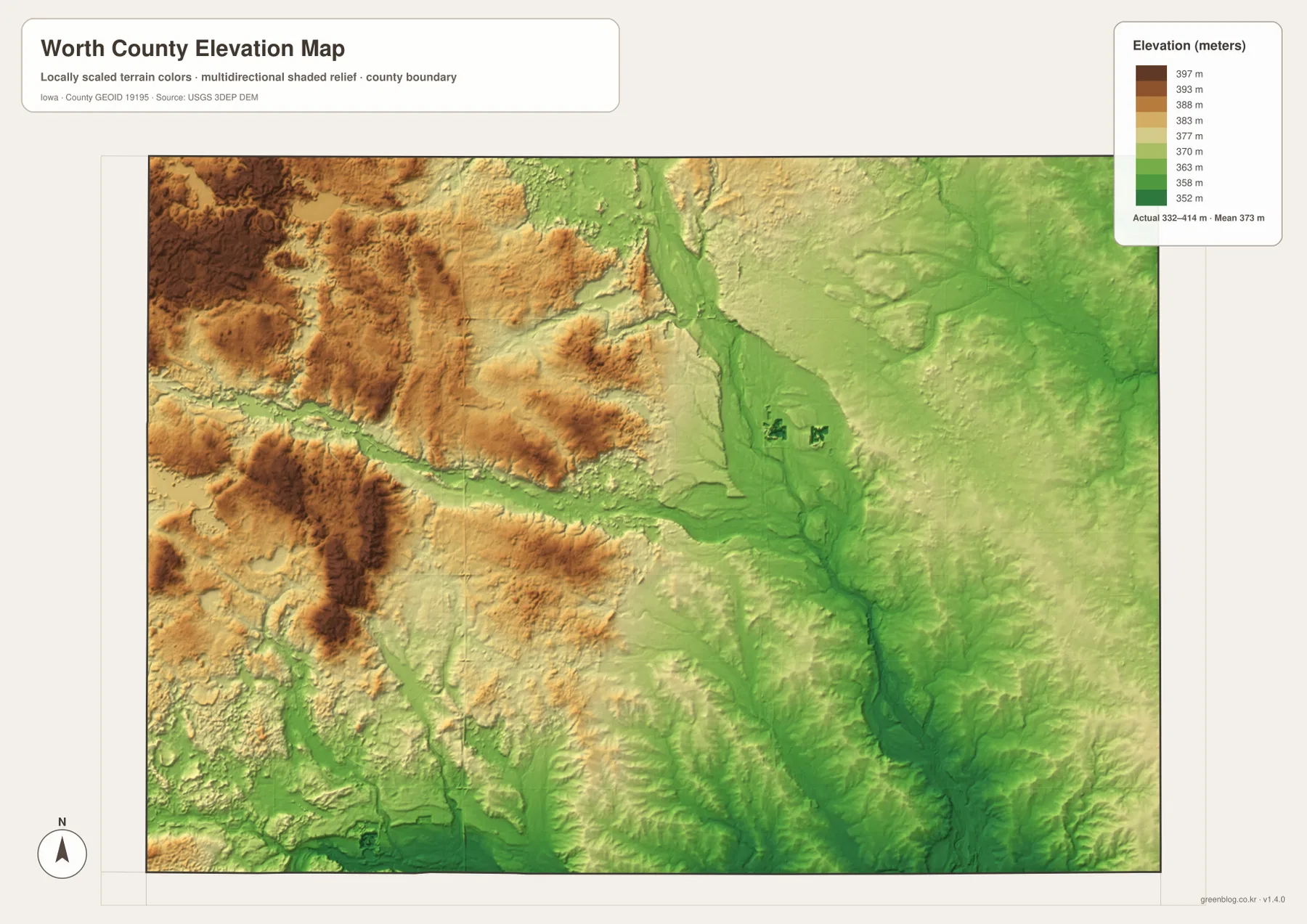
The northern part of the map makes the change especially easy to see. The northwest around Brights Lake and Silver Lake is relatively high, while the terrain lowers quickly toward the Shell Rock corridor. A similar pattern continues southward, although the southern edge is cut by more small streams and low channels. It is more accurate to think of the county as a sequence of uplands and valleys than as a simple slope from west to east.
The elevation surface is intended for regional comparison rather than engineering or surveying. It can show where broad lowlands, stream valleys, and higher ridges occur, but it should not be used to establish the precise elevation of a building, road grade, property corner, or drainage structure. For those purposes, survey-grade measurements and current local records are necessary.
Why the Road Grid and the Terrain Tell Different Stories
Worth County’s roads can make the landscape appear simpler than it really is. U.S. 65 runs in a nearly straight line through the Northwood–Kensett–Manly corridor, I-35 forms another strong north–south line in the west, and Iowa 9 creates a clear east–west reference across the south. Shell Rock River, however, winds through the center, and its tributaries branch in multiple directions. Once the elevation view is added, the straight road grid sits on top of a much more varied pattern of hills and valleys.
The county’s proportions reinforce that difference. Its official history describes a long east–west span and a comparatively short north–south dimension. That shape makes the two major north–south highway corridors efficient reference points, but communities on opposite sides of the county can still be separated by a substantial horizontal distance. Joice and Fertile belong to the western side of the settlement pattern, while Grafton occupies a distinct eastern position across the Shell Rock River system.
Northwood provides a useful way to connect all of these layers. Locate Northwood and U.S. 65 on the base map, then follow the same area on the water map to see Shell Rock River nearby. Finally, compare the elevation surface, where the river’s low corridor is shown in green against higher land to the west. The same part of the county therefore serves as an administrative center, transportation corridor, river valley, and terrain transition depending on which question the reader is asking.
Choosing a Map for Northwood, Manly, or Shell Rock River
For basic location questions, begin with the county map because it keeps Northwood, Manly, Kensett, Joice, Grafton, Fertile, Hanlontown, major highways, railways, and the county boundary in one view. It is the most useful choice for understanding how a town relates to I-35, U.S. 65, or Iowa 9. If the goal is to compare the main settlements without the extra road detail, the ranked city map provides a cleaner picture of spacing and relative size.
For natural features, the best sequence is often the water map followed by elevation. Shell Rock River is easiest to trace on the terrain-and-water view, while the elevation map explains why the river occupies such a distinct low corridor. The same method works for Deer Creek and Beaver Creek, where smaller green valleys can be matched with named streams. Looking at both maps reduces the chance of confusing a low valley with a municipal or road boundary.
When several maps are used for a school assignment, local history note, or personal trip plan, choosing one fixed place as a reference keeps the information organized. Northwood works well because it appears near U.S. 65 and close to the Shell Rock system. Manly is another useful reference because Iowa 9 and U.S. 65 meet in the southern part of the county. The web images are convenient for quick reading, while the downloadable JPG originals are better when small labels need to be enlarged or printed.
Printing each map for a separate purpose can also make the package easier to use. The general county map works for roads and community locations, the ranked settlement map for town comparison, the terrain-and-water map for rivers and creeks, and the elevation map for hills and valleys. Keeping those subjects on separate pages avoids clutter and makes it easier to compare the same location across multiple types of information.
Frequently Asked Questions
Which map is best for following Northwood to Manly?
Start with the general county map. It shows U.S. 65 running south from Northwood through Kensett toward Manly and also keeps I-35 and Iowa 9 in the same frame. If you then want to compare the relative size and spacing of the communities, the ranked city map provides a simpler follow-up view.
Where is the strongest elevation contrast in Worth County?
The clearest contrast is between the high western uplands and the low Shell Rock River corridor near the center. The supplied elevation map reports about 332 to 414 meters overall. Brown and tan terrain dominates much of the west, while deep green marks the river valley; the eastern side is generally lower but still contains smaller creek valleys and gentle ridges.
Can the Shell Rock River map be used for current flood or property decisions?
No. The terrain-and-water map is a general reference for the relative location of Shell Rock River, Goose Creek, Deer Creek, Beaver Creek, lakes, and smaller tributaries. Current river stages, flood alerts, legal property boundaries, drainage rights, and access conditions should be checked through USGS, Worth County, or another responsible agency.
Map File Information
The ZIP contains the high-resolution JPG originals corresponding to the Worth County county, city, terrain-and-water, and elevation maps shown on this page.
- File Type: ZIP containing 4 JPG files
Related Maps
Sources and References
For county location, history, and administrative context, see the official Worth County About page, and for the seven-community list see the Worth County Communities page. Boundary and base geography can be checked through the U.S. Census Bureau TIGER/Line Shapefiles. Water features can be compared with USGS National Hydrography, and elevation context is available through the USGS 3D Elevation Program.
Green Map creates custom-edited map images using open geographic data sources such as geoBoundaries, Natural Earth, OpenStreetMap, and government open data.
These maps are edited visual materials, not raw data files, and are provided for education, documents, presentations, and graphic reference.