Gem County, Idaho, is easiest to understand when its broad southern valley and its long northern extension are viewed together. This page provides four complementary map views: a county map with roads and places, a city distribution map centered on Emmett, a terrain-and-water map for the Payette River, Black Canyon Reservoir, canals, and named creeks, and an elevation map that shows the sharp rise toward the north. The same four maps are also available as high-resolution JPG files in a downloadable ZIP, so readers who need printable copies do not have to rely on the smaller on-page previews.
The contrast inside the county is strong. Around Emmett, the boundary opens into a wider lowland crossed by highways, local roads, the Payette River, and a dense network of water features. Farther north, the county becomes much narrower. Ranked-city labels disappear, roads run through longer corridors, tributary valleys become more prominent, and the elevation surface climbs into much higher terrain. Reading the maps in that order—from settlement and roads to water and relief—gives a clear picture of why northern and southern Gem County look so different.
Table of Contents
Start in the Emmett Valley to understand the county’s unusual shape
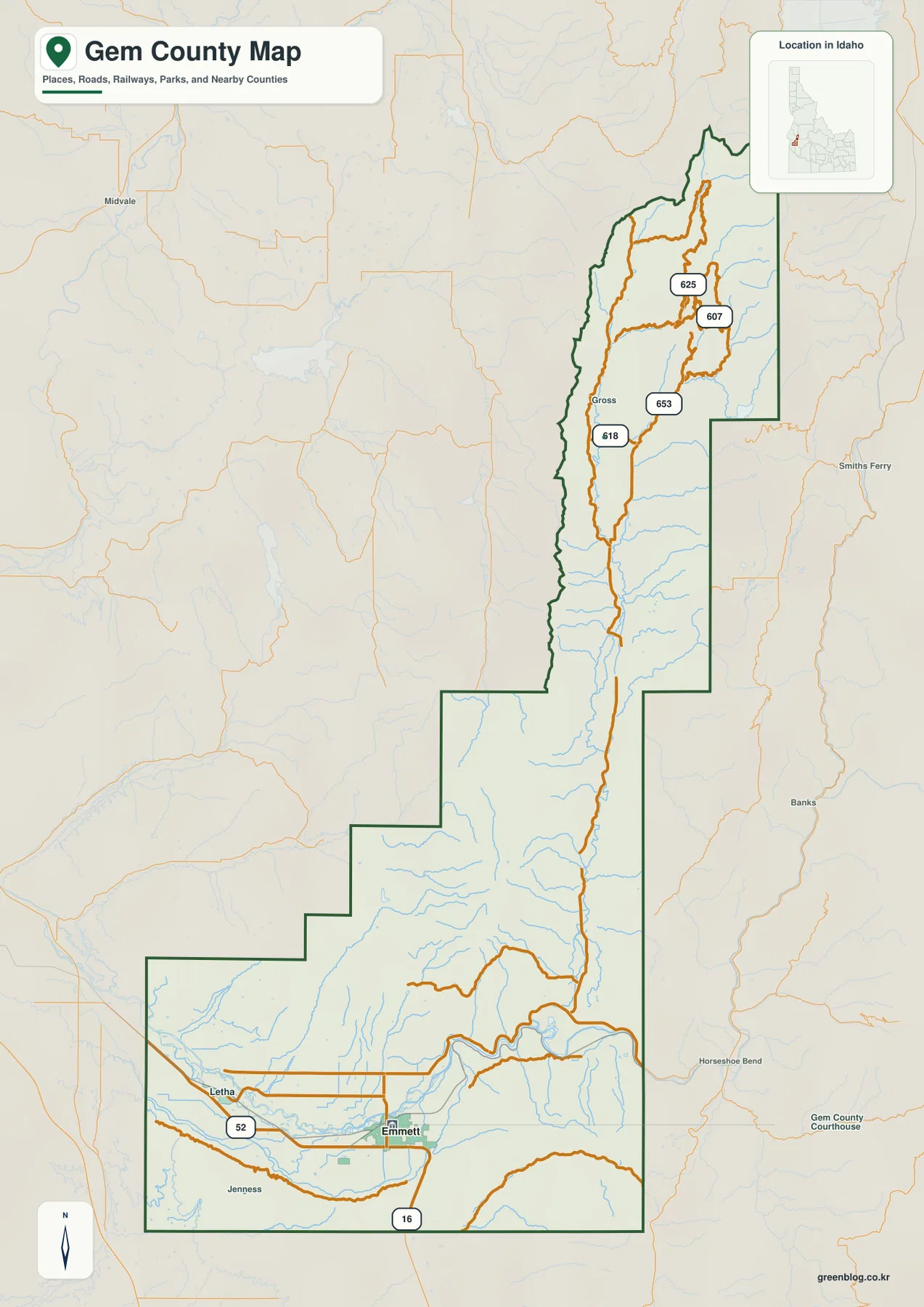
The general county map is the best place to begin because it combines the boundary with roads, water lines, and a small number of place labels. Emmett stands near the southern edge of the county, while Letha is labeled to the west. Idaho State Highway 16 approaches the Emmett area from the south, and Highway 52 crosses the western side of the lower valley. The road network is visibly denser here than it is in the upper part of Gem County, matching the heavier concentration of settlement and water infrastructure around the southern lowland.
The boundary changes character quickly north of the valley. The southern section is comparatively broad, then the county steps inward through its middle and continues north as a long, narrow strip. In the central and upper portions, numbered roads such as 618, 653, 625, and 607 remain visible even where familiar town names are sparse. Those route labels are useful for orientation because they show that travel corridors continue through the narrow northern section, but this is not a live traffic map and it does not report closures, travel times, or current road conditions.
The outline also helps explain why different neighboring counties appear around different parts of Gem County. On the accompanying city distribution view, Canyon and Payette counties lie to the southwest and west, Adams and Washington counties are shown toward the northwest and north, and Ada, Valley, and Boise counties appear along the eastern side. That regional context matters because the county reaches far beyond the Emmett area that many readers may know first.
Emmett is the only ranked major city shown on the supplied city map
The city distribution map is intentionally simple. Emmett is the one ranked major city identified in the supplied city index, and no second ranked city marker appears farther north. Instead of presenting a chain of urban centers, the map emphasizes how strongly the recognized city center is concentrated near the southern end. The rest of the county stretches a long distance north beyond that marker, making the relationship between the settled valley and the upper county immediately visible.
This simplicity is useful for orientation. The surrounding labels for Canyon, Payette, Adams, Washington, Ada, Valley, and Boise counties frame Gem County without adding a dense road layer. A reader who is familiar with the Boise area but not with Gem County can quickly see that Emmett is positioned in the lower part of the county, while the county itself reaches north into much more lightly labeled terrain. The map therefore answers a basic geographic question well: where is the principal city relative to the full county boundary?
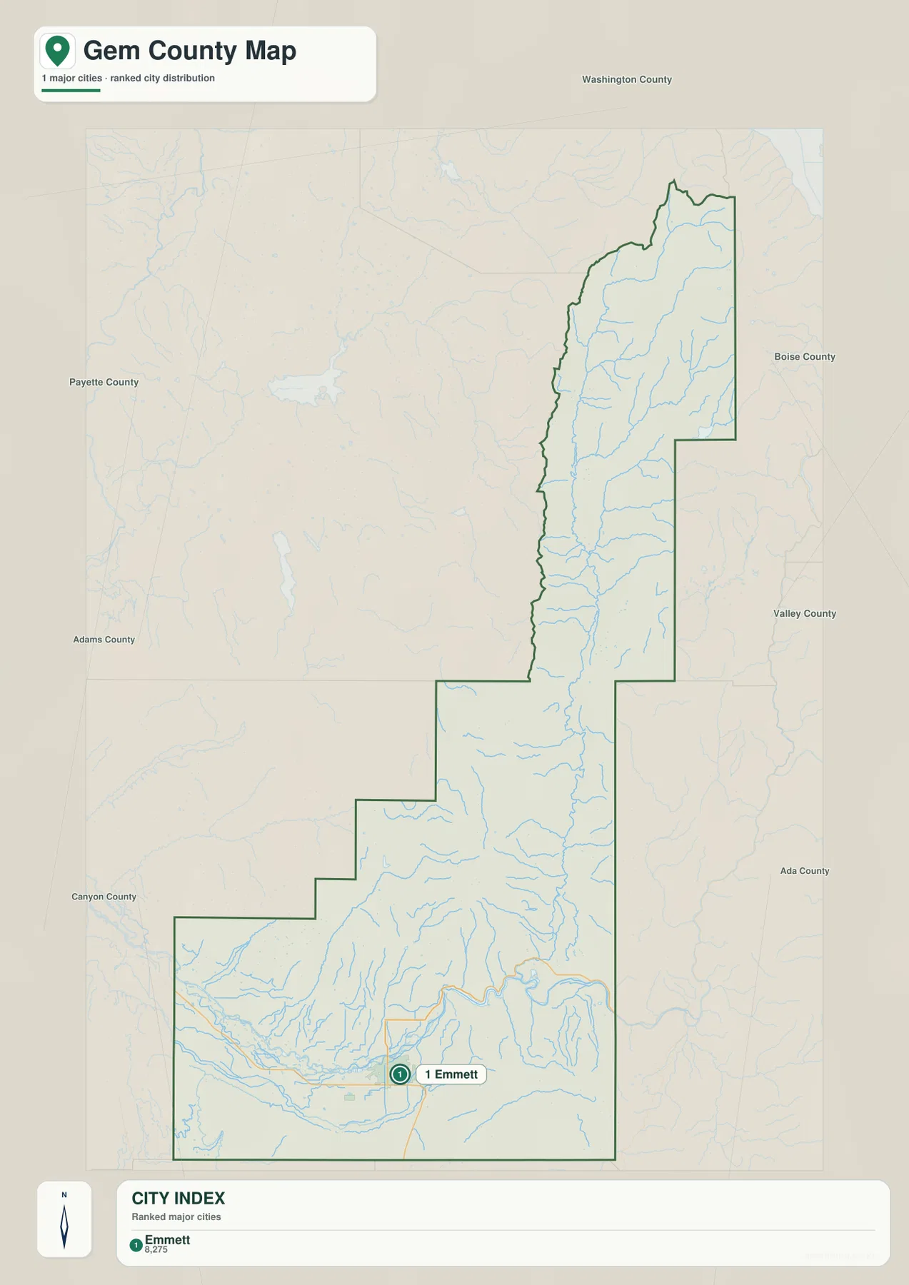
Because only one ranked city is shown, there are no city-to-city connector lines or intercity distance labels on this layer. That absence should not be filled with invented routes or distances. For actual driving directions, the general road map or a current navigation service is more appropriate. The city map is best used for identifying Emmett’s position and for seeing how much of the county lies north of the main urban marker.
The Payette River and Black Canyon Reservoir anchor the southern water network
Water features become much more detailed on the terrain-and-water map. The Payette River enters the lower county from the west and crosses the Emmett Valley. Black Canyon Reservoir is labeled northeast of Emmett on the same river. According to the U.S. Bureau of Reclamation material referenced in this package, Black Canyon Diversion Dam is on the Payette River about five miles northeast of Emmett and was constructed from 1922 to 1924. The project diverts water into the Black Canyon Canal, which helps explain why the river, reservoir, and canal names appear close together on the map.
The lower valley contains several managed water features in addition to the main river. Enterprise Canal, Farmers Cooperative Canal, Black Canyon Canal, Last Chance Ditch, and the City of Emmett Lagoon are all labeled around the southern part of the county. Their presence gives this section of the map a very different appearance from the upper county. The labels show where these features are located, but they should not be used to infer ownership, water rights, current operating schedules, or present flow conditions.
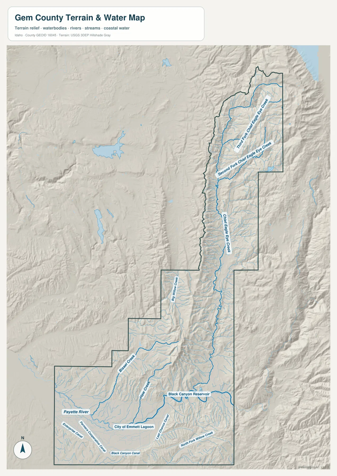
North of the Emmett area, named creeks replace canals as the dominant water labels. Big Willow Creek, Bissel Creek, and Hall Creek appear in the central and south-central portions. Farther up the county, Chief Eagle Eye Creek runs through a long valley, with Second Fork Chief Eagle Eye Creek and Third Fork Chief Eagle Eye Creek branching in the upper section. These names are easier to find on the water map than on the general county view, especially because shaded relief makes the valleys beneath the streams visible.
The map is a geographic reference rather than a regulatory or safety product. It does not contain flood hazard zones, parcel lines, water depth, boating routes, or real-time reservoir information. For current operations at Black Canyon Reservoir or official facility details, the Bureau of Reclamation source is the appropriate next step. Here, the value of the map is straightforward: it shows how the river, reservoir, canals, and mountain creeks are positioned relative to Emmett and the county boundary.
Elevation changes from low southern ground to high northern ridges
The elevation map makes the north-south contrast even clearer. Its legend reports an actual range of roughly 682 to 2,420 meters and a mean elevation of 1,086 meters. The Emmett and Payette River area is dominated by dark green tones representing the lowest parts of the county. Moving north, the terrain becomes more broken and the colors shift through lighter greens and yellows. Near the northern end, brown high-elevation terrain occupies a much larger share of the narrow county.
That color progression helps explain patterns visible on the other maps. The broad southern lowland has room for Emmett, major roads, the Payette River, and several canals to occupy the same general area. Through the middle of the county, the boundary narrows and the relief becomes more pronounced. In the upper section, roads and creeks follow elongated valleys between ridges rather than forming the denser network seen around Emmett. Switching between the water and elevation layers makes those relationships easier to see.
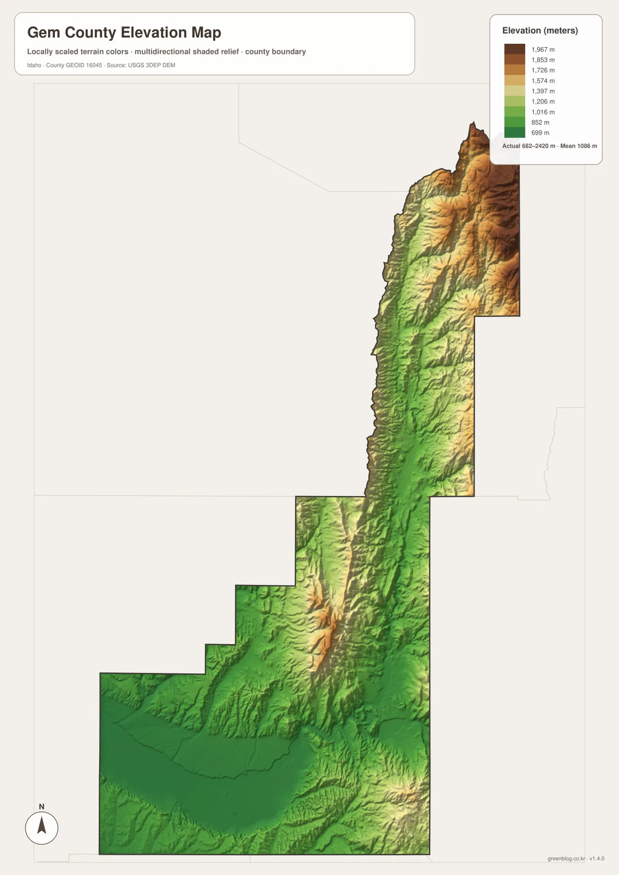
This elevation surface is generalized for county-scale comparison. It is useful for seeing where the broad lowland gives way to higher terrain, but it is not survey-grade data and should not be used to determine the exact elevation of a building, parcel, trail point, or construction site. Detailed field work, engineering, and surveying require the underlying USGS elevation products or another appropriate official source.
Roads, streams, and relief tell a different story in the south and north
Viewed together, the four maps describe two contrasting parts of one county. In the south, Emmett, Letha, Highways 16 and 52, the Payette River, Black Canyon Reservoir, and several canals are packed into a relatively compact area. That concentration makes the Emmett Valley the visually busiest part of the page. Northward, ranked-city labels disappear and the county becomes a much longer corridor of roads, tributary streams, valleys, and high ridges.
The central section acts as the transition between those settings. A road may look like the most important feature on the general map, but the terrain-and-water layer reveals nearby creeks and valley floors, while the elevation layer shows the ridges that separate them. No single map needs to carry every detail. The advantage of the set is that a reader can use the boundary map for orientation, then switch to the specialized layer that answers the next question.
Historical context reinforces the importance of the southern valley without changing what the maps themselves show. The Gem County Historical Society material referenced in the package notes that Gem County was established in 1915 from portions of Canyon and Boise counties, with Emmett serving as the county seat. That background helps explain why Emmett remains the obvious named center in the supplied city layer, while the modern maps show roads, canals, and the Payette River clustered around the same southern valley.
Choose the map that matches the question you are trying to answer
Use the general county map first when you need the clearest combination of boundary, roads, places, and basic waterways. It works well for locating Emmett and Letha, seeing where Highways 16 and 52 enter the lower county, and following road corridors toward the north. The city distribution map is a better choice when you want a cleaner view of Emmett’s position inside the full county outline and its relationship to surrounding counties.
Choose the terrain-and-water map when names such as the Payette River, Black Canyon Reservoir, Big Willow Creek, Bissel Creek, Hall Creek, or Chief Eagle Eye Creek matter. It also shows the lower-valley canal network more clearly than the other layers. Use the elevation map when the main question is topographic: where is the low southern valley, how quickly does the land rise, and where does the highest terrain become dominant? The strong green-to-brown gradient answers those questions more directly than a roads-and-places map can.
The WebP images embedded in the article are convenient for quick viewing, but the downloadable JPG originals are better for printing, presentations, worksheets, or closer inspection on a large screen. Each JPG measures 2572 by 3638 pixels and corresponds to one of the four map views described above. You can review the maps on the page first, decide which layer is useful for your project, and then download the ZIP for the full-size files.
Frequently Asked Questions
Which map should I use to see Emmett and Black Canyon Reservoir together?
Start with the general county map if you want Emmett, nearby roads, and the overall boundary in one view. Use the terrain-and-water map when the Payette River and Black Canyon Reservoir are the main focus. Comparing those two layers makes it easy to see Emmett in the southern valley and the reservoir northeast of the city on the Payette River.
Does the map show that northern Gem County is higher than the Emmett area?
Yes. The elevation layer shows the southern Emmett and Payette River area in the lowest green tones, with progressively higher yellow and brown terrain toward the north. The legend gives an actual range of about 682 to 2,420 meters and a mean of 1,086 meters. Those values are useful for county-wide comparison, not for precise elevation measurements at individual sites.
What is included in the downloadable ZIP?
The ZIP contains four high-resolution JPG files that correspond to the maps shown on this page: the county map, city map, terrain-and-water map, and elevation map. Each image is 2572 by 3638 pixels. The files are intended for readers who want a larger printable version than the WebP previews embedded in the article.
Sources and reference material
Boundary and base geography can be checked against the U.S. Census Bureau TIGER/Line Shapefiles. Water features can be referenced through USGS National Hydrography, while elevation data can be checked with the USGS 3D Elevation Program.
For local context, see the U.S. Bureau of Reclamation page for Black Canyon Diversion Dam and the Gem County Historical Society and Museum. Current county statistics are available from U.S. Census Bureau QuickFacts for Gem County, Idaho.
Map File Information
Download the high-resolution JPG originals that correspond to the Gem County maps shown on this page. The ZIP is the better choice for printing or for inspecting labels and terrain at a larger size than the WebP previews.
- Included Files: county map, city map, terrain-and-water map, and elevation map
- Printable Size: 2572×3638 pixels for each JPG
- File Type: ZIP containing 4 JPG images
Related Maps
Green Map creates custom-edited map images using open geographic data sources such as geoBoundaries, Natural Earth, OpenStreetMap, and government open data.
These maps are edited visual materials, not raw data files, and are provided for education, documents, presentations, and graphic reference.