Fannin County sits along the Oklahoma line in North Texas, with Bonham near the middle of the county’s main east-west settlement belt and the Red River tracing its irregular northern edge. The supplied maps make several contrasts easy to see: U.S. 82 links a chain of towns across the central part of the county, Bois d’Arc Lake forms a large water body east-northeast of Bonham, and the elevation surface rises noticeably toward the southwest and southern interior. High-resolution A3 JPG versions of the county, city, water, and elevation maps are available together in the ZIP download box below.
Rather than treating Fannin County as a single flat rural block, it helps to orient from three strong references. Bonham anchors the road network, the Red River marks the northern edge, and Bois d’Arc Lake dominates the eastern interior water pattern. Savoy and Ector lie west of Bonham, Honey Grove is well to the east, and Leonard and Trenton sit farther southwest. Those locations create a county with a clear central road corridor but much more dispersed settlement and terrain away from U.S. 82.
Table of Contents
Bonham and the U.S. 82 Road Spine
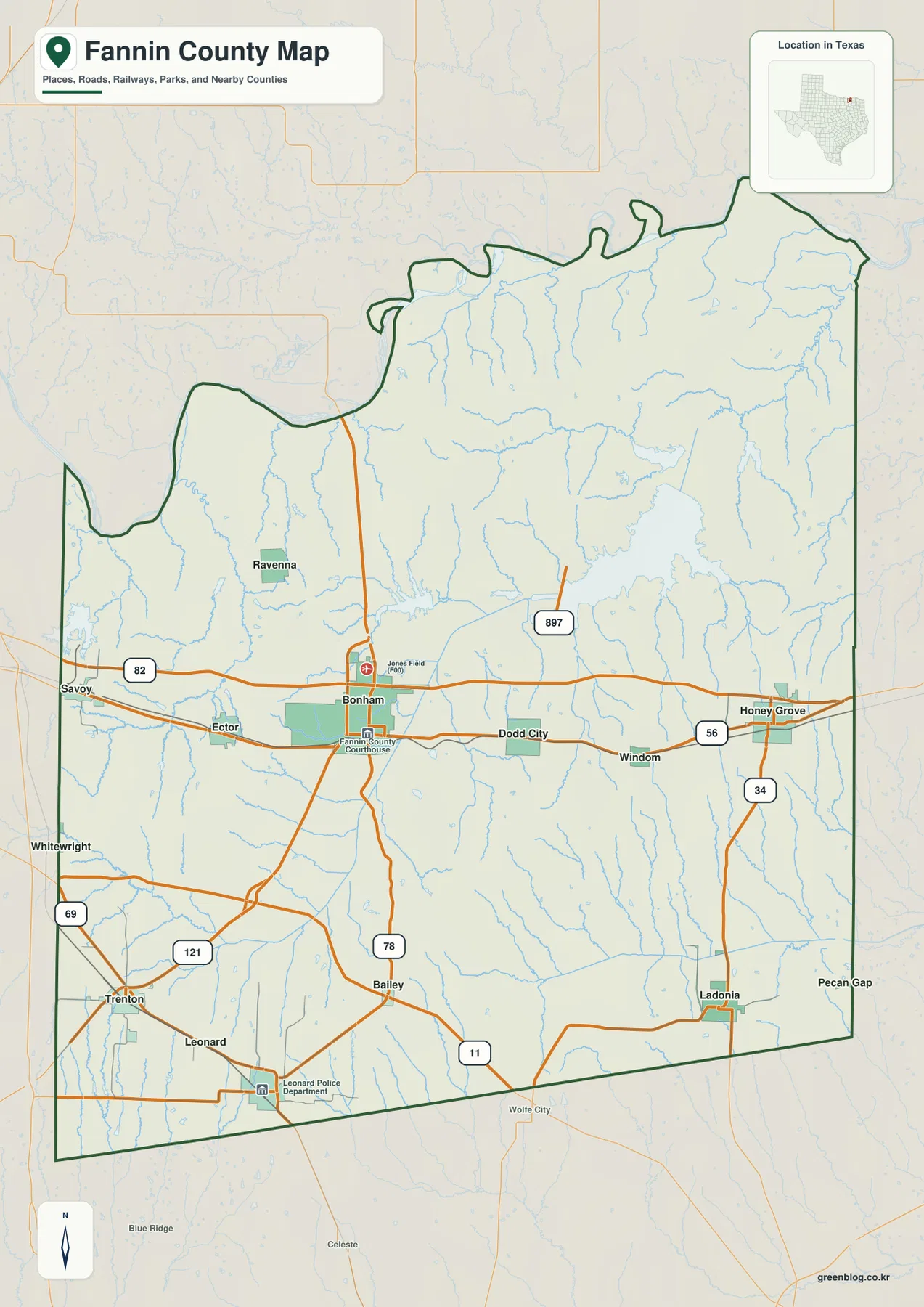
The general county map is the best place to understand how the main road system is organized. U.S. 82 runs west to east through Bonham, passing near Savoy and Ector on the west side and continuing toward Dodd City, Windom, and Honey Grove on the east. State Highway 121 approaches Bonham from the southwest, while State Highway 78 continues south from the city. Farther east, State Highway 56 reaches Honey Grove, and State Highway 34 turns south toward Ladonia. State Highway 11 crosses the southern part of the county near Bailey, creating a second east-west route away from the U.S. 82 corridor.
The county boundary adds another layer to the road pattern. The northern edge bends repeatedly because it follows the Red River, while much of the southern and eastern boundary is straighter. Savoy and Trenton sit close to the western side, and Honey Grove and Ladonia lie much nearer the east side. A practical way to orient yourself is to find Bonham first, follow U.S. 82 in both directions, and then trace the roads that branch south toward Leonard, Trenton, Bailey, and Ladonia.
What the Six-City Index Shows About Settlement
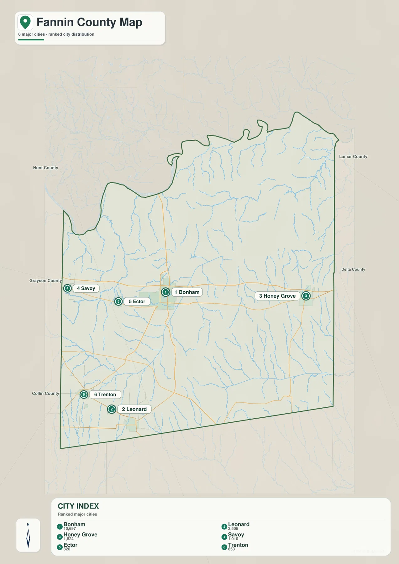
The city map highlights six places: Bonham, Leonard, Honey Grove, Savoy, Ector, and Trenton. Bonham is ranked first in the map’s city index, with Leonard and Honey Grove following it. The ranking is useful for seeing relative settlement size, but the geographic arrangement is even more revealing. Savoy and Ector are clustered west of Bonham along the broader U.S. 82 belt, while Leonard and Trenton are separated from that belt in the southwest. Honey Grove stands apart on the eastern side of the county.
This is not a connector-distance map, so it does not provide straight-line mile labels between Bonham and the other cities. Its strength is the uncluttered comparison of direction and spacing. Bonham is the central reference, Honey Grove is the clearest eastern center, and Leonard and Trenton define the southwest. If you need the actual driving route after identifying those positions, return to the county map and follow the numbered highways rather than estimating distance from the city-index graphic.
Red River, Bois d’Arc Lake, and the County’s Water Pattern
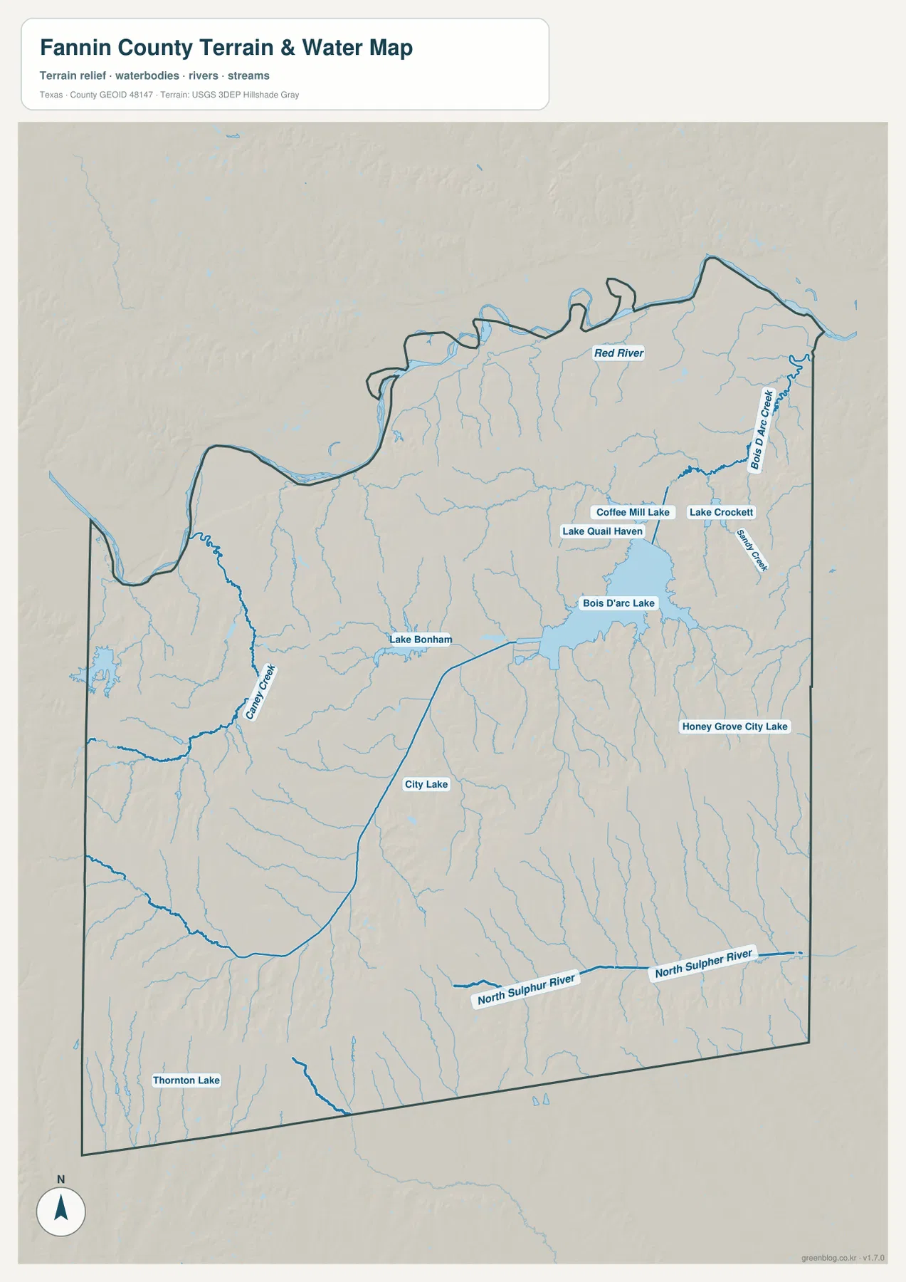
The water map changes the way the county looks. The Red River forms the broad northern reference and explains the winding top edge of the county. In the east-central area, Bois d’Arc Lake is the largest inland water body shown, with Bois d’Arc Creek extending toward the northeast. Lake Bonham lies to its west, and a cluster of smaller waters—including Coffee Mill Lake, Lake Crockett, and Lake Quail Haven—appears farther north and east. Honey Grove City Lake is marked closer to Honey Grove.
The southern drainage is organized differently. North Sulphur River crosses the southern part of Fannin County from west to east, while many smaller creeks descend through the interior. Gandy Creek is especially visible in the western half, and a dense network of unnamed or smaller tributaries feeds the larger channels. The result is a county where the northern river boundary, the large reservoir system in the east, and the southern river corridor are all distinct geographic zones rather than one continuous water feature.
Use this map to locate named rivers, creeks, reservoirs, and lakes relative to towns and roads. It is not a flood-hazard map, a property-boundary product, or a navigation chart, and it should not be used to infer water depth or legal shoreline limits. For ordinary map reading, however, it clearly shows why the eastern half of Fannin County feels more water-dominated than the road map alone suggests.
Lower Northern Valleys and Higher Southern Ridges
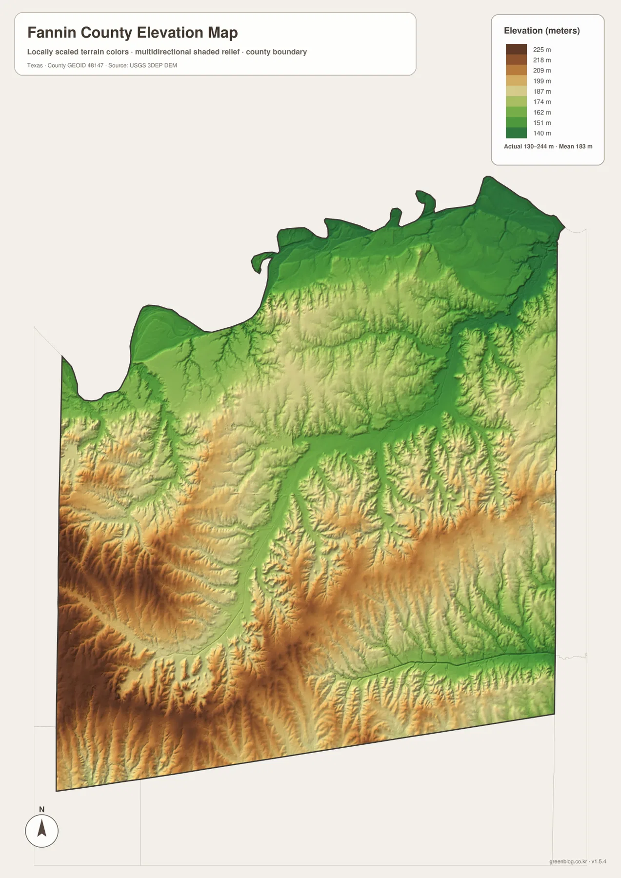
The elevation map shows an actual county range of about 130 to 244 meters, with a mean elevation of about 183 meters. The lowest broad areas appear along the Red River and across much of the northern edge, where green colors dominate. Lower ground also follows the Bois d’Arc Lake basin and several creek valleys that extend into the interior. In contrast, warmer yellow and brown colors spread across the southwest and parts of the southern interior, marking the county’s higher ridges and rolling uplands.
The transition between high and low ground is irregular because streams cut through the uplands. Narrow green valleys reach southward between higher ridges, while the large Bois d’Arc drainage creates a broader low corridor in the east-central area. Comparing the elevation and water maps side by side makes this relationship especially clear: many of the lowest bands correspond to river or creek valleys, while the more elevated terrain stands between those drainage lines. The colored elevation surface is generalized for county-scale reading and should not be treated as survey-grade elevation for engineering or parcel work.
Using Bonham, Bois d’Arc Lake, and Honey Grove as Reference Points
Three places make a useful framework for reading the county without reducing it to generic directions. Bonham is the road and civic anchor near the middle. Bois d’Arc Lake occupies a large part of the east-central interior and immediately identifies the major reservoir landscape. Honey Grove lies east of both Bonham and the lake’s western side, giving the eastern road network a clear community reference. Together they show how settlement, transportation, and water overlap in the part of the county where the map is busiest.
The southwest tells a different story. Leonard and Trenton lie away from the U.S. 82 town chain, and the elevation map shows more extensive higher terrain across the southwest and southern interior. Ector and Savoy remain much closer to the central east-west corridor. That contrast is useful when comparing two places that are both west of Bonham but connected to different parts of the road network. Moving between the county map and the elevation map helps separate a simple directional relationship from the physical character of the land around it.
Choosing the Best Map for a Specific Question
Choose the county map when you need roads, community names, and the boundary in one view. The city-index map is cleaner when the goal is to compare the positions and relative ranking of the six highlighted communities. For Red River, Bois d’Arc Lake, Lake Bonham, North Sulphur River, or smaller creeks, the water map provides the clearest labels. Use the elevation map when the question is about where the county is lower or higher, especially the contrast between the northern river zone and the southwest uplands.
The maps can also be paired without turning the page into a technical GIS exercise. A student studying Honey Grove might identify the town and SH 56 on the county map, look for nearby lakes and creeks on the water map, and then check the surrounding height pattern on the elevation map. Someone working with Bonham can do the same around U.S. 82, Lake Bonham, and the lower drainage corridors to the north and east. The downloadable files preserve these views at a much larger JPG size for printing or offline reference.
Frequently Asked Questions
What is the easiest way to orient yourself on a Fannin County map?
Start with Bonham and U.S. 82. Follow the highway west toward Savoy and Ector and east toward Honey Grove, then locate Leonard and Trenton to the southwest. Once those places are clear, add the Red River along the north and Bois d’Arc Lake in the east-central part of the county.
Where is Bois d’Arc Lake in relation to Bonham and Honey Grove?
On the supplied water map, Bois d’Arc Lake lies northeast of Bonham and northwest of Honey Grove. Lake Bonham is to its west, while Bois d’Arc Creek continues toward the northeast, making the reservoir the most prominent inland water feature in that part of the county.
Which parts of Fannin County are lower and higher?
The elevation map places much of the lowest terrain along the Red River and the northern and east-central drainage areas. Higher ground is more extensive in the southwest and southern interior. The map shows an overall range of about 130 to 244 meters and a mean near 183 meters.
Sources and Reference Data
- USGS The National Map Viewer — Official map viewer for terrain, hydrography, roads, and other geographic layers.
- USGS National Hydrography — Official reference for rivers, streams, lakes, and hydrographic data.
- USGS 3D Elevation Program — U.S. Geological Survey elevation and terrain data program.
- U.S. Census Bureau TIGER/Line Shapefiles — Official source for county boundaries, roads, and other base geographic features.
Map File Information
Download the Fannin County county map, city map, water map, and elevation map as high-resolution A3 JPG files. The ZIP contains the same map types shown on this page.
- File Type: JPG
Related Maps
- Rockwall County Texas map
- Red River County Texas map
- Rains County Texas map
- Van Zandt County Texas map
- Tarrant County Texas map
Green Map creates custom-edited map images using open geographic data sources such as geoBoundaries, Natural Earth, OpenStreetMap, and government open data.
These maps are edited visual materials, not raw data files, and are provided for education, documents, presentations, and graphic reference.