Fayette County is centered on La Grange, where several numbered highways converge near the Colorado River, while Schulenburg and Flatonia form a separate southern travel belt along Interstate 10. The maps on this page make that contrast easy to see and add two other layers that matter just as much: a dense network of creeks and reservoirs, and a terrain surface that ranges from low river valleys to much higher ridges. High-resolution A3 JPG versions of the county, city, water, and elevation maps are available together in the ZIP download box below for printing, classroom use, presentations, and offline reference.
A simple way to orient yourself is to begin at La Grange and then look outward. Plum is close to the west, Fayetteville and Ellinger lie to the east and southeast, and Round Top and Carmine occupy the northeastern part of the county. Farther south, Schulenburg and Flatonia sit near the I-10 and Route 90 corridor. The Colorado River bends through the middle of this arrangement before continuing toward the southeast, so roads, settlements, waterways, and elevation changes can be compared without reducing the county to a list of place names.
Table of Contents
The Highway Junction at La Grange and the Southern I-10 Belt
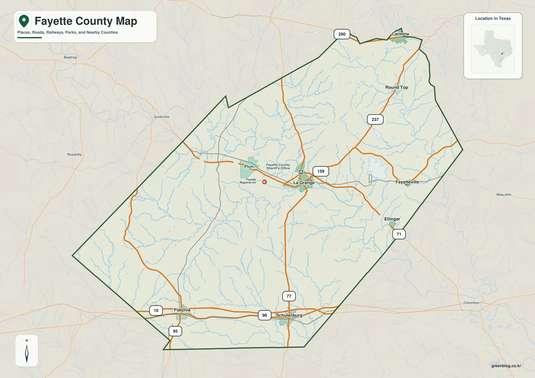
The general county map shows La Grange as the most obvious road junction. Route 77 runs north-south through the area, Route 159 heads east toward Fayetteville, and Route 237 reaches toward Round Top. Route 71 serves the southeastern side near Ellinger and provides another connection away from the county seat. West of La Grange, the road pattern becomes more dispersed around Plum and the rural western half of the county. This makes the center of the map busier than many of the outer areas even before the city labels are considered.
The southern part of Fayette County is organized around a different set of connections. Schulenburg and Flatonia sit along Interstate 10 and Route 90, creating a strong east-west corridor near the county’s lower edge. Route 95 crosses at Flatonia, while Route 77 connects the Schulenburg area back toward La Grange. Reading those routes together is more useful than treating each highway as an isolated line: the map shows a central network focused on La Grange and a southern corridor where through traffic and local town access overlap.
Six Highlighted Communities from La Grange to Carmine
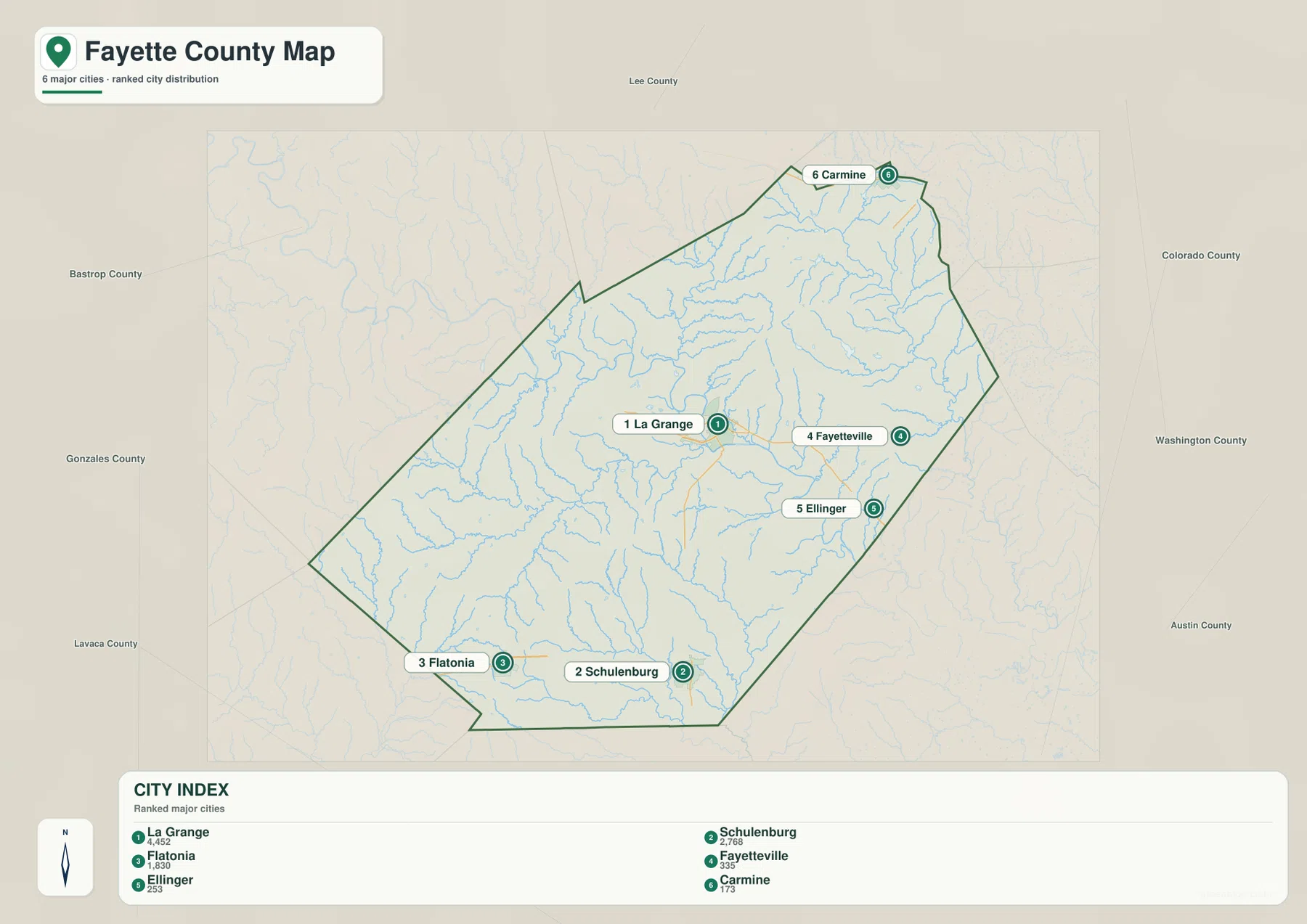
The city map highlights La Grange, Schulenburg, Flatonia, Fayetteville, Ellinger, and Carmine. The city index lists La Grange at 4,452, making it the largest of the six places shown. Schulenburg follows at 2,768 and Flatonia at 1,830. Fayetteville is listed at 353, Ellinger at 253, and Carmine at 173. These figures are useful because they show that the most substantial settlement is concentrated at La Grange and the two southern towns rather than being evenly distributed across the county.
The positions of the six places reinforce that pattern. La Grange lies slightly east of the county’s center, while Schulenburg and Flatonia are separated along the southern edge. Fayetteville and Ellinger sit east and southeast of La Grange, and Carmine is close to the northeastern tip. The county therefore does not have one continuous urban chain. Instead, the map shows a central civic center, a pair of larger southern towns along the interstate corridor, and smaller communities spread through the east and northeast.
Colorado River, Navidad Headwaters, and the Creek Network
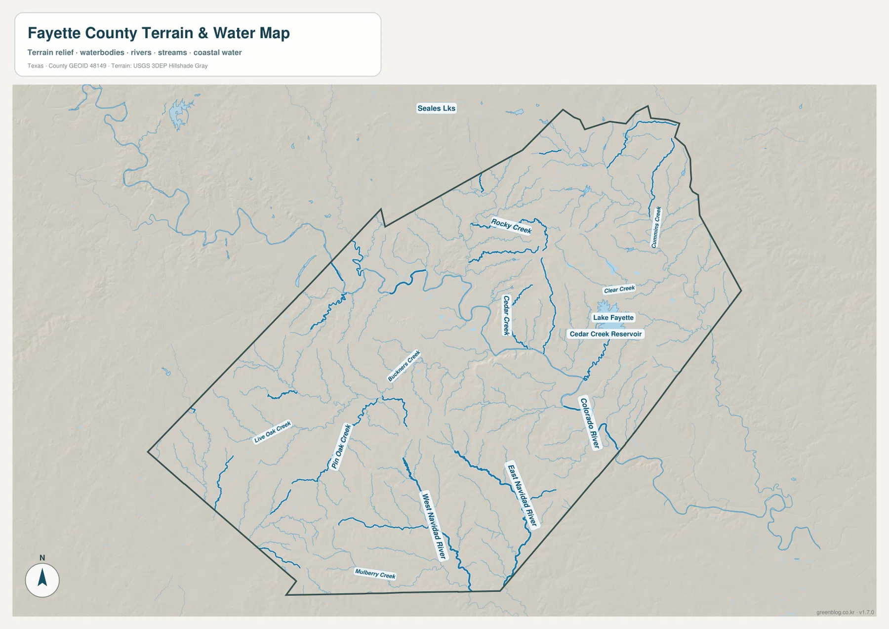
The water map gives Fayette County a very different appearance from the road map. The Colorado River is the strongest single feature, bending through the central part of the county near La Grange and continuing toward the southeast. Cedar Creek runs through the east-central interior, while Rocky Creek and Buckners Creek help define drainage in the central and western sections. Cummins Creek and Clear Creek are prominent farther northeast, where the terrain becomes more dissected around the Round Top and Carmine side of the county.
South of the Colorado River system, several waterways trend toward the Navidad drainage. West Navidad River and East Navidad River extend through the southern half, joined by smaller channels such as Pin Oak Creek and Live Oak Creek. Mulberry Creek appears near the southern edge. This means the county’s drainage cannot be summarized by the Colorado River alone. The central and eastern interior is strongly tied to the Colorado, while parts of the south drain through a different set of channels that cross the I-10 landscape around Schulenburg and Flatonia.
Reservoirs add another recognizable feature in the eastern half. Lake Fayette and Cedar Creek Reservoir appear close together east-northeast of La Grange and north of the lower Colorado River corridor. Seales Lakes is visible beyond the northern county edge. The water map is designed for locating rivers, creeks, and reservoirs relative to roads and towns; it does not show flood risk, water depth, legal shoreline boundaries, or navigation conditions. For ordinary geographic reference, however, it clearly separates the Colorado River valley from the smaller creek systems and southern drainage.
Low River Valleys Between Higher Northeastern and Southwestern Ridges
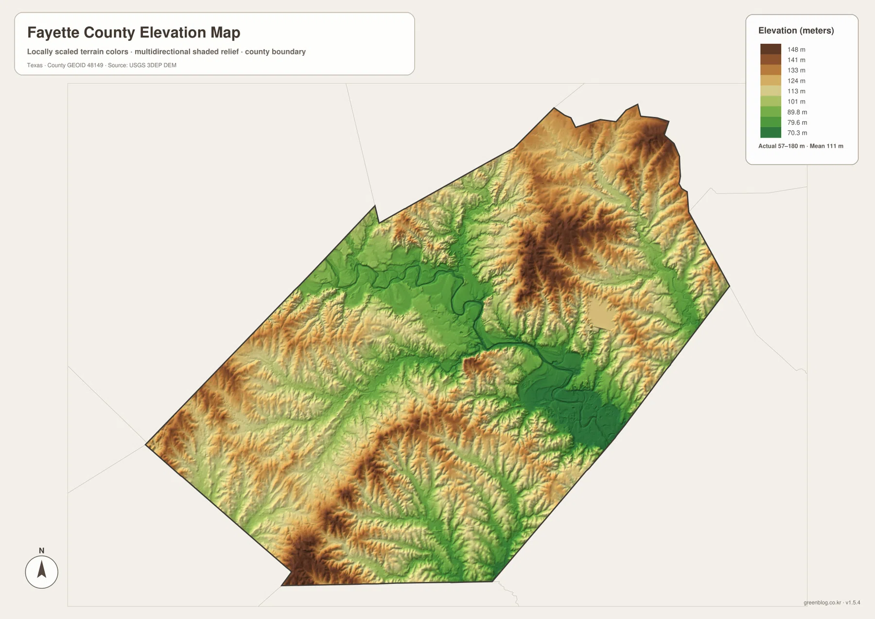
The elevation map shows an actual Fayette County range of about 57 to 180 meters, with a mean near 111 meters. The broadest low area follows the Colorado River through the center and southeast, where deep green shades mark the river valley and adjacent low ground. Elevation rises away from that corridor. Large areas in the northeast and east-central interior turn yellow, orange, and brown, and similar higher ridges appear in the southwest and along parts of the southern boundary.
The county seat sits close to one of those low corridors. La Grange is near the Colorado River valley, yet the land rises relatively quickly on either side of the river. Moving toward Fayetteville and Round Top, the surface is cut by repeated creek valleys and intervening ridges. The southwest toward Flatonia also contains higher ground broken by lower channels. Comparing the water and elevation maps makes the relationship easy to recognize: many green low bands follow the Colorado River or named creeks, while the warm-colored uplands occupy the ground between them.
This elevation surface is appropriate for county-scale comparison rather than parcel surveying or engineering. It is useful for seeing why the road and water maps do not sit on a perfectly flat landscape, and it helps explain the visible contrast between the central river valley and the rougher northeastern and southwestern terrain. Exact site elevations or construction decisions require more detailed source data.
Comparing La Grange, Fayetteville, and the Southern Towns
La Grange and Fayetteville are relatively close on the county map, but their surrounding features are not identical. La Grange is the main road junction and sits beside the Colorado River valley. Fayetteville lies east along Route 159 and is closer to Lake Fayette, Cedar Creek, and the more dissected northeastern terrain. Continuing toward Round Top and Carmine brings the road network into a landscape of more frequent creek valleys and higher ridges, which is much easier to recognize when the general and elevation maps are viewed together.
Schulenburg and Flatonia create a second comparison. Both towns are tied to Interstate 10 and Route 90 rather than the road concentration immediately around La Grange. The water map places West Navidad River, East Navidad River, and Pin Oak Creek across this southern part of the county, while the elevation map shows alternating ridges and low drainage lines. Looking at those features together gives the southern corridor a more specific geographic identity than simply calling it the I-10 side of Fayette County.
Choosing a Map for Roads, Water, or Terrain
Use the general county map when roads, community names, and the county boundary need to be visible together. The city map provides a cleaner comparison of the six highlighted communities and their relative size. The water map is the better choice for locating the Colorado River, Lake Fayette, Cedar Creek, and the Navidad drainage, while the elevation map makes the low river valleys and higher ridges much easier to distinguish.
The maps also work well as a sequence. Around La Grange, identify Routes 77 and 159 first, move to the water map to locate the Colorado River and Cedar Creek, and then compare the same area on the elevation surface. Around Schulenburg or Flatonia, start with Interstate 10 and Route 90 before checking the Navidad waterways and southern ridge pattern. This keeps the page focused on visible county-specific relationships rather than generic map-reading advice.
The WebP images on the page are optimized for quick viewing. The ZIP below contains high-resolution A3 JPG files of the county, city, water, and elevation maps for larger printing, classroom handouts, presentations, or offline reference. You can use only the map type you need or keep the full set together for comparison.
Frequently Asked Questions
What is the easiest way to orient yourself on a Fayette County map?
Start with La Grange and the roads that meet there, especially Routes 77, 159, 71, and 237. Then locate Schulenburg and Flatonia along the southern I-10 corridor and trace the Colorado River from the La Grange area toward the southeast. Those references establish the main settlement, road, and water relationships quickly.
Which waterways stand out besides the Colorado River?
Cedar Creek, Rocky Creek, Cummins Creek, and several other creeks are prominent in the central and northeastern parts of the county. In the south, West Navidad River and East Navidad River are major labeled channels. Lake Fayette and Cedar Creek Reservoir also stand out in the eastern interior.
Where are the lower and higher parts of Fayette County?
The broadest low terrain follows the Colorado River valley through the center and southeast. Higher ridges are more extensive in the northeast, east-central interior, southwest, and parts of the southern edge. The supplied elevation map shows an actual range of about 57 to 180 meters with a mean near 111 meters.
Sources and Reference Data
- USGS The National Map Viewer — Official map viewer for county boundaries, roads, hydrography, and terrain layers.
- USGS National Hydrography — Official reference for rivers, streams, lakes, reservoirs, and hydrographic data.
- USGS 3D Elevation Program — U.S. Geological Survey program for elevation and terrain data.
- U.S. Census Bureau TIGER/Line Shapefiles — Official geographic source for county boundaries, roads, and related base features.
Map File Information
Download the Fayette County county map, city map, water map, and elevation map as high-resolution A3 JPG files. The ZIP contains the same map types shown on this page.
- File Type: JPG
Related Maps
- Austin County Texas map
- Bastrop County Texas map
- Washington County Texas map
- Travis County Texas map
- Wharton County Texas map
Green Map creates custom-edited map images using open geographic data sources such as geoBoundaries, Natural Earth, OpenStreetMap, and government open data.
These maps are edited visual materials, not raw data files, and are provided for education, documents, presentations, and graphic reference.