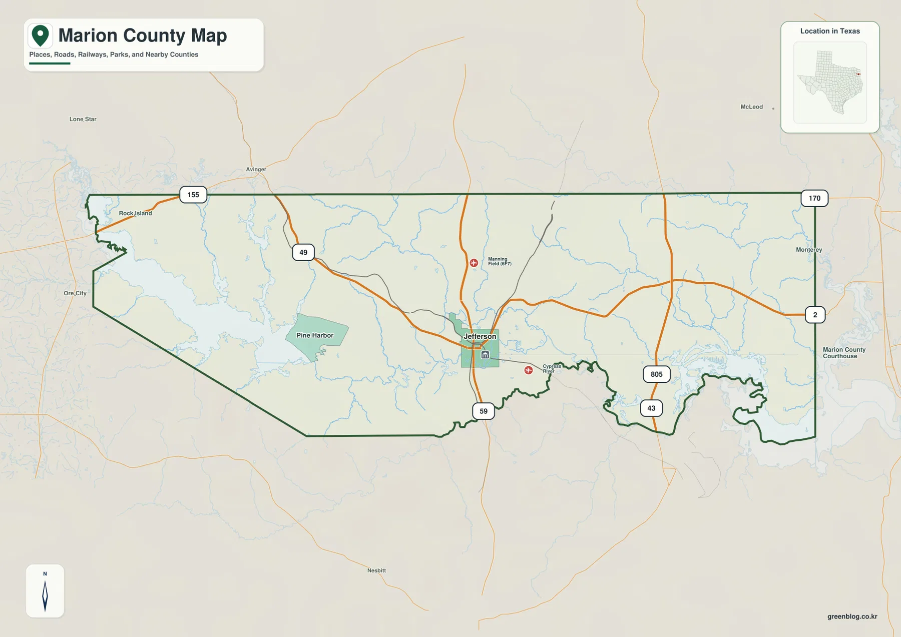
You can download four high-resolution A3 JPG maps of Marion County, Texas, in one ZIP directly from this page. The package includes a general county map, a ranked city map, a terrain-and-water map, and an elevation map. Together they show Jefferson, roads marked 49, 59, 155, 170, 2, 805, and 43, Lake O’ the Pines, the Big Cypress drainage, eastern bayous and lakes, and an actual elevation range of about 50 to 160 meters.
Jefferson is the easiest place to begin because it sits near the middle-south part of the county and is clearly marked on the road map. Route 59 runs south from the city, while Route 49 approaches from the northwest. The road pattern is useful for basic orientation, but Marion County becomes much more distinctive when the water layer is added. Lake O’ the Pines occupies the west, Black Cypress Bayou and Big Cypress Creek cross the middle, and a dense complex of bayous and lakes fills the eastern side toward the Caddo Lake region.
Table of Contents
Jefferson ties the central road network together
Jefferson is the strongest settlement label on the general county map. The town appears slightly south of center with a courthouse symbol nearby, giving the administrative area an easy visual reference. Route 59 passes the city and continues south, while Route 49 comes in from the northwest. Those two roads provide the simplest framework for locating Jefferson before moving to the more complicated water features.
Manning Field is labeled north of Jefferson, and a Cypress-related river label appears just southeast of the town. Pine Harbor is shown farther west beside the large Lake O’ the Pines water body. Route 155 reaches the northwestern edge, while routes 170 and 2 form a useful north-south reference near the eastern boundary. Routes 805 and 43 are visible farther south and southeast, close to the most irregular part of the county outline.
The east and west sides look very different. West of Jefferson, roads and the large reservoir provide clear visual anchors. East of town, the boundary becomes increasingly shaped by water and winding channels. That difference is important because the county cannot be understood as a simple road grid around Jefferson; the waterways define much of the eastern landscape and influence the outline itself.
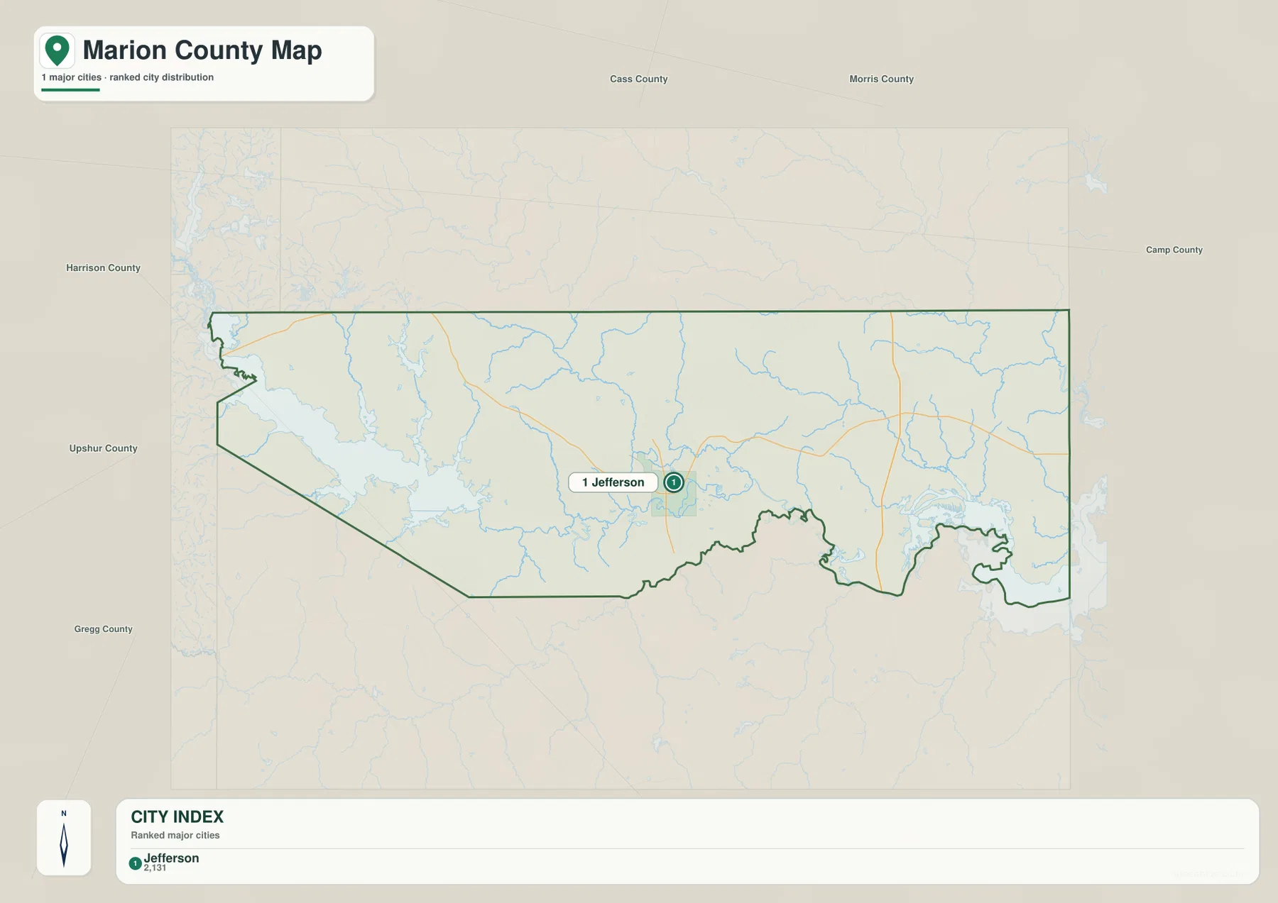
The city index highlights Jefferson as the single ranked major city
The ranked city map contains one major-city marker: Jefferson is number 1. The lower index also prints the value 2,131 beside the name. The supplied image does not identify a date for that figure, so this article treats it only as a value shown in the map index rather than presenting it as a confirmed current population count.
The simplified view makes Jefferson’s position especially clear. The city sits in the lower middle of the county, with a large water body to the west and an increasingly complex drainage landscape to the east and southeast. Because no other major city is ranked on this map, settlement distribution is less important here than the relationship between Jefferson and the surrounding water network.
Cass, Morris, Camp, Harrison, Upshur, and Gregg counties are labeled around the outside for regional orientation. The city map is useful when a quick Jefferson locator is needed. The general map provides the fuller road picture, and the water map is essential for understanding why the east side of Marion County looks so different from the west.
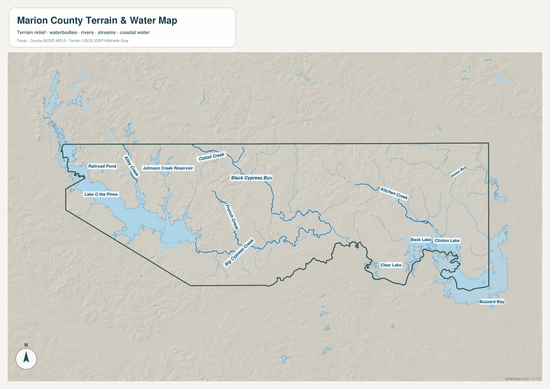
Lake O’ the Pines and Johnson Creek Reservoir define the western water landscape
On the terrain-and-water map, Lake O’ the Pines is the most obvious western water body. It occupies a broad area near the county boundary, with Pine Harbor shown nearby on the road map. Johnson Creek Reservoir is labeled farther north, and Railroad Pond appears near the northwestern edge. Together these features make the western side easy to identify even when road labels are removed.
Several named creeks feed the western and central drainage. Alley Creek runs near the large reservoir, while Cattail Creek appears farther east. The terrain shading shows these channels occupying narrow valleys among higher ridges. The west is therefore not simply a reservoir beside flat land; it is a dissected upland-and-water setting with multiple tributaries entering larger water bodies.
Big Cypress waters connect Jefferson to the lake-and-bayou country in the east
Black Cypress Bayou is one of the most prominent named channels near the central part of the water map. Big Cypress Creek runs through the lower middle, and French Creek approaches the same broader drainage from the north. These waterways occupy lower, greener terrain on the elevation map and form a physical connection between the Jefferson area and the more complex eastern waters.
Farther east, Kitchen Creek and James Bayou become important named references. Near the southeastern side, Back Lake, Clinton Lake, and Clear Lake are labeled close together. Buzzard Bay appears farther south. This dense lake-and-bayou landscape forms the eastern water environment associated with the package’s Caddo Lake theme, and it looks very different from the single broad reservoir on the west.
The water map is intended for geographic reference. It is useful for locating named creeks, bayous, lakes, reservoirs, and broad water areas relative to Jefferson and the county boundary, but it is not a flood-hazard map, parcel map, legal water-boundary product, or navigation chart. When a road number or settlement is needed, the same location should be matched back to the general map.
Western hills stand above the low eastern bayou and lake country
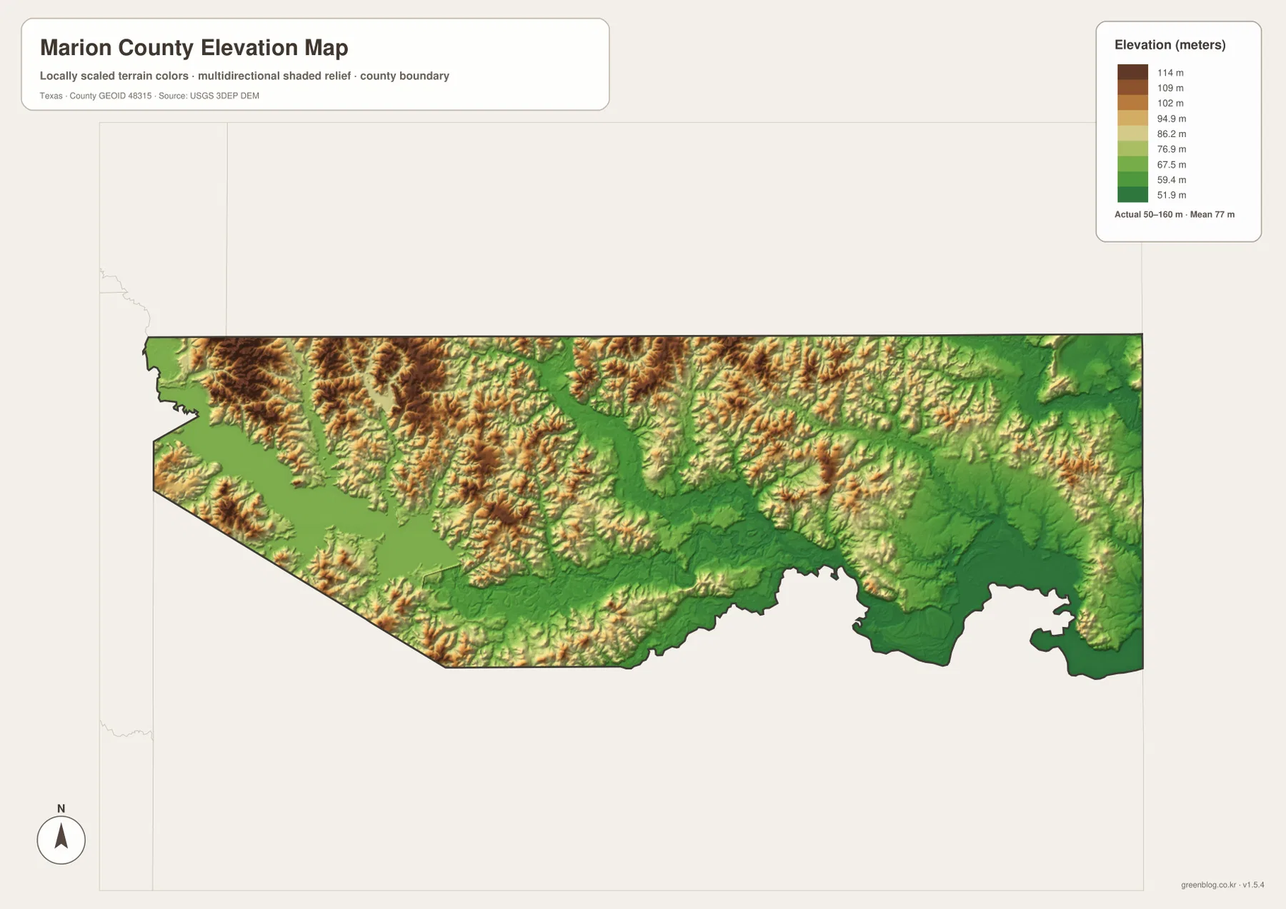
The elevation map reports an actual range of about 50 to 160 meters and a mean elevation of about 77 meters. Browns and tans dominate much of the west and northwest, where the higher hills are concentrated. Green colors spread more broadly through the middle and east, especially along the major drainage corridors and the lake-rich southeastern side.
The western hills are strongly dissected rather than smooth. Narrow green valleys cut through higher ridges and lead toward Lake O’ the Pines and the central creek network. Big Cypress waters occupy another lower corridor through the middle of the county. This makes the shaded relief look much more textured than the general road map.
The eastern side is lower overall, though small hills remain within the broad green lowlands. Back Lake, Clinton Lake, Clear Lake, James Bayou, and the Caddo Lake-side waters occupy terrain that is generally lower than the western uplands. The displayed difference between minimum and maximum elevation is about 110 meters, enough to create a clear west-to-east contrast without producing a mountain landscape.
The elevation layer is best used for relative terrain comparison rather than survey-grade or engineering-grade measurement. When matched with the water map, it shows why the major bayous and lakes occupy broad low corridors and why the western part of the county contains more pronounced ridges between streams.
Comparing both sides of Jefferson reveals the county’s strongest geographic contrast
From Jefferson, the western side can be followed toward Route 49, Pine Harbor, and Lake O’ the Pines. On the water map, that same area contains the reservoir, Johnson Creek Reservoir, Alley Creek, and other tributaries. The elevation view adds higher hills around the water, giving the west a clear upland-reservoir character.
Moving east from Jefferson produces a different sequence. Roads become less visually dominant, Black Cypress Bayou and Big Cypress Creek lead into a denser water network, and the southeastern map fills with lakes and bayous. The elevation layer becomes greener in the same direction. Looking at these maps together provides a more specific picture of Marion County than simply describing Jefferson and Caddo Lake as two isolated names.
Use the city map for a quick Jefferson locator, the general map for roads and surrounding place references, the terrain-and-water map for named bayous, creeks, lakes, and reservoirs, and the elevation map for the west-to-east relief difference. Smaller labels are often easier to inspect in the downloadable high-resolution JPG files than in the browser previews.
Frequently Asked Questions
Which city is highlighted on the Marion County city map?
Jefferson is the single ranked major city on the supplied city map. It lies slightly south of the county center and is easy to locate on the general map near routes 49 and 59. The city index also prints 2,131, but no date is shown, so this article does not present that value as a confirmed current population count.
Which water features stand out most clearly?
Lake O’ the Pines and Johnson Creek Reservoir are major western references. Black Cypress Bayou and Big Cypress Creek organize the central drainage, while Kitchen Creek, James Bayou, Back Lake, Clinton Lake, Clear Lake, and Buzzard Bay mark the complex eastern water landscape associated with the Caddo Lake area.
What elevation range is shown for Marion County?
The supplied elevation map reports an actual range of about 50 to 160 meters and a mean of about 77 meters. The west and northwest are generally higher, while the Big Cypress drainage and eastern lake-and-bayou areas are lower.
Sources and Reference Data
- U.S. Census Bureau TIGER/Line Shapefiles — official county-boundary and road geometry for geographic reference.
- USGS National Hydrography — official resources for bayous, creeks, lakes, reservoirs, and other water features.
- USGS 3D Elevation Program — official elevation resources used for terrain information.
- USGS The National Map Viewer — an official viewer for comparing geographic layers.
Map File Information
Download four high-resolution A3 JPG maps of Marion County, Texas, in one ZIP file.
- Included Files: county map, ranked city map, terrain and water map, elevation map
- File Type: JPG
Related Maps
- Morris County Texas map
- Upshur County Texas map
- Panola County Texas map
- Rusk County Texas map
- Red River County Texas map
Green Map creates custom-edited map images using open geographic data sources such as geoBoundaries, Natural Earth, OpenStreetMap, and government open data.
These maps are edited visual materials, not raw data files, and are provided for education, documents, presentations, and graphic reference.