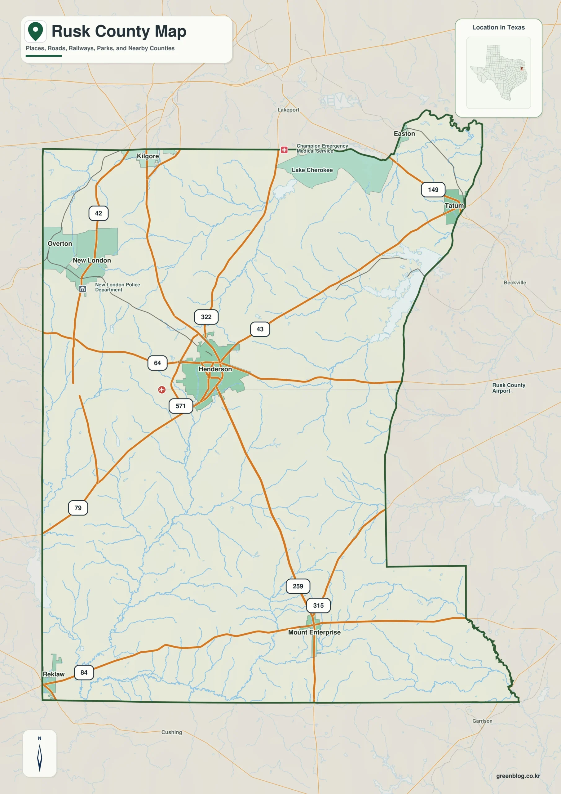
Henderson, oil-boom communities, pine forests, and a power-plant reservoir all occupy different parts of this East Texas county. This Rusk County Texas map identifies the county seat and places Overton, New London, Tatum, and Mount Enterprise within a border shared by seven neighboring counties. The 2024 population estimate was 53,391, a modest increase from 52,254 in 2020.
Rusk County contains about 924.20 square miles of land and 14.37 square miles of water. Its size allows the central courthouse town, northern oilfield corridor, northeastern lake district, and southern highway communities to remain geographically distinct. The three downloadable versions emphasize those relationships through color separation, monochrome labeling, or an empty boundary base.
Table of Contents
From a Republic-era county to a smaller modern boundary
The Republic of Texas created Rusk County from Nacogdoches County on January 16, 1843. It was named for Thomas Jefferson Rusk, who served as secretary of war under Sam Houston. Commissioners selected a central county-seat site, and land donations helped establish Henderson, named for future governor James Pinckney Henderson.
The original county extended farther north than it does today. In 1874, a large northern section became part of the newly organized Gregg County, removing roughly 284 square miles from Rusk County. The resulting map explains why Overton and the northwestern communities sit close to a county line that separates related railroad and oilfield settlements.
Oil transformed the western and northern communities
The county’s best-known economic turning point began with the Daisy Bradford No. 3 well in 1930. Columbus “Dad” Joiner’s discovery opened the East Texas oilfield, which later proved to extend through western Rusk County and parts of Gregg, Smith, Cherokee, Upshur, and other nearby areas. Drilling crews, speculators, pipelines, service companies, and new residents rapidly changed a landscape that had long depended on farming and timber.
Henderson became a business and legal center for the boom, while Overton gained importance as a railroad-linked oil town. New London, Joinerville, Turnertown, and Carlisle grew within the producing district, creating a chain of settlements unlike the quieter southern portion of the county. The contrast between these areas is one reason a county map is useful for understanding local history rather than treating the oilfield as a single point.
Roads, towns, and the county’s internal orientation
U.S. Highway 259 gives Rusk County a strong north-south axis. It passes through Henderson and continues toward Mount Enterprise, connecting the county seat with southern East Texas. State routes lead northwest toward Overton and New London, northeast toward Tatum, and east toward the Panola County side, so Henderson functions as the practical center of a multi-directional road network.
The towns do not form one continuous urban area. Overton lies near the Gregg County boundary, Tatum occupies the northeastern sector close to Harrison and Panola counties, and Mount Enterprise anchors the southern corridor. A Rusk County Texas map helps separate those travel directions while showing why county services, historic sites, and local destinations are often described in relation to Henderson.
Martin Creek Lake and the Piney Woods setting
The northeastern part of the county has a different visual character from the historic oil belt. Martin Creek Lake covers about 5,000 acres southwest of Tatum and was built to supply cooling water for electric generation. Martin Creek Lake State Park occupies 286 acres along the shore and has operated since 1976, adding camping, fishing, trails, and lake access to the county’s industrial landscape.
Beyond the reservoir, Rusk County belongs to the East Texas Piney Woods. Forest cover, creeks, rolling ground, and dispersed rural roads shape the spaces between communities. The lake and wooded terrain are therefore useful geographic anchors when reading the map: Tatum sits near the water in the northeast, while Henderson and the historic producing areas lie farther west.
Color Map
The color edition separates Rusk County from Gregg, Harrison, Panola, Shelby, Nacogdoches, Cherokee, and Smith counties, making the seven-county border pattern easy to follow. Henderson appears near the center, with Overton and New London toward the northern oilfield corridor and Tatum near Martin Creek Lake in the northeast. Mount Enterprise provides a southern reference along U.S. 259. These named points show how industry, water, and transportation occupy different sectors of the county rather than clustering in one location.

Black-and-White Map
The monochrome version removes area fills but keeps the county outline, internal linework, and selected place labels. Henderson remains the central reference, while the northwestern position of Overton and the northeastern position of Tatum can still be compared clearly. It is suited to reports, classroom handouts, or print layouts in which colored county fills would compete with surrounding text.

Outline Map
The outline file removes both color and place names, leaving the Rusk County boundary and the included internal divisions. Users can add Henderson and New London, trace the U.S. 259 corridor, or mark the Daisy Bradford discovery area and Martin Creek Lake. The open base also provides room to label Gregg and Cherokee counties or draw a route between Tatum, Overton, and Mount Enterprise.

Download the Rusk County map files
Each A3 JPG serves a different purpose: regional comparison in color, clean grayscale printing, or a customizable blank boundary map. The labeled editions preserve selected community names, while the outline edition is designed for new annotations.
County Map File Information
The download contains color, black-and-white, and outline maps of Rusk County. Selected place names appear in the first two versions, while the outline file removes labels and fills for custom work.
- Included Versions: Color, Black and White, Outline
- File Type: JPG
- Printable Size: A3 high-resolution layout
- Map Detail: County boundary, included local boundaries, and surrounding county reference
- Intended Use: Printing, lessons, presentations, documents, historical diagrams, and route annotations
Frequently Asked Questions
What natural feature is closest to Tatum?
Martin Creek Lake lies southwest of Tatum in northeastern Rusk County. The state park occupies part of the shoreline and provides public access for camping, trails, boating, and fishing.
Did the East Texas oilfield begin in Rusk County?
Yes. The 1930 Daisy Bradford No. 3 discovery in Rusk County opened the East Texas oilfield. Production later spread across a much larger multi-county area.
Which map version is best for marking historic sites?
The outline version offers the most open space. It can be used to add Henderson, New London, the oil-discovery area, Martin Creek Lake, highways, or individual historic communities without covering existing labels.
Sources and official references
- Handbook of Texas: Rusk County — A detailed account of county formation, boundary changes, agriculture, railroads, and the East Texas oil boom.
- U.S. Census Bureau QuickFacts — Federal population and geographic statistics for counties and states.
- Texas Parks and Wildlife: Martin Creek Lake State Park History — Official information about the lake, park acreage, opening date, and local setting.
Related Maps
- Willacy County Texas map|Raymondville, Port Mansfield, and Laguna Madre
- Van Zandt County Texas map|Canton, Grand Saline, Van, and Lake Tawakoni
- Titus County Texas map|Mount Pleasant, Pine Country, and Two Lakes
- Sabine County Texas map|Hemphill, Toledo Bend Shoreline, and Pine Forest Communities
- Waller County Texas map|Hempstead, Prairie View, and the Brazos River
Green Map creates custom-edited map images using open geographic data sources such as geoBoundaries, Natural Earth, OpenStreetMap, and government open data.
These maps are edited visual materials, not raw data files, and are provided for education, documents, presentations, and graphic reference.