Henderson County, Texas is organized around Athens in the middle of the county, a cluster of communities around Cedar Creek Reservoir in the west, and more separated towns toward the east. The supplied county, city, water, and elevation maps make those differences easy to compare. You can download the same map set as A3 high-resolution JPG files in a single ZIP archive from the download box below.
Athens is the clearest central reference on the general map. Route markers 175, 31, 7, 317, and 19 meet or pass close to the city, while Malakoff and Trinidad lie to the west and Poynor and Coffee City sit farther southeast. Around Cedar Creek Reservoir, Gun Barrel City, Tool, Seven Points, Mabank, and Payne Springs form a more concentrated western group than the communities shown on the eastern side.
Water and relief create another strong contrast. Cedar Creek Reservoir is the dominant body of water on the western side, while Caney Creek, Walnut Creek, Kickapoo Creek, and many smaller drainage lines cross the interior. The elevation legend shows an actual range of about 72 to 234 meters with a mean near 124 meters, with lower ground around the western reservoir and more pronounced high ground through the central-east and northeast.
Table of Contents
Athens anchors a road network that reaches the reservoir and eastern towns
On the general county map, Athens sits near the center of several numbered routes. Route 175 approaches from the west and continues toward the northeast, while 31 links the Malakoff side with Athens and the eastern part of the county. Markers 7 and 317 appear close to Athens, and 19 runs south from the central area, making the city a useful starting point for locating almost any other place on the map.
West of Athens, Malakoff and Trinidad lead toward the Cedar Creek Reservoir area. Farther northwest, Tool, Gun Barrel City, Seven Points, Mabank, and Payne Springs appear relatively close together around the large reservoir. The eastern side has a different spacing: Brownsboro and Chandler are separated across the northeast, while Poynor and Coffee City sit farther south and southeast.
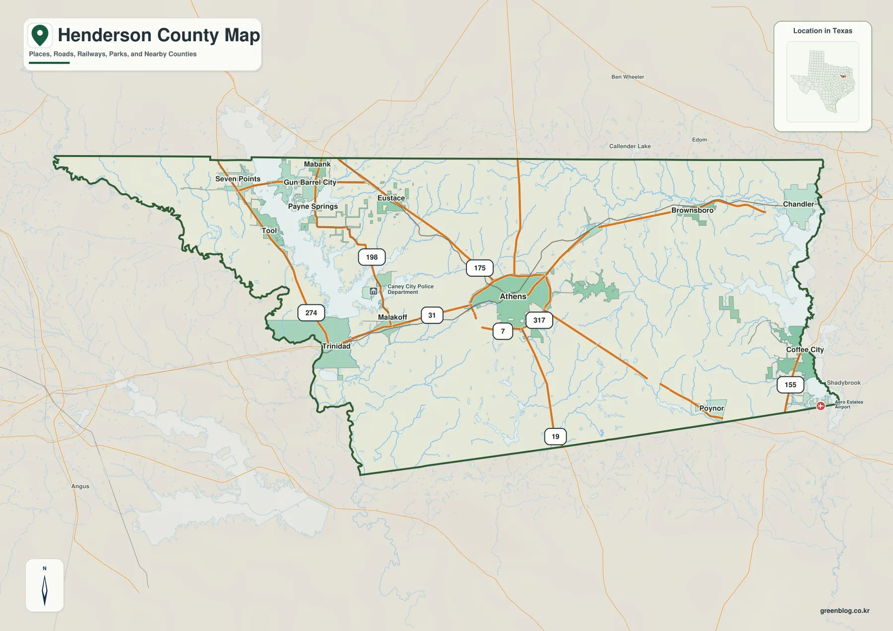
Several other route numbers help with orientation. Route 198 is marked across the northwestern and west-central side, 274 runs near the western reservoir communities, and 155 appears near Coffee City in the southeast. These labels are most useful as geographic reference points rather than as a complete transportation inventory; together with the town names, they show how the county is connected from the reservoir to the eastern boundary.
The ranked city map shows a central anchor and a separate northwest cluster
The city-distribution map ranks six major places. Athens is number 1 with a displayed value of 13,200. Gun Barrel City is number 2 at 6,570, and Chandler is number 3 at 3,518. Their positions are as important as the numbers: Athens is near the middle, Gun Barrel City is in the northwest reservoir area, and Chandler is close to the eastern boundary.
Tool is ranked number 4 at 2,367, Malakoff number 5 at 2,045, and Brownsboro number 6 at 1,658. Tool sits near Gun Barrel City, while Malakoff lies farther south and Brownsboro occupies the northeast. The values are useful for comparing the labels supplied on this map, but they should not be treated as a substitute for a current official population table.
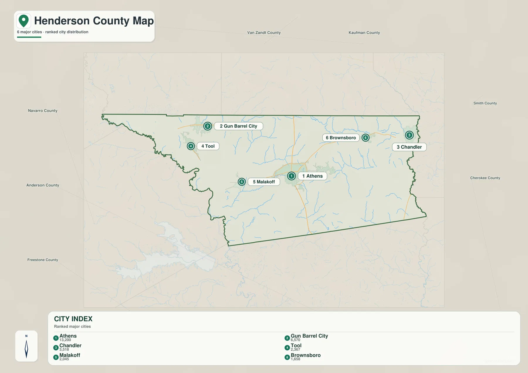
Because the city map removes much of the road detail, it makes the county’s spacing especially easy to see. Athens stands apart as the central reference, Tool and Gun Barrel City form a close western pair, and Brownsboro and Chandler are spread across the northeast. Comparing this simplified view with the general map adds the road and reservoir context back without losing the city pattern.
Cedar Creek Reservoir dominates the west while creeks and lakes divide the interior
Cedar Creek Reservoir is the largest and most obvious water feature on the supplied terrain and water map. Its branching shoreline reaches into the western side of Henderson County and creates a very different landscape from the smaller streams farther east. Caney Creek is labeled across the west-central interior, while Walnut Creek curves through the southwest.
The northeastern drainage network includes Kickapoo Creek, and Pine Creek is labeled farther south on the eastern side. Lake Athens and Underwood Lake sit closer to the center-east, while Echo Lake, Murchison Lake, Rainbo Lake, Caddo Creek Lake, and Coon Creek Lake are among the smaller named water bodies shown on the map. The overall picture is not one reservoir with empty land around it, but a county crossed by many creeks and dotted with small lakes.
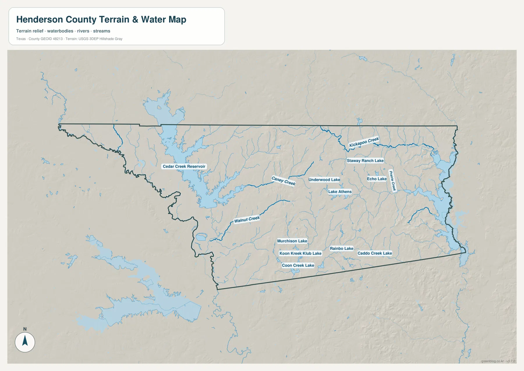
This map is intended for geographic orientation. It does not show flood zones, water depth, property ownership, or navigation status. Its best use here is to compare the position of towns and roads with the reservoir, named creeks, and lake basins, then match those valleys with the lower areas visible on the elevation map.
Elevation rises from the western reservoir lowlands into the central and eastern hills
The elevation legend gives an actual minimum near 72 meters, a maximum near 234 meters, and a mean of about 124 meters. Greens dominate much of the western side around Cedar Creek Reservoir and the southwest, indicating relatively low ground. Yellow, orange, and brown areas become more common across the central-east and northeast, where the terrain is higher and more broken.
The higher part of the county is not a single flat block. Numerous narrow valleys cut through it, matching the creek network visible on the water map. Around Caney Creek and Kickapoo Creek, lower bands work their way between higher ridges, while the broad reservoir area remains visibly lower. This contrast explains why the shaded relief looks much rougher east of the reservoir.
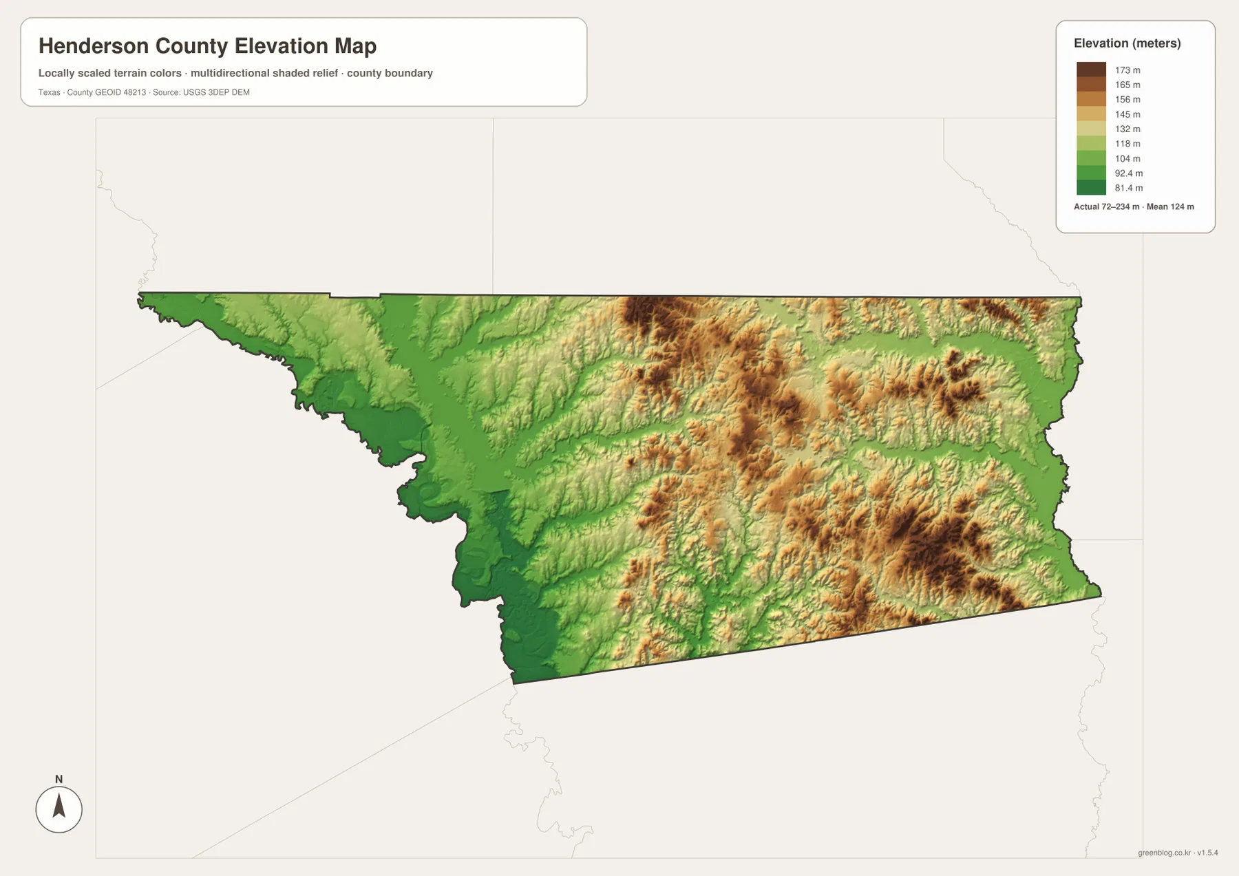
The elevation surface is suitable for comparing county-wide relief, not for survey-grade measurements at a road, building site, or property. It is most useful when paired with the water map to locate broad valleys and higher ground, or when explaining why the western reservoir landscape looks different from the more rolling terrain around the central and eastern parts of the county.
Using the road, city, water, and elevation views together
For a quick location check, start with Athens on the general map and follow the road markers outward. The ranked city map is better when the goal is to compare Athens, Gun Barrel City, Chandler, Tool, Malakoff, and Brownsboro without the extra road detail. Cedar Creek Reservoir, Lake Athens, and named creeks are easiest to find on the water map.
The elevation view becomes most useful after those locations are familiar. For example, Gun Barrel City and Tool can first be located beside Cedar Creek Reservoir, then compared with the lower green terrain around the reservoir. East of Athens, the water map shows more small drainage lines and the elevation map shows more high ground, so the two maps together explain the stronger relief in that part of the county.
The WebP images in the article are optimized for on-page viewing, while the ZIP contains the larger original JPG versions of the same map set. The files can be used separately for printing, teaching, presentations, or local reference when one map type is more useful than the others.
Frequently Asked Questions
What is the easiest place to use as a reference on a Henderson County map?
Athens is the best starting point because it is near the center of the county and several numbered roads meet or pass nearby. From Athens, you can move west toward Malakoff and Cedar Creek Reservoir or east toward Brownsboro and Chandler while keeping the county layout easy to follow.
Which map shows Cedar Creek Reservoir and Lake Athens most clearly?
The terrain and water map is the clearest choice. It emphasizes Cedar Creek Reservoir, Lake Athens, Caney Creek, Walnut Creek, Kickapoo Creek, and many smaller lakes and drainage lines that are less prominent on the general road map.
How much elevation change is shown across Henderson County?
The supplied elevation legend shows an actual range of about 72 to 234 meters with a mean near 124 meters. The western reservoir area is generally lower, while more of the central-east and northeast is shown as higher, hillier ground.
Sources and Reference Data
For official geographic reference, see the U.S. Census Bureau TIGER/Line Shapefiles for boundaries and places, USGS National Hydrography for water features, and the USGS 3D Elevation Program for elevation data. The USGS The National Map Viewer is also useful for checking national map layers.
Map File Information
You can download A3 high-resolution JPG files matching the Henderson County maps shown in this article as one ZIP archive.
- File Type: JPG
Related Maps
- Anderson County Texas map
- Navarro County Texas map
- Smith County Texas map
- Van Zandt County Texas map
- Angelina County Texas map
Green Map creates custom-edited map images using open geographic data sources such as geoBoundaries, Natural Earth, OpenStreetMap, and government open data.
These maps are edited visual materials, not raw data files, and are provided for education, documents, presentations, and graphic reference.