Hidalgo County sits at the southern edge of Texas, where a dense chain of cities occupies the lower part of the county while a much broader, lightly marked interior stretches north. On a Hidalgo County Texas Map, that north-south contrast is one of the first features to stand out. McAllen, Edinburg, Mission, Pharr, San Juan, Weslaco, and Mercedes form the most visually concentrated part of the map, with the Rio Grande tracing the county’s irregular southern boundary. This page brings the county, city, water, and elevation views together so you can compare those patterns without treating the county as one uniform landscape.
You can download the original A3 high-resolution JPG map files from the map file box later on this page. The on-page WebP images are intended for quick viewing, while the ZIP contains the four JPG versions shown here: county, city, water, and elevation maps. A useful way to begin is to locate the McAllen–Edinburg area and the Rio Grande first, then compare that compact southern urban belt with the much more open northern half.
Table of Contents
A County Shaped by a Dense South and an Open North
The general county map makes the contrast easy to see. The southern boundary bends with the Rio Grande, while the north and east include long straighter county lines. Built-up areas and road markings cluster across the lower portion of the county rather than spreading evenly from border to border. Edinburg lies north of McAllen, and the urban fabric continues west toward Mission and Palmview and east toward Pharr, San Juan, Alamo, Weslaco, and Mercedes.
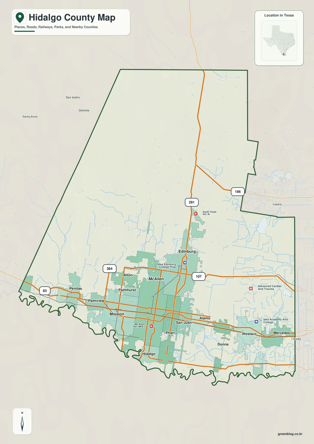
Several route numbers provide quick reference points. Route 83 runs across the southern city belt from the Mission and Palmview side through the McAllen area toward Weslaco and Mercedes. Route 281 turns north through Edinburg, while 107, 186, and 364 help locate other parts of the road network. The map therefore works well for a first orientation: it shows where the city concentration ends, where the large northern interior begins, and how the principal roads connect those very different parts of the county.
McAllen, Edinburg, and the Southern Chain of Cities
The city map ranks six major places and makes their spacing especially clear. McAllen is plotted in the south-central part of the county, Edinburg immediately to the north, Mission to the west, and Pharr and San Juan close to McAllen on the east and southeast. Weslaco stands farther east. That arrangement matters because the largest places are not isolated dots; they form a broad, closely spaced urban band across the southern portion of Hidalgo County.
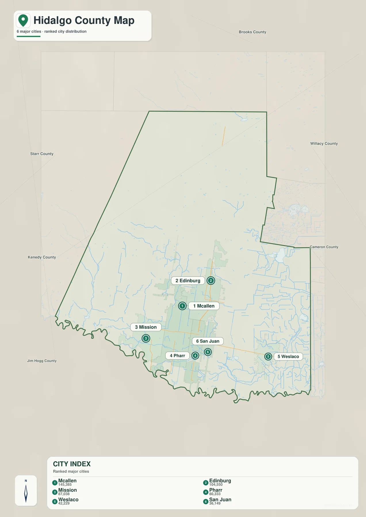
The values printed in the city index are McAllen 145,385, Edinburg 104,550, Mission 87,038, Pharr 80,337, Weslaco 42,229, and San Juan 36,149. Those numbers are best treated as the values shown on this map rather than as a substitute for a current population table. For map reading, their main value is comparative: McAllen and Edinburg anchor the largest pair, Mission extends the cluster westward, and Pharr, San Juan, and Weslaco continue it to the east.
The northern half tells a different story. No similarly ranked city appears across the broad interior north of Edinburg. When the city map is viewed beside the county map, the uneven settlement pattern becomes one of Hidalgo County’s defining visual features. The county contains a large area, but its most prominent cities, denser roads, and many named facilities are concentrated far closer to the Rio Grande than to the northern boundary.
Roads That Tie the Valley Cities Together
The existing county material identifies I-2/US 83 as the main east-west corridor through the southern urban belt and I-69C/US 281 as the north-south route through Edinburg. On the map itself, the 83 and 281 route markers are easy to use as anchors. Once they are located, routes 107, 186, and 364 add detail without overwhelming the view. This sequence is useful because it separates the long cross-county connection from the roads that serve individual cities and outer areas.
West of McAllen, Mission, Palmview, and Peñitas sit along the lower road network. East of McAllen, the sequence through Pharr, San Juan, Alamo, Weslaco, and Mercedes gives the map a continuous urban character. Edinburg is offset to the north, where the route toward the county interior becomes more obvious. Looking at these roads together explains the county’s geography more clearly than focusing on any single highway shield.
Rio Grande, Canals, Lakes, and Reservoirs
The water map adds a very different layer of detail. The Rio Grande forms the winding southern edge, but the named water features extend well beyond the river itself. La Joya Creek and La Joya Lake appear in the west. Sapo Lake, Seminary Lake, and Lake Jones are scattered across the central part of the county, while Edinburg Main Canal and Mission Branch Pilot Canal show named channels within the southern half.
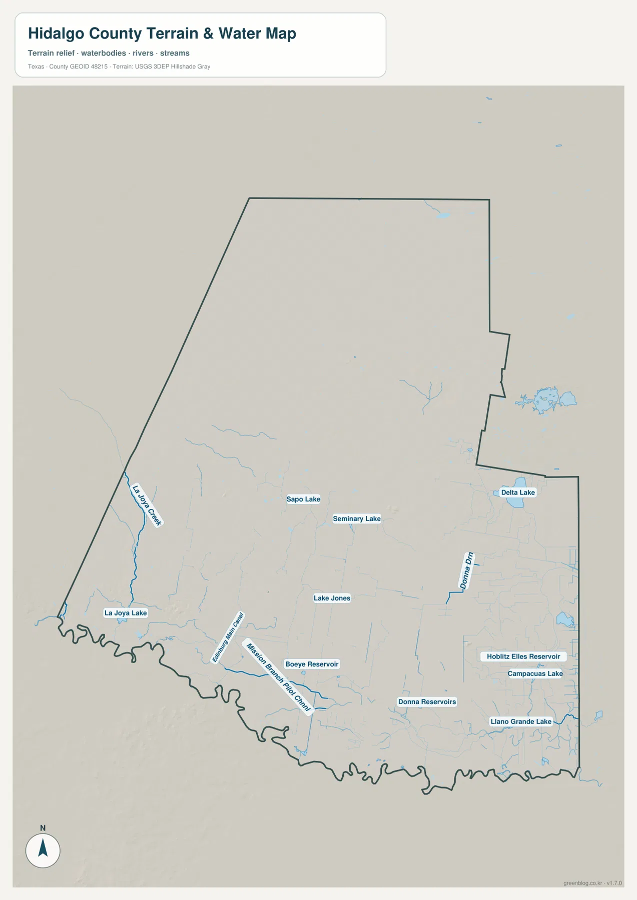
Farther east, Delta Lake sits near the county’s eastern side. Donna Reservoirs and Llano Grande Lake appear in the southeast, with Hoblit Elles Reservoir and Campacuas Lake also labeled nearby. Boeye Reservoir is shown closer to the south-central area. These labels make the water map useful for identifying specific features that disappear into the background on the general road map, especially around the heavily settled southern part of the county.
This map should be read as a location guide to the water features shown, not as a flood-risk or legal water-rights map. Its strength is the ability to compare the Rio Grande border, named canals, reservoirs, and small lakes on one page. Switching back to the city map then makes it easier to see which water features are close to the McAllen–Mission area, the Edinburg side of the county, and the Weslaco–Mercedes corridor.
Higher Ground in the West, Lower Terrain Toward the East
The elevation map shows a measurable change across a county that may look generally flat on a road map. The legend reports an actual elevation range of about 7 to 114 meters, with a mean of about 38 meters. Brown and tan colors dominate much of the west and northwest, indicating the higher part of the county, while greens become more common toward the central, eastern, and southern areas.
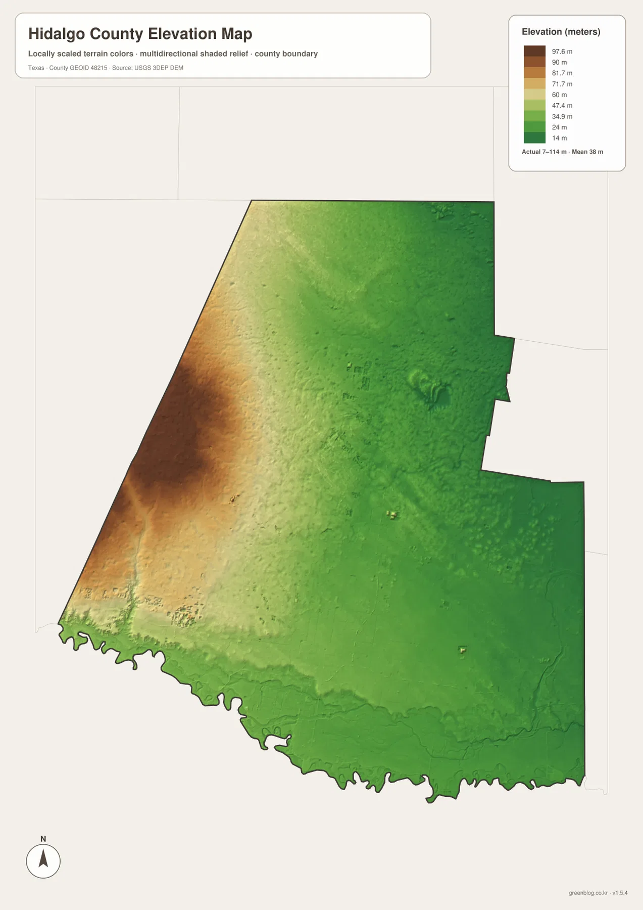
The low terrain along much of the Rio Grande is visible as a narrow green zone following the southern edge. The strongest higher colors are farther west and northwest, while the east remains comparatively low. Viewing this map beside the water map gives the color changes useful context: the elevation layer shows relative height, and the water layer shows the named channels and reservoirs occupying the same county. It is not a parcel survey, so exact site elevations should be obtained from dedicated elevation data when precision is required.
Which Hidalgo County Map Fits the Task?
Use the county map when the priority is boundaries, cities, and roads. Choose the city map when you want a quick comparison of McAllen, Edinburg, Mission, Pharr, Weslaco, and San Juan. The water map is the better choice for La Joya Creek, Delta Lake, reservoirs, canals, and other named water features, while the elevation map is designed for comparing the higher western interior with the lower east and south. Moving between the four views is more informative than trying to force every question onto one layer.
For printing, classroom work, presentations, or a larger local reference, the ZIP below contains the A3 high-resolution JPG versions that correspond to the four map views on this page. They can be saved separately after the archive is opened, giving you a cleaner file for print use than the smaller WebP previews embedded in the article.
Frequently Asked Questions
Where are Hidalgo County’s largest cities concentrated?
The ranked cities on the supplied map are concentrated in the southern part of the county. McAllen and Edinburg form the largest pair shown, with Mission to the west and Pharr, San Juan, and Weslaco extending the urban pattern eastward.
What named water features can I find besides the Rio Grande?
The water map labels La Joya Creek, La Joya Lake, Sapo Lake, Seminary Lake, Lake Jones, Delta Lake, Donna Reservoirs, Llano Grande Lake, several other reservoirs, and named canals including Edinburg Main Canal and Mission Branch Pilot Canal.
What does the Hidalgo County elevation map show?
It shows an actual range of about 7 to 114 meters and a mean of about 38 meters. The western and northwestern parts are generally higher, while lower colors spread across much of the east and along the Rio Grande side of the county.
Map File Information
The ZIP contains the A3 high-resolution JPG versions of the Hidalgo County county, city, water, and elevation maps.
- File Type: 4 JPG files in one ZIP
Related Maps
- Starr County
- Willacy County Texas map
- Webb County Texas map
- Zapata County Texas map
- San Patricio County Texas map
Sources and References
Boundary and road reference data can be checked through the U.S. Census Bureau TIGER/Line Shapefiles. Water features can be cross-referenced with USGS National Hydrography, while elevation information is available from the USGS 3D Elevation Program. For an interactive national reference, see USGS The National Map Viewer.
Green Map creates custom-edited map images using open geographic data sources such as geoBoundaries, Natural Earth, OpenStreetMap, and government open data.
These maps are edited visual materials, not raw data files, and are provided for education, documents, presentations, and graphic reference.