Download the high-resolution A3 JPG Zapata County map set as one ZIP file directly from this page. The package includes the supplied county overview, terrain-and-water map, and elevation map for printing, classroom work, presentations, document layouts, or offline reference. In the article, Zapata serves as the main reference point, while San Ygnacio, Ramireño, Las Palmas, Falcon Mesa, Siesta Shores, Lopeño, New Falcon, and other labeled places show how communities are arranged along the western border. The maps also make it easy to compare U.S. 83, State Highway 16, Falcon International Reservoir, smaller creeks and lakes, and the county’s rise toward the eastern interior.
Zapata County has a shape and settlement pattern that make sense only when the border water is kept in view. The Rio Grande and Falcon International Reservoir define much of the county’s western side, and many of the labeled communities sit near that edge rather than in the broad eastern interior. Zapata, the county seat, stands out because U.S. 83 runs through it and State Highway 16 heads inland from the same area. That combination of shoreline, road corridor, and rising terrain gives the county a strong west-to-east contrast that appears in all three supplied maps.
Table of Contents
Communities concentrated along the Falcon Reservoir side
The general county map makes the settlement pattern immediately visible. Zapata sits near the western side of the county, and a series of smaller places continues north and south along the same broad corridor. Las Palmas, Ramireño, and San Ygnacio are to the north. Falcon Mesa and Siesta Shores are just south of Zapata near the reservoir, followed farther south by Morales-Sanchez, Lopeño, New Falcon, and Los Lobos. The eastern half of the county looks much more open because fewer communities are labeled there and the mapped roads are spread across a larger area.
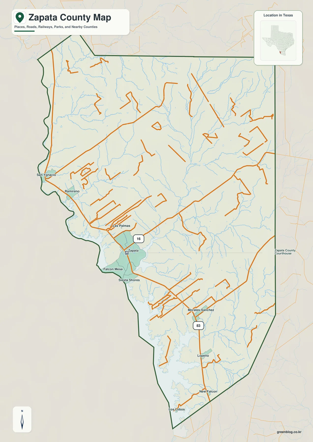
U.S. 83 is the easiest feature to use for orientation. It follows the western side of the county and links many of the places shown on the map. From Zapata, the route runs north toward Las Palmas, Ramireño, and San Ygnacio and south toward Falcon Mesa, Siesta Shores, Lopeño, and New Falcon. State Highway 16 leaves the Zapata area and extends east across the interior. Together, these roads show two different movement patterns: a north-south corridor close to the border and an inland connection that cuts across the wide eastern part of the county.
The size of the symbols also helps the reader understand which place functions as the main center. Zapata is shown as a larger built-up area, while the communities around it are smaller and more scattered. This is useful for a county-scale map because it keeps the focus on regional position rather than street-by-street navigation. A reader can quickly tell which communities are north of the county seat, which are farther south, and which road provides the main link between them without having to work through a dense road atlas.
Using Zapata, U.S. 83, and Highway 16 as reference points
For someone unfamiliar with the county, starting at Zapata and tracing U.S. 83 is more helpful than reading every place name at once. The road gives the map a clear north-south line near Falcon Reservoir. San Ygnacio provides a useful northern reference, and New Falcon marks the lower part of the mapped corridor. Smaller communities between them fill in the shoreline sequence. The exact travel distance between places depends on the road and destination, but the county map makes the basic direction of travel easy to understand.
Highway 16 changes that picture by drawing attention inland. Most labeled settlements are closer to the west, yet the county extends a long distance to the east. The highway leaves Zapata and runs toward the eastern boundary, making the full width of the county much easier to grasp. This matters in a presentation or written explanation because a map focused only on the reservoir communities could give the impression that Zapata County is a narrow strip. In reality, the county has a large interior crossed by smaller roads, creeks, and rolling terrain.
The western boundary is also far from straight. Falcon Reservoir occupies the impounded Rio Grande along the Texas-Mexico border, and its coves create a deeply indented shoreline through the middle and southern parts of the county. Several settlement names appear close to that irregular edge. Comparing the road map with the water map explains why some locations seem close together on a simple outline but are separated by long shoreline curves or branches of the reservoir.
Falcon Reservoir, creeks, and small inland lakes
The terrain-and-water map shifts attention away from highways and toward drainage. The broad water body along the west and southwest is part of Falcon International Reservoir, an impoundment on the Rio Grande shared by Texas and Mexico. Texas Parks and Wildlife identifies the reservoir in Zapata and Starr counties. Within the Zapata County outline, long coves and narrow arms reach inland from the main reservoir, especially through the central and southern shoreline. These shapes are much easier to see on the water map than on the general county map.
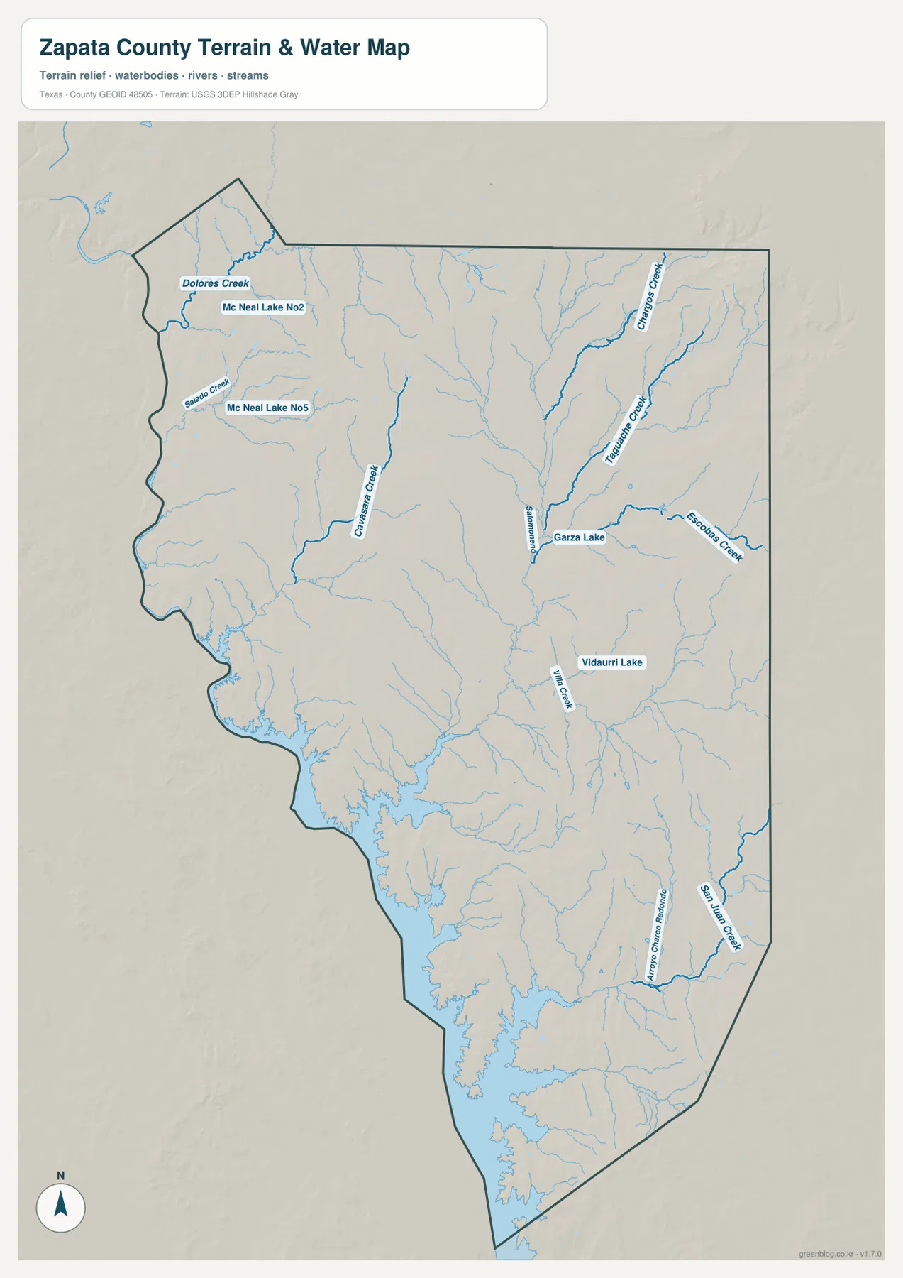
The interior contains many smaller drainage lines. In the northwestern part of the map, Dolores Creek and Salado Creek are labeled near Mc Neal Lake No 2 and Mc Neal Lake No 5. Garza Lake appears farther east, and Vidaurri Lake is labeled in the central interior. Willow Creek, Escobas Creek, and San Juan Creek are among the named channels visible in other parts of the county. Dozens of thinner blue lines branch between these labels, showing that water reaches the reservoir through many small creeks rather than through one dominant interior river.
This is especially useful when explaining the difference between the western shoreline and the inland landscape. The reservoir is the largest and most familiar water feature, but the map shows a much broader drainage network behind it. Near Zapata and the southern communities, the reservoir’s coves enter the land in long narrow shapes. Farther east, creeks occupy shallow valleys that lead toward lower ground. The map is intended for county-level geographic reference, not flood prediction, boating navigation, or property decisions, so those uses should rely on current specialized data from the responsible agencies.
Elevation rises away from the western lowlands
The elevation map provides a different explanation for the same landscape. Its legend gives an actual mapped range of about 79 to 264 meters and a mean elevation of roughly 132 meters. Green tones identify lower terrain, while yellow, tan, and brown represent progressively higher ground. The broad western side near Falcon Reservoir is generally lower, and higher terrain becomes more common toward the east and northeast. The northeast corner contains some of the darkest brown areas on the map, making the county’s relief easy to recognize even without contour lines.
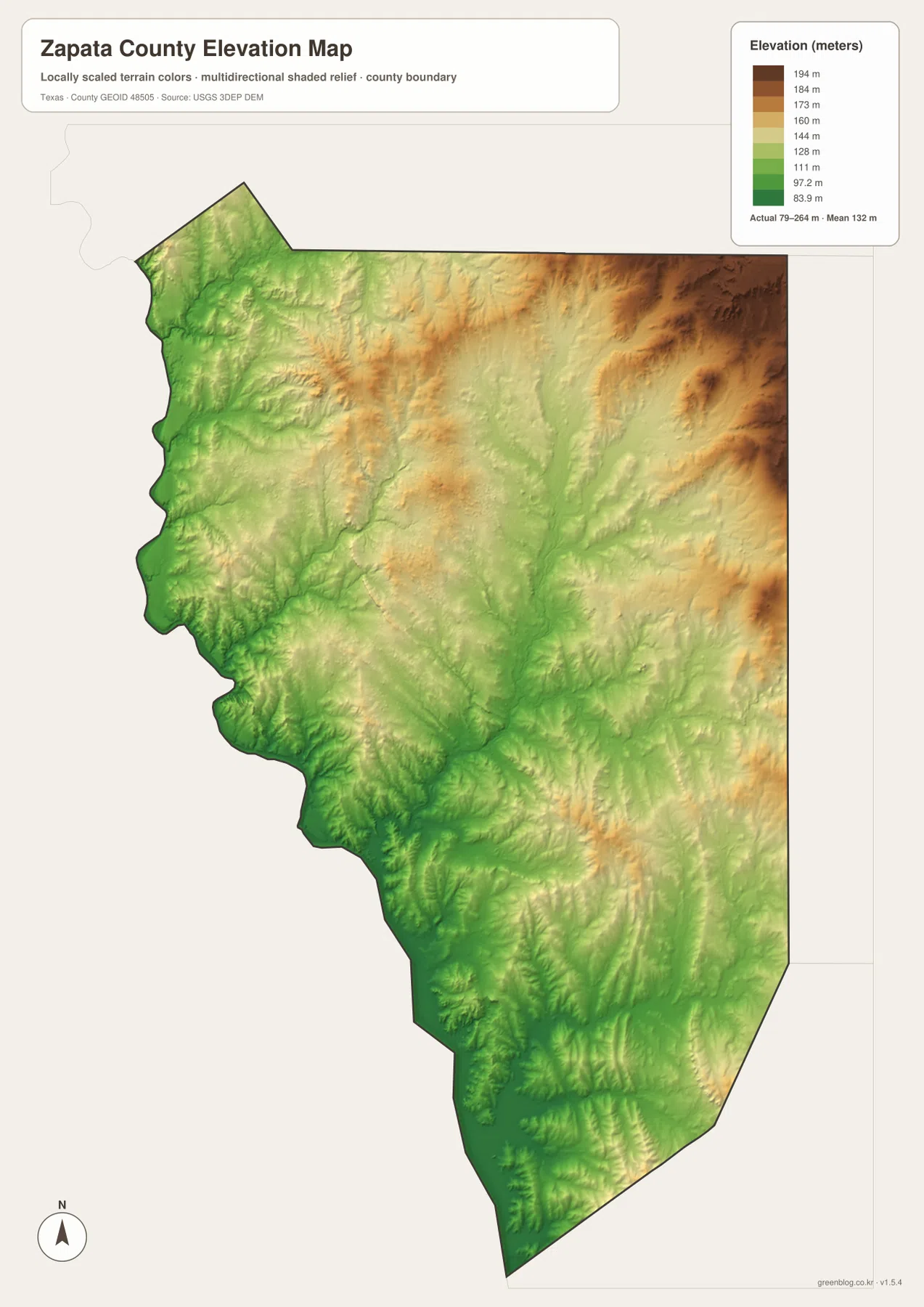
When the elevation and water maps are compared, the direction of many drainage lines becomes easier to understand. Creeks descend from higher interior ground toward the lower western side, where they eventually join the reservoir system. The color changes also reveal repeated ridges and shallow valleys instead of a single smooth slope. This makes the elevation map useful for regional explanation: it shows why the interior appears more dissected and why so many small channels run generally toward the Rio Grande side of the county.
The numbers should be treated as county-scale reference values rather than survey measurements for an individual parcel. Local hills and depressions can be smaller than the map can show, and a single color band covers a range of elevations. For classroom work, regional geography, travel context, or a report that needs a simple terrain illustration, the map provides enough detail to distinguish lowlands from higher uplands. Engineering, construction, or property-level decisions require more precise source data such as detailed USGS elevation products.
Choosing the right Zapata County map for the task
Start with the general county map when the question is about places and travel direction. It shows Zapata, San Ygnacio, Ramireño, Lopeño, New Falcon, and the other labeled communities together with U.S. 83 and Highway 16. That makes it the best single image for a quick county overview. If the topic is Falcon Reservoir, creeks, or small lakes, the terrain-and-water map removes much of the road emphasis and makes the drainage network easier to follow.
The elevation map is more useful when the subject is terrain. Its colors show the low reservoir side and the higher eastern interior without requiring the reader to interpret a dense set of contour lines. Pairing it with the water map is particularly effective because the viewer can see how creeks occupy lower routes through the uplands. For a school lesson or presentation, the three views can be used in sequence: first locate the communities and highways, then show the water system, and finally explain how the land rises away from the border.
The web images are convenient for reading the article, but the downloadable files are intended for higher-resolution use. The ZIP contains A3 JPG versions of the county map, terrain-and-water map, and elevation map. They are more suitable for printing, placing into documents, enlarging on a screen, or editing in an image-layout program than copying the smaller page previews.
Frequently Asked Questions
Where is Zapata on the county map?
Zapata is near the western side of the county beside Falcon International Reservoir. U.S. 83 runs through the community, and State Highway 16 heads east from the same area. San Ygnacio and Ramireño are north of Zapata, while Falcon Mesa, Siesta Shores, Lopeño, and New Falcon lie to the south along the broader U.S. 83 corridor. That makes Zapata the most useful starting point for understanding the county map.
How does Falcon International Reservoir shape Zapata County?
The reservoir follows much of the county’s western and southwestern side as part of the Rio Grande border system. Several mapped communities are close to its shoreline, and long coves extend into the county in the central and southern sections. Because of that, the reservoir affects both the visible shape of the boundary and the way the western communities are arranged on the map.
What elevation range is shown for Zapata County?
The supplied elevation map shows an actual range of about 79 to 264 meters with a mean of roughly 132 meters. Lower green terrain is common near the reservoir side, while higher yellow, tan, and brown terrain becomes more prominent toward the east and northeast. The map is designed for county-level comparison and should not be treated as a parcel survey.
Sources and reference data
The article is based first on the supplied Zapata County map assets and the features visible in those images. County-seat and regional background, Falcon Reservoir context, and the broader data frameworks for boundaries, hydrography, and elevation can be checked through the following authoritative resources.
- Zapata County, Texas official website – county government information and the county seat in Zapata
- Handbook of Texas: Zapata County – county history and regional background
- Texas Parks & Wildlife: Falcon International Reservoir – official reservoir location and lake information
- U.S. Census Bureau TIGER/Line Shapefiles – official geographic files for boundaries, roads, and related features
- USGS National Hydrography – federal hydrography information for rivers, streams, and water bodies
- USGS 3D Elevation Program – official U.S. elevation and terrain data
Map File Information
The ZIP contains high-resolution A3 JPG versions of the Zapata County general map, terrain-and-water map, and elevation map. They are suitable for printing, presentations, document layouts, offline reference, and image editing.
- File Type: ZIP containing three JPG files
Related Maps
Green Map creates custom-edited map images using open geographic data sources such as geoBoundaries, Natural Earth, OpenStreetMap, and government open data.
These maps are edited visual materials, not raw data files, and are provided for education, documents, presentations, and graphic reference.