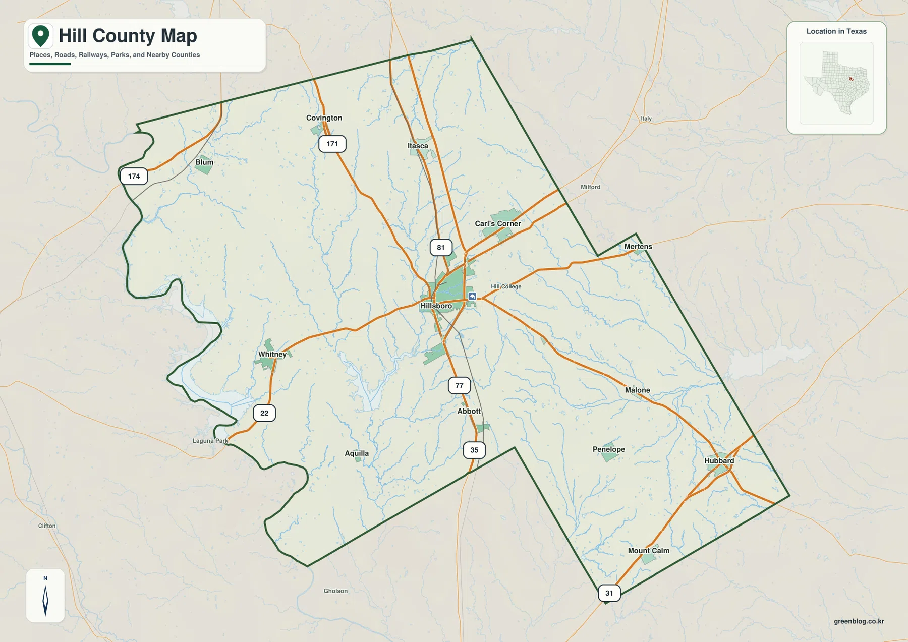
Hill County in north-central Texas is easiest to understand by using Hillsboro as the central reference and the Brazos River–Lake Whitney area as the western reference. Major roads converge around Hillsboro, while the county’s western edge bends around river and reservoir terrain rather than following only straight boundary lines. This page explains the county through roads, towns, waterways, and elevation, and the same maps are available as high-resolution JPG files in a downloadable ZIP archive.
The county does not read as one compact cluster around a single town. Itasca and Covington sit to the north of Hillsboro, Whitney and Aquilla pull the map westward, Abbott lies to the south, and Hubbard, Penelope, and Mount Calm extend the county toward the east and southeast. That spread matters because the western side is shaped strongly by the Brazos River and Lake Whitney, while the interior and eastern side contain a denser network of smaller creeks. Reading the maps together makes those differences much clearer than a town list alone.
Table of Contents
Hillsboro provides the clearest starting point for roads and boundaries
On the general county map, Hillsboro appears close to the middle of Hill County and sits near several important route labels. Interstate 35 and the marked 77 and 81 corridors make the city a practical reference for comparing the rest of the county. Itasca and Covington are north of Hillsboro, Abbott is south, and Whitney lies to the west along the route toward the Lake Whitney side. Blum appears in the northwest and Aquilla in the southwest, adding useful reference points before the boundary reaches the Brazos River area.
East of Hillsboro, the map shows Mertens and Malone before the county extends toward Hubbard, Penelope, and Mount Calm. These communities are far enough from the county seat to make the eastern and southeastern reaches feel distinct from the central road hub. The neighboring-county labels also help with orientation: Bosque, McLennan, and Somervell are shown to the west and southwest, while Ellis, Johnson, Navarro, and Limestone frame the northern and eastern sides.
The outline itself is worth noticing. Long straight segments occur along parts of the north and east, but the western edge is much more irregular where the boundary approaches the Brazos River and Lake Whitney area. A noticeable inward notch also breaks up the southern side. These changes in shape are useful when matching a place name to the correct county and when comparing Hill County with neighboring Texas counties that have simpler outlines.
Six highlighted towns show how far Hill County spreads in different directions
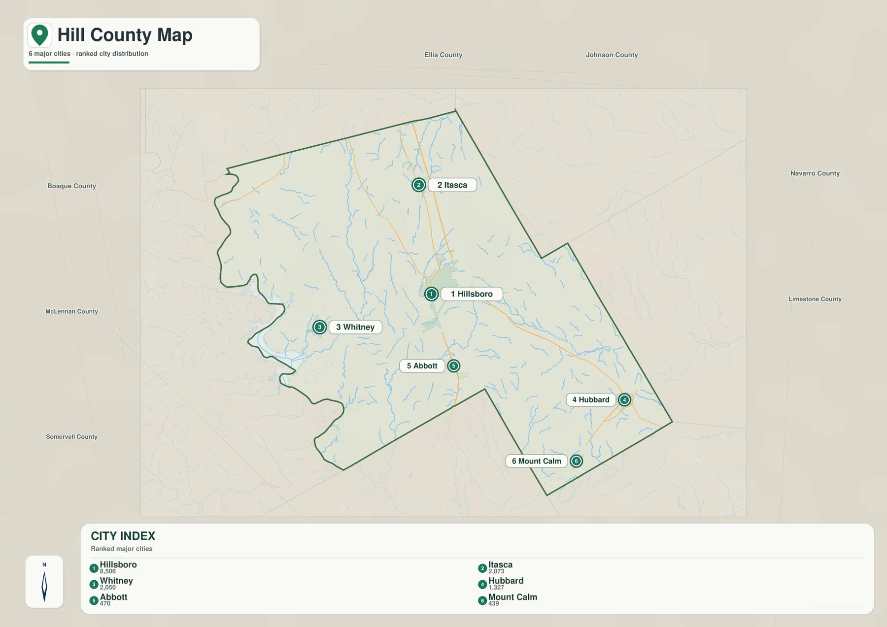
The simplified city map highlights Hillsboro, Itasca, Whitney, Hubbard, Abbott, and Mount Calm. Hillsboro gives the viewer a central reference, but the other five communities are deliberately spread across the county: Itasca is north, Whitney west, Abbott south, Hubbard east, and Mount Calm southeast. Seeing all six on one uncluttered map makes the county’s basic settlement pattern easier to remember before moving to the more detailed road map.
Whitney and Hubbard are especially useful as opposite-side reference points. Whitney places you near the western water landscape, where the Brazos River and Lake Whitney influence the boundary and local geography. Hubbard, by contrast, helps locate the eastern side and the small-creek systems that appear there. Itasca sits close to the northern part of the county, while Abbott gives a simple landmark south of Hillsboro along the central north–south corridor.
This city map is not intended to replace a street map or a turn-by-turn navigation service. Its value is that it strips away most detail and lets you compare the major communities first. Once you know that Whitney is west of Hillsboro or Mount Calm is southeast, the general county map becomes easier to use because road numbers, neighboring towns, and boundary segments have a clearer geographic context.
The Brazos River shapes the west while smaller creeks fill the interior
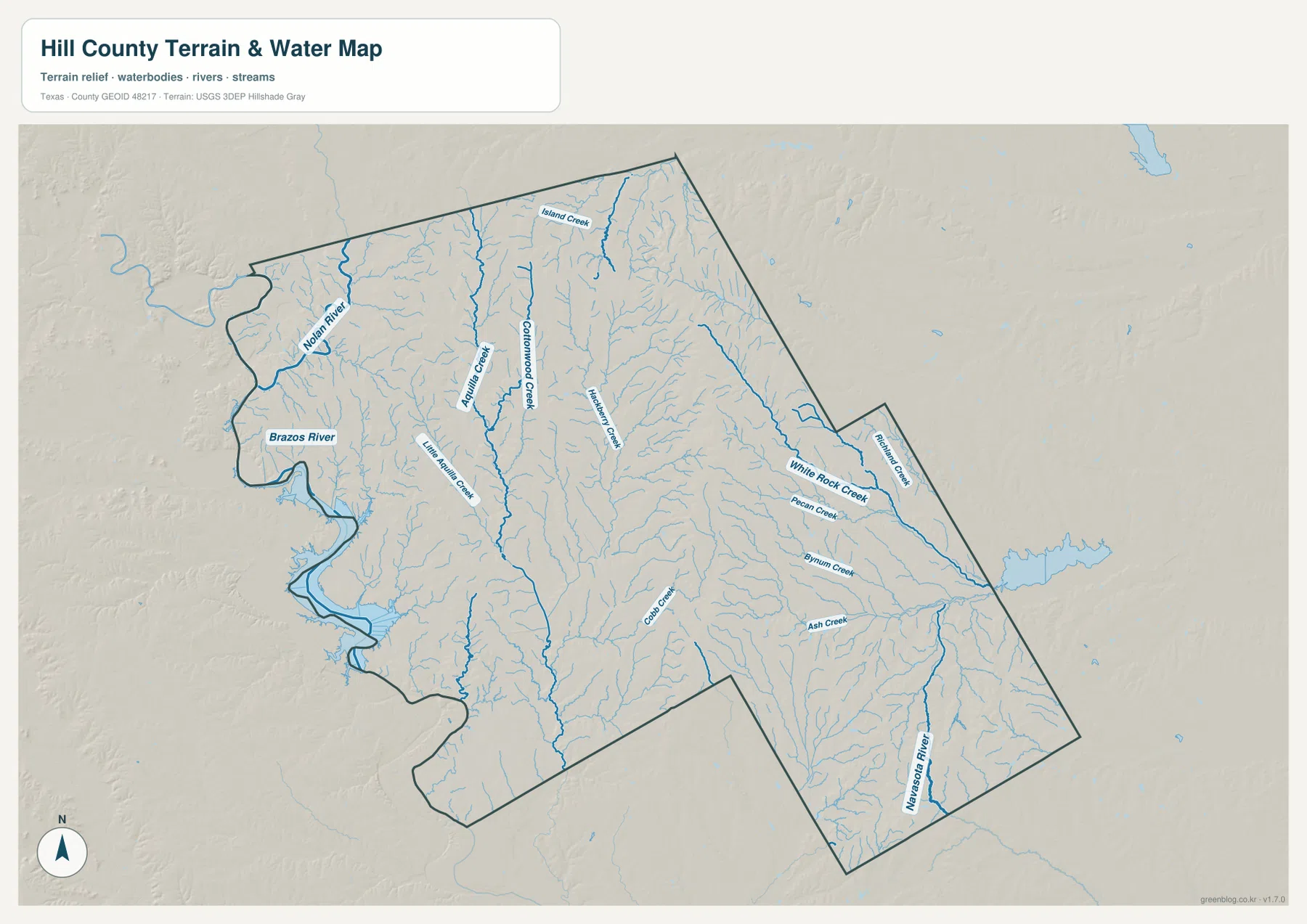
The strongest water feature on the terrain-and-water map is the Brazos River along the western side of the county. Its position helps explain why the western boundary looks curved and irregular on the general map. Whitney lies close to this water-focused part of the county, making it a useful town reference for readers looking for the Lake Whitney area or trying to understand why western Hill County has a different outline from the straighter northern and eastern edges.
Inside the county, Nolan River and Aquilla Creek form two of the more prominent named waterways. Cottonwood Creek and Hackberry Creek appear through the central area, while White Rock Creek, Pecan Creek, Bynum Creek, Ash Creek, and Richland Creek are labeled farther east. Together they show that Hill County is crossed by many small drainage lines rather than being defined only by the Brazos River.
Comparing the water map with the town map also makes the east–west contrast easier to see. Whitney is associated with the large river-and-reservoir landscape on the west, whereas Hillsboro and the eastern communities sit among smaller creeks. The map is designed for regional orientation, not for flood-zone decisions, water-depth estimates, navigation, legal riparian boundaries, or current river conditions. Those purposes require specialized and up-to-date sources.
Elevation colors reveal low river ground and higher northern ridges
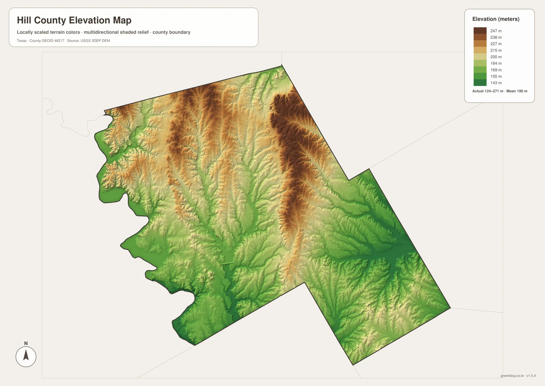
The elevation map shows an actual county-wide range of about 124 to 271 meters, with a mean near 190 meters. Green shades represent lower ground and brown shades represent higher terrain. Hill County is not a high-mountain landscape, but the color pattern makes it clear that the surface is not uniformly flat. Valleys cut through broader rolling areas, and higher ridges appear in several northern and central sections.
Lower terrain is especially noticeable along the western Brazos River side and across parts of the southwest. Higher brown-toned bands extend through the north and north-central area, with another long elevated feature visible in the east-central part of the county. Between those higher areas, creek valleys form lower corridors. When the elevation and water maps are viewed side by side, many of the blue drainage lines follow these lower parts of the terrain.
That pattern is useful for understanding the county at a regional scale, whether you are comparing town settings, planning a general drive, or studying the relationship between waterways and terrain. It should not be treated as survey-grade or engineering-grade elevation. A property boundary, construction site, drainage design, or exact slope calculation requires authoritative source data and, when appropriate, a professional survey.
Lake Whitney makes the western side feel different from the east
Western Hill County is easiest to recognize by combining Whitney, the Brazos River, and the irregular boundary near Lake Whitney. On the general map, follow the road toward Whitney and then look at the county edge; on the water map, the same area becomes a river-and-reservoir landscape. This two-map comparison is more useful than looking for a lake name alone because it places the water feature in relation to towns, roads, and the county line.
The eastern and southeastern parts of the county have a different visual character. Hubbard and Mount Calm act as town references, and the water map shows numerous smaller creeks rather than one dominant reservoir edge. Penelope and Malone add context between Hillsboro and the far eastern boundary. Moving from the Whitney side to the Hubbard side therefore changes both the settlement pattern and the way water features appear on the map.
If you are planning a visit to Lake Whitney, use these maps for county-level orientation rather than for current facility details. Park entrances, boat ramps, closures, hours, and operating conditions can change over time. Texas Parks & Wildlife Department provides current visitor information for Lake Whitney State Park, while the maps on this page are intended to explain the more stable geographic relationship among the lake area, Whitney, Hillsboro, and the rest of the county.
Choose the map by the question you need to answer
For a first look at Hill County, the general map is the most complete starting point because it combines place names, major route labels, neighboring counties, and the county boundary. The city map is faster when you only need the relative positions of the six highlighted communities. For the Brazos River, Nolan River, Aquilla Creek, or the eastern creek network, use the terrain-and-water map; for valleys, ridges, and relative height, the elevation map is the better choice.
| Map | Best for | Not intended for |
|---|---|---|
| General county map | Hillsboro, Whitney, major roads, boundaries, and nearby counties | Street-level navigation or parcel surveying |
| City map | Comparing Hillsboro, Itasca, Whitney, Hubbard, Abbott, and Mount Calm | Detailed local street networks |
| Terrain & water map | Brazos River, Nolan River, Aquilla Creek, and eastern creek systems | Flood zones, water depths, navigation, or legal boundaries |
| Elevation map | Approximate 124–271 m relief, valleys, and higher ridges | Survey-grade or engineering-grade elevation |
When you need larger copies for printing, teaching, offline reference, or side-by-side comparison, use the ZIP package below. It contains the high-resolution JPG versions corresponding to the four maps in this article, so you can compare roads with waterways or elevation without relying on the smaller page images.
Frequently Asked Questions
Which map should I use first to find the Lake Whitney side of Hill County?
Start with the general county map to locate Whitney, the western boundary, and the main road connection from Hillsboro. Then switch to the terrain-and-water map to follow the Brazos River and the larger water features. For current park access, ramps, closures, or operating conditions, check the latest information from the responsible agency.
Which communities are highlighted on the Hill County city map?
The city map highlights Hillsboro, Itasca, Whitney, Hubbard, Abbott, and Mount Calm. Hillsboro provides the central reference, while the other five communities show how the county extends north, west, east, south, and southeast. The simplified layout is useful before you move to the more detailed road and boundary map.
Can the 124–271 m elevation map be used for a property survey or construction plan?
No. The elevation image is a generalized county-wide surface intended to compare relative highs, lows, ridges, and valleys. Its displayed range is useful for regional orientation, but a specific site requires authoritative elevation data and, when necessary, a professional survey.
Map File Information
Download the Hill County general, city, water, and elevation maps as high-resolution JPG files in one ZIP archive.
- Included Files: 4 maps
- File Type: JPG
Related Maps
- Navarro County Texas map
- Somervell County
- Parker County Texas map
- Tarrant County Texas map
- Robertson County Texas map
Sources and references
- Hill County, Texas official website — county government and local reference information
- Texas State Historical Association: Hill County — county geography and historical background
- Texas Parks & Wildlife Department: Lake Whitney State Park — current park and visitor information
- USGS National Hydrography — U.S. hydrography reference
- USGS 3D Elevation Program — elevation program and data guidance
Green Map creates custom-edited map images using open geographic data sources such as geoBoundaries, Natural Earth, OpenStreetMap, and government open data.
These maps are edited visual materials, not raw data files, and are provided for education, documents, presentations, and graphic reference.