Hockley County sits on the South Plains of West Texas, immediately west of Lubbock County, with Levelland serving as the county seat and the clearest reference point on the map. You can download the Hockley County maps on this page as four high-resolution A3 JPG files packed into one ZIP archive for printing, classroom work, or local reference. The set includes a boundary-and-road map, a city distribution map, a terrain and water map, and an elevation map, while the on-page versions let you review the same county features before downloading the files.
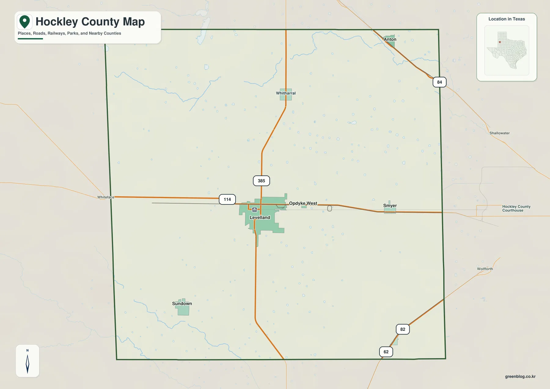
The county is easy to orient once Levelland is located near the middle. U.S. 385 runs north and south through the city, while State Highway 114 crosses the county from west to east. Anton lies near the northeastern side, Sundown is southwest of Levelland, and Ropesville is in the southeast. Smyer and Opdyke West appear east of Levelland along the SH 114 direction. The broad spacing among these communities is a strong visual feature of Hockley County and fits the open High Plains setting shown across the maps.
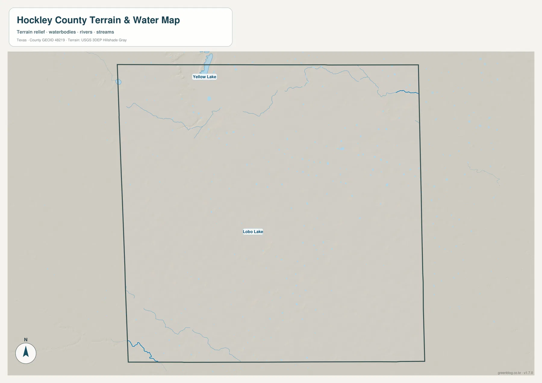
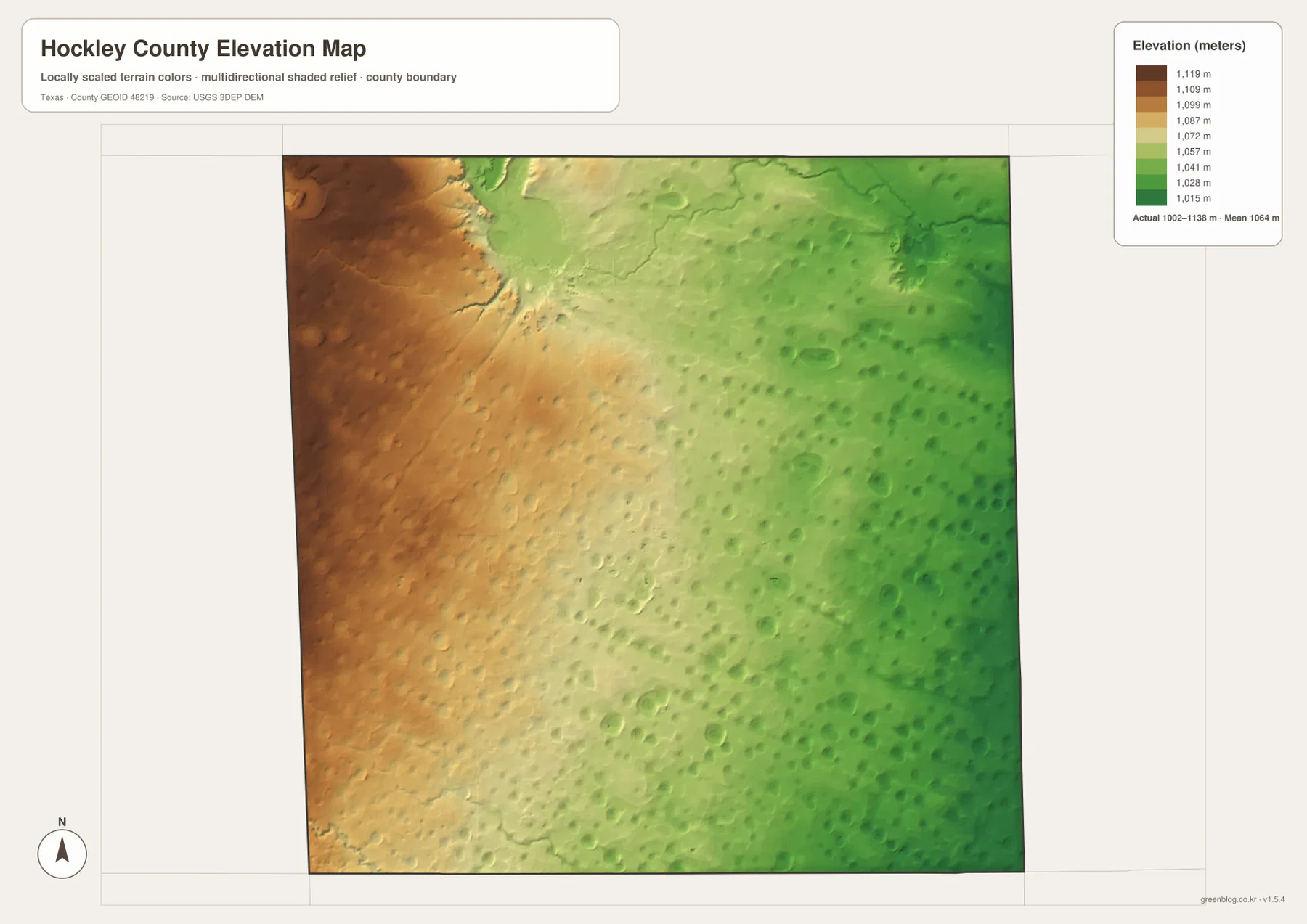
The physical maps add details that are easy to miss on a road map. Yellow Lake is labeled near the northern edge and Lobo Lake appears closer to the center, while smaller channels and water features are scattered rather than organized around one large river. The elevation surface ranges from about 1,002 to 1,138 meters, with a mapped mean near 1,064 meters. Higher colors dominate the west and lower colors become more common toward the east, revealing a gradual change across terrain that otherwise looks broadly level.
Table of Contents
Levelland gives the county its clearest road reference
On the general county map, Levelland sits slightly west of the county’s center and stands out where U.S. 385 meets SH 114. That junction is the most useful starting point for reading the rest of the county. Following U.S. 385 north leads through the Whitharral area toward Anton, while SH 114 continues west toward Whiteface and east through the Smyer direction toward Lubbock County. Roads also extend south from Levelland, connecting the central part of the county with communities and routes beyond the southern boundary.
The county outline is close to rectangular, which makes neighboring areas relatively easy to compare. Lamb County is shown to the north, Lubbock County to the east, and Cochran County to the west. Terry County and Yoakum County are visible around the southern and southwestern sides of the surrounding map. Because the preview includes roads and places outside the boundary, it is useful not only for locating Hockley County but also for seeing how travel continues toward Lubbock and the neighboring South Plains counties.
Six mapped communities show how settlement is spread across the county
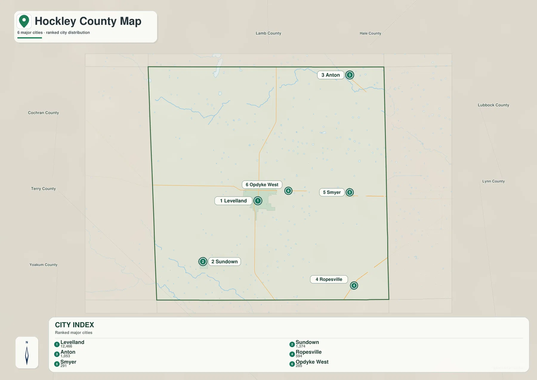
The city map ranks six communities and makes their separation much clearer than the more detailed base map. Levelland is shown with 12,466 residents, well ahead of the other places in the index. Sundown is listed at 1,374 and Anton at 1,053. Ropesville is shown at 594, while Smyer and Opdyke West are listed at 291 and 285. These figures are presented on the supplied map and are most useful here as a way to understand the relative size of the mapped communities rather than as a substitute for a current demographic table.
The positions matter as much as the ranking. Anton is near the northeastern edge, Sundown sits in the southwest, and Ropesville is far to the southeast. Smyer and Opdyke West are both east of Levelland along the east-west road corridor. This spread means that a map centered only on Levelland would hide much of the county’s settlement pattern. Looking at the six places together gives a better sense of how communities are separated by broad areas of open land.
Yellow Lake and Lobo Lake stand out on a sparse water map
Hockley County does not appear on the supplied water map as a place organized around one large river. Instead, smaller channels, lake features, and low areas are scattered across the county. Yellow Lake is labeled close to the northern boundary, while Lobo Lake appears nearer the central portion of the map. Thin blue channels are most noticeable across the north and northwest, with another clearer drainage feature near the southwestern edge.
This terrain-and-water map should be read as a location reference, not as a flood-risk, navigation, or legal-water-boundary product. On the High Plains, small lakes and shallow depressions can be more useful landmarks than a major river because surface drainage is less visually dominant. Comparing this map with the settlement map helps place Anton relative to northern water features and shows that Levelland and Sundown are not arranged along a single continuous river corridor.
Elevation gradually falls from the western side toward the east
The elevation map reports an actual range of roughly 1,002 to 1,138 meters and a mean of about 1,064 meters. Brown and tan colors are concentrated on the western side, lighter greens spread through the center, and darker greens become more common toward the east. The change is broad rather than mountainous, but it is large enough to show that the county is not a perfectly level surface. A difference of more than one hundred meters is present across the mapped area even though the overall landscape belongs to a wide plateau.
Small rounded depressions and subtle relief features are visible throughout the elevation surface. They give the map a textured appearance that contrasts with the straight road grid on the general map. When the elevation and water maps are compared, the reader can see why small lakes and drainage features can occur within a landscape that otherwise looks open and gently sloping. The elevation layer is generalized for county-scale viewing, however, so it should not be treated as survey-grade height information for construction, engineering, or parcel work.
What becomes clearer when the four maps are compared
Each map answers a different practical question without requiring a complicated GIS workflow. The general map establishes the road framework and neighboring counties. The city map strips away much of that detail so the relative positions and sizes of the six labeled communities stand out. The water map adds Yellow Lake, Lobo Lake, and smaller channels, while the elevation map explains the broad west-to-east change in height. Used together, they provide a compact picture of where people, roads, water features, and higher or lower ground are located.
Anton is a good example. The city map places it near the northeastern side, and the water map gives Yellow Lake and northern channels as additional physical references. Sundown occupies a separate southwestern position and lies within the generally higher-colored half of the elevation surface. Smyer and Opdyke West, by contrast, sit east of Levelland along the SH 114 direction, which makes their relationship with the Lubbock County side easier to understand. These are county-specific relationships that are harder to notice when only one layer is viewed at a time.
Choosing a map for printing, study, or local reference
For a quick orientation sheet, the general map is the best starting point because it combines the county outline, roads, and nearby places. The city map works better when the goal is to compare Levelland with Sundown, Anton, Ropesville, Smyer, and Opdyke West without extra detail. The terrain-and-water map is useful for exercises involving lakes or drainage, and the elevation version is the clearest choice when the west-to-east change in height is the main subject.
At A3 size, labels and road numbers remain easier to follow than they would on a small thumbnail, but the final print result still depends on printer scaling and margins. In a classroom, one useful exercise is to mark the direction of each community from Levelland and then compare that layout with the water and elevation maps. For general regional study, starting with the road map and adding the physical maps afterward keeps the reading order simple while preserving the county-specific details.
Frequently Asked Questions
Where is Levelland on the Hockley County map?
Levelland appears slightly west of the county’s center at the meeting of U.S. 385 and State Highway 114. Because it is also the largest community shown on the supplied city map, it is the simplest starting point for locating the rest of Hockley County.
Which named water features are shown most clearly?
Yellow Lake is labeled near the northern edge and Lobo Lake is labeled closer to the middle of the county. Smaller channels and water features also appear, but the map is intended for general geographic reference rather than flood determination or navigation.
What elevation range does the supplied Hockley County map show?
The elevation map reports approximately 1,002 to 1,138 meters, with a mean near 1,064 meters. The western side is generally higher and the eastern side lower, so the map is useful for seeing broad terrain differences rather than exact survey elevations.
Sources and reference data
County boundaries and related geographic files can be checked through the U.S. Census Bureau TIGER/Line Shapefiles. For general U.S. topographic and geographic layers, the USGS The National Map Viewer provides an official reference.
Water features can be compared with USGS National Hydrography, while elevation data are available through the USGS 3D Elevation Program. These sources are appropriate for checking the underlying geographic themes, but users who need legal boundaries, engineering elevations, or current field conditions should consult the latest authoritative records for that specific purpose.
Map File Information
The ZIP contains four high-resolution A3 JPG files covering the same Hockley County area shown on this page: the general county map, city map, terrain and water map, and elevation map.
- File Type: JPG
Related Maps
- Terry County Texas map
- Yoakum County Texas map
- Bailey County Texas map
- Parmer County Texas map
- Randall County Texas map
Green Map creates custom-edited map images using open geographic data sources such as geoBoundaries, Natural Earth, OpenStreetMap, and government open data.
These maps are edited visual materials, not raw data files, and are provided for education, documents, presentations, and graphic reference.