You can download the Leon County Florida Map files on this page as high-resolution A3 JPGs in one ZIP. Tallahassee is the best starting point for understanding the county because the road network, named communities, and many nearby landmarks are organized around the capital. Leon County sits along Florida’s northern border with Georgia, with Gadsden County to the west, Liberty County to the southwest, Wakulla County to the south, and Jefferson County to the east. Tallahassee, the county seat and Florida’s capital, dominates the central part of the county, while the landscape opens into lakes and lower-density communities to the north and forested land and creeks toward the south and southwest.
The three supplied maps separate information that would be crowded if placed on one sheet. The general county map shows roads, named places, county limits, and nearby counties. The city map makes Tallahassee’s unusual importance especially clear because it is the county’s only incorporated city. The water map shifts attention away from streets and toward Lake Jackson, Lake Lafayette, the Ochlockonee River, Black Creek, and smaller lakes and streams.
High-resolution A3 JPG versions of all three maps can be downloaded together from the map file box later on this page. They work well as reference images for printing, regional comparison, study notes, and presentations. These are general reference maps rather than real-time navigation, flood-zone, property-boundary, or engineering products, so current agency information should be used whenever a decision depends on conditions on the ground.
Table of Contents
Tallahassee sets the county’s center of gravity
The county map immediately shows how strongly the road network focuses on Tallahassee. Bradfordville lies to the north, Miccosukee near the northeastern side, Chaires and Capitola to the east, Woodville to the south, and Fort Braden far to the southwest. Those labels are useful for orientation, but they should not be read as a list of separate municipalities. The supplied county material identifies Tallahassee as Leon County’s only incorporated city, which helps explain why one urban center carries so much of the county’s government, university, transportation, and commercial activity.
Leon County’s outline also matters. The Georgia line forms the long northern edge, while the western boundary bends around Gadsden County before extending southwest toward Liberty County. Wakulla County lies along the south, and Jefferson County borders the east. Tallahassee is therefore not centered inside a simple rectangular county. A broad southwestern section stretches well beyond the dense street network, and the eastern side narrows around the Chaires and Capitola area before meeting Jefferson County.
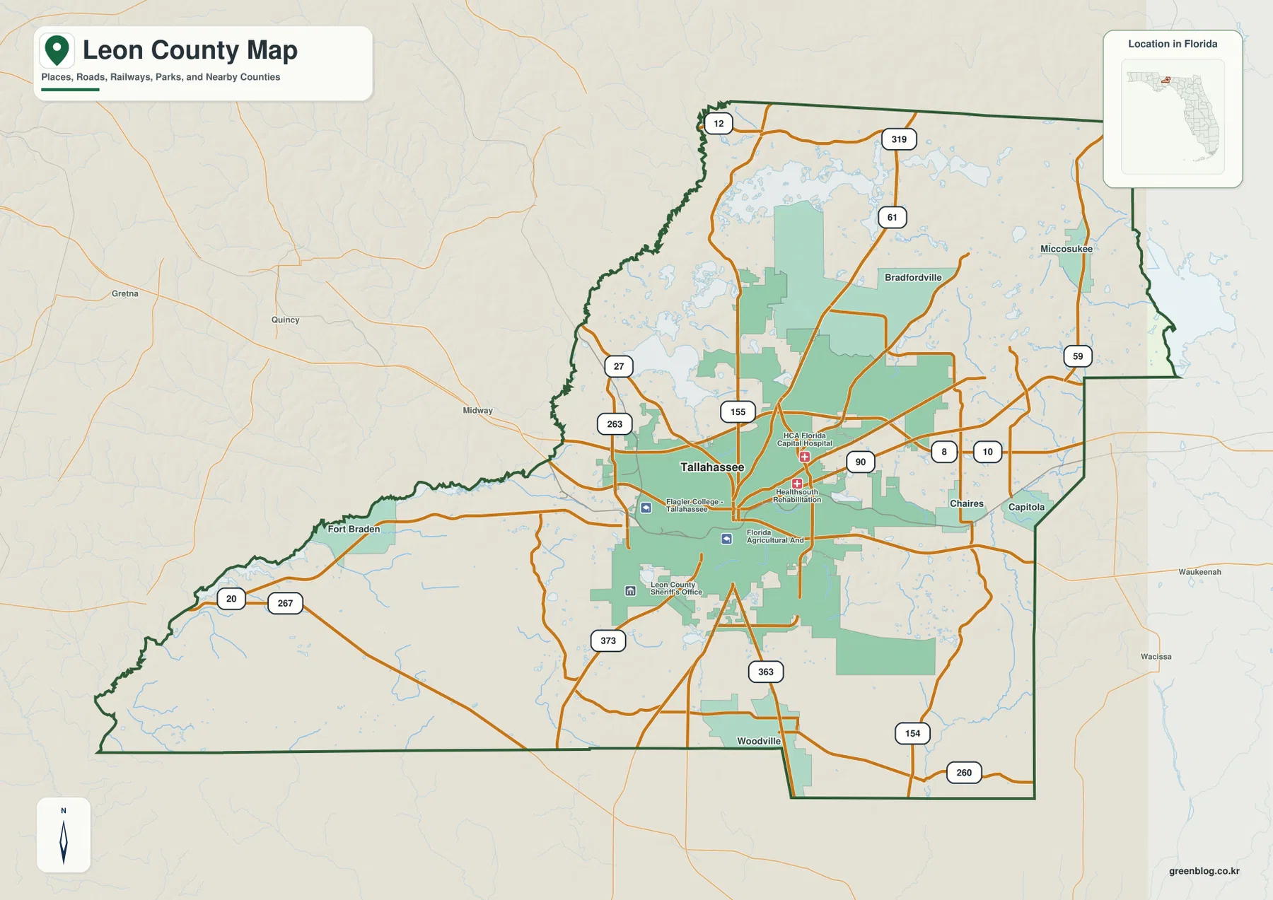
For a first look at the county, this is the most versatile of the supplied files. I-10 crosses east-west north of central Tallahassee, US 90 follows another east-west route through the urban area, and north-south highways connect the capital with Georgia and with communities toward Wakulla County. The map is also useful for seeing how quickly the road pattern thins outside Tallahassee, particularly across the large southwest corner.
One incorporated city, many recognizable place names
The city map tells a different story from the general map because its ranked city index contains only Tallahassee. That is not an omission. Leon County’s supplied background material states that Tallahassee is the county’s only incorporated city. Bradfordville, Miccosukee, Woodville, Fort Braden, and other names still matter when people describe where they live or travel, but they represent unincorporated communities or local areas rather than separate incorporated municipal governments.
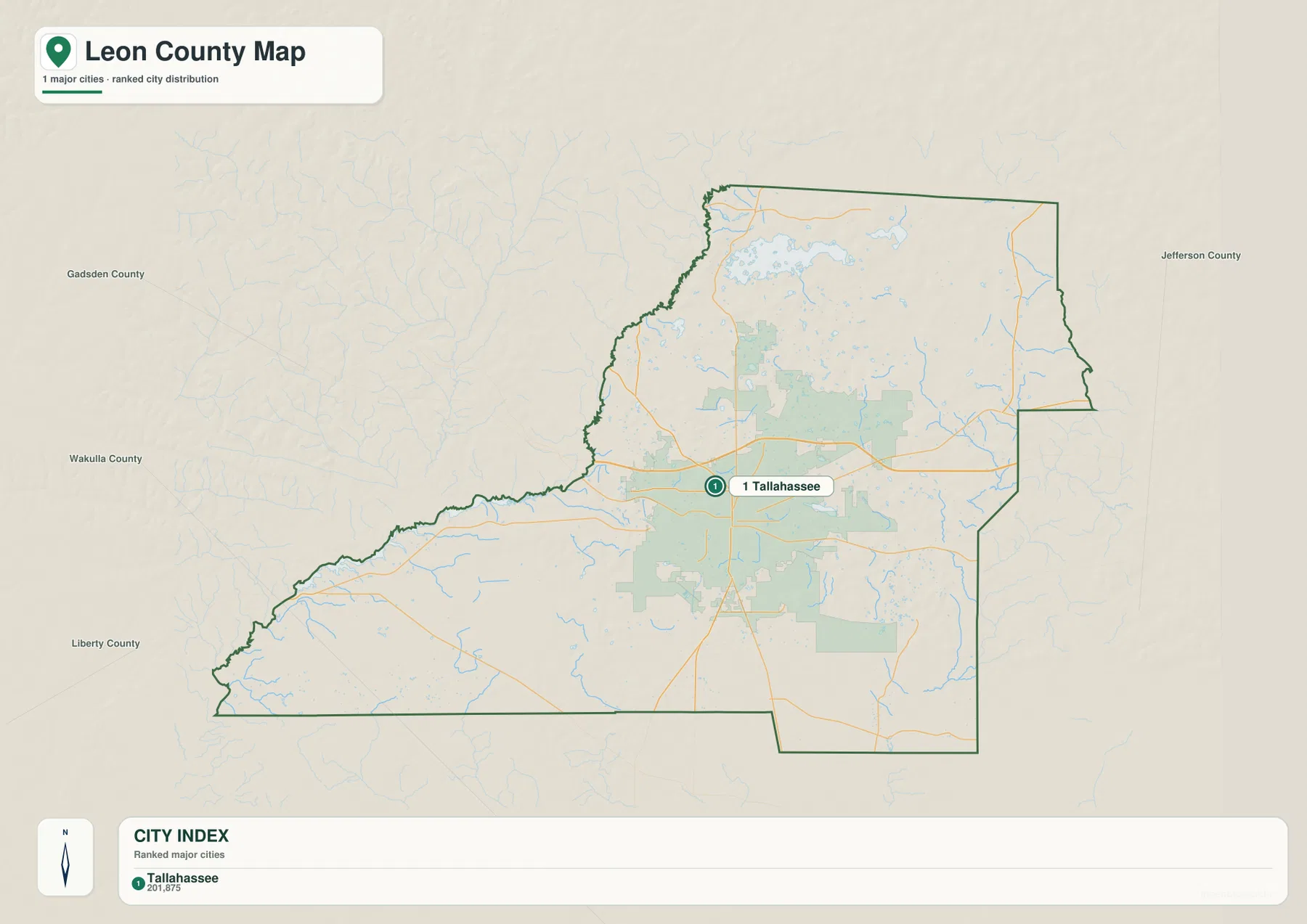
This single-city pattern helps explain the geography of the county. The Florida Capitol anchors downtown Tallahassee, Florida State University lies west of the central government district, and Florida A&M University is to the south. Government and higher education therefore occupy a compact central area compared with the wide county around it. Development continues north across I-10 toward Bradfordville and other suburban areas, but the city index still points back to one incorporated center rather than a chain of independent towns.
The city map is particularly helpful when a reader is confused by the many labels on the general map. A name printed beside a road or lake does not automatically mean that the place has its own city government. Looking at the city index beside the broader county map separates municipal status from ordinary geographic naming without removing useful local labels from the picture.
Lakes, creeks, and the Ochlockonee edge
Water is distributed across Leon County in a way that is easy to miss on a road-focused map. Lake Jackson is the most prominent labeled lake northwest of Tallahassee. Farther north, the water map labels Van Brunt Arm and Jake Hole, while Carr Lake, Mallard Pond, and Petty Gulf Lake appear across the northern interior. Lake Bradford and Lake Munson sit south of the urban center, and Lake Lafayette lies to the east. Instead of one continuous river corridor, much of the county shows a scattered pattern of lakes, ponds, and short drainage features.
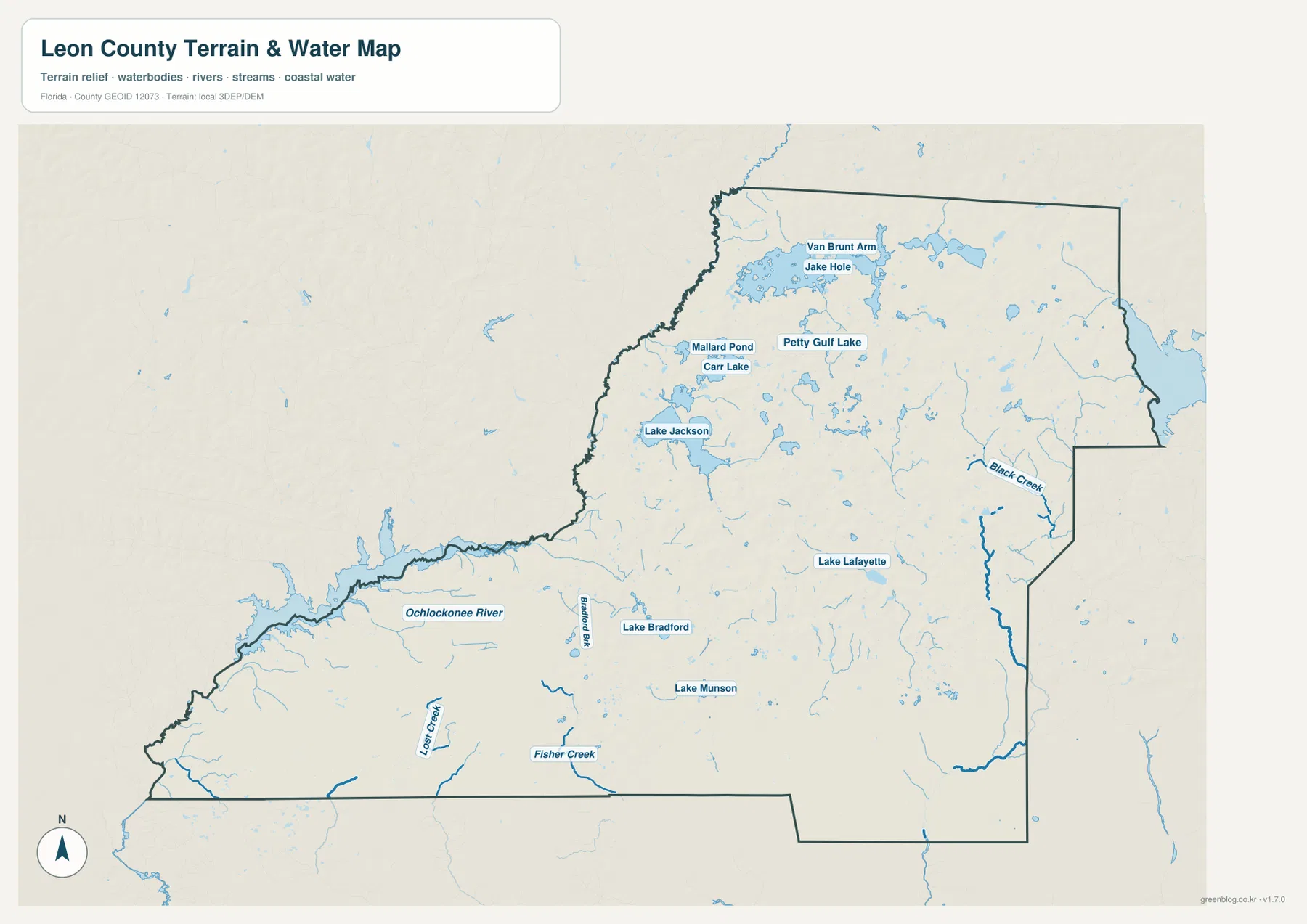
The strongest river feature appears along the western and southwestern side, where the Ochlockonee River follows part of the county edge. Smaller waterways such as Fisher Creek and Lost Creek are visible in the south, while Black Creek stands out along the eastern side. The map therefore reveals a contrast between the lake-rich north and center and the longer river and creek lines nearer the outer parts of the county.
Lake Jackson deserves a special caution because its shoreline is not always stable from one date to another. The supplied source material describes it as a karst lake affected by rainfall and sinkhole drainage. At times, water can retreat enough to expose parts of the lakebed. A current aerial image, an older map, and this reference map may therefore show different water extents without one of them necessarily being mislabeled. Anyone who needs present-day water levels or access conditions should check the managing agency’s current information.
How I-10 and the radial highways organize travel
I-10 provides the clearest regional east-west route. It passes north of central Tallahassee, connecting the Gadsden County side of the map with Jefferson County to the east. US 90 runs roughly parallel but has a more direct relationship with the city, entering Tallahassee under local street names including Tennessee Street and Mahan Drive. Seeing both routes on the same map prevents a common mistake: assuming that every east-west road through the capital serves the same purpose.
US 27 approaches Tallahassee from the northwest along Monroe Street, crosses the city, and continues southeast on Apalachee Parkway. US 319 enters from Georgia on Thomasville Road and later heads south as Crawfordville Highway toward Wakulla County. These local names are important because a traveler can follow the same numbered highway while the street name changes inside the urban area. Matching the route number with the local road name is more reliable than treating each name as a separate corridor.
SR 20 leads west toward Fort Braden and Liberty County, while Capital Circle links several of the highways around the outer part of Tallahassee. Access toward Tallahassee International Airport also branches through the southwestern road network. Together these routes create a pronounced contrast: a dense set of connections surrounds Tallahassee, while road spacing becomes much wider across forested and low-density areas farther southwest and south.
From Red Hills uplands to Leon Sinks and southern forest
Northern Leon County belongs to the Red Hills landscape described in the supplied county material. Rolling ground, red clay soils, lakes, and tree-lined roads distinguish this part of the county from the flatter pine country farther south. Leon County also describes 78 miles of protected canopy roads, where mature trees and adjoining protection areas preserve the wooded character of historic routes. This setting helps explain why northern suburban development can sit close to lakes and heavily vegetated roads rather than forming a uniform street grid.
South of Tallahassee, the geology becomes an important part of the story. Leon Sinks Geological Area contains sinkholes and underground passages formed in soluble limestone. The existing source material notes that dye tracing has demonstrated a hydrologic connection with Wakulla Spring farther south. In other words, the county boundary that is obvious on the administrative map does not act as a wall for groundwater moving through the limestone system.
The southwest also reaches forest associated with Apalachicola National Forest. The supplied article describes longleaf pine, cypress, tupelo, and palmetto communities in this broader landscape. That helps explain the relatively sparse development around Fort Braden and parts of the southern county compared with Tallahassee and the suburban corridors north of I-10. Leon County is therefore more than a capital-city county: northern lakes and hills, a concentrated urban center, sinkhole country, and extensive forest all appear within the same county outline.
Choosing the map that answers the question
Use the general county map when the main question involves roads, community names, county limits, or the relationship between Tallahassee and surrounding areas. It is the easiest file for following I-10, US 90, US 27, US 319, and SR 20 while keeping Bradfordville, Miccosukee, Chaires, Woodville, and Fort Braden in view. It also gives the clearest sense of how Leon County meets Georgia and its four neighboring Florida counties.
The city map is better for explaining why Tallahassee stands apart from the other place names. Its city index strips away much of the detail and shows the county’s incorporated urban hierarchy in one glance. The water map is the better choice for comparing Lake Jackson, Lake Lafayette, the Ochlockonee River, Black Creek, and smaller waterways because roads and urban labels no longer compete for attention.
None of the three files should be treated as a substitute for live navigation or regulatory mapping. Road construction, closures, lake levels, trail access, flood information, and property boundaries can change or require more precise data. The maps are designed to answer broader geographic questions and to provide clean printable references; official current sources should be consulted for decisions that depend on exact present-day conditions.
Frequently Asked Questions
Why does the city map list only Tallahassee?
Tallahassee is Leon County’s only incorporated city according to the supplied county material. Bradfordville, Miccosukee, Chaires, Woodville, Fort Braden, and other names are still useful geographic labels, but they are not separate incorporated municipalities. The city map therefore emphasizes Tallahassee while the general county map keeps the broader set of community names.
Why can Lake Jackson have a different shoreline on another map?
Lake Jackson is a karst lake affected by rainfall and sinkhole drainage, so its water level can change substantially. At some times, parts of the lakebed may be exposed. Maps or aerial images produced on different dates can therefore show different water extents, and current conditions should be checked through the managing agency when they matter for a visit.
Can this water map be used to identify flood zones or property boundaries?
No. It is a general reference for locating lakes, rivers, creeks, and the county outline. Flood-risk decisions, legal property boundaries, navigation, and engineering work require the appropriate current official datasets and should not be inferred from this simplified water reference map.
Map File Information
The ZIP contains the same three Leon County maps shown on this page as original high-resolution JPG files.
- Included Files: 3 high-resolution JPG maps
- File Type: ZIP
Related Maps
- Arcadia Roads and Peace River | DeSoto County Florida Map
- Baker County Florida Map
- Blountstown, SR 20, and the Apalachicola River | Calhoun County Florida Map
Sources
- Leon County Government: About Leon County
- Tallahassee-Leon County GIS
- Florida Department of Transportation: Leon County transportation profile
- Florida Department of Environmental Protection: Lake Jackson Aquatic Preserve
- U.S. Forest Service: Leon Sinks Geological Area
Green Map creates custom-edited map images using open geographic data sources such as geoBoundaries, Natural Earth, OpenStreetMap, and government open data. These maps are edited visual materials, not raw data files, and are provided for education, documents, presentations, and graphic reference.