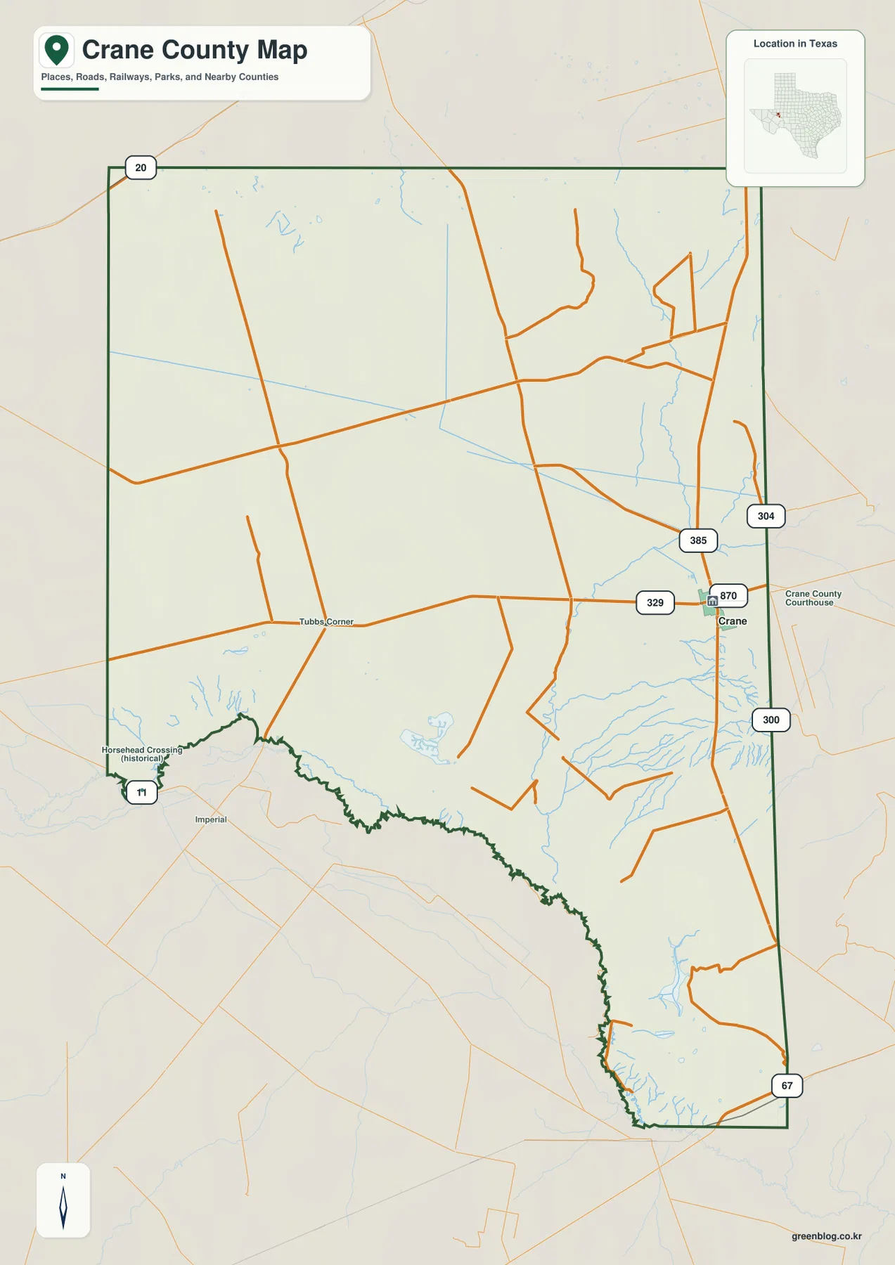
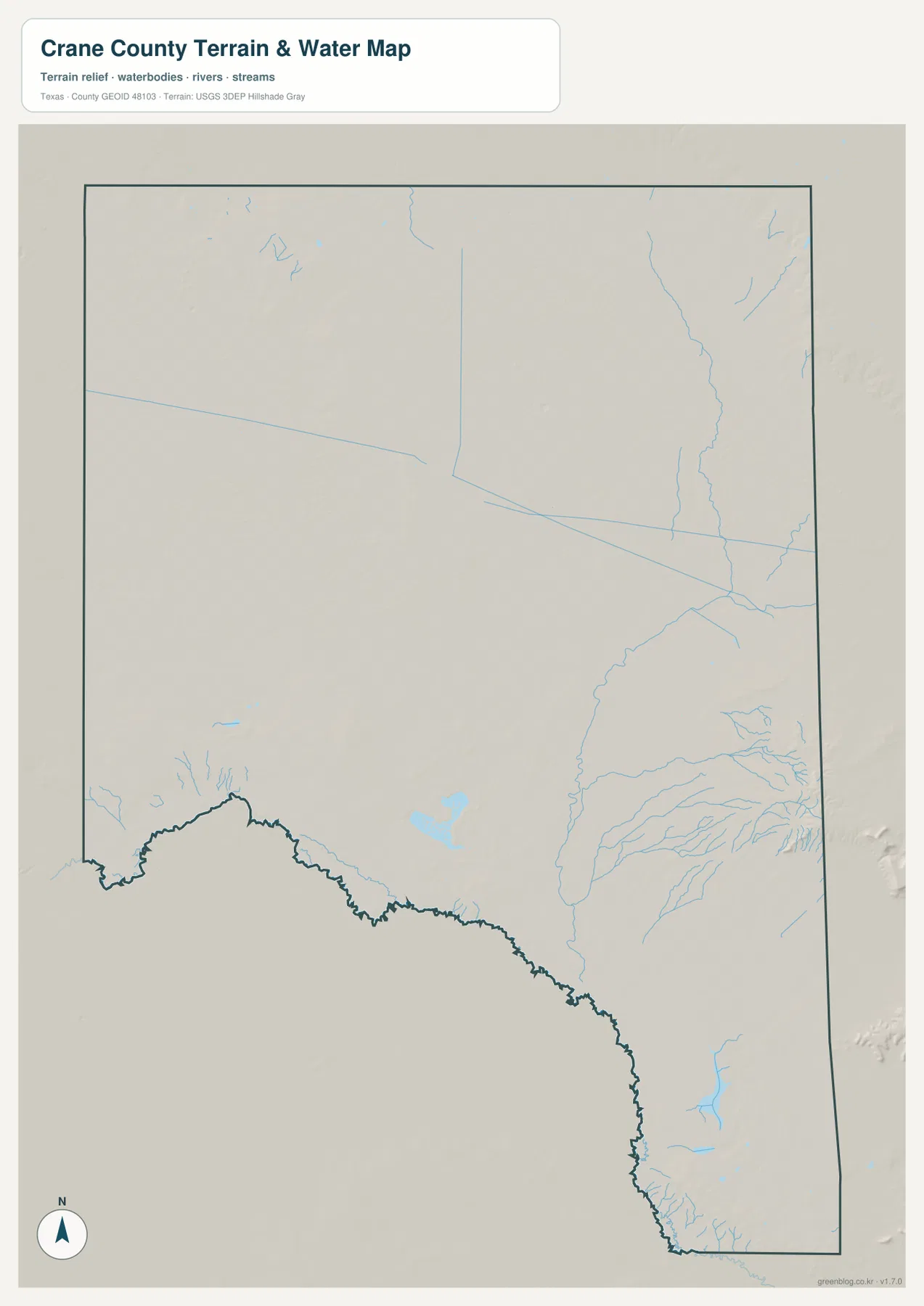
Crane County in West Texas has an unusual map balance: the city of Crane sits close to the eastern side, while most of the county stretches westward with very few settlement labels. US 385 runs north and south by Crane, Route 329 reaches west toward Tubbs Corner, and the general map also shows Horseshead Crossing as a historical place near the irregular southwestern boundary. The ranked city layer contains only Crane at 2,640. On the terrain-and-water image, small unnamed drainage channels and water bodies are most noticeable in the east and southeast rather than evenly spread across the county. The elevation map ranges from about 695 to 898 meters with a mean near 780 meters, showing high northern terrain and much lower ground toward the south. The county, city, water, and elevation maps shown here are also available together as four high-resolution JPG files in the ZIP download.
A practical way to read the map is to start at Crane, follow US 385 vertically, and then trace Route 329 west toward Tubbs Corner. Crane is not centered within the county outline; it sits close to the eastern boundary, so the western half appears much more open. Horseshead Crossing is labeled near the southwest edge, separated from Crane by a long stretch of sparse roads and settlement labels. That east-heavy settlement pattern is more distinctive on the supplied map than a broad regional description of the Permian Basin.
Table of Contents
Crane Sits at the Main US 385 and Route 329 Road Junction
Crane is the strongest place reference on the general county map. US 385 passes the town from north to south, while Route 329 approaches from the west and reaches the Crane area. Route 870 is labeled immediately east of town, and routes 304 and 300 provide additional references farther north and south along the eastern side. The concentration of numbered roads around Crane contrasts sharply with the sparse road pattern farther west.
Crane County Courthouse is labeled just east of the city, making the administrative center easy to identify. Because the town lies near the eastern side of the county, the surrounding-county relationship is also clear. The north is toward Ector County, the east toward Upton County, and the southeast toward Crockett County. Route 300 and Route 67 help orient the southern and southeastern edges.
Following Route 329 west leads to Tubbs Corner. There is no continuous built-up strip between the two labels; instead, a long road crosses an open interior with few named places. A separate north-south road intersects near Tubbs Corner, but the road density decreases again farther west. This part of the map communicates distance and openness more strongly than urban detail.
Horseshead Crossing is marked as a historical place near the southwestern boundary. The county outline in that area is winding and irregular, unlike the straighter northern and eastern sides. No major settlement corridor is shown between Horseshead Crossing and Crane, so the southwest is better understood by its boundary shape, sparse roads, and terrain than by a chain of towns.
The Ranked City Layer Contains One Major City: Crane 2,640
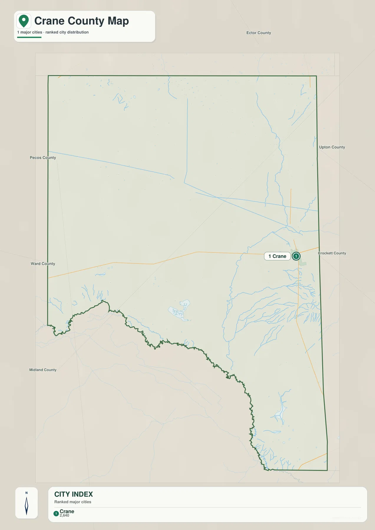
The ranked city map is intentionally minimal. Its header states that one major city is included, and the CITY INDEX lists only Crane at 2,640. Tubbs Corner and Horseshead Crossing remain useful labels on the general county map, but neither appears as a ranked city point. The result is a clear picture of a county with one dominant settlement reference and a very large rural interior.
Crane remains visibly close to the eastern boundary on this simplified layer. Ector County is labeled to the north, Upton County to the east, Crockett County to the southeast, and Pecos and Ward counties appear on the western side of the broader frame. Midland County is also labeled farther southwest in the surrounding view. These labels help show that Crane is not positioned at the geographic middle of the county.
No connector line or mileage label is printed on the city map. The value 2,640 should therefore be read only as the figure supplied in the CITY INDEX, not as a distance or travel-time number. For transportation, the general county map is the appropriate reference because it shows US 385, Route 329, and the other numbered roads. For the open land surrounding the city, the water and elevation layers add information that the one-point city map intentionally leaves out.
The absence of additional ranked cities does not mean the county has no geographic variation. Northern Crane County is substantially higher than the south, and small drainage channels become noticeably denser east and southeast of the city. Using Crane as a fixed point makes those physical changes easier to compare across the otherwise sparse map.
Small Drainage Channels Are Most Concentrated in the East and Southeast
The terrain-and-water map does not emphasize a large named river. Instead, it shows a thin network of small drainage channels and several small water bodies. The densest group lies around the eastern and southeastern part of the county, where multiple short channels branch near and south of the Crane area. Some run generally north-south, while others spread toward the eastern boundary.
The center and west look much sparser. A few short channels appear in the northwest, and isolated drainage lines cross the central interior, but they are widely separated compared with the east. Small tributaries also occur near the irregular southwestern boundary. The map therefore shows a clear difference in drainage density rather than one evenly distributed water network.
A few small water bodies are visible in the south-central interior, with another more noticeable water feature toward the southeast. The supplied preview does not label these features by name, so this article does not assign reservoir, lake, or river names that are not shown. Location-based descriptions—east of Crane, south-central interior, or near the southeastern side—stay within what the map actually supports.
This terrain-and-water image is for general geographic reference. It is not a flood-hazard map, parcel or legal-boundary map, depth chart, water-quality report, fishing-status guide, or navigation product. Those questions require specialized official information. For this page, the useful observation is the contrast between relatively dense small drainage in the east and southeast and much sparser channels across the western interior.
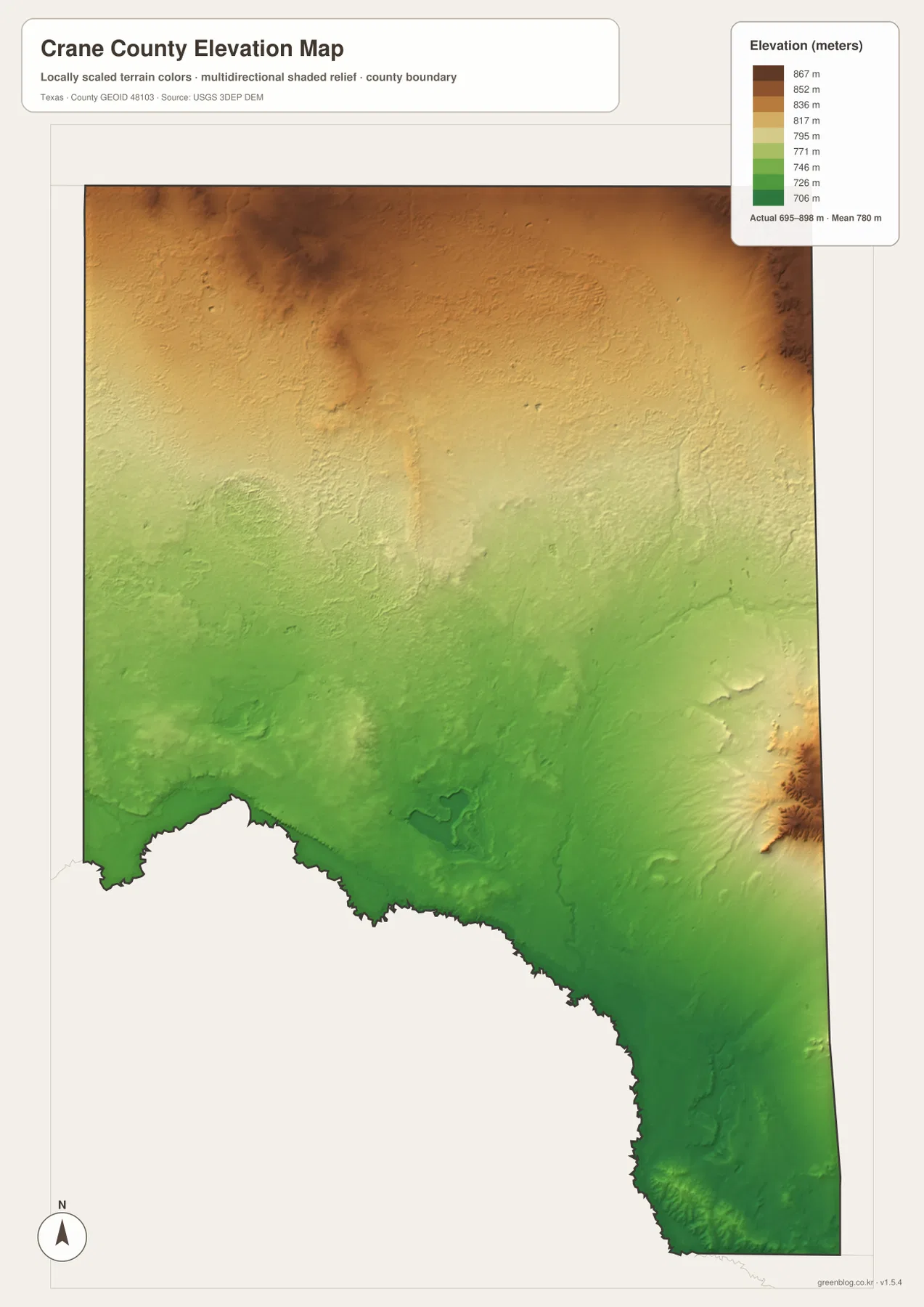
Elevation from About 695 to 898 Meters Drops Strongly Toward the South
The supplied elevation map reports an actual range of approximately 695 to 898 meters and a mean near 780 meters. The darkest brown high ground occupies much of the north, including broad areas along the north-central and northeastern side. The southern half is predominantly green and therefore lower. The north-to-south change is the clearest county-wide relief pattern visible on this layer.
The northern uplands are not perfectly level. Dark-brown and orange areas are interrupted by lower corridors and shallow valleys, especially through the north-central interior. Moving toward the middle of the county, the map shifts through yellow into light green as the overall surface drops. Areas that look almost featureless on the road map become much more varied once elevation is displayed.
One additional high area stands out near the east-central side. It rises in brown and orange above surrounding green terrain, so the county does not simply slope in one smooth direction from north to south. Farther south and southeast, lower green ground becomes dominant and several of the small drainage channels on the water map occupy those low corridors.
This elevation surface is suitable for county-scale comparison, not survey or engineering measurement. It should not be used to determine the precise elevation of an oilfield site, parcel corner, road grade, or construction location. The 695–898 meter range and 780 meter mean are best treated as broad reference values for comparing the northern uplands, the middle transition, and lower southern terrain.
Crane’s Eastern Road Cluster Contrasts with the Open Western Interior
The clearest way to understand Crane County is to compare the eastern Crane area with the Tubbs Corner side. Around Crane, US 385 and several numbered roads converge near the courthouse and built-up area. West along Route 329, settlement labels and road density fall away quickly. The county becomes visually defined by long distances, open terrain, and a small number of road intersections.
The physical layers add another distinction. Small drainage channels are more concentrated east and southeast of Crane, while the west-central area contains fewer visible channels. Elevation also varies strongly from the high north to the low south, with a separate east-central ridge adding local relief. Horseshead Crossing in the southwest sits in yet another setting, near the irregular boundary and lower southern terrain.
The supplied current article identifies Crane County as part of the southern Permian Basin, which is useful regional background. This rewrite gives priority to features that are directly visible on the county maps: Crane’s eastern position, US 385 and Route 329, the single-city ranking, sparse western drainage, and the 695–898 meter elevation range. Those details distinguish this county from other Permian Basin pages that might otherwise sound nearly identical.
Choose the File by Roads, Crane Location, Drainage, or Elevation
The general county map is the best single reference for Crane, Tubbs Corner, Horseshead Crossing, US 385, Route 329, and the other numbered roads. The ranked city map is deliberately simple and works best when the goal is to locate Crane and view its CITY INDEX value. The terrain-and-water map is useful for comparing the denser small drainage network in the east and southeast with the sparse western interior. The elevation map most clearly shows the high north, lower south, and the separate elevated feature near the east-central side.
Thin drainage lines and small route labels can be difficult to read in the reduced browser previews. The high-resolution JPG files are more convenient for enlargement and printing. They can also be placed beside maps of Ector, Upton, Crockett, Pecos, Ward, or other West Texas counties to compare the position of Crane and the north-to-south elevation change on a consistent map type.
The ZIP below contains four high-resolution JPG files corresponding to the county, city, water, and elevation maps shown in the article. They can be enlarged for detailed label reading, printed for classroom or personal reference, or used for county-to-county comparison.
Frequently Asked Questions
Why does the ranked city map show only Crane?
The supplied ranked-city layer contains one major city, Crane at 2,640. Tubbs Corner and Horseshead Crossing are visible on the general county map but are not ranked city points, and no mileage connectors are shown.
Which part of Crane County is highest on the supplied elevation map?
The north contains most of the highest terrain. The supplied map reports an elevation range of about 695–898 meters with a mean near 780 meters, while the southern half is generally lower and an additional high ridge appears near the east-central side.
Why are specific river or lake names not used for the water map?
The supplied preview shows small drainage channels and water bodies but does not label most of them by name. To avoid inventing unsupported features, this article describes their visible location and density instead of assigning names that are not present in the source map.
Sources and Reference Data
- U.S. Census Bureau TIGER/Line Shapefiles — official geographic boundary, road, and place data.
- USGS National Hydrography — official information about streams, drainage, and water features.
- USGS 3D Elevation Program — official elevation and terrain data information.
- USGS The National Map Viewer — interactive access to boundaries, transportation, hydrography, terrain, and other geographic layers.
Map File Information
Download the Crane County county, city, water, and elevation maps together as high-resolution JPG files.
- Included Files: 4 maps
- File Type: JPG
Related Maps
- Pecos County Texas map
- Upton County Texas map
- Ward County Texas map
- Reagan County Texas map
- Schleicher County Texas map
Green Map creates custom-edited map images using open geographic data sources such as geoBoundaries, Natural Earth, OpenStreetMap, and government open data.
These maps are edited visual materials, not raw data files, and are provided for education, documents, presentations, and graphic reference.