This Schleicher County Map set focuses on the features that are actually visible in the supplied material: Eldorado as the main settlement reference, a broad road network crossing the county, South Concho River and Dry Devils River in different drainage areas, several named creeks and prongs, and an elevation surface that is highest in the west and northwest. The four maps can be viewed in the article, and high-resolution A3 JPG versions are available together in the download box below.
Schleicher County is not a place where a dense group of towns dominates the page. Instead, Eldorado acts as the central landmark inside a large, mostly open county outline. Roads extend in several directions from the interior, while the water map reveals separate valleys in the north, southwest, and east. The elevation map adds a final piece of context by showing higher plateau country in the west stepping down toward lower valleys on the eastern side.
Table of Contents
Eldorado is the most useful anchor for the road network
On the general reference map, Eldorado sits slightly west of the county’s center and provides the easiest place to begin. Roads labeled 190 and 117 approach from the west, while 277 runs south from the Eldorado area. The northern and northwestern sections contain routes 412, 915, 418, and 427. Once Eldorado is located, these labels make the upper and western parts of the county much easier to orient.
East of Eldorado, routes 300 and 316 are prominent in the central-northern area. Farther east, 350 and 339 help identify the northeastern road pattern. Route 220 appears southeast of the center, with 245 and 864 farther toward the southeastern corner. Route 119 is visible in the southwest near the 190 corridor. The most useful way to read these roads is not as a list but as branches extending outward from the central Eldorado reference point.
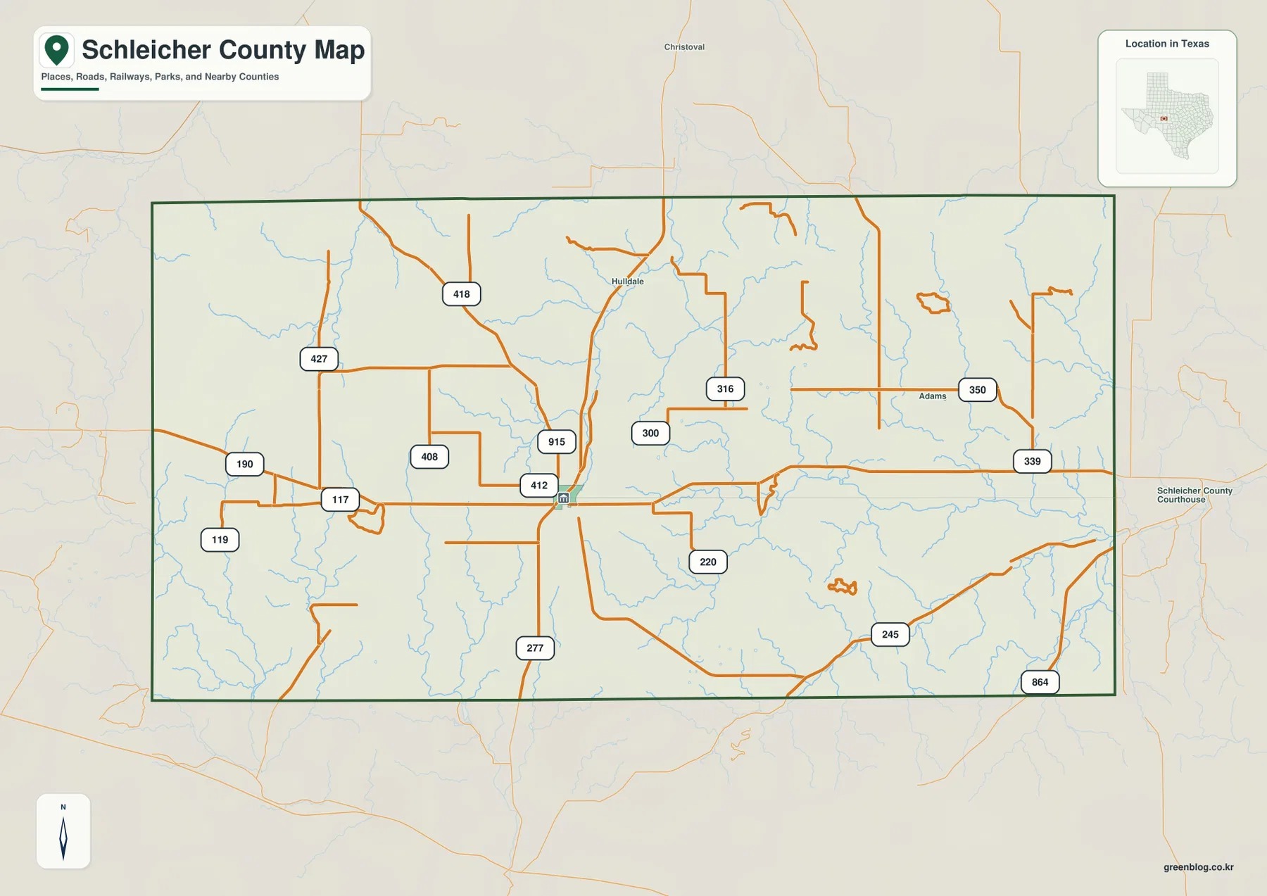
The county boundary is comparatively regular, but the interior stream network is not. Christoval is labeled north of the county, and the map also shows smaller place references such as Hulldale and Adams. An exterior Schleicher County Courthouse label appears to the east. These labels are useful for orientation because they provide local reference points beyond Eldorado without changing the basic fact that Eldorado is the dominant mapped settlement.
The city map emphasizes one major settlement rather than a town hierarchy
The ranked city map highlights only Eldorado. It is marked as number 1 near the middle of the county, and the CITY INDEX lists Eldorado at 1,737. Because no second major city is ranked on this map, the purpose is not to compare several town populations or travel distances. It is better read as a simplified location map that shows where Eldorado sits inside the county.
The surrounding county names become especially useful in this simplified view. Tom Green County is labeled to the north, Irion County to the northeast, Menard and Concho counties to the east, and Kimble County toward the southeast. Sutton County is shown on the west side, with Crockett County to the southwest. This frame makes Schleicher County’s regional position clear even though the city layer itself contains only one ranked settlement.
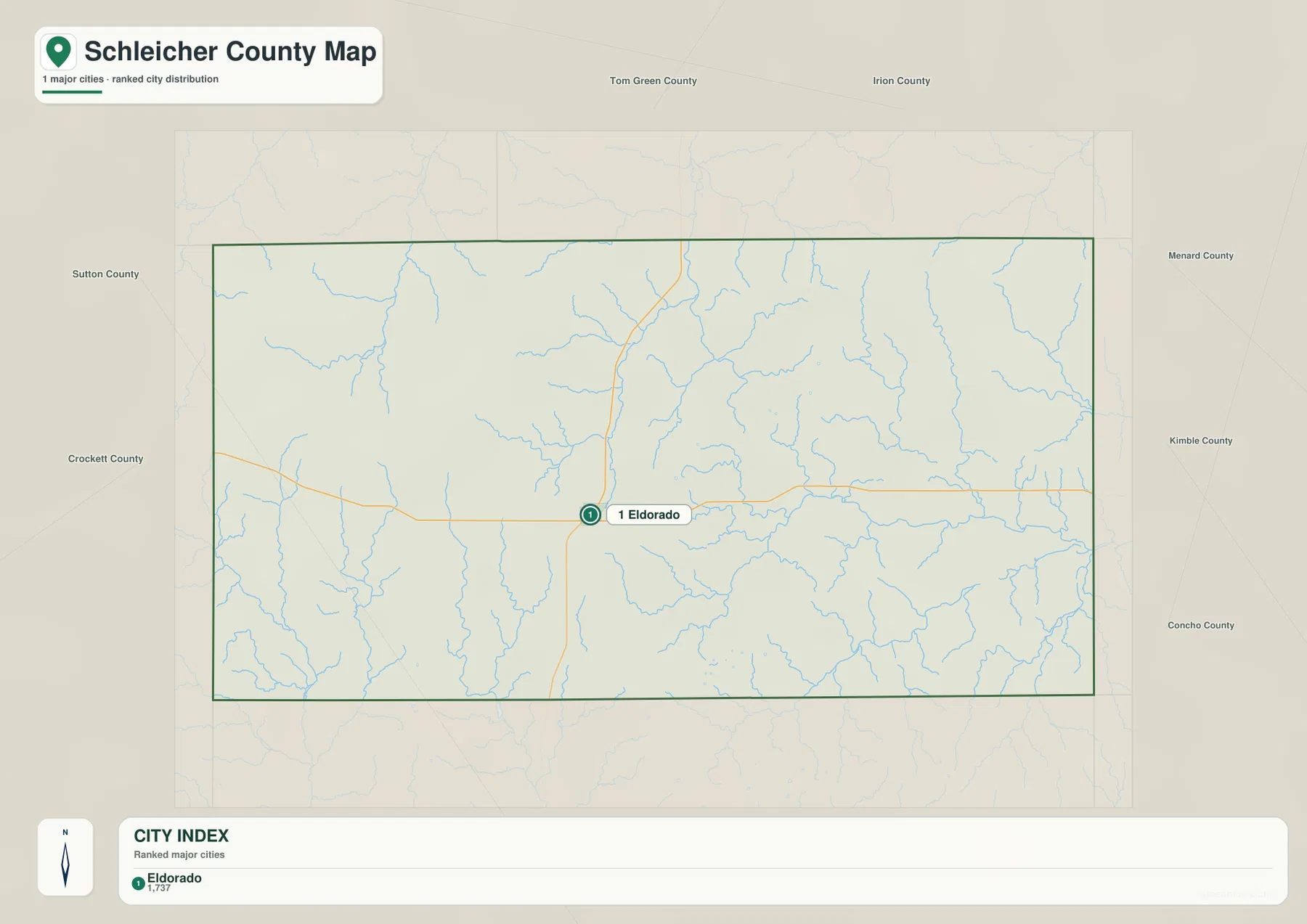
This version is useful for a county overview, classroom page, or presentation that needs one clean settlement marker without a dense road layer. The map still keeps the county outline and water network in the background, so Eldorado remains connected to the surrounding geography rather than appearing as an isolated dot.
South Concho River and Dry Devils River occupy different parts of the county
The terrain-and-water map changes the focus from roads to drainage. South Concho River is one of the strongest labeled channels in the north-central part of the county. Dove Creek is shown farther northwest. In the southwest, Dry Devils River follows a separate valley toward the southern boundary, with smaller tributaries joining it along the way.
The eastern half has another recognizable set of named channels. North Valley Prong extends across the central-east, and Middle Valley Prong runs farther south in a broadly similar direction. Rocky Creek is labeled in the northeast. Numerous smaller unnamed channels fill the spaces between them, creating a dense branching pattern that is much easier to follow on the water map than on the road-focused reference map.
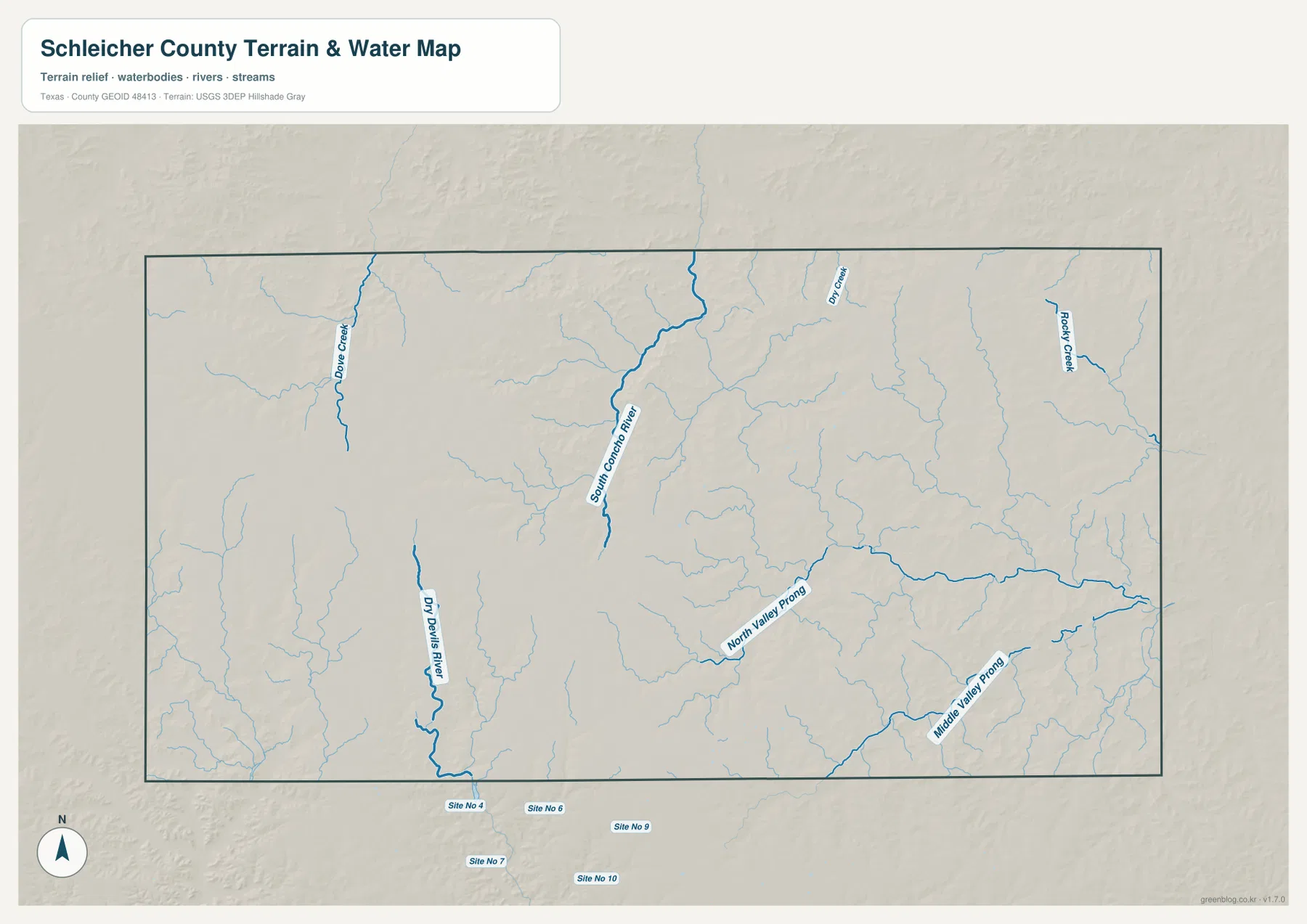
The simplest way to read the drainage is to begin with the two widely separated river labels. South Concho River provides a northern reference, while Dry Devils River identifies the southwest. North Valley Prong and Middle Valley Prong then define much of the eastern drainage pattern. This map is a geographic water reference, not a flood-risk, parcel, legal-boundary, or navigation product.
Higher western plateau terrain descends into lower eastern valleys
The elevation map reports an actual range of about 634 to 794 meters and a mean elevation of 722 meters. The darkest brown terrain is concentrated in the west and northwest, where broad high ground and short ridges dominate the surface. Moving toward the center, the colors shift through tan and yellow-green. The east and southeast contain larger areas of green, indicating lower terrain.
The change in height is not a smooth, featureless slope. Narrow green valleys cut into the higher plateau, and the eastern half contains many branching low corridors. When the elevation map is compared with the water map, those corridors align with the same general pattern of creeks, rivers, and prongs. This makes the relationship between drainage and relief easier to understand than it would be from the elevation numbers alone.
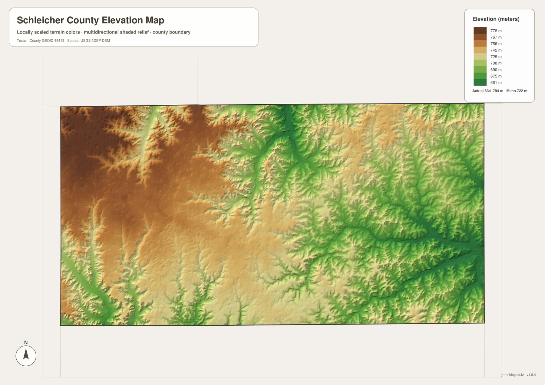
This countywide elevation surface is intended for broad terrain comparison rather than parcel surveying or engineering design. It is useful for seeing which side of the county is relatively high, where lower valleys cut through the plateau, and why many of the mapped waterways follow those corridors. A project that requires a precise elevation at a specific site should use the underlying source data or a detailed local survey.
Choosing the clearest map for roads, Eldorado, water, or relief
Use the county reference map when you need Eldorado, route numbers, the county boundary, and smaller surrounding labels in one view. The city map is better when the goal is a simple presentation of Eldorado as the primary mapped settlement. Choose the water map for South Concho River, Dry Devils River, Dove Creek, North Valley Prong, Middle Valley Prong, and Rocky Creek. The elevation map is the clearest choice for comparing the high western plateau with the lower eastern valleys.
The WebP images in the article are convenient for quick on-screen viewing. For printing or editing, the ZIP below contains four matching high-resolution A3 JPG files: the county reference map, city map, terrain-and-water map, and elevation map. Keeping them as separate files makes it easy to print only the layer needed for a lesson, county reference sheet, presentation, or personal project.
Frequently Asked Questions
Where is Eldorado on the Schleicher County map?
Eldorado is slightly west of the county’s center and is the main settlement reference on the supplied maps. Route 277 extends south from the area, roads 190 and 117 approach from the west, and several numbered roads continue toward the north and east.
Are South Concho River and Dry Devils River in the same part of the county?
No. South Concho River is labeled in the north-central part of the water map, while Dry Devils River is in the southwest. The eastern half also has separate drainage corridors marked North Valley Prong and Middle Valley Prong.
What elevation range is shown for Schleicher County?
The supplied elevation map states an actual range of about 634 to 794 meters and a mean of 722 meters. The west and northwest are generally higher, while lower green valleys become more prominent toward the east and southeast.
Map File Information
The ZIP contains the four Schleicher County maps in high-resolution A3 JPG format.
- Included Versions: County reference, city, terrain and water, elevation
- Included Files: 4 A3 JPG maps
Related Maps
Sources and data references
County boundaries and road reference data can be checked through the U.S. Census Bureau TIGER/Line Shapefiles. Rivers, creeks, and other hydrographic features can be cross-checked with USGS National Hydrography, while elevation data are available through the USGS 3D Elevation Program. The city index value, road numbers, named waterways, and elevation figures described above are based on the Schleicher County maps supplied in the current ZIP package.
Green Map creates custom-edited map images using open geographic data sources such as geoBoundaries, Natural Earth, OpenStreetMap, and government open data.
These maps are edited visual materials, not raw data files, and are provided for education, documents, presentations, and graphic reference.