This Scurry County Map set uses Snyder as the main reference point for understanding roads, nearby places, creek valleys, and terrain across the county. Hermleigh appears southeast of Snyder, Fluvanna is toward the northwest, and the water map adds Deep Creek, Rough Creek, the Colorado River, and the Clear Fork Brazos River. For printing or editing, the download box later on this page provides the four supplied maps as high-resolution A3 JPG files in one ZIP.
Scurry County becomes much easier to understand when the maps are read together. The road map shows Snyder as the central junction, while the water map replaces straight highway lines with a dense network of branching creeks. The elevation map then explains much of that drainage pattern: the northwest contains the highest ground, whereas lower valleys are widespread in the northeast and south. Each view adds information that is difficult to see clearly on the others.
Table of Contents
Snyder anchors the road network and the surrounding place names
On the general county map, Snyder lies near the center and is the easiest place to begin. Route 84 passes through the Snyder area and continues southeast toward Hermleigh. Route 180 forms another strong east-west line through the central part of the county. From the north, 208 approaches Snyder, while 350 reaches the southern boundary from the southwest. Reading these routes outward from Snyder is more useful than treating the numbers as an isolated list because their directions become immediately clear.
Hermleigh is separated from Snyder to the southeast, providing a clear reference for the lower-right part of the county. Fluvanna appears much farther northwest near the western side. Outside the county, Inadale is labeled beyond the southeast edge, with Colorado City and Loraine farther south. The Snyder area receives additional detail, including Winston Field and Cogdell Memorial Hospital, which makes the central settlement stand out from the more open surrounding landscape.
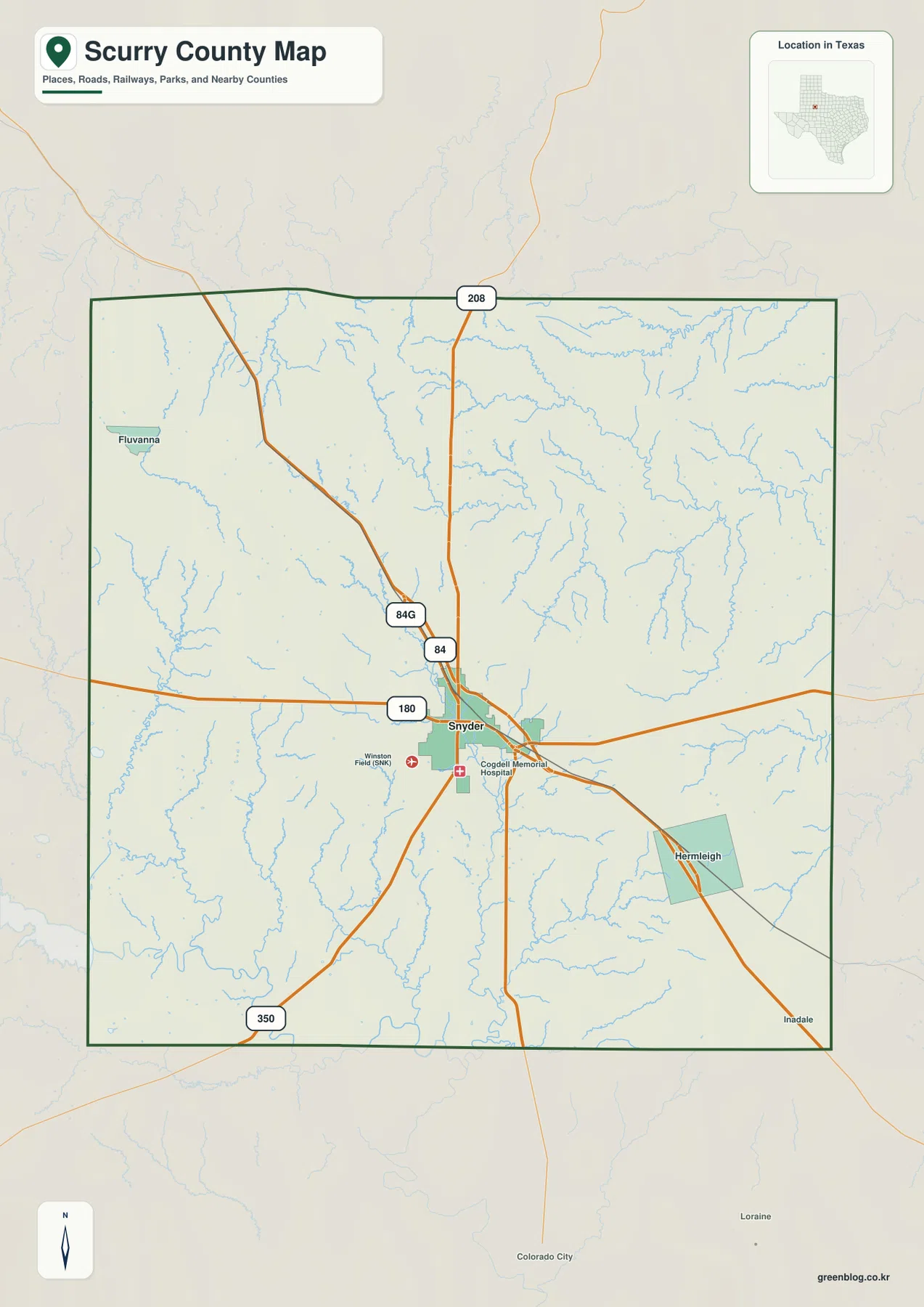
The county outline itself is comparatively simple, but the interior drainage is not. Small blue channels branch across nearly every section, especially in the northeast and southwest. That contrast is useful when moving between the maps: the reference map is best for roads and settlements, while the terrain-and-water map gives those same areas a much more detailed natural framework.
The city map treats Snyder as the single major urban reference
The ranked city map highlights only Snyder. It is marked as number 1, and the CITY INDEX prints a value of 11,241. No second major city is ranked in the supplied graphic, so this version is not intended as a multi-city comparison. Instead, it provides a clean view of where Snyder sits inside the county when roads and smaller place labels are reduced.
The simplified layout also makes the neighboring county labels easier to read. Kent County is shown to the north, Fisher and Nolan counties lie along the eastern side, and Howard County is farther southeast. Mitchell and Garza counties appear to the west, with Borden County toward the southwest. These surrounding names help place Snyder and Scurry County within the broader West Texas region without requiring a separate regional map.
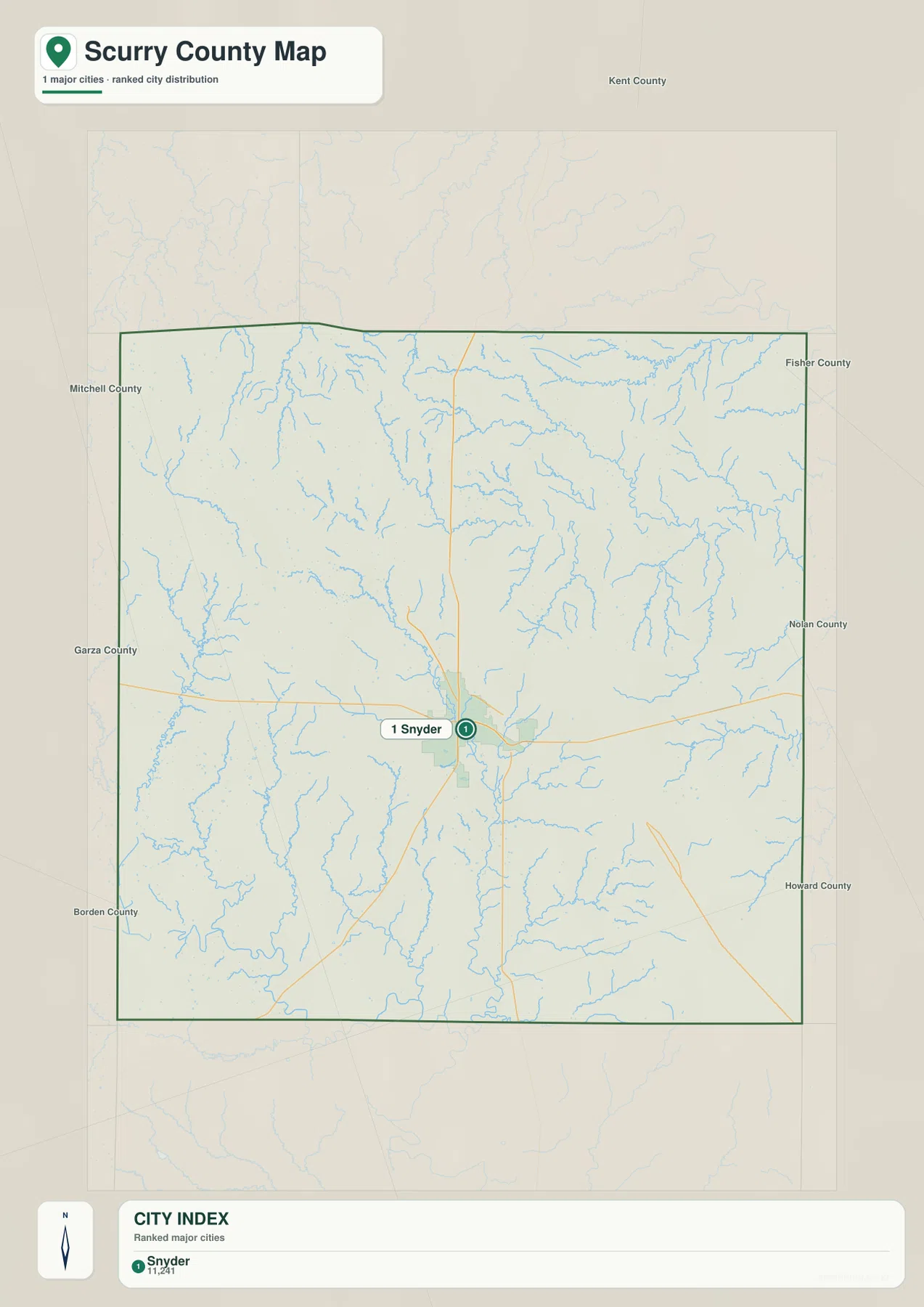
This city map works well for a classroom page, presentation, or county overview where a clear settlement marker matters more than detailed navigation. Once Snyder is fixed in the reader’s mind, Hermleigh and Fluvanna are easier to place when returning to the fuller county map. The CITY INDEX number should be read as the value printed on this supplied map; current demographic work should use an official statistical source.
Deep Creek provides the clearest line through the central drainage network
On the terrain-and-water map, Deep Creek is one of the strongest named channels. It enters from the western side, crosses the central part of the county, and continues toward the south-central interior while receiving many smaller tributaries. In the north, Little Rough Creek and Rough Creek form another prominent drainage line, and Ennis Creek crosses the north-central area below them. The water network is far more intricate than the road map suggests.
The southwest contains the Colorado River near the county corner, with Bull Creek and Chimney Creek among the nearby named tributaries. On the eastern side, Camp Creek runs through a separate valley and the Clear Fork Brazos River appears as a distinct bold watercourse farther southeast. Canyon Creek and Big Sulphur Creek are labeled in the southern half. Together, these features show that Scurry County is divided among several drainage directions rather than organized around a single river.
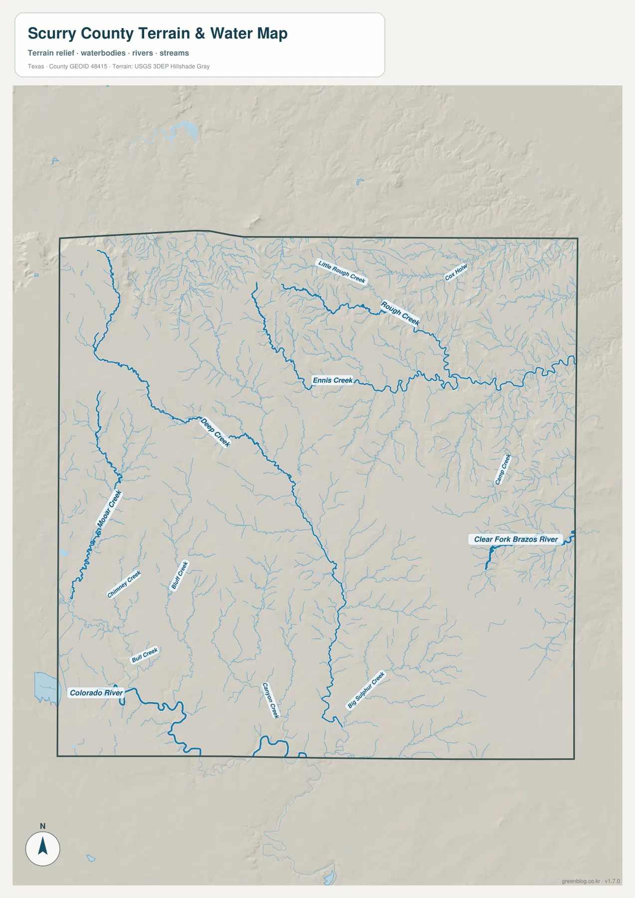
A practical way to read this map is to use four broad references: Deep Creek in the center, the Rough Creek system in the north, the Colorado River in the southwest, and the Clear Fork Brazos River on the eastern side. Smaller creeks fill the valleys between them. This is a geographic water reference map, not a flood-risk, parcel-boundary, legal, or navigation product.
The highest terrain is concentrated in the northwest
The elevation map states an actual range of about 571 to 868 meters and a mean elevation of 721 meters. The darkest brown colors, representing the highest ground, are concentrated in the northwest and upper western side. Tan and yellow areas extend from that high terrain toward the center. In contrast, broad green valleys occupy much of the northeast, and lower green corridors also appear across the south and southwest.
The county does not slope evenly in one direction. Broad uplands are cut by narrow branching valleys, creating a surface that changes repeatedly over short distances. When the elevation map is compared with the water map, many of the green corridors match the same general directions followed by Deep Creek and smaller tributaries. This connection between drainage and relief is more informative than the maximum and minimum elevation numbers alone.
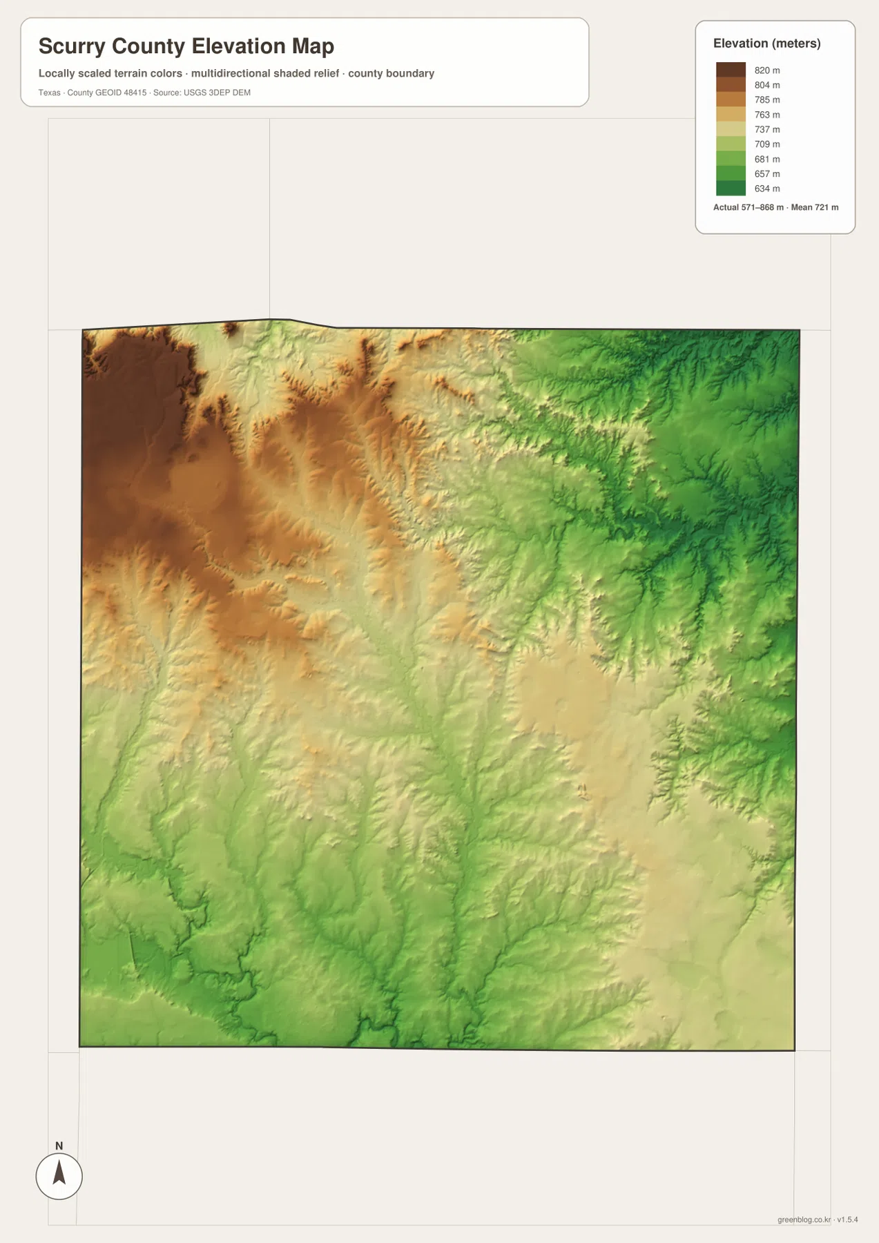
This countywide elevation surface is intended for broad terrain comparison rather than survey or engineering work. It is useful for seeing which areas are relatively high, where lower creek valleys cut through the uplands, and how the terrain changes across the county. A project that requires the precise elevation of a specific parcel or structure should use detailed source data or a local survey instead.
Choosing the map that best fits the question
Use the county reference map when you need Snyder, Hermleigh, Fluvanna, route numbers, and the county boundary in one view. The city map is cleaner when Snyder alone needs to stand out. Choose the water map for Deep Creek, the Colorado River, Rough Creek, or the Clear Fork Brazos River, and use the elevation map when the contrast between high northwestern terrain and lower creek valleys matters most.
The WebP images in the article are convenient for quick viewing. For printing or editing, the ZIP below contains the four matching maps as high-resolution A3 JPG files: county reference, city, terrain and water, and elevation. Because the files remain separate, you can print only the map needed for a classroom handout, local reference sheet, presentation, or personal project.
Frequently Asked Questions
Where is Hermleigh in relation to Snyder?
On the supplied county map, Hermleigh is southeast of Snyder. Route 84 continues from the Snyder area toward Hermleigh, making the relationship easy to follow on the road map.
Which waterways stand out on the Scurry County water map?
Deep Creek is a strong central reference. Rough Creek and Ennis Creek are prominent in the north, the Colorado River is labeled in the southwest, and the Clear Fork Brazos River appears on the eastern side.
What elevation range is shown for Scurry County?
The supplied elevation map reports an actual range of about 571 to 868 meters and a mean of 721 meters. The northwest contains the highest terrain, while lower valleys are widespread in the northeast and south.
Map File Information
The ZIP contains the four Scurry County maps in high-resolution A3 JPG format.
- Included Versions: County reference, city, terrain and water, elevation
- Included Files: 4 A3 JPG maps
Related Maps
Sources and data references
County boundaries and road reference data can be checked through the U.S. Census Bureau TIGER/Line Shapefiles. Rivers, creeks, and other hydrographic features can be cross-checked with USGS National Hydrography, while elevation data are available through the USGS 3D Elevation Program. The city index value, road numbers, named waterways, and elevation figures described above are based on the Scurry County maps supplied in the current ZIP package.
Green Map creates custom-edited map images using open geographic data sources such as geoBoundaries, Natural Earth, OpenStreetMap, and government open data.
These maps are edited visual materials, not raw data files, and are provided for education, documents, presentations, and graphic reference.