This page uses Sanderson as the main road reference for a Terrell County Texas Map, then follows the county’s desert creeks and dramatic elevation changes across a much larger landscape. Download the high-resolution A3 JPG map ZIP from the box below when you need printable or editable files. This package contains only the county-reference, terrain-and-water, and elevation maps; there is no city map in the current Terrell County asset set.
Terrell County looks sparse on a settlement map, but the terrain is anything but simple. Sanderson sits in the southwestern part of the county near the U.S. 90 corridor, while the interior is divided by long creek valleys and steep uplands. The elevation map shows an unusually large range from about 359 to 1,137 meters. High western and southwestern ridges stand far above broad lower terrain in the south and east, and the existing article material also describes the county’s southern border as Rio Grande canyon country.
Table of Contents
Sanderson provides the clearest road reference
Sanderson is the easiest place to begin on the county reference map. U.S. 90 passes through the Sanderson area and continues east across the lower half of the county, with 90W and 90E labels visible on opposite sides. U.S. 285 extends north from the Sanderson side, and 285S is also marked nearby. Route 349 branches northward farther east, providing a useful road reference for the central interior.
Emerson is labeled west of Sanderson, while Moser appears much farther north in the central interior. Dryden Crossing is marked along the southern boundary, giving the map a clear border-side reference below the main road corridor. Sheffield is visible beyond the northeastern side, and a Terrell County Courthouse label appears outside the eastern edge. Rather than treating those names as an isolated list, it is easier to use Sanderson as the anchor and compare the western, northern, and southern directions from there.
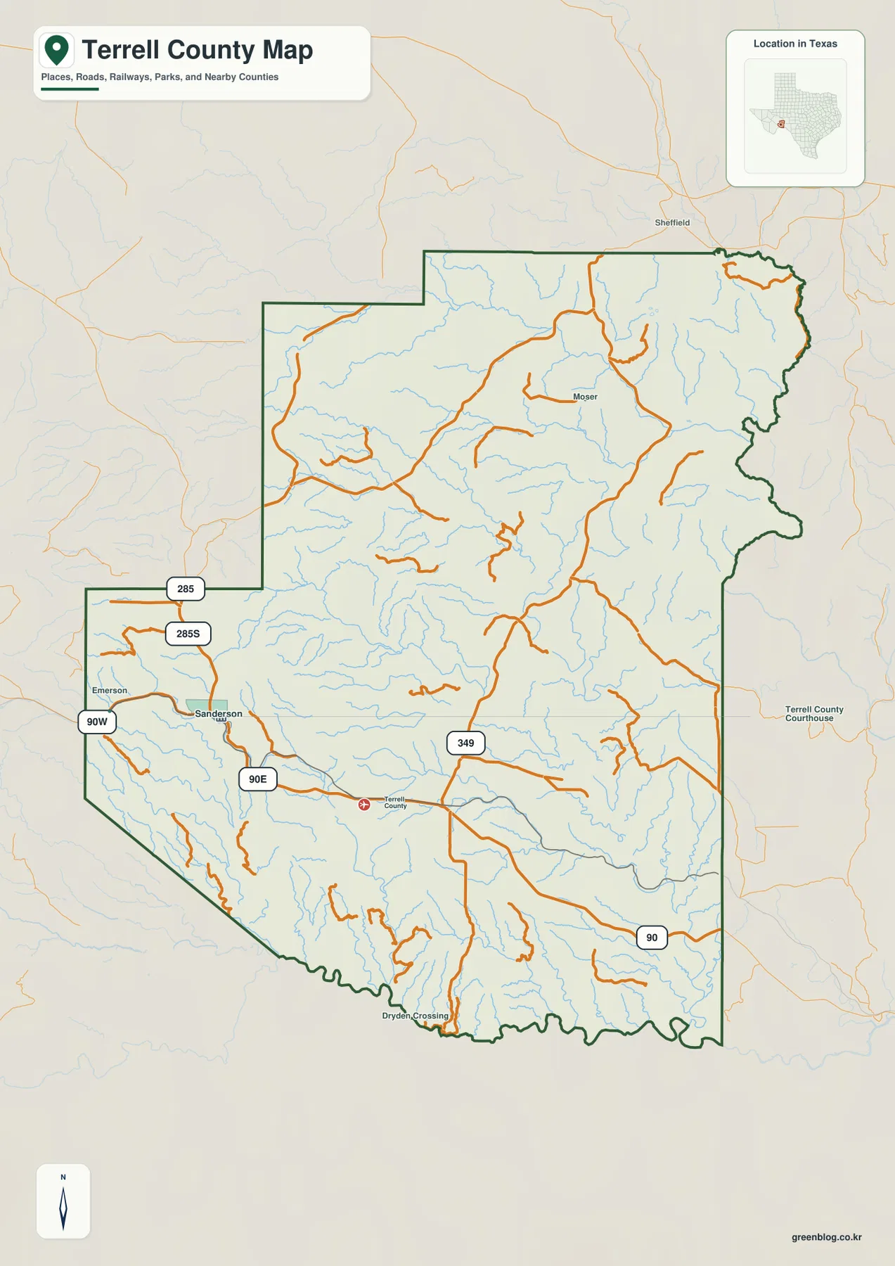
The road layer is crossed by far more drainage lines than settlement labels. Thin blue channels branch through the north and center, while longer valleys cut toward the southern edge. The highways remain comparatively direct, so the contrast between road geometry and natural drainage immediately suggests a rugged landscape rather than a flat desert plain.
Independence Creek and Sanderson Creek drain very different parts of the county
The terrain-and-water map gives the northern half several strong named references. Independence Creek follows a broad channel in the northeast, with Mitchell Creek approaching from the west. Dry Creek forms another long valley farther south, and McKay Creek crosses the west-central interior. Together they show how the higher northern uplands are cut by repeated drainage corridors.
The southwestern side is organized around Sanderson Creek, which bends through a long valley toward the southern border. Roman Draw and Buck Creek occupy nearby low corridors. Prairie Creek becomes a useful reference in the south-central interior, while the southeast contains a closely spaced group of Indian Creek, Cook Creek, Coon Creek, and Cedar Creek. Big Fodders Creek is labeled farther north on the eastern side, separating that drainage from the lower southeastern group.
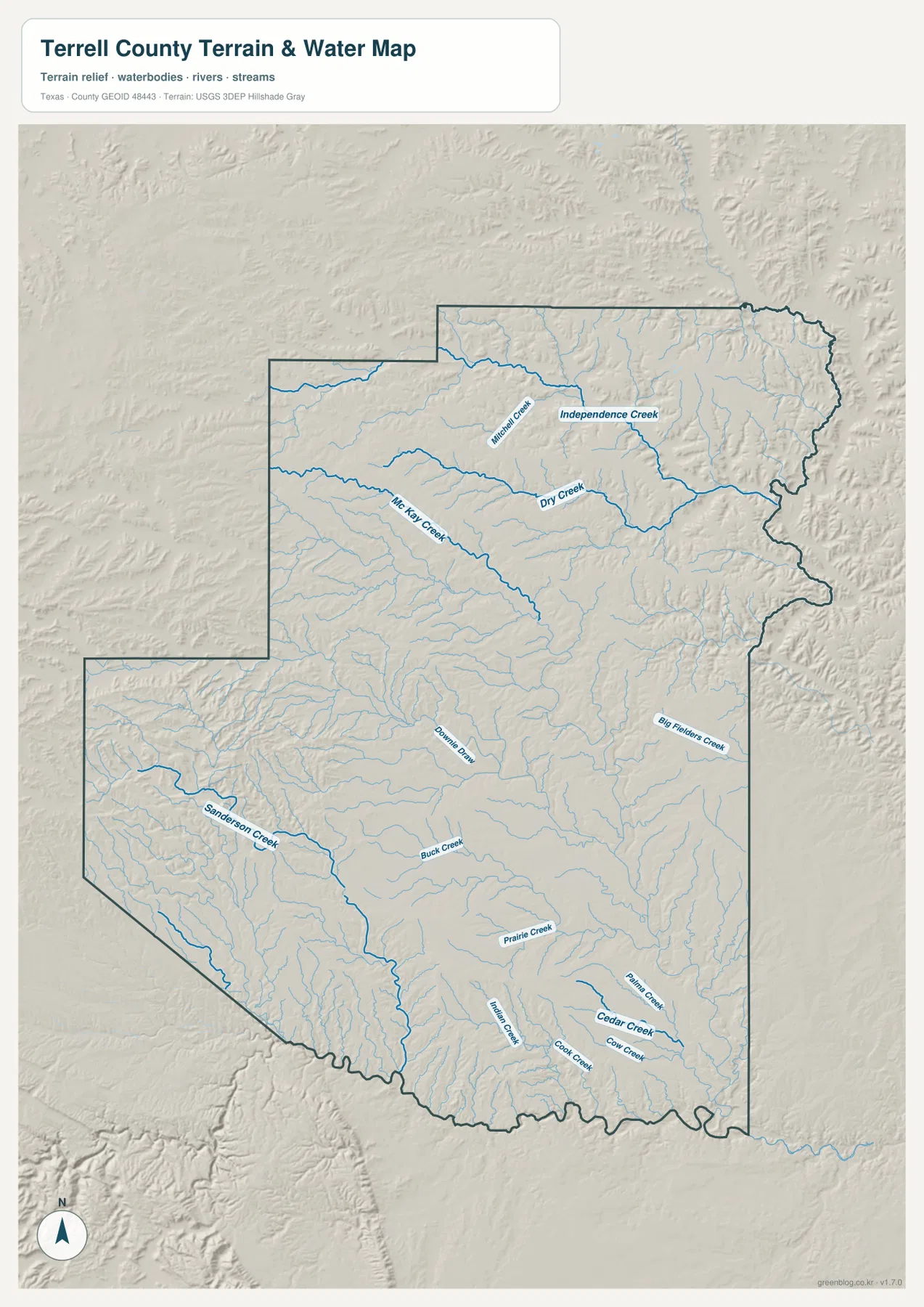
Terrell County’s water layer is dominated by creeks and draws rather than large lakes. A practical reading method is to separate the northern Independence Creek area from the Sanderson Creek valley in the southwest and the Cedar Creek group in the southeast, then place the smaller tributaries between them. This map is intended for geographic water and terrain reference, not flood-hazard analysis, parcel boundaries, navigation, or border-management decisions.
The elevation range spans nearly 800 meters
The elevation map reports an actual range of about 359 to 1,137 meters and a mean elevation of 724 meters. The darkest brown high ground occupies much of the west and southwest, with additional high ridges across the northwestern interior. Those uplands are deeply dissected and look more like a broken mountain-and-canyon surface than a uniform plateau.
Moving east, the colors shift through tan and yellow into broad green lowlands. The southern interior also contains extensive lower terrain, while narrow green valleys cut back into the higher western blocks. The northeast is complex: low corridors descend along the county edge, but lighter ridges remain between them. This is not a simple one-direction slope; multiple high blocks and drainage valleys create a strongly broken relief pattern.
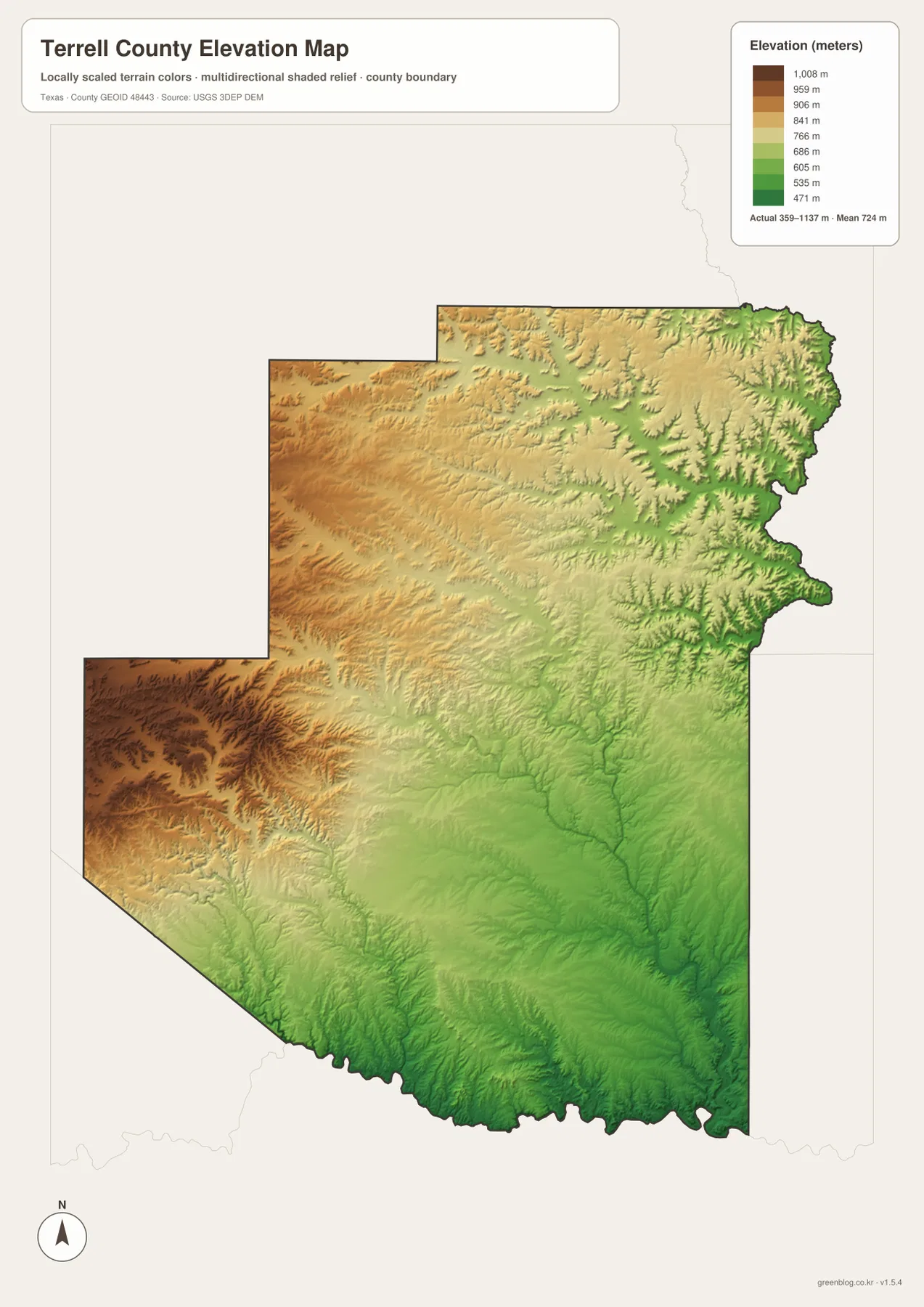
Comparing the relief map with the water layer makes the creek network much easier to understand. Sanderson Creek and the southern tributaries occupy lower corridors, while Independence Creek and Dry Creek also follow valleys cut into higher uplands. This countywide elevation surface is intended for broad terrain comparison rather than parcel surveying, road engineering, or construction design. Exact site elevation should be checked with detailed source data or a local survey.
Choose the map by whether roads, desert drainage, or relief matters most
Use the county reference map when Sanderson, U.S. 90, U.S. 285, route 349, smaller place labels, and the county boundary need to appear together. The terrain-and-water map is the better choice for tracing Independence Creek, Sanderson Creek, Prairie Creek, and the southeastern tributaries. The elevation map is the clearest view for comparing the very high western uplands with the lower southern and eastern valleys.
The download package contains three separate high-resolution A3 JPG files for Terrell County: county reference, terrain and water, and elevation. You can inspect the lighter WebP versions in the article first and then use the larger JPG files for printing, classroom material, presentations, or an editable local-reference document.
Frequently Asked Questions
Which direction does U.S. 285 run from Sanderson?
On the supplied county map, U.S. 285 extends north from the Sanderson area. U.S. 90 provides the main east-west reference through Sanderson, so the two roads are useful for orienting the southwestern part of the county.
Where is the highest terrain in Terrell County?
The elevation map places the strongest high-elevation colors in the west and southwest. The southern and eastern creek valleys are much lower. The actual mapped countywide range is about 359 to 1,137 meters.
Does the Terrell County download include a city map?
No. The current package includes only the county-reference, terrain-and-water, and elevation maps, and the downloadable A3 JPG ZIP contains those same three map types.
Map File Information
The ZIP contains the three Terrell County maps in high-resolution A3 JPG format.
- Included Versions: County reference, terrain and water, elevation
- Included Files: 3 A3 JPG maps
Related Maps
Sources and data references
Roads and the Terrell County boundary around Sanderson can be cross-checked with the U.S. Census Bureau TIGER/Line Shapefiles. Independence Creek, Sanderson Creek, Cedar Creek, and other named drainage features can be checked against USGS National Hydrography, while terrain height data are available through the USGS 3D Elevation Program. Place labels, route numbers, water names, and the 359–1,137 meter elevation range described above are based on the Terrell County maps and existing article material supplied in this package.
Green Map creates custom-edited map images using open geographic data sources such as geoBoundaries, Natural Earth, OpenStreetMap, and government open data.
These maps are edited visual materials, not raw data files, and are provided for education, documents, presentations, and graphic reference.