You can download the Perry County Tennessee Map files on this page as one ZIP containing high-resolution JPG versions of the county, city, water, and elevation views for A3 printing, presentations, classroom work, or local reference. The Tennessee River follows the western edge of the county, while the Buffalo River winds north to south through the interior. Linden sits near the county’s main road junction in the south-central area, and Lobelville provides a second reference farther north, making the two river systems and two town centers the clearest starting points for understanding the county.
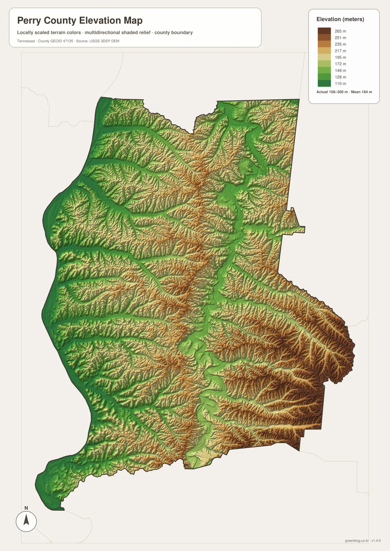
Perry County changes character quickly from west to east. Low ground follows the Tennessee River and several west-flowing creek valleys, while higher ridges become more prominent toward the east and southeast. The Buffalo River creates a second low corridor through the middle of the county, so the landscape is not a simple slope away from one river; it is a series of ridges and valleys between two major drainage systems.
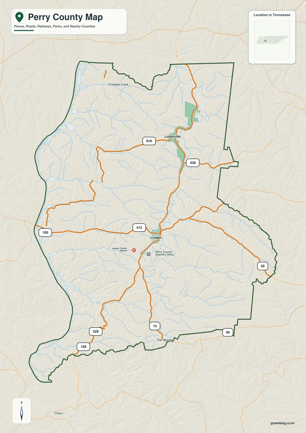
Table of Contents
Linden and Lobelville give the county two different orientation points
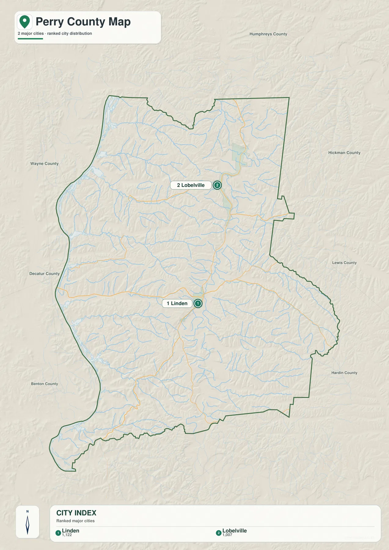
The ranked city map shows only two major cities: Linden in first place and Lobelville in second. The map labels them at 1,122 and 1,007 residents respectively, so neither overwhelms the other by size. Their geographic roles are more important than the population difference. Linden is the county seat and lies near the junction of US 412 and SR 13, while Lobelville sits farther north near the Buffalo River corridor.
Several labels around Linden reinforce its role as the administrative and transportation reference. The Perry County Sheriff’s Office and James Tucker Airport appear nearby, and roads spread from the area toward both the Tennessee River side and the eastern hills. Lobelville has a different setting: routes curve close to the Buffalo River, and the town is a better starting point for understanding the northern half of the county.
The neighboring counties help explain why these two places feel separated. Humphreys County lies to the north, Hickman and Lewis counties are east of Perry County, and Hardin County is toward the southeast. The Tennessee River side faces Decatur, Benton, and Wayne counties across or near the western and southwestern boundary. Beginning with Linden and Lobelville and then adding those edge directions gives a much clearer picture than memorizing a list of county names.
US 412 and SR 13 provide the simplest way to follow the road network
US 412 is the most obvious east-west route on the county map. It crosses the western side toward the Tennessee River, passes through Linden, and continues across the higher country toward the east. SR 13 gives the county a strong north-south connection through the Linden area and toward Lobelville. Once those two roads are located, the smaller state routes make more sense because they branch toward different river valleys and county edges.
SR 100 follows the lower western side near the Tennessee River, while SR 128 serves the southwestern extension. SR 48 appears near the southern edge, and SR 20 reaches the eastern side through more rugged terrain. Roads near Lobelville bend with the Buffalo River valley, while several roads in the southeast turn around ridges rather than crossing them in long straight lines.
For a practical reading sequence, start at the US 412–SR 13 area in Linden, follow SR 13 toward Lobelville, and then compare the western river routes with the eastern hill routes. This makes the county’s transportation layout visible without turning the page into a highway-number inventory. The static map is not a live traffic product, so current closures, construction, or bridge restrictions should be checked with TDOT before travel.
The Tennessee and Buffalo rivers organize most of the drainage
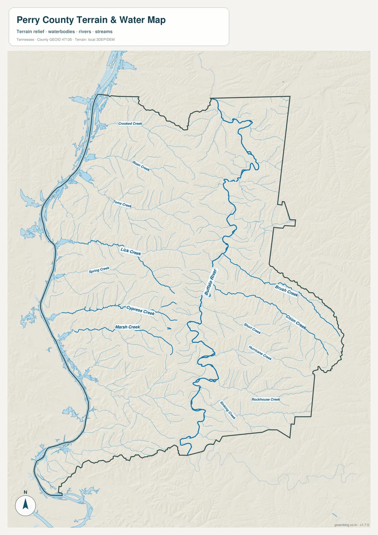
The water map is dominated by the Tennessee River on the western boundary and the Buffalo River in the interior. The Tennessee is broad and closely follows the county’s west side, while the Buffalo enters the northeastern part of the county and winds southward through a long central valley. Many smaller creeks occupy the space between them or drain east of the Buffalo into separate valleys.
Crooked Creek is the northernmost named west-flowing stream on the map. Roan Creek and Toms Creek occupy separate valleys farther south, while Lick Creek creates a longer connection between the interior and the Tennessee River side. Spring Creek, Cypress Creek, and Marsh Creek continue the same pattern across the western half, giving the river lowlands a series of distinct feeder valleys rather than one broad flat plain.
East of the Buffalo River, Brush Creek and Coon Creek reach into the southeastern hills, joined by shorter valleys such as Short Creek, Hurricane Creek, Rockhouse Creek, and Shaw Creek. A useful way to read this network is to treat the Buffalo River as a central divider: western tributaries generally open toward the Tennessee River lowlands, while the eastern creeks cut into higher ridge country. That relationship becomes even clearer on the elevation sheet.
Elevation ranges from about 108 to 300 meters
The supplied elevation map lists an actual range of about 108 to 300 meters, with a mean near 184 meters. The lowest green terrain follows the Tennessee River along the western edge and also appears in the Buffalo River valley through the center. Higher yellow and brown ridges fill much of the land between those low corridors and become especially strong toward the east and southeast.
The southeastern hills are the most visually rugged part of the map. Brush Creek, Coon Creek, Rockhouse Creek, and nearby tributaries cut narrow green lines between dense ridges. Western Perry County looks gentler because the Tennessee River floodplain and lower creek valleys occupy broader areas. This difference helps explain why road alignments in the east bend more frequently than routes near the river.
The north is also dissected by creek valleys rather than uniformly flat. Crooked Creek and Roan Creek carve lower routes toward the Tennessee River, with higher ridges between them. A better summary of Perry County relief is therefore “two major low corridors separated and surrounded by ridges” rather than a simple west-low/east-high pattern.
County facts that add context to the maps
- Official name: Perry County, Tennessee
- County seat: Linden
- FIPS code: 47135
- 2020 Census population: 8,366
- July 2025 population estimate: 9,126
- Gazetteer land area: about 414.8 square miles
- Elevation shown on this map: about 108–300 m, mean about 184 m
The 2020 Census count and the July 2025 estimate are different types of statistics and should remain labeled separately. The newer estimate is higher than the completed Census count, but it does not identify which town, road corridor, or valley accounts for the change. The city map likewise does not imply that the entire county population is concentrated in Linden and Lobelville; rural settlements and homes are spread across a much larger area.
The Gazetteer land area of about 414.8 square miles covers river lowlands, ridge country, roads, farms, and rural settlement. A countywide population density therefore describes scale, not the exact concentration of residents in each valley. The maps are most useful when these county totals are paired with the visible settlement and terrain pattern.
Tennessee State Library and Archives material provides historical county context and confirms Linden as the county seat. On the modern map, that administrative role aligns with a practical transportation center where US 412 and SR 13 meet. The historic and present-day references therefore point to the same place for different reasons.
Choose the map according to the question
The county reference map works best when the boundary, Linden, Lobelville, roads, and selected local labels need to appear together. The city sheet is cleaner for a quick comparison of the two ranked towns and their position relative to neighboring counties. These two maps are usually the best starting point for a general county overview.
Use the water map when the relationship between the Tennessee River, Buffalo River, and named creeks is more important than roads. Use the elevation map when the question is why eastern routes curve, why some streams occupy narrow valleys, or how the broad western lowlands differ from the ridge country. Viewing the water and elevation sheets together provides the clearest explanation of the county’s terrain.
The download ZIP contains high-resolution JPG versions of all four maps and is designed for A3 output. Keep the original proportions when printing, and use a copy for arrows or annotations if you need to mark routes or teaching notes. These are static reference maps rather than live sources for road closures, flood warnings, legal parcel boundaries, or current river levels.
Frequently Asked Questions
How are Linden and Lobelville different on the Perry County Tennessee Map?
Linden is the county seat in the south-central part of Perry County near US 412 and SR 13. Lobelville is farther north near the Buffalo River corridor. Using both towns as reference points makes it easier to separate the southern road network from the northern river valley.
What is the difference between the Tennessee River and Buffalo River on the map?
The Tennessee River follows the western county boundary as a broad waterway. The Buffalo River runs through the interior from north to south. Many western tributaries drain toward the Tennessee River lowlands, while eastern tributaries cut into higher ridges beside the Buffalo River.
What does the elevation map show most clearly?
It shows low ground along the Tennessee and Buffalo river valleys and higher ridges toward the east and southeast. The displayed elevation range is about 108 to 300 meters, with a mean near 184 meters.
Map File Information
The ZIP contains high-resolution JPG versions of the county, city, water, and elevation maps. They are suitable for A3 printing, presentations, classroom material, and general location reference.
- Included Files: county, city, water, and elevation JPGs
- File Type: JPG files in one ZIP
Related Maps
- White County Tennessee map | Sparta and Calfkiller River
- Alamo to Gadsden: A Crockett County Tennessee Map
- Altamont, Monteagle, and Plateau Valleys — Grundy County Tennessee Map
Sources and references
- Tennessee State Library and Archives — Perry County fact sheet
- Tennessee Department of Transportation — Perry County road reference
- U.S. Census Bureau QuickFacts — Perry County, Tennessee
- U.S. Census Bureau TIGER/Line boundary data
- USGS National Hydrography
- USGS 3D Elevation Program
Green Map creates custom-edited map images using open geographic data sources such as geoBoundaries, Natural Earth, OpenStreetMap, and government open data. These maps are edited visual materials, not raw data files, and are provided for education, documents, presentations, and graphic reference.