The Overton County map on this page is easiest to understand by starting with Livingston and then looking outward toward the river valleys and higher ground that divide the county. Livingston is the main urban reference, while Hilham, Timothy, and Muddy Pond mark very different directions inside the boundary. Four high-resolution JPG map files can be downloaded together as one ZIP for A3 printing, classroom work, presentations, or general county reference.
The county is not topographically uniform. Lower country spreads across much of the west and northwest, while ridges rise sharply through the eastern and southeastern sections. The road, water, and elevation maps show the same landscape from different angles: highways converge near Livingston, streams occupy narrow valleys, and the strongest relief appears farther east.
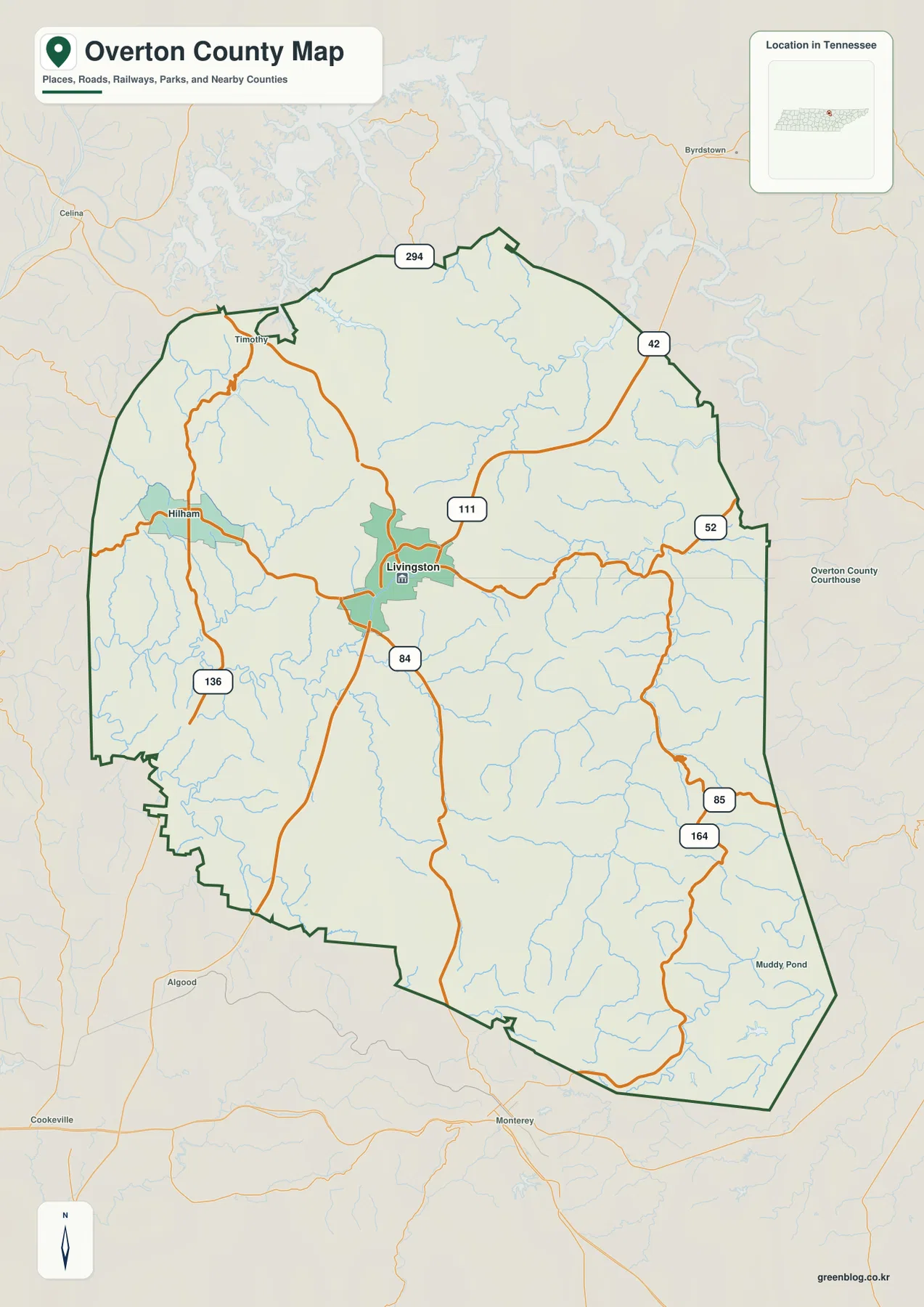
Table of Contents
Livingston sits where the county’s main road directions separate
Livingston is slightly north of the county’s central area and serves as the clearest road reference. SR 111 runs through the county in a strong north-south direction, SR 52 heads east from the Livingston area, and SR 84 continues south. SR 136 reaches toward Hilham in the west, while SR 294 crosses the northern portion. Farther east, SR 42 and the SR 85–164 routes provide separate approaches through more rugged terrain.
The road shapes are important because they reflect the terrain. West of Livingston, several routes cross comparatively gentle country, but farther east the roads bend more often as they follow stream valleys or skirt higher ridges. The southeastern routes are especially useful when the road map is compared with the elevation sheet, where narrow green valleys cut between broad areas of higher brown relief.
Hilham gives a good western reference, Timothy helps locate the northwestern edge, and Muddy Pond marks the southeastern side. These places are more useful when described relative to Livingston than when treated as an isolated list. Together they show how the county stretches from a lower western half into a more strongly dissected eastern landscape.
The city map emphasizes one clear center: Livingston
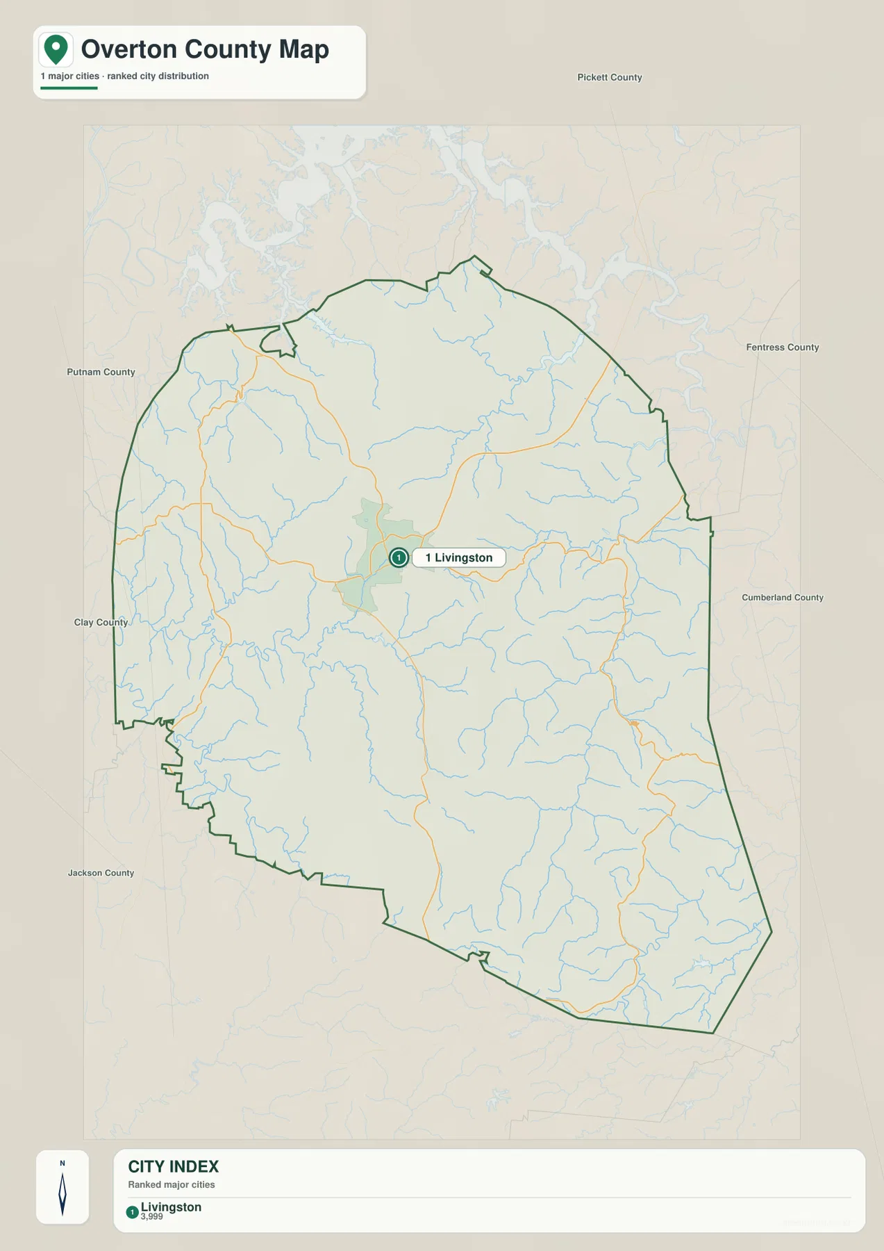
The ranked city sheet identifies Livingston as the only major city and labels its population as 3,999. That makes the map different from a county with several similarly sized towns. Rather than comparing multiple urban centers, the useful question here is how Livingston connects to the county’s outer roads, valleys, and neighboring jurisdictions.
Pickett County is shown north of Overton County, Fentress County lies to the east and northeast, and Cumberland County is toward the southeast. Jackson County borders the southwest, Clay County is to the west, and Putnam County appears on the west-northwestern side. Livingston is not pressed against one county line; it sits well inside the outline, which reinforces its role as the practical center for county orientation.
Roaring River and the Obey River forks divide the terrain into separate valleys
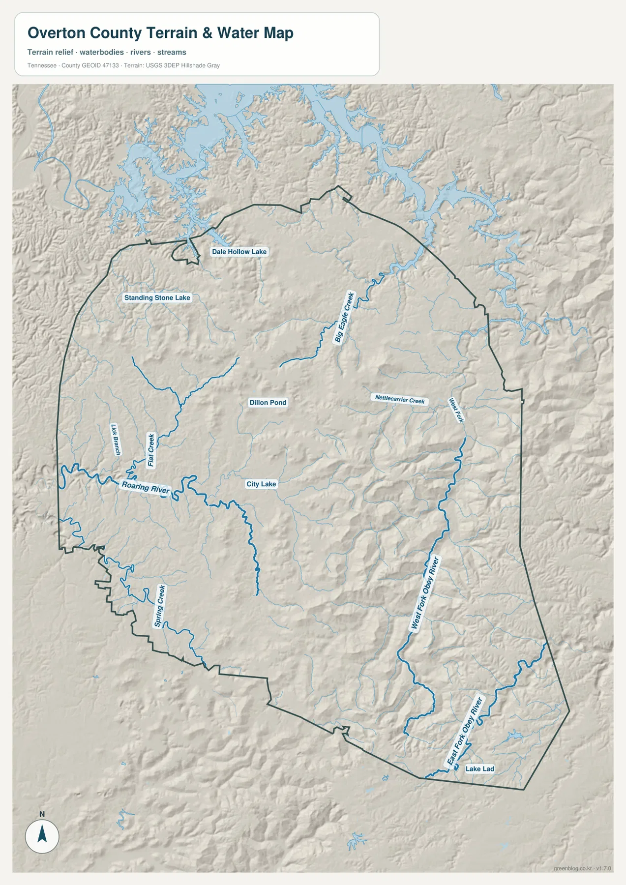
Roaring River is one of the easiest water features to follow on the western side. It enters near the county edge, bends across the lower terrain southwest of Livingston, and receives shorter tributaries such as Lick Branch and Flat Creek. City Lake and Dillon Pond provide smaller water references near the central part of the county, where the terrain is less severe than the high ridges farther east.
The eastern half is organized by a different drainage pattern. West Fork Obey River extends through the southeast and northward along a long valley, while East Fork Obey River follows a separate channel near the southern edge. Big Eagle Creek is prominent in the northeast, and Miller Creek and Nettlecarrier Creek occupy additional valleys between the ridges. The streams do not form a simple parallel network; they twist between higher ground and make the eastern side look much more deeply cut than the west.
Dale Hollow Lake is visible near the northern boundary and works as a strong regional landmark even though most of the large reservoir lies outside the county outline. Standing Stone Lake is shown farther west, while Spring Creek and Lake Lad help identify the southern section. The water map is intended for locating waterways and comparing terrain, not for flood-risk decisions, navigation, or current water-level conditions.
Elevation rises from about 176 meters to more than 600 meters
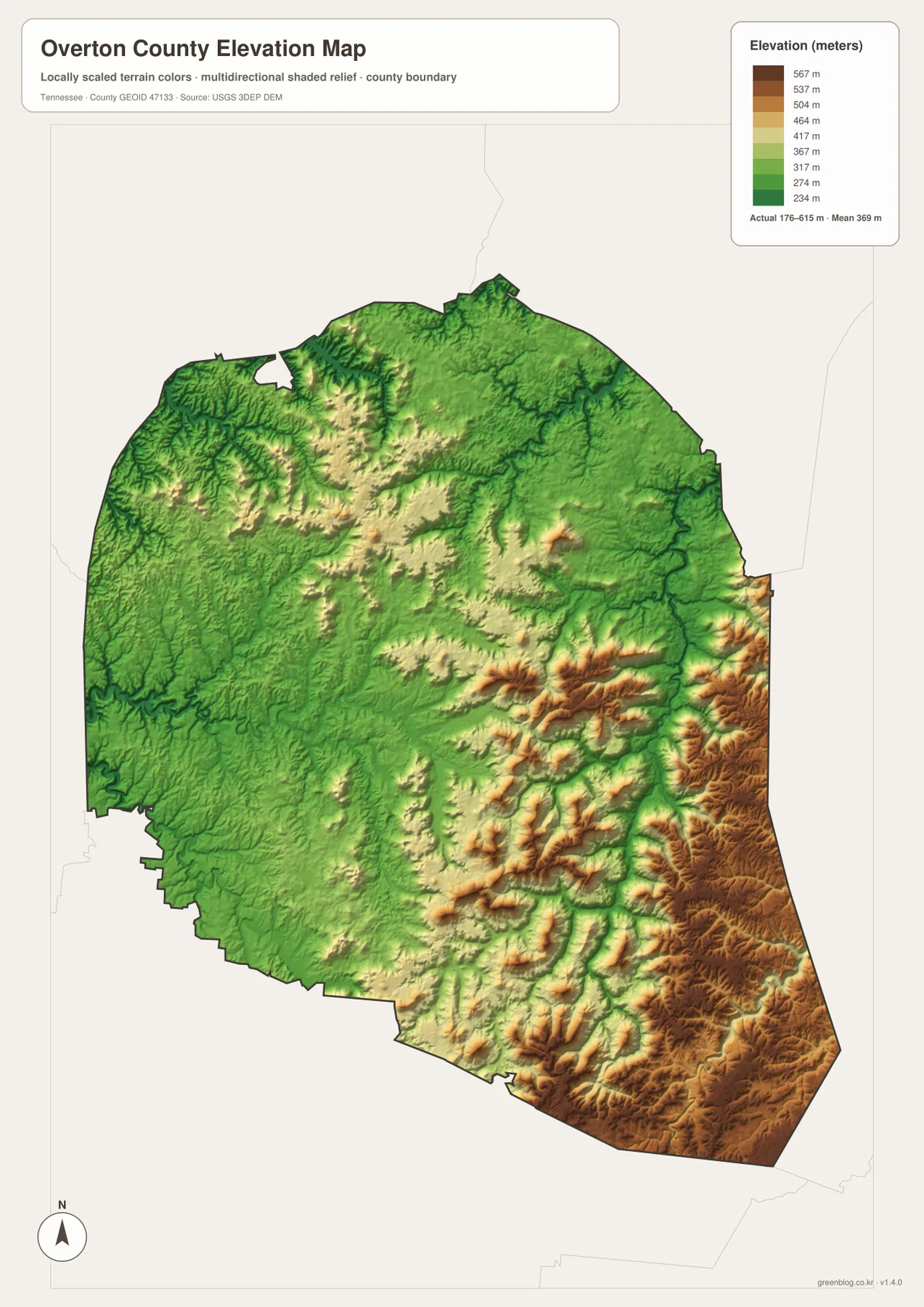
The supplied elevation map lists an actual range of about 176 to 615 meters, with a mean near 369 meters. Large areas of the west and northwest are green, indicating lower terrain, while yellow, tan, and brown ridges become increasingly common toward the center-east and southeast. The strongest high-relief area occupies the eastern and southeastern edge.
Roaring River cuts through lower ground on the western side, but the Obey River forks occupy narrow valleys surrounded by much higher ridges. This contrast explains why the eastern drainage looks confined and why roads there tend to curve more often. The map is especially useful for comparing the broad western lowlands with the series of steep ridges that continue toward the Cumberland Plateau side of the county.
Livingston sits in terrain that is generally lower and less rugged than the highest eastern ridges. That difference matters for map reading because a short straight-line distance can cross several ridges and valleys. The elevation sheet is a generalized county reference rather than survey-grade data, so it should be used to compare relative relief, not to determine an exact engineering elevation at a specific property.
County facts that add context to the maps
- Official name: Overton County, Tennessee
- County seat: Livingston
- FIPS code: 47133
- 2020 Census population: 22,511
- July 2025 population estimate: 23,787
- Area: 433.5 square miles of land and 1.3 square miles of water
- Elevation shown on this map: about 176–615 m, mean about 369 m
The population and area figures above are carried in the supplied Census-based source material. The 2025 value is an estimate and should remain distinct from the completed 2020 Census count. Countywide totals also cover very different settings, from Livingston to rural valleys and high ridges, so they should not be read as a description of how every part of Overton County is populated.
Tennessee State Library and Archives material identifies Overton County as having been established in 1806 and Livingston as the county seat. On the modern map, that historical administrative center also lines up with the main road network. The combination of old county organization and present-day transportation makes Livingston a practical starting point for nearly every map on this page.
Which map works best for the question you have?
Use the county reference map when you need the boundary, Livingston, outer place names, and major routes on one sheet. It is the best choice for a general county overview or a presentation where road direction matters. The city map is cleaner when the goal is to show Livingston’s position inside the county and compare it with the neighboring county directions.
The water map is more useful for following Roaring River, the Obey River forks, Big Eagle Creek, and Dale Hollow Lake without the road network dominating the page. When relief matters, the elevation map immediately separates the lower western half from the much higher eastern ridges. Viewing the water and elevation sheets together gives the clearest explanation of why streams occupy narrow valleys and why some routes bend around higher ground.
The download ZIP contains high-resolution JPG versions of all four maps and is designed for A3 output. Keep the original proportions when printing, and work on a copy if you plan to add arrows, labels, or route notes. Static maps are not substitutes for current road closures, legal parcel boundaries, flood warnings, or live water conditions, so those questions should be checked with the appropriate agency.
Frequently Asked Questions
Where is Livingston on the Overton County Map?
Livingston is slightly north of the county’s central area and is the point where several major routes converge. SR 111 runs through the area, while SR 52 and SR 84 provide important east-west and southbound connections. The city map ranks Livingston as the county’s single major city.
How does Dale Hollow Lake relate to Overton County?
Most of the large Dale Hollow Lake reservoir is outside the county, but parts of its branching water surface are visible close to the northern boundary. It is a useful north-side landmark when comparing the county with Big Eagle Creek and the Obey River valleys farther south.
What is the strongest elevation contrast on the map?
The biggest contrast is between the lower west and northwest and the high ridges that dominate the east and southeast. The displayed elevation range is about 176 to 615 meters, with a mean near 369 meters. Narrow Obey River valleys cut through the higher terrain.
Map File Information
The ZIP contains high-resolution JPG versions of the county, city, water, and elevation maps. They are suitable for A3 printing, presentations, classroom material, and general location reference.
- Included Files: county, city, water, and elevation JPGs
- File Type: JPG files in one ZIP
Related Maps
- Alamo to Gadsden: A Crockett County Tennessee Map
- Altamont, Monteagle, and Plateau Valleys — Grundy County Tennessee Map
- Around Chattanooga: Hamilton County Tennessee Map
Sources and references
- Tennessee State Library and Archives — Overton County fact sheet
- Tennessee Department of Transportation — Overton County road reference
- U.S. Census Bureau QuickFacts — Overton County, Tennessee
- U.S. Census Bureau TIGER/Line boundary data
- USGS National Hydrography
- USGS 3D Elevation Program
Green Map creates custom-edited map images using open geographic data sources such as geoBoundaries, Natural Earth, OpenStreetMap, and government open data. These maps are edited visual materials, not raw data files, and are provided for education, documents, presentations, and graphic reference.