This Obion County map is organized around Union City and the low river country of northwestern Tennessee. The county view places Union City beside the main road network, the city sheet compares it with South Fulton, Troy, Obion, Woodland Mills, and Hornbeak, and the water and elevation sheets show why the western lowland looks so different from the rolling interior. You can download the matching high-resolution JPG files as one ZIP for A3 printing, classroom use, presentations, and general county reference.
Union City is the most useful starting point because it sits in the northern half of the county where several routes meet. South Fulton is farther northeast near the Kentucky line, Troy lies to the southwest, Obion is south of Union City, Woodland Mills is north, and Hornbeak is toward the western side. Once those places are located, the county’s long east-west shape, the Reelfoot Creek lowland, and the separate forks of the Obion River become much easier to follow.
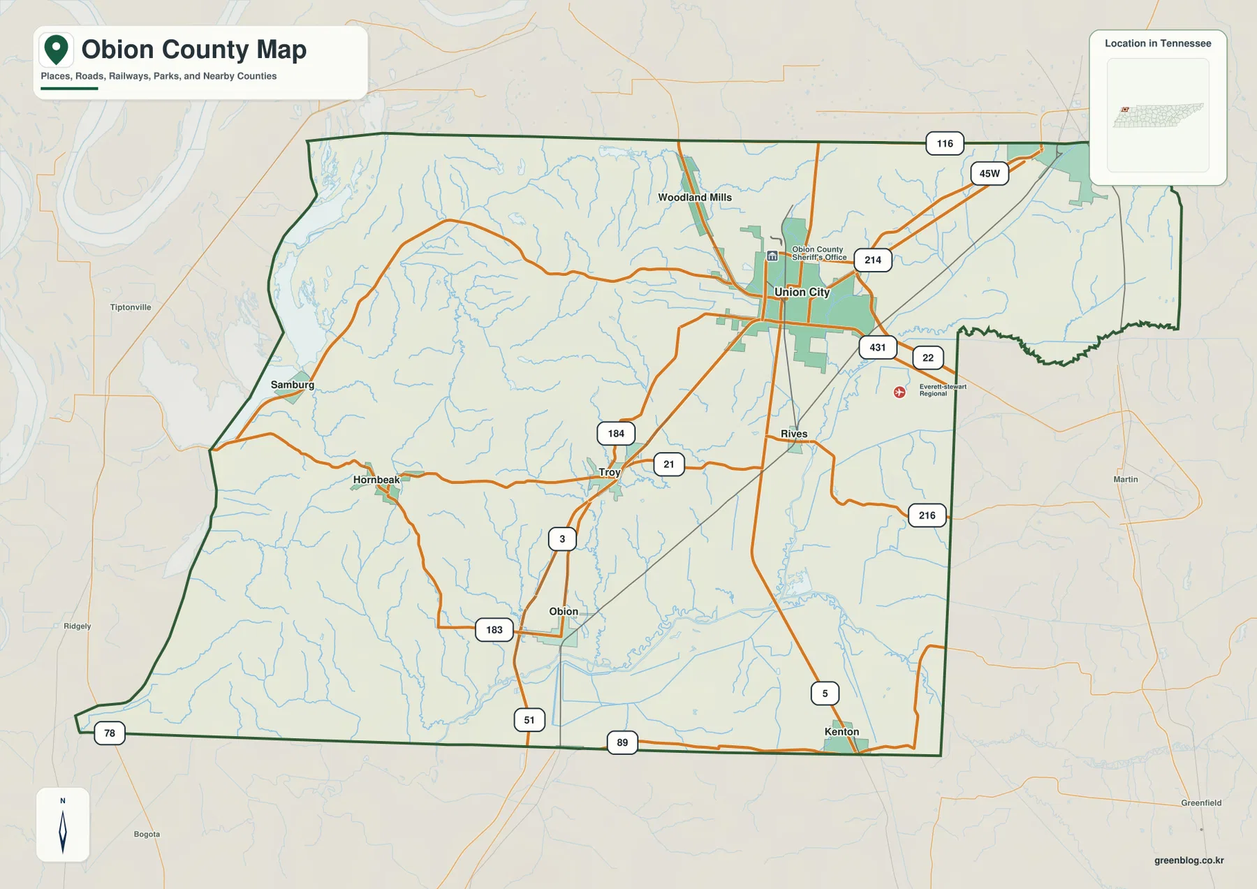
Table of Contents
Union City makes the city pattern easy to understand
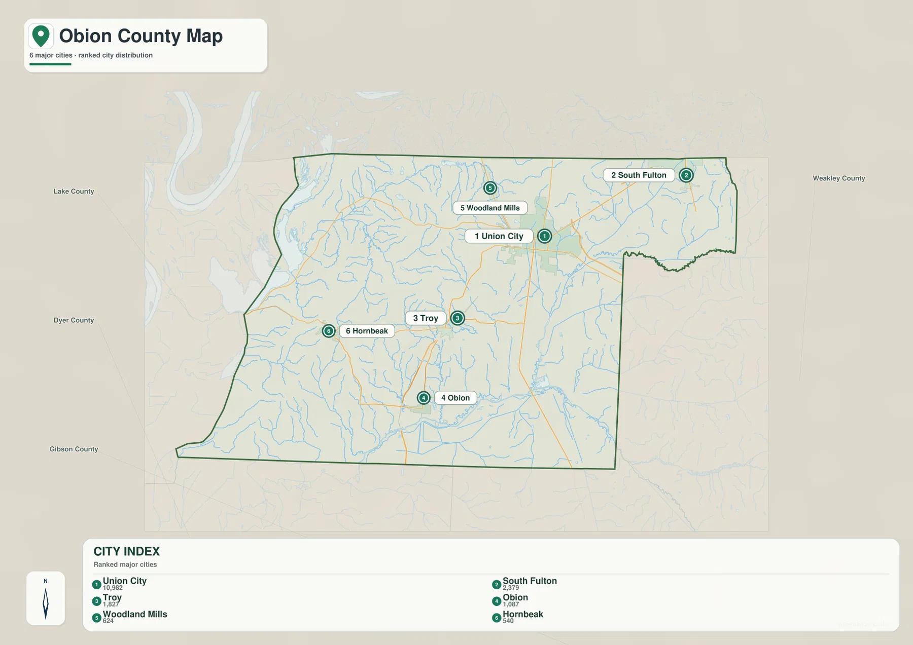
The city sheet ranks Union City first and places it near the center of the county’s northern half. South Fulton sits close to the northeastern edge and the Kentucky state line, while Troy is southwest of Union City and Obion is farther south. Woodland Mills provides a northern reference and Hornbeak marks the western side. These locations show that settlement is not arranged in a simple ring around one center; instead, the towns follow several different road and terrain corridors.
The city index printed on the map lists Union City at 10,982, South Fulton at 2,379, Troy at 1,827, Obion at 1,087, Woodland Mills at 624, and Hornbeak at 540. Those are the values shown on the supplied city graphic, not a separate claim about a new population estimate. Their main value on this page is to explain the ranking and to show how strongly Union City stands out from the smaller places around it.
The reference map adds other place names such as Rives and Samburg, which are useful when the ranked city list is not enough. Lake County and Dyer County lie to the west, Gibson County is to the south, and Weakley County is to the east. The northern boundary reaches Kentucky, where Fulton County and Hickman County continue beyond the Tennessee line. South Fulton is especially useful for understanding that northern edge.
Roads spread from Union City across a long, irregular county
Obion County stretches a considerable distance from west to east, and the eastern side contains a deep inward notch that breaks up the outline. From Union City, routes fan northeast toward South Fulton, southwest toward Troy and Hornbeak, and south toward Obion and Kenton. The reference sheet labels route numbers including 45W, 51, 21, 22, 184, 214, and 216, giving enough information to trace the major county-scale connections without turning the page into a street map.
The southern route from Union City passes the Rives area before continuing toward Obion and the southeastern edge. To the west, the network crosses rolling ground toward Troy and Hornbeak. The northeastern approach climbs toward South Fulton and the state line. The map becomes more informative when these roads are compared with the elevation sheet, because the western low ground, central ridges, and eastern stream valleys help explain why the connections do not form a perfectly even grid.
Places near the county line are also useful as orientation points. Samburg sits near the western side in the direction of Lake County, while Kenton is marked close to the southeastern edge. South Fulton almost touches the northern state boundary. Instead of memorizing every place label, it is easier to use Union City as the hub and divide the county into the northeastern, western, and southern approaches.
The Obion River forks and Reelfoot creeks divide the drainage
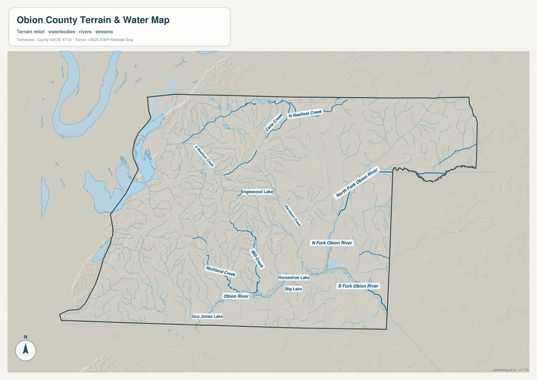
The water map is dominated by two different systems. In the eastern and southern half, North Fork Obion River, Middle Fork Obion River, and South Fork Obion River occupy separate low corridors. The Obion River itself is labeled farther south, where Richland Creek and Hill Creek add smaller tributary valleys. These channels make the southeastern half look broad and flat compared with the more broken terrain toward the interior.
The northwestern side is organized around the Reelfoot drainage. North Reelfoot Creek runs near the northern edge, Cane Creek joins the same general lowland, and South Reelfoot Creek crosses the western side. On the elevation sheet, this part of the county is shown in some of the darkest green tones, confirming that the creek system occupies a particularly low section of the landscape.
Several lakes provide additional local references. Englewood Lake is shown west of the central area, Horseshoe Lake and Big Lake sit farther south, and Guy Jones Lake appears close to the southern boundary. These are not presented as one continuous lake district; instead, they show how many separate low basins and stream valleys are scattered across the county. Viewing the water and elevation maps side by side makes their setting much clearer.
Elevation runs from about 80 to 171 meters
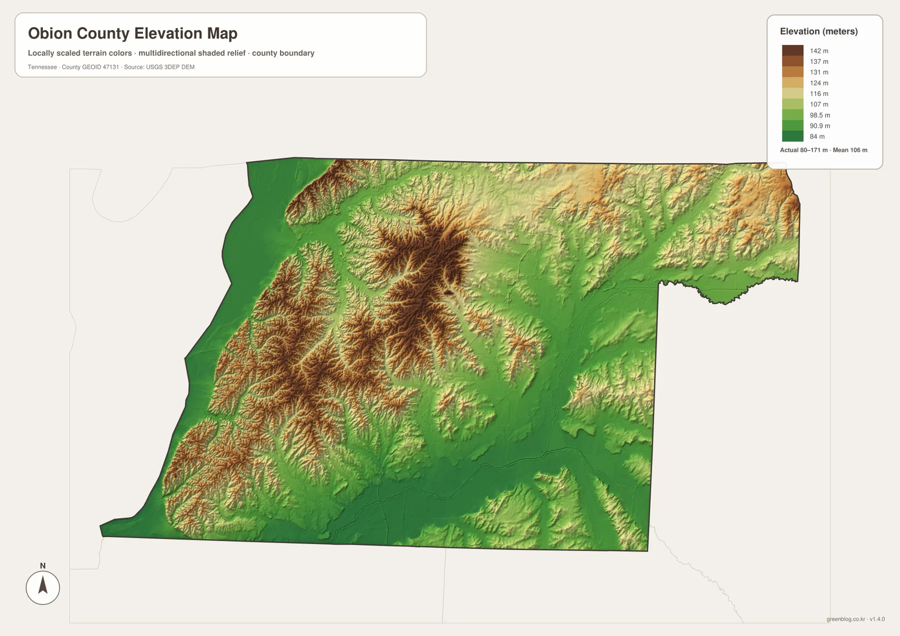
The supplied elevation sheet lists an actual range of about 80 to 171 meters and a mean of about 106 meters. That is a modest countywide range compared with mountainous eastern Tennessee, yet the local contrast is easy to see. Dark green marks the lowest ground, while tan and brown highlight ridges and higher rolling terrain.
The western edge and the broad southeastern stream corridors contain large areas of low green relief. The Reelfoot Creek system occupies the northwestern lowland, and the Obion River forks follow other low corridors toward the east and south. In contrast, the west-central interior contains clusters of stronger brown relief, with narrow stream valleys cutting through higher ground between Troy, Hornbeak, and the central part of the county.
The northeast is not as flat as the western lowland, but its relief is generally gentler than the strongest ridges in the west-central area. Union City itself lies in a landscape where small differences in height are mixed with shallow drainage corridors. For that reason, the elevation map is most useful as a comparison between the Reelfoot lowland, the interior ridges, and the Obion River valleys rather than as a search for one isolated high point.
County facts that support the map
- Official name: Obion County, Tennessee
- County seat: Union City
- FIPS code: 47131
- 2020 Census population: 30,787
- July 2025 population estimate: 30,067
- Gazetteer area: 544.9 square miles of land and 10.6 square miles of water
- Elevation shown on this map: about 80–171 m, mean about 106 m
The population and area figures above are the Census values already included in the supplied county package, while the elevation range is printed directly on the provided elevation graphic. The 2020 census count and the 2025 estimate refer to different dates and should remain separate. For map reading, the more useful geographic question is where Union City and the smaller towns sit in relation to the roads, low stream corridors, and county boundary.
The package also identifies Obion County as a county established in 1823 with Union City as its current county seat. That background helps explain why Union City is the administrative reference on the page. There is no need to turn the map article into a long county history; the information is most useful as context for why Union City should be located first before the surrounding towns and terrain are compared.
Which map should you use?
The county reference sheet is the best starting point when you need Union City, roads, county boundaries, and surrounding places on one page. It works well for presentation slides, school work, and general location explanations because South Fulton, Troy, Obion, Hornbeak, and edge communities can be compared at the same scale. The city sheet is cleaner when the main goal is to show the ranked towns and their relative positions.
Use the water map when the Obion River forks, Reelfoot Creek, or the smaller lakes are the main subject. It removes much of the road detail and makes the drainage corridors easier to trace. Choose the elevation sheet when the difference between the western lowland and the interior rolling terrain matters. The water and elevation sheets work especially well together because the larger streams line up with many of the lowest corridors.
The downloadable ZIP contains high-resolution JPGs suitable for A3 printing. Keep the original aspect ratio when printing, and add route arrows or notes on a copy rather than altering the clean master file. These are static county reference maps, so current road closures, flood warnings, property boundaries, and legal land records should be checked with the responsible agency before they are used for travel or legal decisions.
Frequently Asked Questions
Where is Union City on the Obion County Map?
Union City is in the northern half of the county near the center of the main road network. South Fulton is northeast near the Kentucky line, Troy is southwest, and Obion is farther south. The city map ranks Union City first, making it the easiest place to use as the starting point for directions.
Where are the main Obion River channels shown?
North Fork Obion River is labeled in the eastern part of the county, Middle Fork Obion River lies farther south and toward the center, and South Fork Obion River runs across the southeast. The Obion River itself is labeled in the southern section, with smaller tributaries including Richland Creek and Hill Creek nearby.
What stands out on the elevation map?
The clearest contrast is between the very low western Reelfoot Creek area and the higher rolling ground in the west-central interior. The map shows an actual range of about 80 to 171 meters and a mean near 106 meters. Low corridors also follow the Obion River forks in the eastern and southern parts of the county.
Map File Information
The ZIP contains high-resolution JPG versions of the county, city, water, and elevation maps. They can be used for A3 printing, presentations, classroom material, and general location reference.
- Included Files: four JPG map files
- File Type: JPG files in one ZIP
Related Maps
- Alamo to Gadsden: A Crockett County Tennessee Map
- Altamont, Monteagle, and Plateau Valleys — Grundy County Tennessee Map
- Around Chattanooga: Hamilton County Tennessee Map
Sources and references
- Tennessee State Library and Archives — Obion County fact sheet
- Tennessee Department of Transportation — Obion County road reference
- U.S. Census Bureau QuickFacts — Obion County
- U.S. Census Bureau TIGER/Line boundary data
- USGS National Hydrography
- USGS 3D Elevation Program
Green Map creates custom-edited map images using open geographic data sources such as geoBoundaries, Natural Earth, OpenStreetMap, and government open data. These maps are edited visual materials, not raw data files, and are provided for education, documents, presentations, and graphic reference.