Wartburg provides the clearest starting point for Morgan County, but the county makes more sense once the rivers and steep eastern ridges are added to the picture. The maps on this page place Sunbright north of Wartburg, Oakdale to the south, and Petros and Coalfield toward the eastern side, while the water and elevation sheets show why those places are separated by a complicated network of valleys. The same four maps are available as high-resolution JPG files in one downloadable ZIP for A3 printing, classroom work, presentations, and map annotation.
Morgan County is not a flat plateau with a few towns scattered across it. The western half is broad and rolling, the eastern side contains tightly packed ridges, and major streams cut between them. Route 62 passes through Wartburg, Obed River bends across the south-central part of the county, and the Emory River system drains a large share of the center and east. Reading those features together gives a much better explanation of the county than a generic description of the Cumberland Plateau.
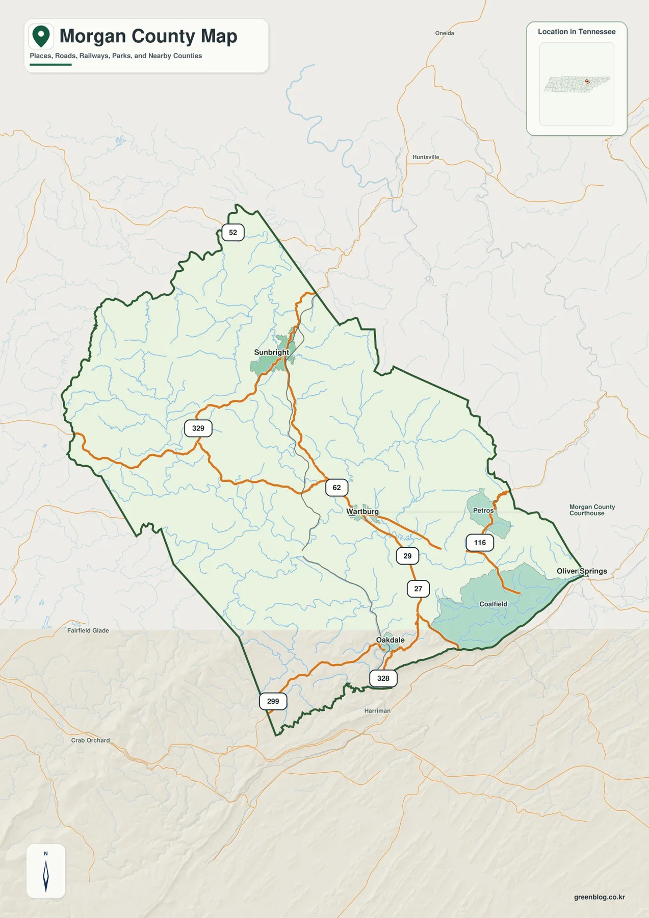
Table of Contents
Wartburg sits between a northern and southern town pair
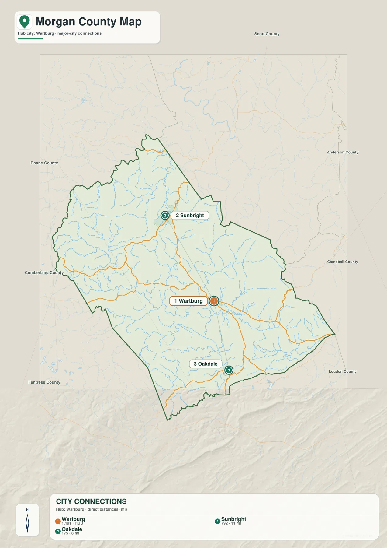
The city-connections sheet uses Wartburg as the hub. Sunbright is ranked second and is labeled 11 miles from Wartburg in a straight line, while Oakdale is ranked third at 8 miles. Those numbers are direct distances, not road mileage. Their value is in orientation: Sunbright identifies the northern part of the county and Oakdale anchors the southern edge, so the three labels form a useful north–center–south framework before any smaller place or road is considered.
Wartburg lies slightly east of the county’s center and Route 62 runs through town. Sunbright sits much farther north where the county narrows, while Oakdale is close to the southern boundary. The general county map adds Petros to the east along Route 116 and Coalfield farther southeast. This arrangement shows that settlement is divided among several valleys rather than concentrated in one broad urban corridor.
The surrounding county names give another layer of orientation. Scott County is to the north, Anderson and Campbell counties appear to the northeast and east, and Roane, Cumberland, and Fentress counties frame the south and west. Loudon County is labeled beyond the southeastern side. Oakdale is especially easy to understand when the southern boundary is visible, and Sunbright’s position becomes clearer when the northern approach toward Scott County is included.
Route 62 crosses a county broken by ridges and stream valleys
Route 62 is the easiest road to follow on the reference sheet because it passes through Wartburg and continues across the middle of the county. Route 329 approaches from the west, Route 116 serves the Petros side, and route shields 27 and 29 appear south of Wartburg on the approach toward Oakdale. The map also labels 328 and 299 near the southern boundary. These numbers are useful landmarks, but their shapes on the page are just as important as their names.
West of Wartburg, the roads cross broad rolling ground and bend gradually. East of town, the map becomes more constrained. The elevation sheet shows narrow high ridges packed around the Petros side of the county, and the roads weave through lower gaps between them. That contrast helps explain why a route that looks short in straight-line distance can follow a longer curved path once the terrain is taken into account.
The Oakdale area adds a different example. Roads there lie close to the southern boundary and follow lower terrain before leaving the county. North of Wartburg, the route toward Sunbright crosses a less densely settled section with many small drainage lines. For readers trying to understand the map rather than navigate turn by turn, these three settings—western rolling ground, eastern ridges, and southern valleys—are more informative than a long inventory of highway designations.
Obed River meets an Emory-centered drainage network
The water sheet is dominated by Obed River and the Emory River system. Obed River enters from the west and curves across the south-central county, while Emory River is labeled farther east and receives water from a dense set of tributaries. New River runs along the eastern side, and Little Emory River forms a long drainage line near the southeast. Instead of one simple river corridor, Morgan County contains several systems that collect water from different groups of valleys.
White Oak Creek is one of the clearest northern tributaries, with Bone Camp Creek nearby. Rock Creek appears in the northwest and Clear Creek in the west. Little Rock Creek lies near the center, while Crooked Fork Creek, Island Creek, and Mill Creek occupy the southern half. These named streams make it easier to connect the blue drainage lines with the ridges and low ground shown on the elevation sheet.
At the southern edge, Grand Orchard Creek and Little Emory River continue toward larger water bodies outside the county. The water map is a geographic reference, not a flood forecast or boating chart, so the important information here is the arrangement of channels and valleys. Tracing Obed River eastward and then comparing Emory River, New River, and Little Emory River reveals a county whose western plateau and eastern mountains are cut by distinctly different drainage patterns.

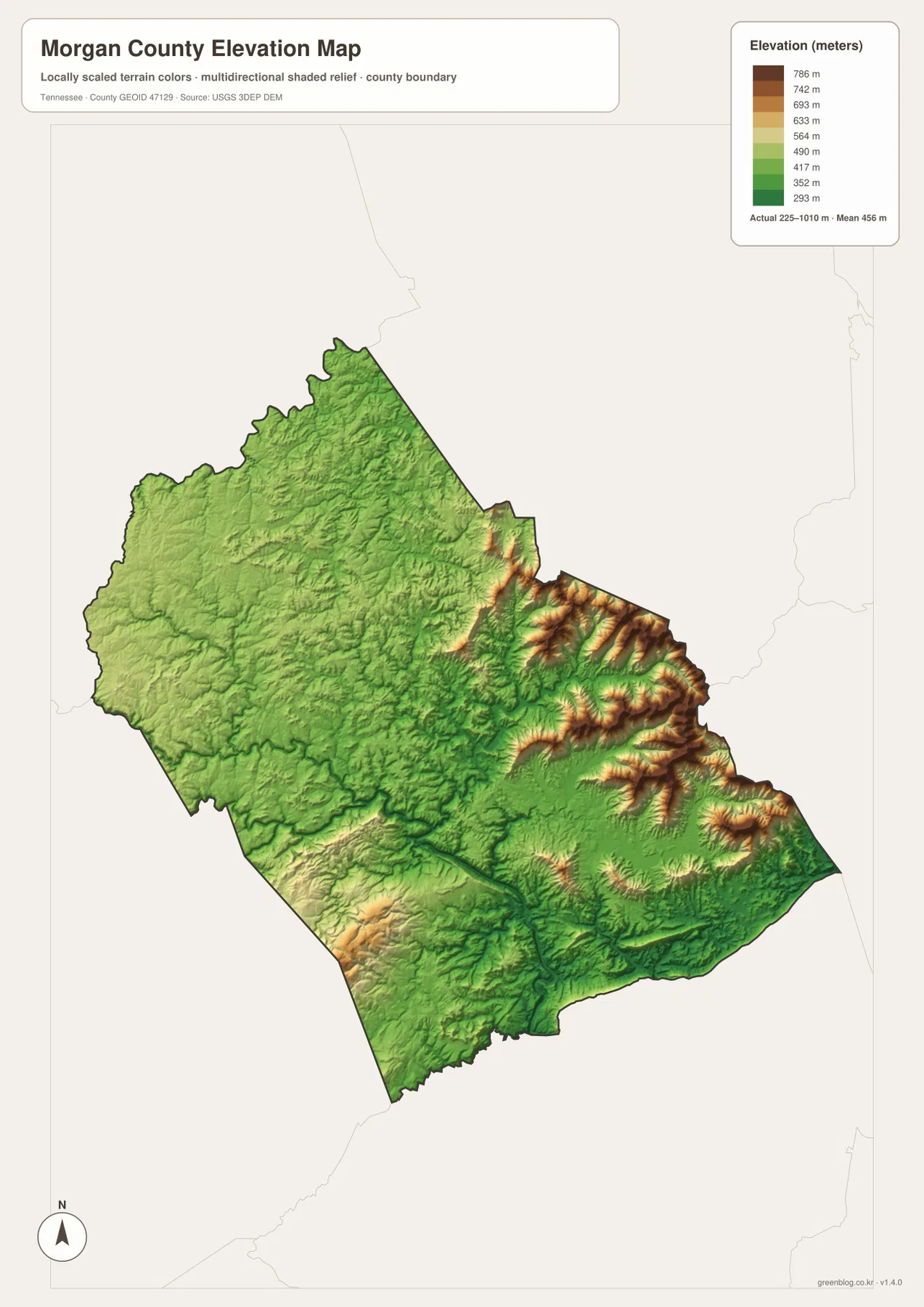
Relief jumps from about 225 to 1,010 meters
The elevation sheet lists an actual county range of about 225 to 1,010 meters and a mean near 456 meters. That spread is unusually important to the way this map looks. Broad green and yellow-green terrain covers much of the west and northwest, while the eastern side contains concentrated bands of orange and brown. The difference between the lowest valleys and highest terrain exceeds 700 meters within one county.
East of Wartburg toward Petros, the high ground is not one continuous block. Long ridges run roughly northeast to southwest with narrow lower valleys between them. New River and tributaries of Emory River occupy some of those low corridors, so the water map and elevation map reinforce each other. Roads also tend to use the lower passages, which is why the transportation pattern becomes more winding in this part of the county.
The western half is lower overall but still far from flat. Obed River and Clear Creek occupy visible depressions, and rolling ridges rise between their tributaries. The southwest rises again in places, while the southern edge around the Oakdale side contains a mix of valley floors and higher ground. The most useful way to read this sheet is therefore as a contrast among eastern mountain ridges, central river valleys, and the broader western plateau rather than as a search for one isolated summit.
County facts that make the map easier to interpret
- Official name: Morgan County, Tennessee
- County seat: Wartburg
- FIPS code: 47129
- County created: 1818
- 2020 Census population: 21,035
- July 2025 population estimate: 22,160
- Land area: about 522.2 square miles
- Elevation shown on this map: about 225–1,010 m, mean about 456 m
The 2020 Census count and the July 2025 estimate are different types of population figures, so they are best kept side by side rather than treated as interchangeable measurements. The county’s roughly 522.2 square miles of land also helps explain why Wartburg, Sunbright, and Oakdale feel widely separated on the map. The settlement pattern occupies only a small part of a much larger landscape of ridges, stream valleys, forested-looking terrain, and rural road connections.
The Tennessee State Library and Archives county fact sheet identifies 1818 as the creation year and Wartburg as the county seat. That administrative fact explains why the city-connections sheet uses Wartburg as the hub even though the map’s geographic story extends far beyond the town itself. It also separates the county-seat role from the wider pattern of small communities and rural valleys.
Which Morgan County sheet should you use?
Start with the county reference map when you need one page that combines towns, major route labels, the boundary, and nearby counties. It is the most useful sheet for explaining where Wartburg sits relative to Sunbright, Petros, Coalfield, and Oakdale. The city-connections map is cleaner when the goal is specifically to compare Wartburg with Sunbright and Oakdale, because the direct distances are printed beside the ranked city names.
Choose the water map when rivers and valleys are the main subject. Obed River, Emory River, New River, and Little Emory River are easier to follow without the heavier road labeling of the reference map. Open the elevation sheet beside it when you want to explain why those rivers occupy certain corridors. The green lowlands and brown ridges provide a visual link between drainage and relief that is difficult to see from the county outline alone.
The downloadable ZIP contains high-resolution JPG versions of all four sheets. Preserve the original aspect ratio for A3 printing, and make route or note annotations on a copy if the maps will be reused for a project. These static files are intended for geographic reference; current road closures, trail access, property boundaries, and other time-sensitive or legal details should be checked with the appropriate agency before they are used for decisions.
Frequently Asked Questions
How far are Sunbright and Oakdale from Wartburg on the city map?
The city-connections sheet labels Sunbright 11 miles from Wartburg and Oakdale 8 miles from Wartburg. Both are straight-line distances rather than driving mileage. Sunbright lies north of the hub, while Oakdale lies south near the county boundary.
How do Obed River and Emory River divide the county?
Obed River crosses the western and south-central portion of Morgan County, while the Emory River system is more prominent through the center and east. Smaller streams such as Little Rock Creek and Crooked Fork Creek occupy valleys between them, and New River adds another major drainage line along the eastern side.
What stands out most on the Morgan County elevation map?
The strongest feature is the sharp contrast between high eastern ridges and lower central and western valleys. The displayed actual range is about 225 to 1,010 meters, with a mean near 456 meters. Comparing the elevation sheet with New River and Emory River tributaries makes the relationship between low valleys and steep ridges especially clear.
Map File Information
The ZIP contains high-resolution JPG versions of the county, city-connections, water, and elevation maps used on this page. The files retain the original layout for A3 printing and detailed viewing.
- Included Files: county, city, water, and elevation JPGs
- File Type: JPG files in one ZIP archive
Related Maps
- Alamo to Gadsden: A Crockett County Tennessee Map
- Altamont, Monteagle, and Plateau Valleys — Grundy County Tennessee Map
- Around Chattanooga: Hamilton County Tennessee Map
Sources and references
- Tennessee State Library and Archives — Morgan County fact sheet
- Tennessee Department of Transportation — Morgan County road map
- U.S. Census Bureau QuickFacts — Morgan County, Tennessee
- U.S. Census Bureau TIGER/Line boundary data
- USGS National Hydrography
- USGS 3D Elevation Program
Green Map creates custom-edited map images using open geographic data sources such as geoBoundaries, Natural Earth, OpenStreetMap, and government open data. These maps are edited visual materials, not raw data files, and are provided for education, documents, presentations, and graphic reference.