Hertford County sits in northeastern North Carolina, where small towns, rural roads, and the Chowan River are more useful for orientation than a single large urban center. Winton is the county seat, Ahoskie is the most prominent settlement on the supplied city map, and Murfreesboro forms another distinct center in the northwest. The maps on this page show the county boundary and roads, the distribution of six named communities, and the local river and creek network. A ZIP containing the matching high-resolution JPG files is available in the download box below.
For a first look, find Ahoskie near the southern part of the county and Winton farther northeast. Then move toward Murfreesboro in the northwest and trace the Chowan River along the eastern side of the county. That sequence makes the map easier to understand because Hertford County does not revolve around one dominant city. Its administrative center, larger settlement, historic river town, road connections, and waterways occupy different parts of the county.
Table of Contents
Hertford County between Virginia and the Chowan River
Hertford County is part of North Carolina’s northeastern Coastal Plain. Its northern edge reaches the Virginia state line, while Northampton County lies to the west, Bertie County to the southwest, Gates County to the northeast, and Chowan County to the east. Those surrounding names appear around the supplied maps and are useful when the county shape is unfamiliar. The county occupies an inland position, but the Chowan River gives its eastern and southeastern side a strong water-based reference.
The county was formed in 1759 from parts of Bertie, Chowan, and Northampton Counties, and Winton serves as the county seat. That history is not necessary for using the map, but it helps explain why Hertford County is best understood in relation to several neighboring counties rather than as an isolated block. The boundary bends around river and creek areas in the north and east, while the southern side is more regular. The overall landscape belongs to the low Coastal Plain, so major mountain relief is not the defining feature here; rivers, creeks, swamps, farms, roads, and small communities matter more for everyday orientation.
There is also an easy naming trap for visitors. Hertford County is not the same place as the town of Hertford in Perquimans County. Within this county, the seat is Winton. Chowan County is a neighboring county, while the Chowan River is the major river system shown on the water map. Keeping those names separate is useful when searching for addresses, comparing county maps, or moving between regional reference pages.
Roads and settlements from Ahoskie to Winton and Murfreesboro
The county reference map gives the clearest overview of roads, communities, nearby counties, and the outer boundary. Ahoskie appears near the southern center with the largest built-up area on the map. Winton is northeast of Ahoskie and is marked close to the Hertford County Courthouse. Murfreesboro lies in the northwest, Como is farther north, Cofield sits southeast of Winton, and Harrellsville occupies the eastern part of the county. The pattern immediately shows that Hertford County has several separated local centers rather than one continuous urban area.
The road network helps connect those centers. Route numbers 258 and 158 are visible around Murfreesboro, while 561 crosses the western and central part of the county. Around Ahoskie, the map shows 11, 42, and 13, giving that community several directional connections. Route 45 appears near Harrellsville on the eastern side, and other local roads branch toward Winton and Cofield. These labels are useful for understanding the county-scale road pattern, but the map is not a live navigation product and should not be used for current traffic, closures, or turn-by-turn driving instructions.
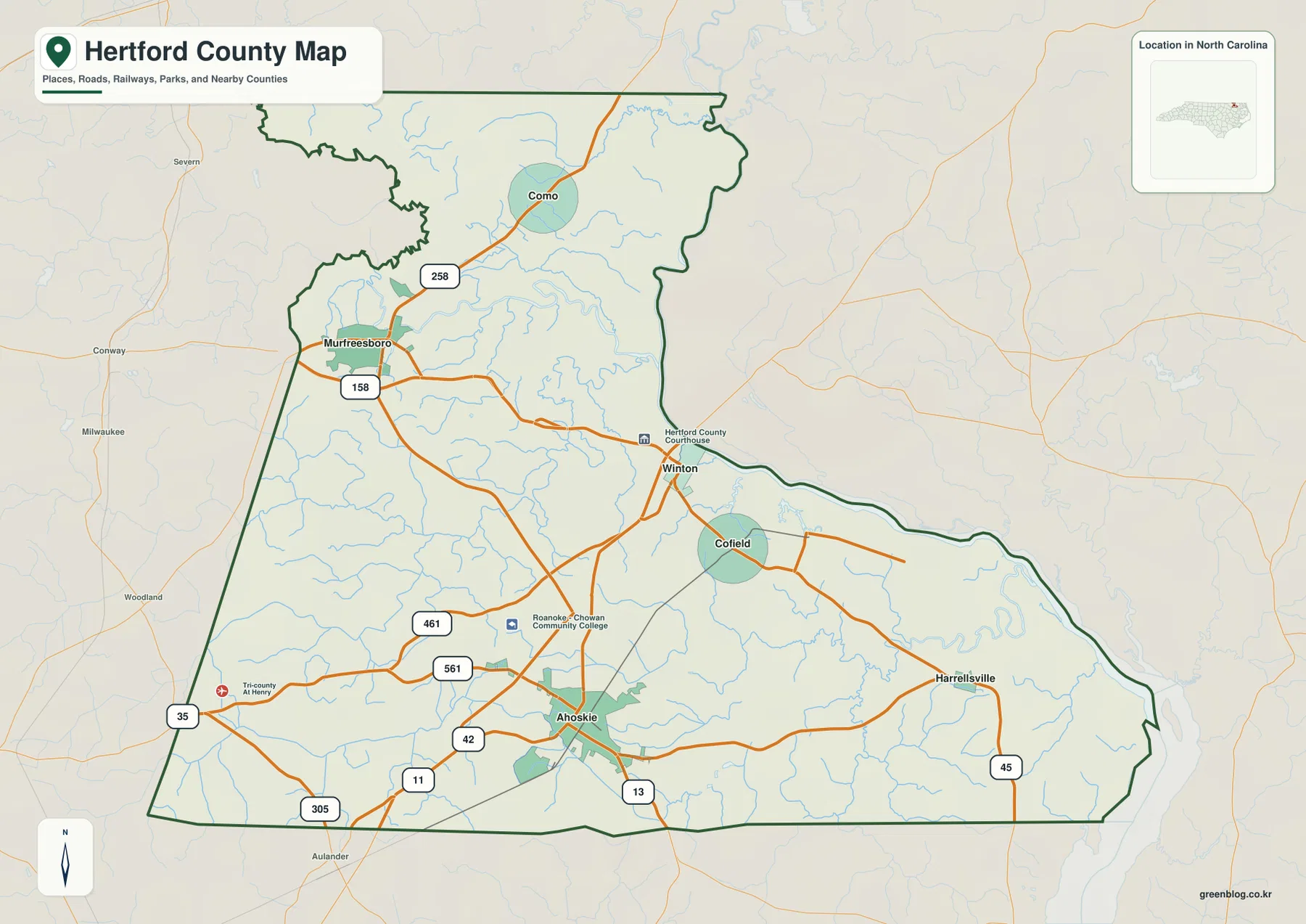
A practical way to read this map is to start with the dark green county outline and then place Ahoskie and Winton inside it. Add Murfreesboro and Como to the north and northwest, then look east toward Harrellsville and southeast toward Cofield. Nearby labels such as Severn, Conway, Woodland, and Aulander sit outside the county and help show which direction the road network continues after crossing the boundary. That makes the map useful not only for locating places inside Hertford County, but also for understanding its position within the surrounding northeastern North Carolina road network.
The map also includes a few institutional or landmark symbols, including Hertford County Courthouse and Roanoke-Chowan Community College. They work as recognizable reference points, not as a complete directory of schools, public buildings, parks, or services. If a visitor needs a street address, current operating information, or a detailed campus plan, a separate local source will be more appropriate. The purpose of this map is broader: it shows how the main settlements, roads, boundary, and neighboring areas fit together at county scale.
A county seat, a larger town, and several smaller communities
The city distribution map removes much of the extra road detail and makes the settlement pattern easier to compare. Its City Index ranks Ahoskie first, Murfreesboro second, Winton third, followed by Cofield, Harrellsville, and Como. The important point is not simply the ranking. It shows that county-seat status and settlement size are different ideas. Winton is the administrative center, while Ahoskie appears as the larger population center in the supplied map data. Murfreesboro adds another substantial community in the northwestern part of the county.
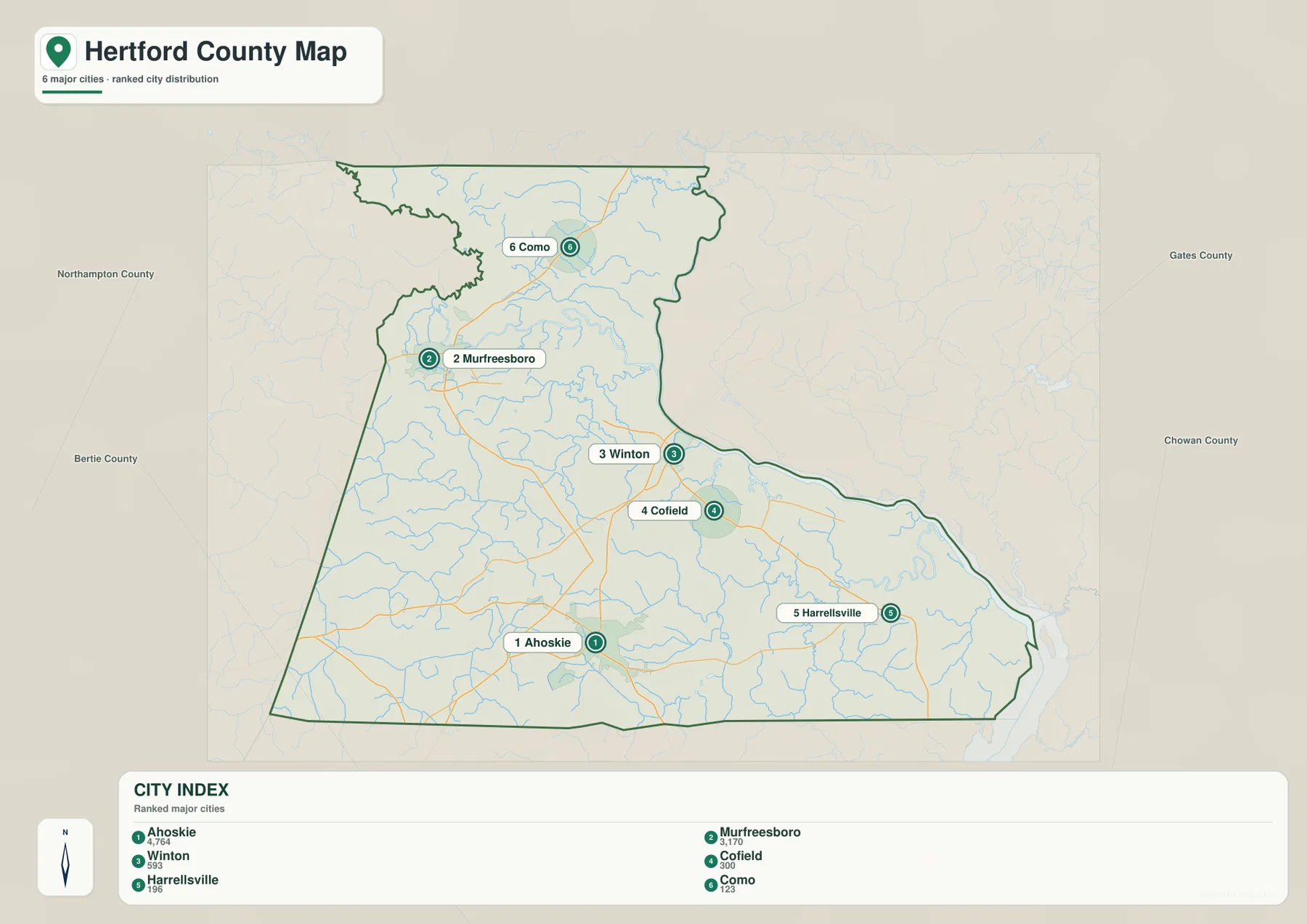
Ahoskie is positioned in the southern part of the county and is connected to several of the routes visible on the reference map. Murfreesboro is clearly separated in the northwest near the Meherrin River area. Winton sits east of the county’s center, with Cofield farther southeast. Harrellsville is near the eastern side, while Como is in the north. Because these places are spread over a large rural area, a map that shows all of them at once is often more useful than a close-up of the county seat alone.
The population figures printed in the City Index should be read as the map’s source values rather than treated as a statement of today’s official population. Population counts change by year and by the geographic unit being measured. For this page, the more durable information is the relative location of each community. Ahoskie provides a southern anchor, Murfreesboro a northwestern anchor, Winton the administrative reference, and the smaller communities fill the eastern, central, and northern parts of the county.
The wide margins on the city map also identify surrounding counties. Northampton appears to the west, Bertie to the southwest, Gates to the northeast, and Chowan to the east. This makes it easier to see which communities are closer to different county edges. Murfreesboro is nearer the western side, Harrellsville sits toward the east, and Ahoskie is much farther south. For regional comparisons, those positions matter more than a simple alphabetical list of town names.
The Meherrin, Chowan, and a dense network of creeks
The terrain and water map shifts attention away from roads and toward the county’s natural drainage network. The Meherrin River enters the northwestern part of Hertford County and continues southeast toward the Chowan River system. The Chowan becomes the dominant water feature through the central-eastern and southeastern area. Around those rivers, the map labels Buckhorn Creek in the north, Potecasi Creek farther south, Cutawhiskie Creek and Ahoskie Creek in the southwestern and southern area, plus Wiccacon River and Chinkapin Creek toward the southeast.
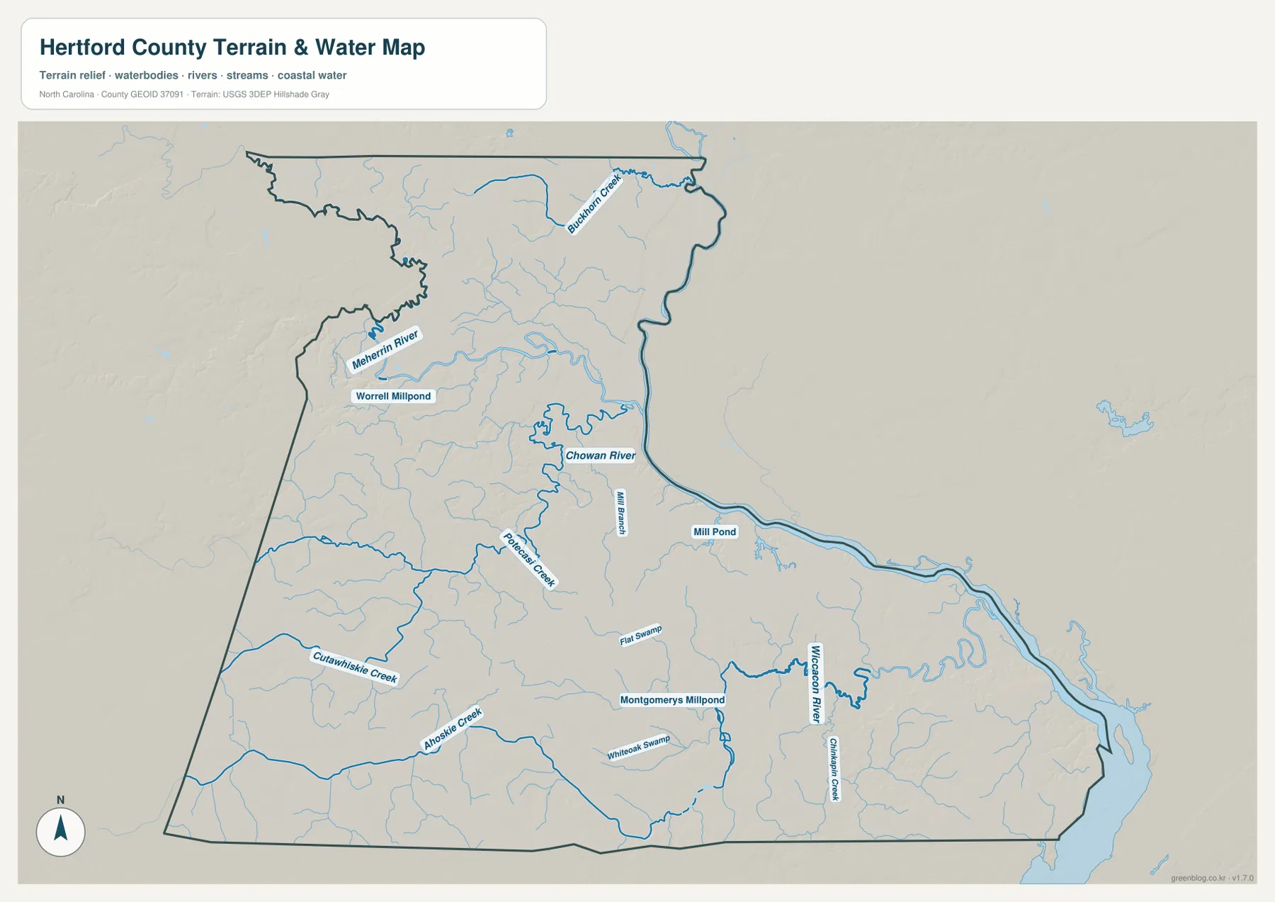
The Chowan River is drawn with a broad, strong blue line, so it is easy to separate from the smaller tributaries. The Meherrin approaches from the northwest and joins the larger system, while the southern creeks run across the flatter interior. The map also labels Worrell Millpond, Mill Pond, and Montgomerys Millpond, along with areas named Flat Swamp and Whiteoak Swamp. Together, those features show that local water geography is not limited to one river channel; the county contains a finer network of creeks, ponds, and low wet areas.
The shaded background gives a general sense of terrain relief, but this is not a separate elevation map and it should not be read as survey-grade height data. Hertford County belongs to the Coastal Plain, where dramatic mountain relief is absent. On this map, the waterways and low-lying drainage features are more informative than small differences in shaded terrain. The map is useful for seeing where named rivers and creeks lie relative to the county outline, but it does not show parcel boundaries, engineering elevations, or legally surveyed water limits.
It is also important not to treat this water reference as a flood map. A creek or swamp label does not by itself indicate a current flood hazard, protected wetland boundary, boating condition, or development restriction. Those questions require purpose-built official datasets. What this map does well is geographic orientation: it shows how the Meherrin approaches the Chowan, where the main southern creeks run, and why the eastern side of Hertford County is closely tied to the Chowan River system.
Choose the map that matches the question
Use the county reference map when you need roads, nearby counties, the outer boundary, and major settlements in one view. Use the city distribution map when the main goal is comparing Ahoskie, Winton, Murfreesboro, Cofield, Harrellsville, and Como without as much extra detail. Use the terrain and water map for the Chowan River, Meherrin River, creeks, millponds, and the county’s drainage setting. The three files cover the same place, but each one removes some information so another kind of information is easier to see.
That distinction is especially useful for printed material. A classroom handout about county location may work best with the reference map. A local settlement comparison can use the city map, while a lesson or presentation about waterways will be clearer with the water map. The JPG downloads are larger than the web previews, so they are the better choice when text and labels need to remain readable on a printed page or a larger screen.
After downloading the ZIP, begin with the county reference map if you are not familiar with Hertford County. Once Ahoskie, Winton, Murfreesboro, and the outer boundary make sense, switch to the city or water map for a more focused view. For parcel information, current traffic, flood zones, legal boundaries, or other specialized questions, use the appropriate official source in addition to these general-purpose maps.
Frequently Asked Questions
Why does Ahoskie look more prominent than Winton if Winton is the county seat?
Winton is the administrative seat of Hertford County, but the supplied city map ranks Ahoskie as the larger settlement. A county seat identifies the location of county government; it does not have to be the county’s largest town. Use Winton as the administrative reference and Ahoskie as the stronger southern settlement reference when comparing locations on these maps.
How do the Meherrin and Chowan rivers relate to each other on the map?
The water map shows the Meherrin River entering from the northwest and continuing southeast into the Chowan River system. The Chowan then provides the larger eastern and southeastern water reference for the county. Looking at both rivers together helps connect the Murfreesboro area in the northwest with the broader river network on Hertford County’s eastern side.
What is included in the downloadable ZIP?
The current package includes three high-resolution JPG files: the Hertford County reference map, the city distribution map, and the terrain and water map. The images in the article are web previews. There is no separate elevation map or land-cover map in this download, so the ZIP description is limited to the three map types actually supplied.
Map File Information
Download the high-resolution JPG versions of the Hertford County reference map, city distribution map, and terrain and water map. The ZIP contains the three JPG files that correspond to the maps shown on this page.
- Included Files: county reference map JPG, city map JPG, terrain and water map JPG
- File Type: ZIP containing 3 JPG images
Related Maps
Sources and References
- NCpedia – Hertford County: county formation, county seat, communities, and regional background
- U.S. Census Bureau TIGER/Line Shapefiles: boundary, road, and place-reference data
- USGS National Hydrography: river, stream, and hydrography reference data
Green Map creates custom-edited map images using open geographic data sources such as geoBoundaries, Natural Earth, OpenStreetMap, and government open data.
These maps are edited visual materials, not raw data files, and are provided for education, documents, presentations, and graphic reference.