Download the high-resolution A3 JPG map ZIP for Sangamon County directly from this page. The archive contains the same county-and-road, major-city, water, and elevation views shown below, while the embedded WebP images are sized for faster browser viewing. Sangamon County is centered on Springfield, but the maps show that the county extends far beyond the capital-area street grid into western towns, southern communities, a broad Sangamon River valley, and gently higher ground toward the west and southwest.
Springfield is the easiest place to begin. Sherman lies to the north and Chatham to the south along the I-55 corridor, while Riverton and Rochester occupy the eastern side of the central area. Auburn is farther south, and Pleasant Plains, New Berlin, and Loami spread across the western half. After those community positions are familiar, the water and elevation maps reveal why the center and east contain long low corridors while the western and southwestern parts of the county are generally higher.
Table of Contents
Springfield and I-55 form the central frame
Springfield dominates the general county map. Its built-up area occupies a broad central space, and I-55 links Sherman to the north with Chatham to the south. Riverton lies northeast of Springfield and Rochester southeast, so the eastern communities do not form one straight line but instead spread around the central city. Williamsville sits farther north, while Auburn becomes the clearest southern reference point beyond Chatham.
The west side feels much more open. Pleasant Plains is northwest of Springfield, New Berlin and Berlin occupy the west-central area, and Loami lies farther southwest. Roads 36 and 72 help locate the New Berlin area, while 97 and 125 provide additional references between Springfield and the northwest. The difference between the dense central road network and the wider spacing in the west becomes obvious on the full county map.
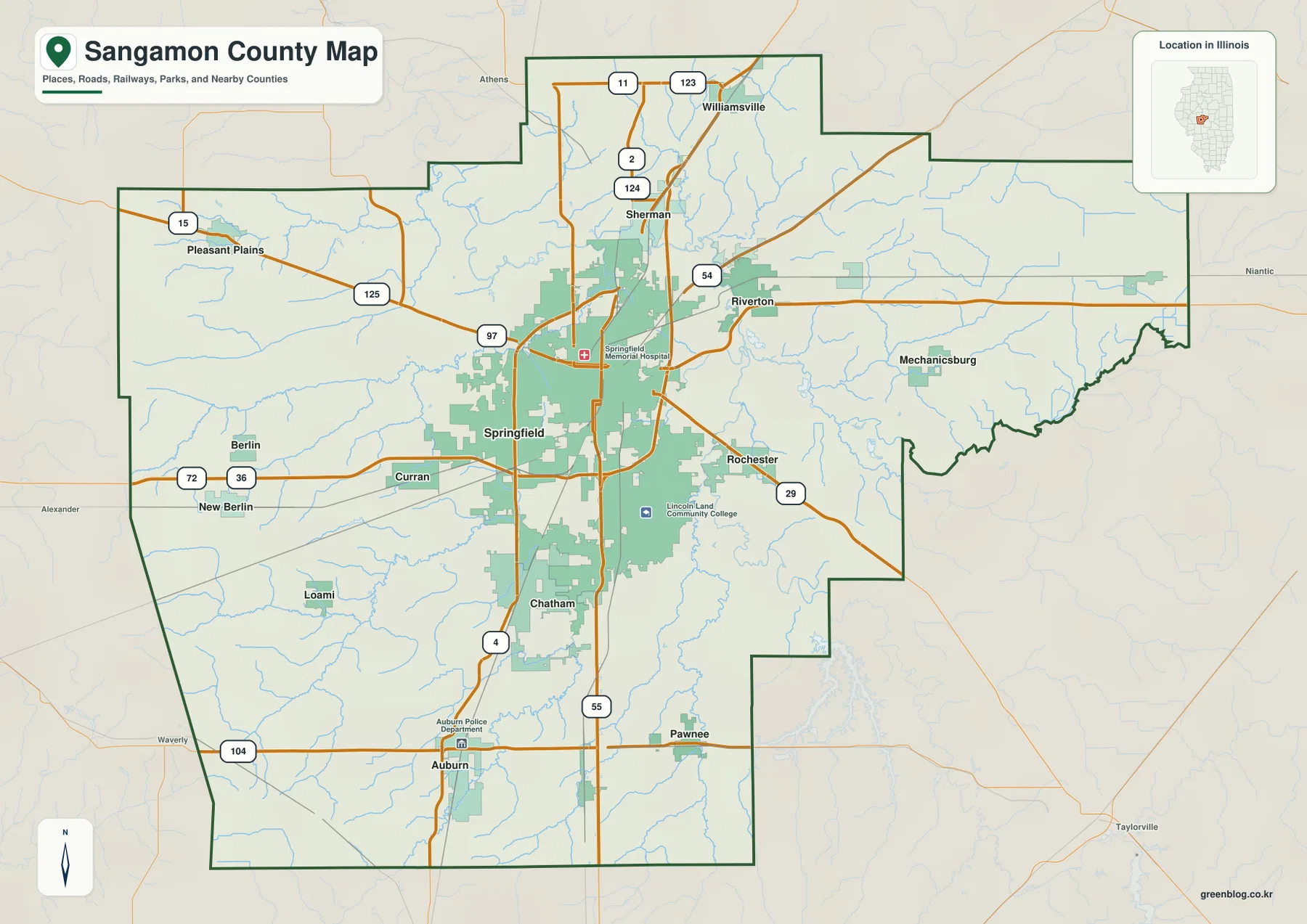
Roads are most useful when they are tied to the communities rather than read as an isolated list of numbers. I-55 provides the clearest north-south guide through the central county. East of Springfield, routes toward Riverton and Rochester approach the Sangamon River side of the county, while westbound roads lead into a landscape with fewer large settlements. The map therefore works best as a way to compare the compact Springfield-centered network with the more widely spaced towns around the county edges.
The eastern edge also looks different from the west because the county boundary becomes more irregular near the Sangamon River system. Mechanicsburg lies farther east of Riverton, and smaller roads and streams become more prominent beyond Rochester. Once the major communities are located, these changes in map detail help explain where the urban concentration ends and where the broader rural county begins.
The six-city index shows a center with one long southern extension
The city-index map removes most smaller labels and highlights six places. The supplied index ranks Springfield first with 113,330, Chatham second with 14,639, Sherman third with 4,386, Auburn fourth with 4,306, Rochester fifth with 3,766, and Riverton sixth with 3,513. These are values printed on the supplied map and are not presented here as newly verified current population counts.
Location is more useful than the ranking itself. Springfield sits at the center, Chatham continues directly south, and Sherman is north. Riverton lies northeast and Rochester southeast, placing the two eastern communities on opposite sides of the Sangamon River side of the central area. Auburn is the clear outlier among the six because it is much farther south. The result is a Springfield-centered pattern with one long southern extension rather than an evenly spaced line of towns across the county.
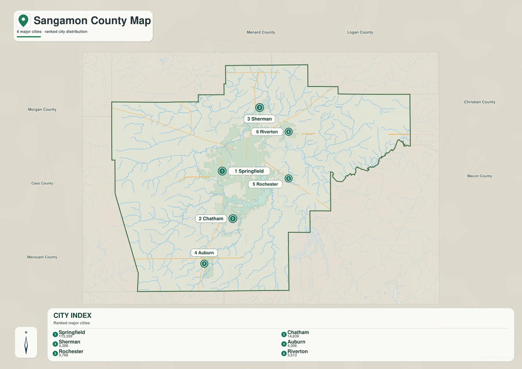
This simplified view leaves out places such as Williamsville and Pleasant Plains, but that is useful when the goal is to see the main city cluster without extra road detail. Chatham and Sherman line up clearly on the north-south corridor, while Rochester and Riverton sit east of Springfield in different directions. The full county map remains better for locating smaller communities, but the city index makes the central concentration and Auburn’s southern separation immediately visible.
Sangamon River and Lake Springfield connect a web of creeks and lakes
The water map is organized around the Sangamon River. It descends through the north-central part of the county, passes east and northeast of Springfield, and continues toward the eastern boundary. South of Springfield, Lake Springfield forms the largest standing-water feature on the map and provides an easy reference for the southern side of the central urban area. The river and lake together define much of the county’s broad central lowland.
Spring Creek crosses a long section of the west-central county, while Richland Creek appears in the northwest. Frontier Lake and Halfmoon Lake sit between those drainage areas, and Mud Lake is farther north-central. Clear Lake is close to the Sangamon River, with Clear Creek farther east. Grouping the water features this way is easier than trying to read every tributary at once: Richland Creek in the northwest, Spring Creek in the west, the Sangamon River through the center, and Lake Springfield to the south form four practical anchors.
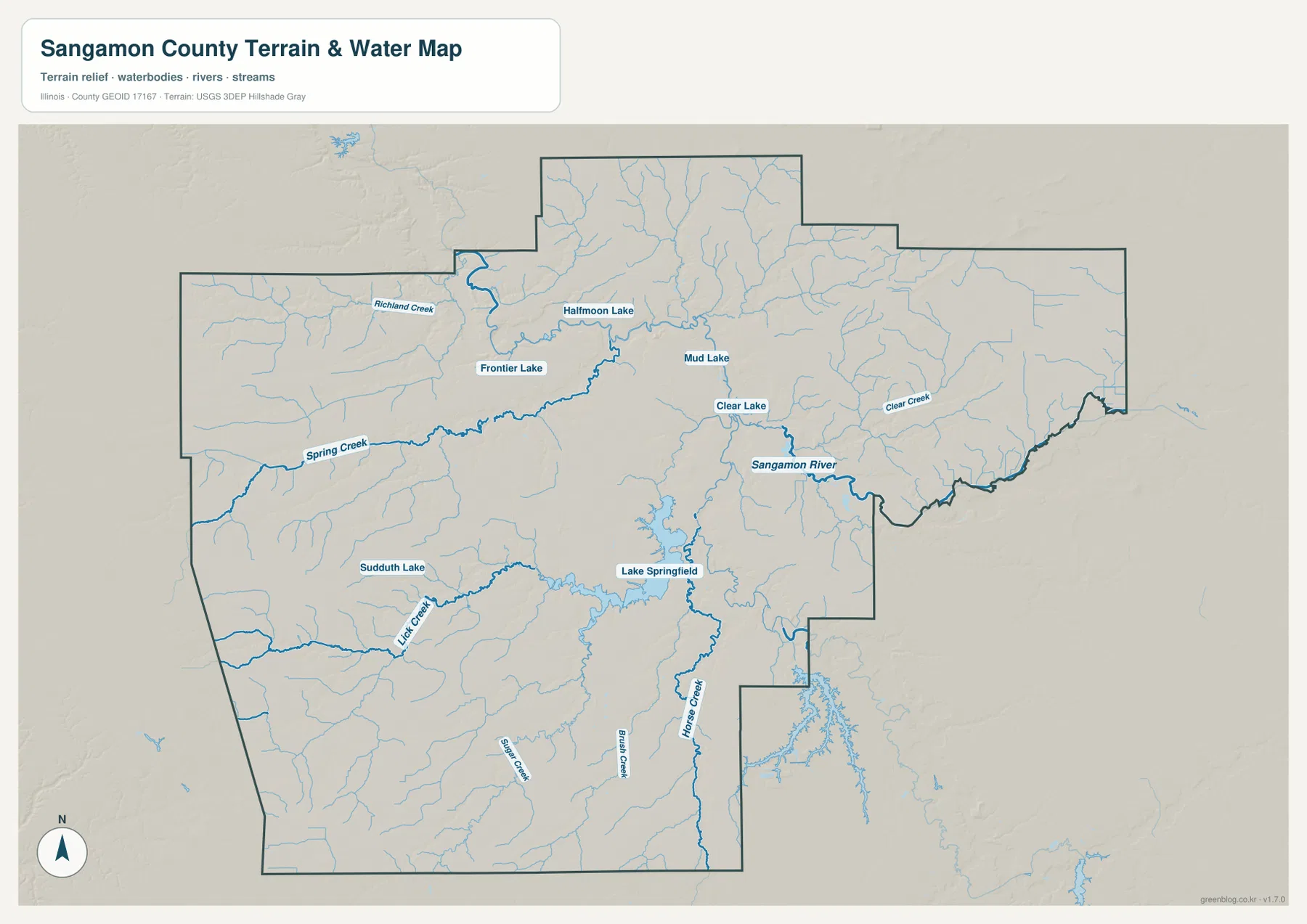
Farther southwest, Sudduth Lake and Lick Creek provide another pair of local markers. Sugar Creek and Brush Creek are labeled across the southern half, while Horse Creek extends southward east of Lake Springfield. These smaller waterways correspond to many of the low green lines on the elevation map. Even though Sangamon County has moderate relief overall, its surface is divided by a fine network of shallow valleys.
The water layer is a general geographic reference rather than a flood-hazard, navigation, water-quality, parcel, or legal-boundary map. A stream or lake label shows relative location, not public access or a current regulatory condition. For floodplain, water-use, or legal questions, the relevant current official source should be used instead.
150 to 218 meters separates river lowlands from the west and southwest
The supplied elevation map reports an actual range of about 150 to 218 meters and a mean near 183 meters. The lowest green colors follow the Sangamon River and several tributary valleys through the central and eastern county, and Lake Springfield lies within another lower corridor. The west and southwest contain broader areas of tan and brown, with the southwestern corner reaching some of the highest colors on the map.
The higher western terrain is not a single flat surface. Spring Creek, Lick Creek, and many smaller tributaries cut lower green channels into it. Similar branching valleys appear in the northwest and gradually connect toward the Sangamon River lowland. Most of the east remains relatively low, although a small area near the northeastern boundary rises enough to stand out in warmer colors. The county is therefore gently rolling rather than perfectly flat.
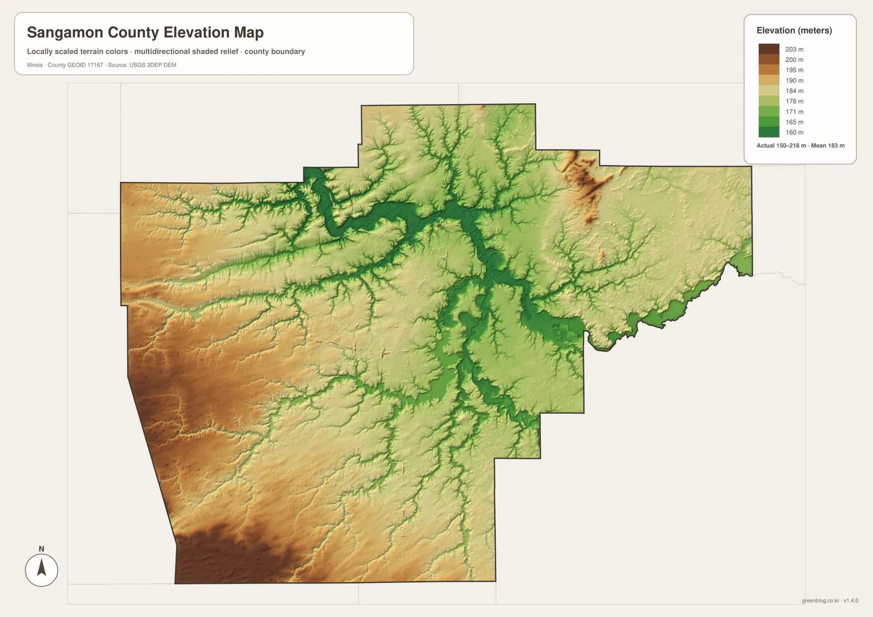
Relating elevation to the settlement map makes the pattern easier to understand. Springfield and Riverton lie close to the lower Sangamon River side of the county, while the landscape becomes more frequently elevated toward New Berlin, Pleasant Plains, Loami, and the southwest. Auburn is also surrounded by a mix of gentle higher ground and creek valleys. The differences are not mountainous, but they are large enough to explain why watercourses repeatedly occupy visible lower corridors.
The elevation layer is intended for county-scale comparison, not for parcel surveying or engineering design. The 150–218 m range helps identify the Sangamon River valley, tributary valleys, and the relatively higher west and southwest, but it does not provide a survey-grade elevation for a specific property. Construction, drainage design, flood work, and legal decisions require more precise current data.
Read the maps from city scale to terrain
For community locations and roads, begin with Springfield and trace I-55 north to Sherman and south to Chatham. Then move east to Riverton and Rochester and farther south to Auburn. If the question is limited to the six principal communities printed in the package, the city index is the fastest view. For water features, locate the Sangamon River and Lake Springfield first, then add Spring Creek, Richland Creek, Lick Creek, and Horse Creek.
The ZIP below contains the original high-resolution JPG files for the county-and-road map, city index, water map, and elevation map. Each image is 3638 × 2572 pixels in landscape orientation, making small road, stream, and community labels easier to enlarge or print than in the browser-sized WebP versions. These maps are general reference products, so current traffic, legal parcel boundaries, flood determinations, water regulations, or survey-grade elevations should be checked with the appropriate official source.
Frequently Asked Questions
How are the main Sangamon County communities arranged around Springfield?
Chatham lies south of Springfield, Sherman north, Riverton northeast, and Rochester southeast. Auburn is much farther south than the other principal places in the city index. The general county map is best for the full road network, while the city index makes the six-place pattern easier to compare.
Which water features are easiest to use as landmarks?
Sangamon River and Lake Springfield are the strongest anchors. Spring Creek and Richland Creek help organize the west and northwest, while Lick Creek and Horse Creek provide useful southern references. The water map also shows smaller lakes including Frontier Lake, Halfmoon Lake, Mud Lake, Clear Lake, and Sudduth Lake.
Where is the higher ground on the Sangamon County elevation map?
The west and southwest are generally higher than the Sangamon River lowland through the center and east. The supplied elevation map reports an actual range of about 150 to 218 meters and a mean near 183 meters, with the southwestern corner among the highest-colored areas.
Map File Information
The ZIP contains high-resolution A3 JPG versions of the Sangamon County road-and-boundary map, major-city index, water map, and elevation map.
- Printable Size: 3638 × 2572 pixels each
- File Type: ZIP containing 4 JPG files
Related Maps
Sources and references
- Official Sangamon County website – county government and local information
- Springfield Park District – Springfield and Lake Springfield area parks and local references
- Lincoln Memorial Garden & Nature Center – natural-area reference near Lake Springfield
- U.S. Census Bureau TIGER/Line Shapefiles – county boundaries, roads, and place references
- USGS National Hydrography – rivers, streams, and lakes
- USGS 3D Elevation Program – elevation and terrain reference
Green Map creates custom-edited map images using open geographic data sources such as geoBoundaries, Natural Earth, OpenStreetMap, and government open data.
These maps are edited visual materials, not raw data files, and are provided for education, documents, presentations, and graphic reference.