Hoke County is easiest to understand when Raeford is treated as the central road and service hub rather than as the whole county. The supplied maps show a broader pattern: smaller communities such as Five Points, Bowmore, Dundarrach, Ashley Heights, and Rockfish spread away from the seat, while creeks and swampy drainages cross the interior in several directions. This page brings those pieces together and provides downloadable A3 JPG map files for visitors who need a larger copy for printing, classwork, presentations, or local reference.
The general county map is the best starting point because it combines the county outline with roads, community labels, water lines, and nearby places. The city-index map simplifies that picture and makes Raeford the main urban reference. The terrain-and-water map does almost the opposite: it reduces the emphasis on roads and settlements so that Rockfish Creek, Jumping Creek, Raft Swamp, ponds, and other named waters become the main features. Reading the maps together gives a much more complete view than relying on a single label or road corridor.
Table of Contents
Raeford at the center of Hoke County roads and communities
On the county map, Raeford sits near the middle of the county and is surrounded by several converging roads. NC 211 crosses the central area and continues west toward Five Points, while US 401 approaches Raeford from the southwest and continues through the central road network. NC 20 is labeled toward the southeast near Dundarrach, and US 15 and US 501 appear along the western side near Ashley Heights. The road pattern makes Raeford a practical point of orientation even before any city ranking is considered.
The same map keeps smaller places visible. Five Points lies west of Raeford, Bowmore is to the southwest, Dundarrach is southeast of the seat, and Rockfish is on the eastern side. Silver City is shown immediately around the Raeford area, while Ashley Heights sits much closer to the northwestern boundary. These labels matter because Hoke County does not read as a single compact settlement. A visitor looking only at Raeford would miss how far the county extends toward the western communities and how the eastern side approaches the Cumberland County area.
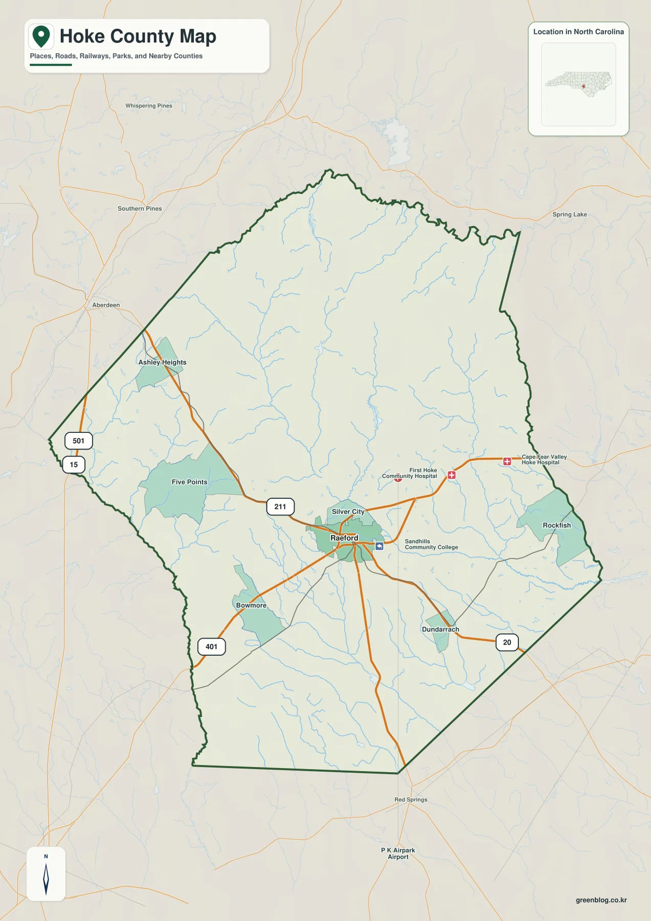
Several places outside the county outline help with regional orientation. Southern Pines and Aberdeen appear to the northwest, Spring Lake is shown to the northeast, and Red Springs appears south of the county. They should not be read as Hoke County communities; instead, they show where the county sits in relation to better-known nearby places. That broader frame is especially useful for someone approaching Hoke County from another part of North Carolina and trying to understand which side of the county is closest to the Sandhills communities or the Fayetteville side.
The county map also includes hospitals and Sandhills Community College near the Raeford area. Those symbols add useful context without turning the map into a street-level directory. Because the map is designed as a county reference, it is best for relative location: which community is west or east of Raeford, which major route crosses a given part of the county, and how far the county outline extends around the central settlement. It should not replace current turn-by-turn navigation or a parcel map.
Why the city-index map puts Raeford first
The city map is deliberately simpler. Its CITY INDEX lists Raeford as the major city, and the map places a numbered marker on Raeford near the center of the county. Smaller communities that appear on the general county map are not given the same ranking here. That difference is useful rather than contradictory: the city map answers the narrower question of where the principal city reference lies, while the county map is better when the goal is to find named communities across the full county.
County names around the frame make the city map useful for regional direction. Moore County is labeled to the north, Cumberland County to the east, and Richmond, Scotland, and Robeson Counties appear around the western and southern sides. Harnett County is also labeled farther to the east in the surrounding map frame. These labels provide a larger geographic setting; they should not automatically be interpreted as proof that every name shown shares a direct border with Hoke County.
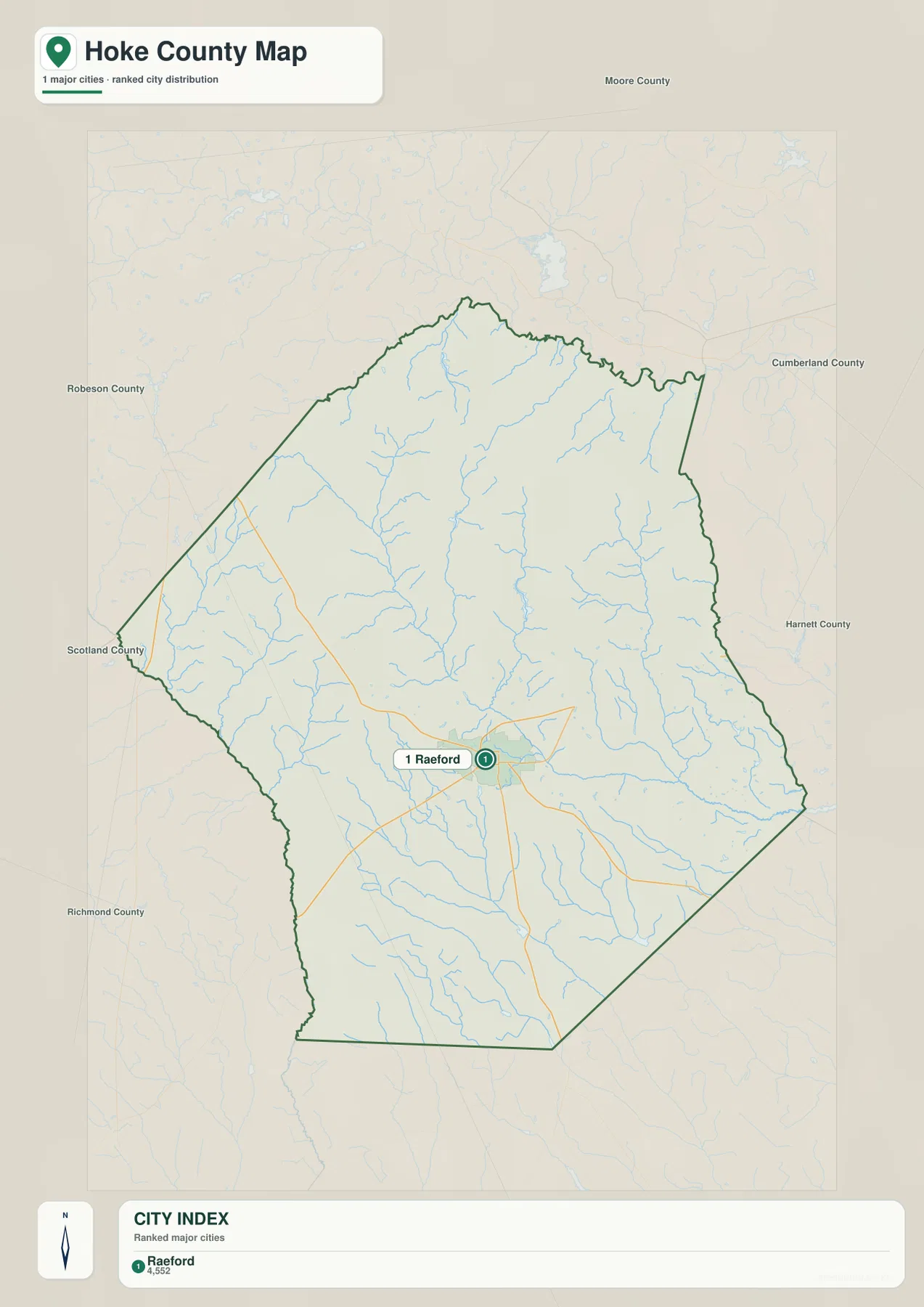
Raeford is therefore the easiest place to use as a starting point when explaining Hoke County to someone unfamiliar with the area. From that center, the general county map can be used to add Rockfish on the east, Five Points on the west, Bowmore on the southwest, and Dundarrach on the southeast. The two maps work well as a pair because the first keeps the county detailed while the second removes much of that detail and makes the urban center immediately obvious.
This distinction also prevents a common reading mistake. A city-index map is not a complete inventory of every populated place, and a community that does not appear in the ranked index has not necessarily disappeared from the county. In Hoke County, the smaller labels on the general map are important for understanding the spread of settlement around Raeford. The city map is best used for hierarchy and orientation, not as a substitute for the fuller community map.
From Rockfish Creek to Raft Swamp: the water network across Hoke County
The terrain-and-water map changes the emphasis completely. Rockfish Creek is a prominent named channel in the western and central part of the county. Nearby, Jumping Creek and Nicholson Creek form additional north-to-south water references through the interior, while Puppy Creek is labeled on the eastern side. Gulf Branch appears closer to the eastern boundary. With the road labels removed, these waterways stand out as a connected natural framework rather than background lines beneath the transportation network.
The map also names several still-water features. Lake Bay and Lake MacArthur appear near the northwestern side, Mc Kiethan Pond is shown in the central area, and Williamson Pond is farther south. Hodgins Pond and Greenbrier Lake are labeled in the southern portion of the county. These names are helpful when a visitor is trying to match a local water feature with its general position inside Hoke County, especially because many of them are easy to overlook on a map designed primarily around highways and communities.
South of the central creeks, Raft Swamp becomes an important label. Little Raft Swamp is also shown nearby, and the wider drainage area extends toward the southern part of the county. The Lumber River label appears outside the southwestern edge of the county map frame. This southern section has a visibly different water vocabulary from the northern and central sections: “creek” labels are joined by “swamp,” ponds, and lakes. That does not by itself establish wetland boundaries or flood zones, but it does show why a water-focused map adds information that a road map cannot.
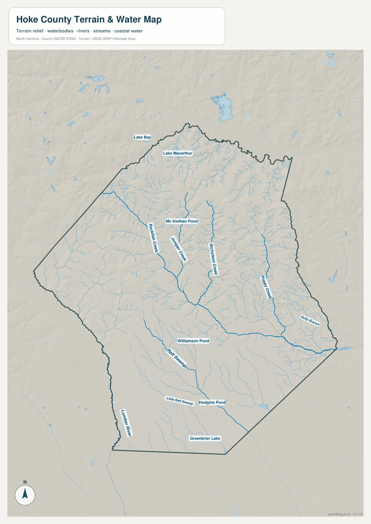
Subtle shaded relief is visible behind the water network. It helps the viewer see broad terrain form and the way water lines sit within that surface, but the map does not provide surveyed spot elevations or engineering measurements. It is appropriate for visual orientation and for comparing named drainages. It is not an elevation certificate, construction survey, floodplain determination, or navigation chart. Anyone making a legal, engineering, or hazard decision should use the specialized official source for that purpose.
What each Hoke County map is best at showing
The three supplied maps overlap, but each one solves a different reading problem. The general county map is the most complete reference for communities and transportation because it combines Raeford, Rockfish, Five Points, Bowmore, Dundarrach, highways, local roads, water lines, and nearby cities. The city map is intentionally cleaner and makes Raeford the dominant location. The water map gives that visual priority to creeks, ponds, lakes, and swamp drainages instead.
For a visitor searching for Rockfish, the general county map is the fastest choice because the community is labeled on the eastern side. For someone who only needs to explain where Raeford sits within Hoke County, the city-index map is easier to read at a glance. For questions about Rockfish Creek, Jumping Creek, Nicholson Creek, Puppy Creek, or Raft Swamp, the terrain-and-water map is far more informative. Switching maps according to the question is usually clearer than trying to extract every answer from a single crowded image.
This map set is also useful for comparing human and natural references. Raeford and the highway network provide a practical framework for travel and settlement, while the water map shows a second framework that does not follow the roads. A creek may cross between community areas without matching a municipal label, and a pond or swamp may be locally important even when it is far from the central city marker. Keeping those two ways of reading the county separate makes the geography easier to explain.
Choosing a map for print, teaching, or local orientation
The downloadable files are high-resolution A3 JPG images, so they are more suitable for printing than the smaller WebP previews displayed in the article. For a classroom overview, the general county map can introduce the county outline, Raeford, the smaller communities, and the major roads on one page. A second slide or handout can use the water map to explain how named creeks and swamp drainages cross the same county. The city map is useful when the lesson or presentation needs a stripped-down view focused on Raeford and the surrounding regional context.
For personal local reference, the maps can help answer simple orientation questions before opening a more specialized service: whether Rockfish lies east or west of Raeford, where Five Points appears relative to the county seat, which major highway enters the southwest side, or where Raft Swamp is located in relation to the central creeks. The images are not substitutes for current navigation, legal parcel records, emergency information, or flood mapping. Their strength is giving a clean county-scale picture that can be saved, printed, and compared.
Frequently Asked Questions
Which map is best for comparing Raeford with Rockfish and Five Points?
Use the general county map. It keeps Raeford in the center while also labeling Rockfish on the eastern side and Five Points to the west. Bowmore, Dundarrach, Ashley Heights, and Silver City are visible as additional references, so the map gives more settlement detail than the city-index view.
Can I find Rockfish Creek and Raft Swamp on the same map?
Yes. The terrain-and-water map labels Rockfish Creek along with Jumping Creek, Nicholson Creek, Puppy Creek, Gulf Branch, Raft Swamp, Little Raft Swamp, several ponds, and lakes. It is a geographic water-reference map, not a flood-risk or navigation product.
What is included in the Hoke County download ZIP?
The download contains three high-resolution A3 JPG files matching the map types supplied on this page: the general county map, the city map, and the terrain-and-water map. The in-page WebP images are smaller previews, while the JPG files are the better choice for printing or viewing at a larger size.
Sources and reference data
- NCpedia – Hoke County — county background and local geographic reference
- U.S. Census Bureau TIGER/Line Shapefiles — county boundary, road, and place-reference data
- USGS National Hydrography — hydrography and water-feature reference data
Map File Information
The ZIP contains the Hoke County general map, city map, and terrain-and-water map as high-resolution A3 JPG files. The WebP images in the article are quick previews; use the JPG files when you need a larger image for printing or presentation.
- Included Files: county map JPG, city map JPG, terrain-and-water map JPG
Related Maps
Green Map creates custom-edited map images using open geographic data sources such as geoBoundaries, Natural Earth, OpenStreetMap, and government open data.
These maps are edited visual materials, not raw data files, and are provided for education, documents, presentations, and graphic reference.