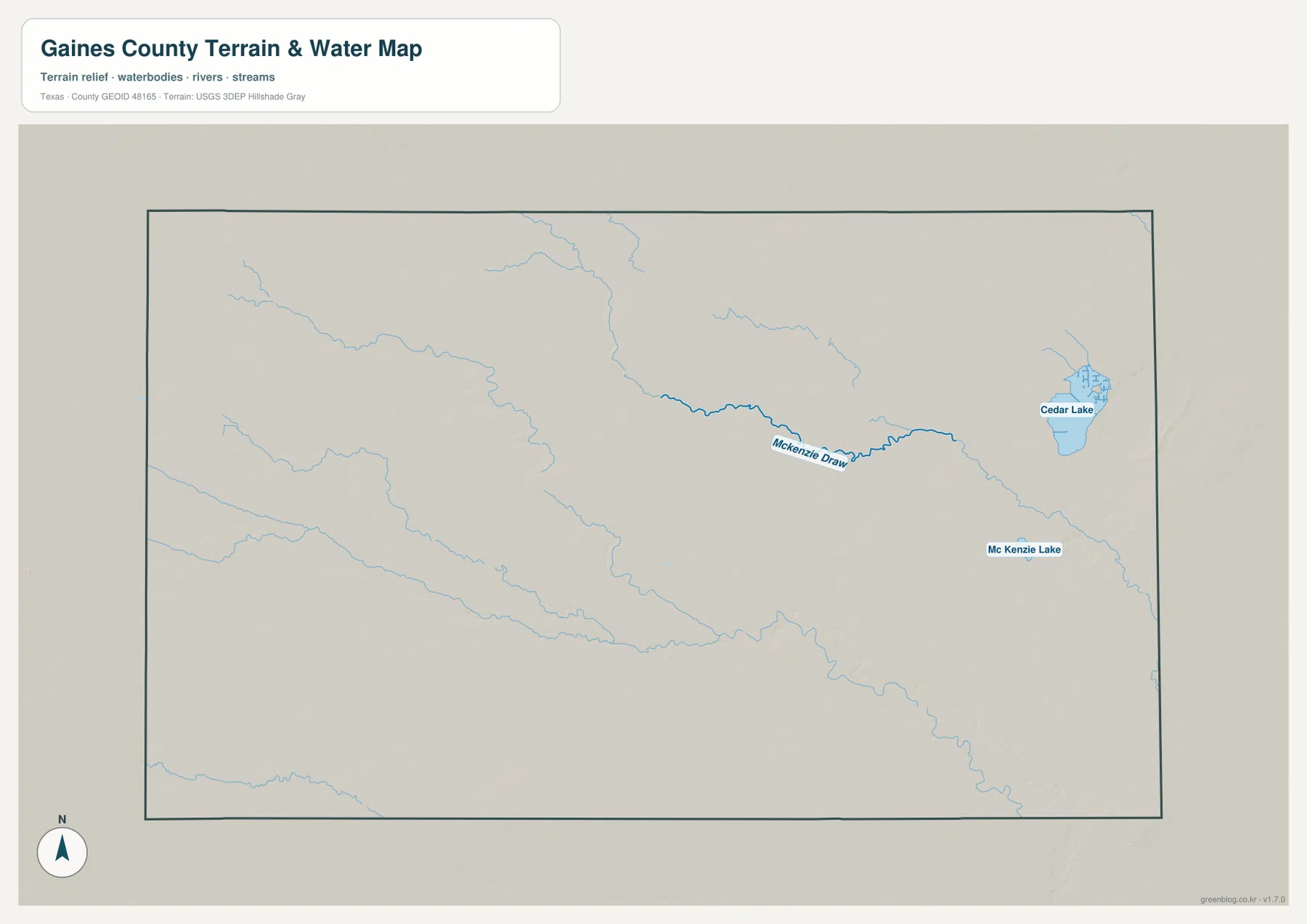
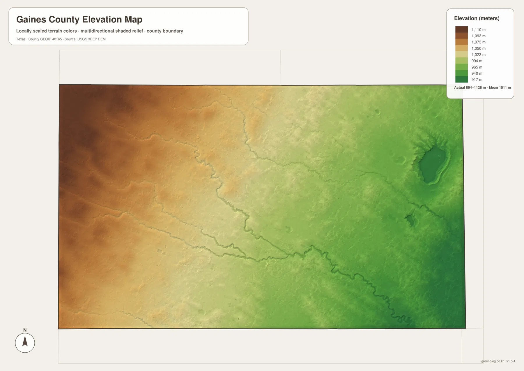
Download high-resolution A3 JPG maps of Gaines County, Texas from the ZIP box on this page, including the county, city, water, and elevation views shown below. Seminole is the central road reference, Seagraves sits near the northern edge, and Loop is separated farther east in the north. Routes labeled 62 and 180 create a long east-west line through Seminole, while 214 and 385 provide the strongest north-south references. The water map is comparatively sparse but identifies McKenzie Draw, Cedar Lake, and Mc Kenzie Lake, and the elevation map shows a pronounced decrease from high western ground to lower eastern terrain across an actual range of about 894 to 1,128 meters.
Gaines County is visually simple at first because its boundary is broad, its roads are fairly straight, and the major city labels are widely separated. The terrain layers add the detail that the road map lacks. Shallow drainage lines extend across the interior, Cedar Lake occupies a distinct basin in the east, and the elevation colors change steadily from brown in the west to green in the east. Using Seminole as a fixed point makes it easy to compare these transportation, water, and terrain differences without relying on generic descriptions of the wider High Plains region.
Table of Contents
Seminole at the County’s Main Road Crossing
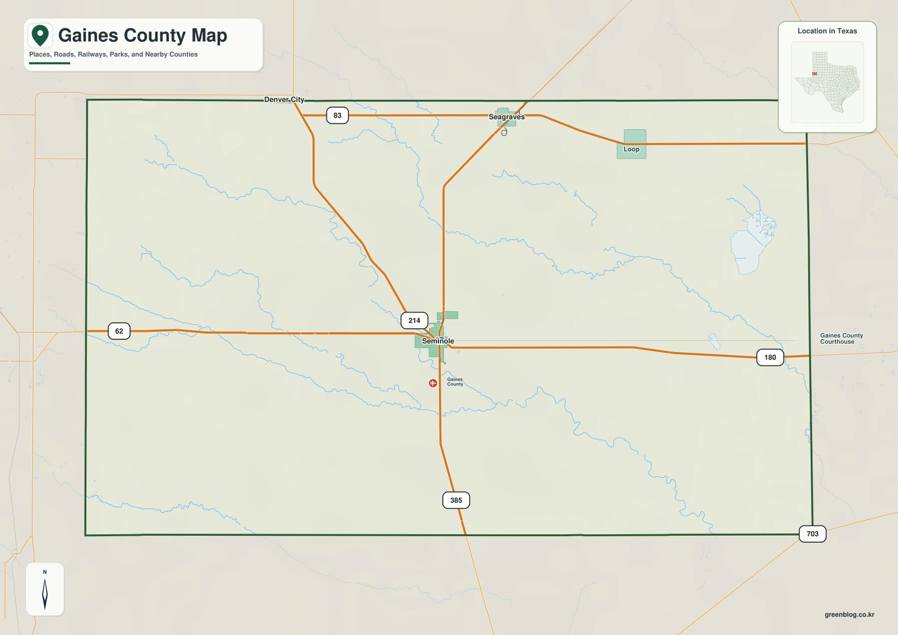
The general county map makes Seminole the most obvious place to begin. Route 62 approaches from the west and the route labeled 180 continues east, creating the strongest horizontal line across the county. Route 214 descends from the Seagraves area to Seminole, and the road labeled 385 continues south. These four route numbers provide a useful frame for locating nearly everything else on the map.
Seagraves is close to the northern boundary and connects southward toward Seminole along 214. A road labeled 83 appears to the west of Seagraves, while Loop lies farther east and is separated from the county’s two ranked cities. The long road segments and large gaps between city labels make the county’s scale easy to appreciate without turning those empty spaces into unsupported assumptions about land use.
Near the southeast boundary, Route 703 is labeled outside the main Seminole road junction, and the southern 385 corridor gives the lower half of the county a clear vertical reference. Thin blue drainage lines cross several of these roads but follow much less regular shapes. For travel orientation, the numbered routes are the best first layer; the water and elevation views then explain the natural features crossed by those roads.
A Two-City Index: Seminole and Seagraves
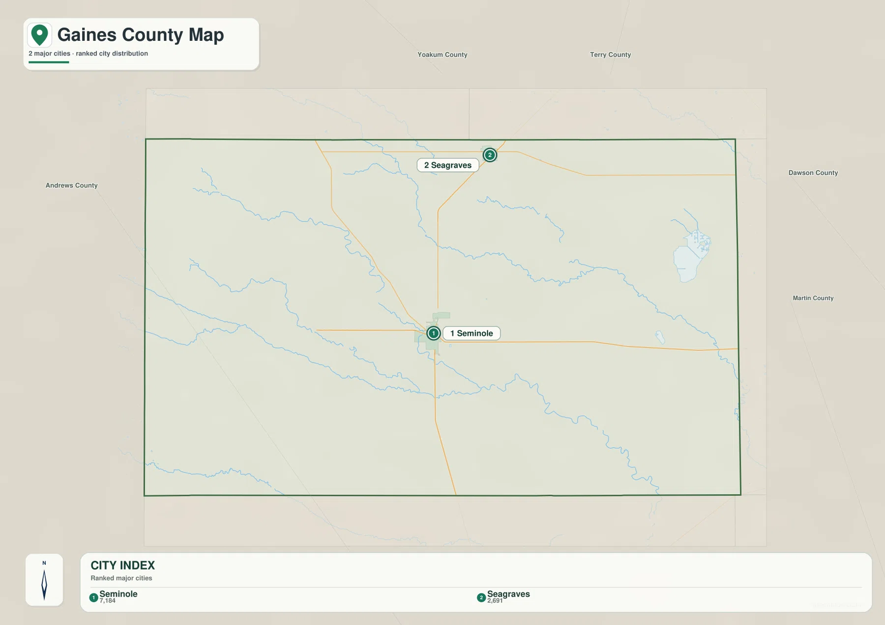
The city map highlights two major cities. Seminole is ranked first with a displayed value of 7,184, while Seagraves is second at 2,691. Seminole lies close to the middle of the county and Seagraves near the north. No connector-mile label is printed between them, so the graphic should be read for relative city size, direction, and spacing rather than as a precise distance chart.
The general map reinforces the same north-south relationship because Route 214 links the Seagraves area with Seminole. Loop is visible on the broader county map but is not part of this ranked city index. That distinction matters: the city view is not meant to list every community in Gaines County. It isolates the two highlighted centers so their locations are easier to compare without the extra road and stream detail.
Seminole also has the denser road junction, which makes its first-place city ranking easy to relate to the transportation map without making claims about local economic activity that the images do not show. Seagraves forms a separate northern reference. The broad area between and around the two cities becomes more informative when the water and elevation maps are added, because shallow drainage and gradual elevation change are visible even where few place labels appear.
McKenzie Draw, Cedar Lake, and the Eastern Water Features
McKenzie Draw is the clearest named channel on the supplied water map. It runs through the east-central part of the county in a winding line and connects visually with several thinner drainage features. It is not drawn like a broad permanent river, but its stronger line and label make it the best water reference for the interior eastern half.
Cedar Lake lies farther east and is the largest clearly labeled lake on the map. Small channels approach the basin from the north and northeast. Mc Kenzie Lake is a separate, much smaller feature southwest of Cedar Lake, so the similar names should not be treated as a single water body. Locating Cedar Lake first and then moving southwest toward Mc Kenzie Lake is the simplest way to distinguish them.
Several unnamed or lightly labeled drainage lines cross the western, central, and southern interior. Their long shallow curves are important because the elevation map shows many of the same routes as subtle low corridors. The water view is a location reference, not a flood-hazard, legal-boundary, depth, or navigation map, and the presence of a blue line does not establish year-round flow.
A Clear Elevation Drop from West to East
The elevation map lists an actual Gaines County range of about 894 to 1,128 meters and a mean near 1,011 meters. Dark brown and brown-orange colors occupy most of the west, showing the county’s highest broad terrain. The central area shifts through tan and yellow, and the east becomes increasingly green. This produces a strong west-to-east change even though the surface is not mountainous.
The transition contains numerous shallow cuts rather than one smooth slope. Drainage lines appear as slightly lower corridors reaching through the central and western uplands. In the east, the Cedar Lake basin forms a much more obvious low depression, while the McKenzie Draw corridor can also be traced as a lower path across the surrounding surface. Comparing the elevation and water maps is especially useful here because the two layers explain the same landscape from different viewpoints.
The difference between the mapped minimum and maximum exceeds 200 meters, yet most of that change is spread across a wide county rather than concentrated in steep mountain faces. The elevation colors are therefore useful for broad geographic comparison but should not be treated as survey-grade measurements for a parcel, road grade, construction project, or engineering design.
Using Seminole to Compare the Western Upland and Eastern Basin
Seminole is a useful dividing point for the county’s west-east terrain change. Following Route 62 west from the city leads into progressively higher colors on the elevation map, and the county map shows few large named water bodies in that direction. Following the route labeled 180 east instead moves toward lower terrain, the McKenzie Draw corridor, and eventually the Cedar Lake area.
North toward Seagraves, elevations remain relatively high near the central-western side before dropping again toward the northeast. Loop sits in that northern-eastern part of the county, separated from the Seminole–Seagraves city pair. The city map may look sparse, but the elevation surface shows that the land between those places is not uniform: broad slopes and shallow drainage lines create a gradual but consistent physical change across the county.
Choosing the Gaines County Map That Fits the Question
Use the general county map when you need Seminole, Seagraves, Loop, the route labels 62, 180, 214, and 385, or the county boundary in one view. The city map is the quickest way to compare the two ranked communities. Choose the water map for McKenzie Draw, Cedar Lake, Mc Kenzie Lake, and the shallow drainage network, and use the elevation view when the main question is how the high western surface grades into lower eastern terrain.
The WebP images are convenient for viewing on the page, while the ZIP below contains the matching high-resolution A3 JPG originals for printing and larger displays. The archive includes the county, city, water, and elevation maps shown here, so you can keep the full set or use only the file needed for classroom work, a presentation, local reference, or a personal map collection.
Frequently Asked Questions
How are Seminole and Seagraves positioned on the Gaines County maps?
Seminole lies near the center of the county and Seagraves near the northern boundary. Route 214 connects their general locations, and the city map ranks Seminole first and Seagraves second.
Which water features are easiest to identify?
McKenzie Draw is the clearest named channel in the east-central interior, while Cedar Lake is the largest labeled lake in the east. Mc Kenzie Lake is a separate smaller water body southwest of Cedar Lake.
Where are the higher and lower parts of Gaines County?
The elevation map shows the highest broad terrain in the west and progressively lower ground toward the east. Its actual mapped range is about 894 to 1,128 meters, with a mean near 1,011 meters.
Sources and Reference Data
USGS The National Map Viewer — Official map service for roads, terrain, hydrography, and other geographic layers.
USGS National Hydrography — Official reference for rivers, streams, lakes, and hydrographic data.
USGS 3D Elevation Program — U.S. Geological Survey program for elevation and terrain data.
U.S. Census Bureau TIGER/Line Shapefiles — Official source for county boundaries, roads, and related base geography.
Map File Information
Download the Gaines County county map, city map, water map, and elevation map as high-resolution A3 JPG files. The ZIP contains the original map files shown on this page.
- File Type: JPG
Related Maps
- Andrews County Texas map
- Terry County Texas map
- Yoakum County Texas map
- Ward County Texas map
- Winkler County Texas map
Green Map creates custom-edited map images using open geographic data sources such as geoBoundaries, Natural Earth, OpenStreetMap, and government open data.
These maps are edited visual materials, not raw data files, and are provided for education, documents, presentations, and graphic reference.