This page uses Kermit as the main reference for a Winkler County Map, then follows the road network south toward Wink and east along the route 302 corridor. Download the high-resolution A3 JPG map ZIP from the box below when you need printable or editable files; it contains separate county-reference, ranked-city, terrain-and-water, and elevation maps.
Winkler County is unusually simple on the settlement map. Kermit and Wink are the only two ranked cities, and most of the county contains far fewer place labels than the urban areas. The existing article places the county within the Permian Basin oil-field landscape and notes the Monahans Sandhills direction near the southeast. The new map set adds a much clearer terrain story: elevation rises sharply toward the northeast and falls across the south and southwest, while the water layer contains only a few short, unnamed channels.
Table of Contents
Kermit is the road reference for routes 18, 115, and 302
Kermit is the easiest place to locate first on the county reference map. Route 18 passes through the city and continues south toward Wink. Route 302 provides the strongest east-west reference through the Kermit area, while route 115 heads northeast. Those three roads make Kermit the natural orientation point for the center and northern half of the county.
Wink lies southwest of Kermit and is easy to find by following the route 18 direction. It is shown as a much smaller built-up area, with fewer road and place labels around it. Monahans appears beyond the southern county boundary, and the existing article describes the southeastern side near Wink as the transition toward the Monahans Sandhills. That package-supported context is useful, but the map itself is strongest for showing the Kermit–Wink alignment and major route directions.
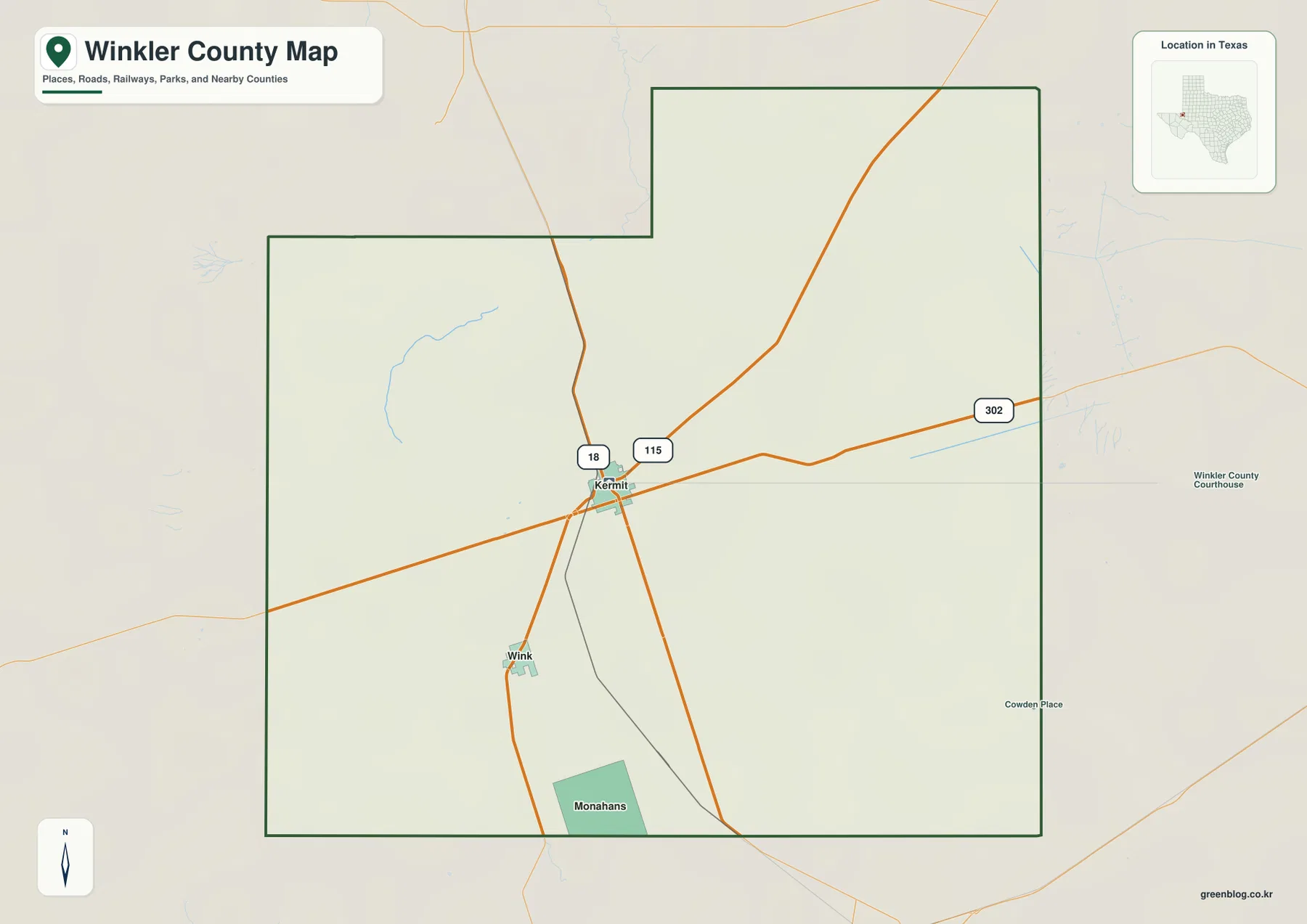
The county outline has a broad rectangular lower section and a northern extension that steps upward near the center. Kermit sits just below that extended northern area, which helps explain why several major routes spread outward from the city. Away from Kermit and Wink, the map becomes very sparse. Roads and terrain therefore become more useful orientation tools than settlement names across much of the county.
Kermit ranks first at 5,689, with Wink second at 1,373
The ranked-city view removes most secondary detail and highlights only Kermit and Wink. Kermit is number 1 in the north-central part of the county, while Wink is number 2 to the southwest. The simplified layer makes their spacing easier to understand than the full reference map and reinforces how strongly settlement is concentrated in just two places.
The CITY INDEX prints map values of 5,689 for Kermit and 1,373 for Wink. These figures explain the ranking and relative symbol sizes used in the supplied graphic and should be treated as map values rather than guaranteed current population estimates. For geographic reading, the useful distinction is straightforward: Kermit is the dominant road and settlement center, while Wink provides the main southern and southwestern reference.
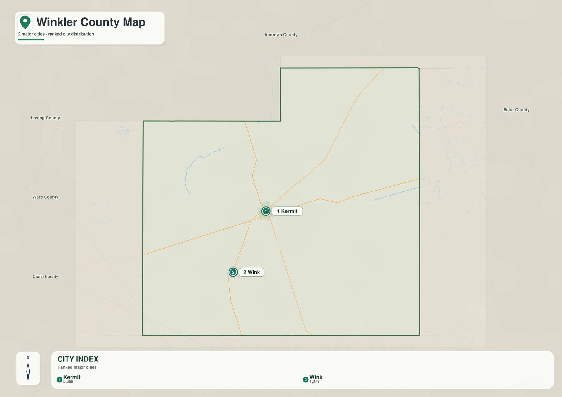
Neighboring county labels provide additional context. Andrews County is north, Ector County lies to the east, Loving County is northwest, Ward County is west, and Crane County appears southwest. That frame shows why Kermit works as a central road reference between several county directions, while Wink sits closer to the southern and southwestern side.
The water map is notable for how little named surface water appears
The terrain-and-water map does not label any major river, creek, or lake inside Winkler County. A short winding blue channel appears in the northwestern to west-central part of the county, and another short blue feature appears in the east-central area. Beyond those few marks, named surface-water features are absent from the supplied layer.
That absence matters because it limits what can be said responsibly from the package. An unlabeled blue line should not be assigned a creek or river name simply because a nearby regional feature is known from outside sources. This article therefore describes only the visible location and shape of the mapped channels and does not invent hydrologic names that are not printed on the image.
The northwestern channel curves through the interior for a short distance, while the east-central feature is straighter and more isolated. Neither forms a dominant countywide water corridor. Compared with the road and elevation maps, the water layer functions mainly as confirmation that surface-water features are sparse in the supplied graphic rather than as a detailed guide to named rivers and lakes.
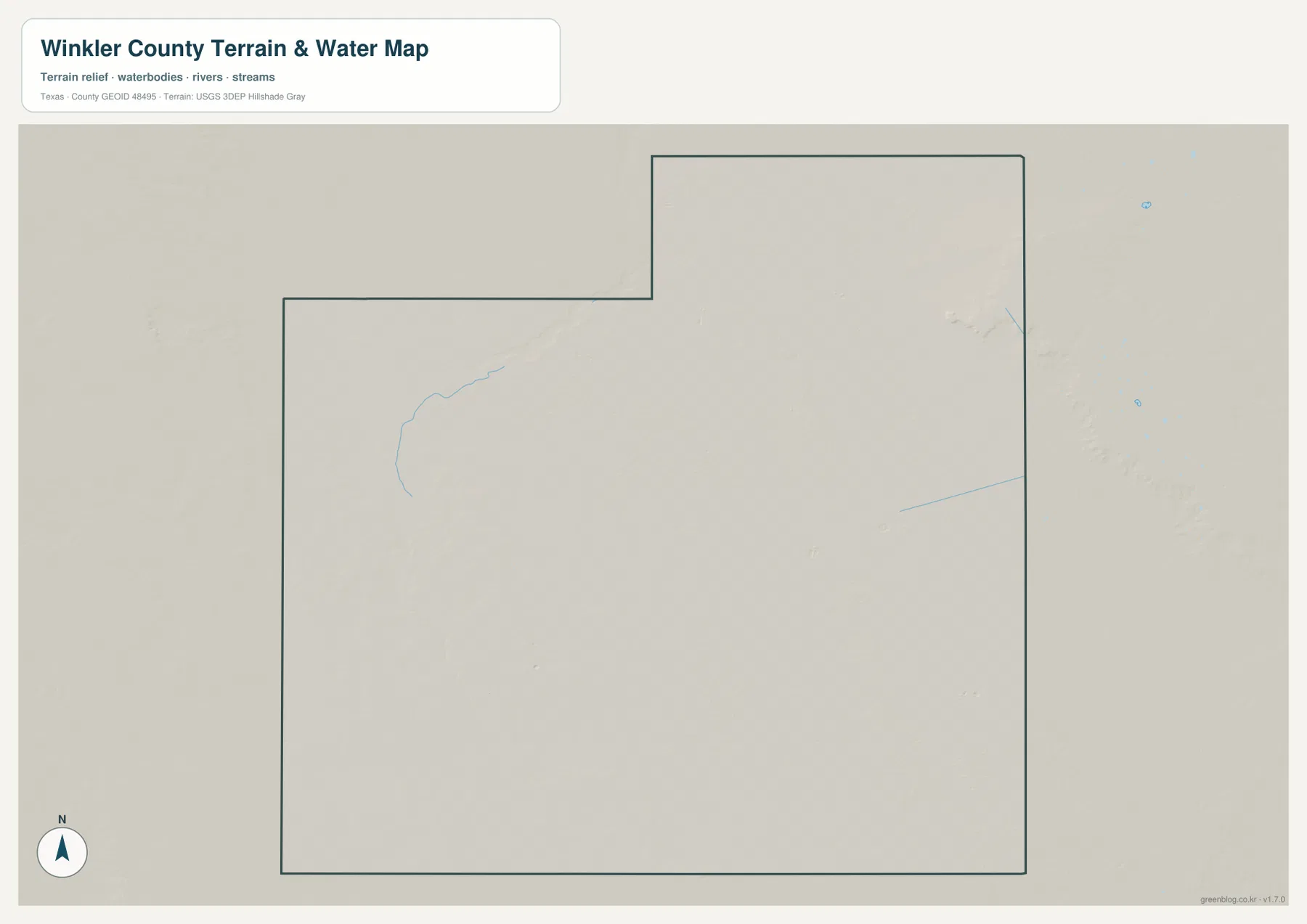
This layer is intended for geographic reference only. It does not establish flood risk, groundwater conditions, channel status, water depth, parcel boundaries, or water-management conditions. Those questions require current specialized data. For this page, the safest and most useful interpretation is simply that the supplied map shows very limited named surface water.
Elevation rises to 1,036 meters in the northeast and falls across the south
The elevation map reports an actual range of about 811 to 1,036 meters and a mean elevation of 889 meters. The darkest brown high terrain is concentrated in the northeastern corner, with a broad tan and orange zone extending westward from it. Green lower terrain covers much of the southern and southwestern half, producing a strong northeast-to-southwest contrast.
The northeastern high ground is not completely smooth. Its edge drops through a series of slopes and shallow cuts before reaching the lower central terrain. The middle of the county contains yellow-green transition zones, while the west-central side includes lower corridors that stand out against nearby higher ground. Kermit lies closer to this middle elevation band than to the highest northeastern area, and the terrain continues to fall toward the Wink and southern side.
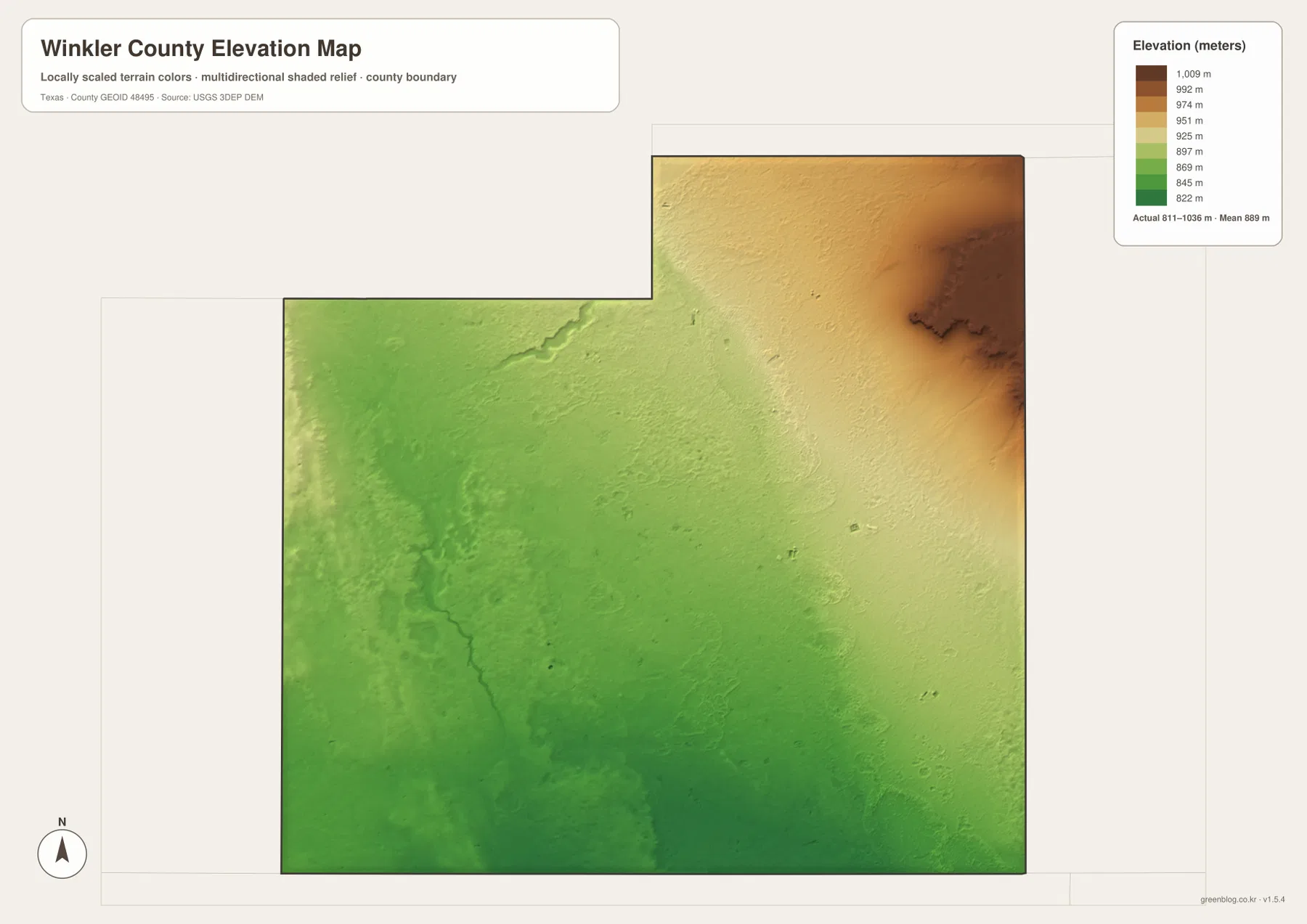
This countywide elevation surface is intended for broad terrain comparison rather than parcel surveying, engineering, or construction design. It is useful for seeing why the northeast stands higher, where the central transition zone begins, and how the county descends toward Wink and the southern boundary. Exact elevation at a specific site should be checked with detailed source data or a local survey.
Choose the layer by whether roads, two-city spacing, sparse water, or relief matters most
Use the county reference map when Kermit, Wink, routes 18, 115, 302, and the county boundary need to appear together. The ranked-city view is cleaner for comparing the two main communities. The terrain-and-water layer is most useful for confirming the very limited surface-water detail shown in this package, while the elevation map provides the clearest picture of the high northeast and lower southern half.
The downloadable ZIP contains four separate high-resolution A3 JPG files for Winkler County: county reference, ranked city, terrain and water, and elevation. You can inspect the lighter WebP versions in the article first and then use the larger JPG files for printing, classroom material, presentations, or an editable local-reference document.
Frequently Asked Questions
Where is Wink compared with Kermit?
Wink is southwest of Kermit on the supplied maps. Route 18 provides the clearest road reference between the two ranked communities.
Does the Winkler County water map show a major named river or lake?
No major named river or lake is labeled on the supplied terrain-and-water map. Only a few short blue channels are visible, so this article does not assign names to them.
What elevation range is shown for Winkler County?
The supplied elevation map states an actual range of about 811 to 1,036 meters and a mean elevation of 889 meters. The northeast is highest, while the south and southwest are lower.
Map File Information
The ZIP contains the four Winkler County maps in high-resolution A3 JPG format.
- Included Versions: County reference, ranked city, terrain and water, elevation
- Included Files: 4 A3 JPG maps
Related Maps
Sources and data references
Roads, settlement locations, and the Winkler County boundary can be cross-checked with the U.S. Census Bureau TIGER/Line Shapefiles. The few visible water channels can be compared with USGS National Hydrography, while terrain height data are available through the USGS 3D Elevation Program. City index values and the 811–1,036 meter elevation range described above are based on the Winkler County maps supplied in this package.
Green Map creates custom-edited map images using open geographic data sources such as geoBoundaries, Natural Earth, OpenStreetMap, and government open data.
These maps are edited visual materials, not raw data files, and are provided for education, documents, presentations, and graphic reference.