Iredell County is long from north to south, and the supplied maps make that shape useful rather than merely decorative. Statesville sits near the middle where major roads converge, Troutman lies farther south, and Mooresville occupies the more built-up southern end beside Lake Norman. Farther north, Harmony and Love Valley are separated by much larger stretches of lightly settled land. This page provides three map views of those differences: a county reference map with roads and places, a city-index map, and a terrain-and-water map. The same three maps are also available as high-resolution A3 JPG files in one ZIP download.
The three views are meant to be read together. The first map is best for county boundaries, road numbers, and town locations. The city map strips away much of that detail so the north-south settlement pattern is easier to compare. The water map then changes the emphasis again, bringing Lake Norman, the South Yadkin River, Rocky Creek, Hunting Creek, and numerous smaller streams into the foreground. Together they give a practical picture of where places sit and what lies around them without pretending to replace parcel, flood, navigation, or survey mapping.
Table of Contents
Statesville is the road-centered reference point
On the county map, Statesville is the clearest starting point. I‑40 crosses the central part of the county from west to east, while I‑77 runs north-south through the Statesville area and continues toward Troutman and Mooresville. The intersection of those two large corridors makes Statesville visually distinct even before the city label is read. For someone trying to orient a trip, locate a town, or understand why the county has more than one developed center, those two interstates provide an immediate framework.
The map also shows route numbers 21, 70, 64, 115, 90, 901, 152, and 3. Rather than treating every shield as an isolated fact, it is more helpful to notice how the roads change across the county. Around Statesville the network branches in several directions. South of the city, the I‑77 corridor continues through Troutman toward Mooresville, where local roads become denser. In the northern half, places such as Love Valley and Harmony are farther apart and the road pattern is more open.
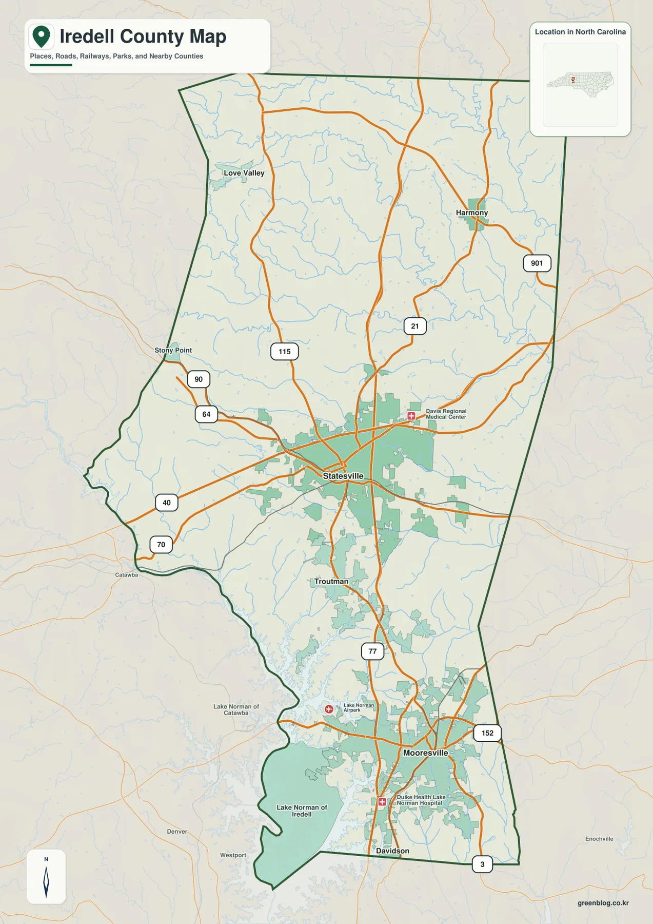
The county outline is also worth noticing. Its western side bends inward and outward rather than following one simple straight line, and the southern end narrows around the Lake Norman area. Stony Point is labeled on the western side, Love Valley appears in the upper west, and Harmony is in the upper east. Mooresville lies near the southern end, with Davidson labeled close to the bottom edge of the reference map. These place names make the county’s elongated shape much easier to understand than an outline alone would.
Two medical references are visible as well: Davis Regional Medical Center near Statesville and Duke Health Lake Norman Hospital near Mooresville. Lake Norman Airpark is marked in the southern portion. They are not the main subject of the map, but such landmarks can help readers connect the road network with recognizable local destinations. For general orientation, however, the county boundary, Statesville, Mooresville, I‑40, I‑77, and Lake Norman remain the strongest anchors.
The city index reveals a strong north-south contrast
The city map ranks five places shown within the supplied city index. Mooresville is number 1 with 52,381 listed on the graphic, Statesville is number 2 with 29,894, Troutman is number 3 with 3,995, Harmony is number 4 with 967, and Love Valley is number 5 with 159. Those figures are presented here exactly as they appear in the supplied map index; the map itself does not identify them as a newly verified census count for the date of this article.
Location matters more than the ranking by itself. Mooresville occupies the southern developed area, Statesville sits near the middle, and Troutman falls between them along the north-south corridor. Harmony and Love Valley are much farther north, one toward the east and one toward the west. Reading the map from top to bottom therefore produces a clear sequence: two small northern places, a central county seat and road hub, then a chain of southern communities leading toward the Lake Norman area.
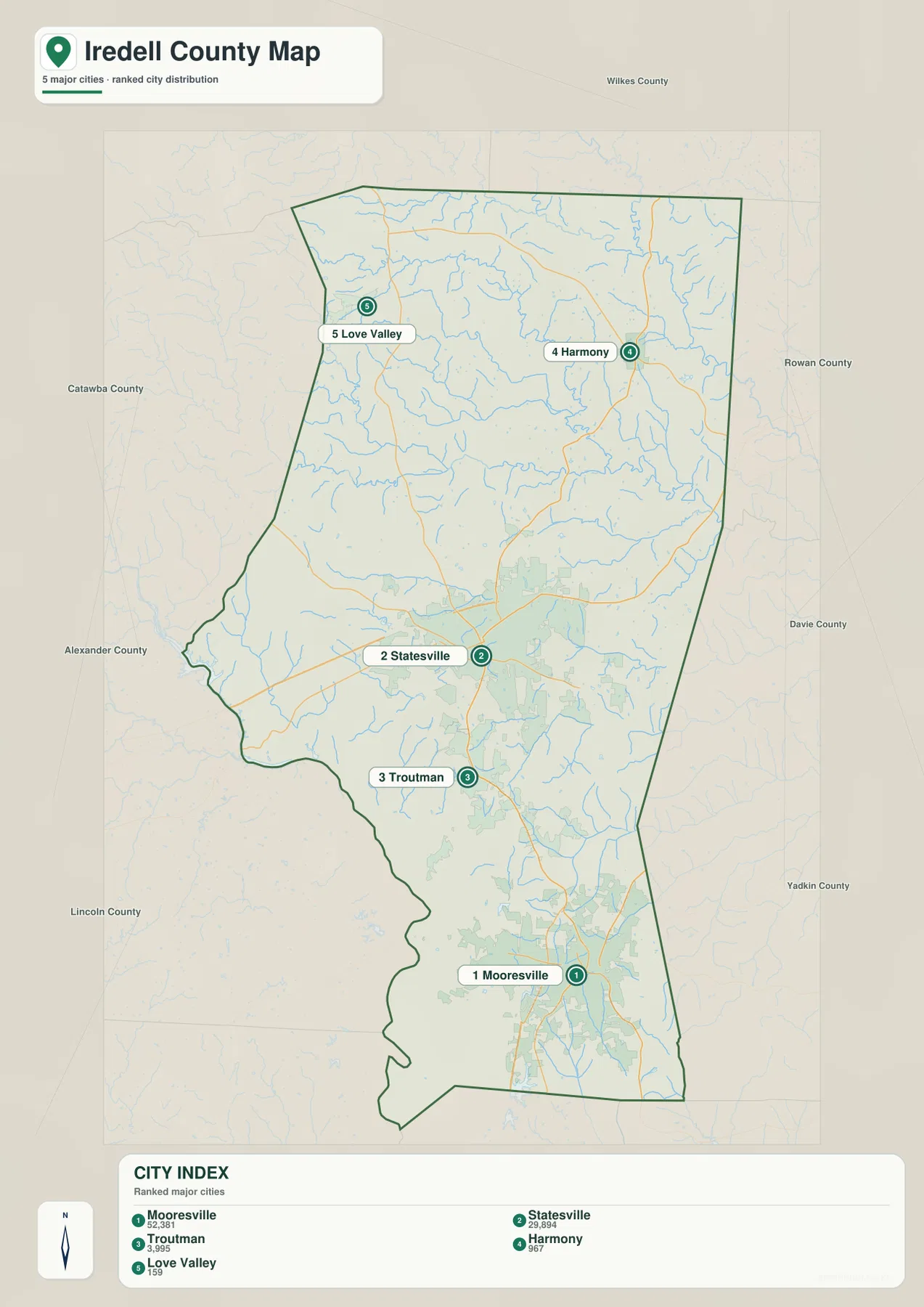
The city map also labels neighboring counties around the outside. Wilkes County appears to the north; Rowan, Davie, and Yadkin are shown along the eastern side; and Catawba, Alexander, and Lincoln appear to the west. Those labels are useful when the goal is to understand where Iredell sits relative to nearby county maps. They also make it easier to see why the northern end, the Statesville area, and the Lake Norman end should not be treated as interchangeable parts of one compact urban area.
For route planning, the city map works best as a first pass rather than a final navigation product. It quickly answers whether a place is in the northern, central, or southern portion of the county. After that, the county map provides the road detail needed to connect the locations. This two-step approach is especially useful for Troutman, which can be overlooked when readers jump directly from Statesville to Mooresville.
Lake Norman dominates the south while the South Yadkin crosses the upper county
The terrain-and-water map gives the southern end of Iredell County a completely different appearance. Lake Norman fills a large part of the southwest and south, with a highly irregular shoreline that sends narrow arms inland. On the reference map this same area is associated with Mooresville and the denser southern road pattern. On the water map, the lake becomes the primary landmark, making it much easier to understand why the county’s southern edge looks so different from the interior around Statesville.
Farther north, the South Yadkin River crosses the upper-middle portion of the county from west toward east. Rocky Creek descends toward it from the north-central area, and Hunting Creek is labeled in the northeast. Hill Creek and 3rd Creek appear farther south of the South Yadkin, among many smaller unnamed stream lines. The effect is not one single river corridor but a branching network of waterways spread through the county.
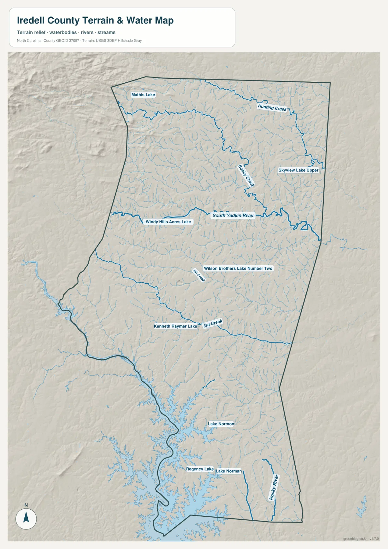
Several smaller named water bodies provide extra local reference points: Mathis Lake, Skyview Lake Upper, Windy Hills Acres Lake, Wilson Brothers Lake Number Two, Kenneth Raymer Lake, and Regency Lake are all labeled on the supplied image. Rocky River appears near the southeastern end. These names are useful when a reader already knows a local creek or lake and wants to place it inside the larger county outline.
The shaded terrain background is intended for broad visual comparison, not precise elevation measurement. Relief appears more textured along parts of the northwestern and western side, while the Lake Norman area is defined more strongly by branching water edges. The map source note identifies USGS 3DEP hillshade as part of the terrain background. That makes the image useful for seeing relative landform changes, but it should not be read as engineering-grade elevation, slope, or survey data.
Similarly, the blue stream and lake features should be treated as geographic reference information. This is not a flood-hazard map, a legal water-boundary product, or a navigation chart. A property decision, flood assessment, or on-water navigation task requires the appropriate specialized source. The value of this map is simpler: it shows how waterways are distributed across Iredell County and how Lake Norman relates to the county’s southern communities.
Reading roads, towns, and water as one county
The strongest way to use this set is to switch maps depending on the question. Suppose Statesville is the starting point. The county map shows it at the meeting of I‑40 and I‑77 and provides nearby route numbers. The city map shows that it is centrally placed between the small northern communities and the southern Mooresville area. The water map then adds the South Yadkin River to the north and Lake Norman to the south, giving the city a physical setting as well as a road setting.
Mooresville works the opposite way. Its urban road pattern is immediately visible on the county map, but the water map explains the southern geography more clearly by putting Lake Norman in the foreground. Troutman is useful as a midpoint between Mooresville and Statesville. Harmony and Love Valley, meanwhile, show how quickly the settlement pattern opens up in the northern half of the county. These differences are visible without needing to invent a single countywide description that fits every area.
The surrounding county labels add another layer. If the destination is toward Rowan, Davie, or Yadkin County, the eastern side of the city map provides the general direction. Catawba, Alexander, and Lincoln labels help with the western side, and Wilkes is shown north of Iredell. After locating the correct side of the county, switching to the reference map reveals the road network, while the water map is better for checking nearby streams, the South Yadkin, or Lake Norman.
What to check first on each map
Use the county reference map when the main question involves roads, town labels, the county outline, or the relative positions of Statesville and Mooresville. The city-index map is cleaner when you only need to compare the five featured settlements. Choose the terrain-and-water map when Lake Norman, the South Yadkin River, named creeks, or general relief is the priority. For printing or use in a separate document, the downloadable JPG files provide the higher-resolution version of each map shown on this page.
The archive contains only the map types actually supplied for this county. It does not add a separate elevation map, land-cover map, parcel map, or flood map. Keeping the download matched to the page prevents a reader from expecting a fourth product that is not present in the source package.
Frequently Asked Questions
Where are Statesville and Mooresville located within Iredell County?
Statesville is near the central part of the county where I‑40 and I‑77 converge, while Mooresville is much farther south beside the Lake Norman area. Troutman lies between them along the north-south corridor.
Which major waterways are visible besides Lake Norman?
The South Yadkin River is prominently labeled across the upper-middle county. Rocky Creek and Hunting Creek are shown to its north, while Hill Creek, 3rd Creek, Rocky River, and several named small lakes provide additional reference points.
What is included in the downloadable Iredell County ZIP?
The ZIP contains three high-resolution JPG files: the county road-and-place reference map, the city-index map, and the terrain-and-water map. Those are the same three map types previewed in the article.
Sources and Reference Data
- Iredell County – About Iredell County
- U.S. Census Bureau TIGER/Line Shapefiles
- USGS National Hydrography
- USGS 3D Elevation Program
Map File Information
The download contains the three Iredell County maps provided on this page as high-resolution A3 JPG files in one ZIP archive.
- Included Files: county reference map JPG, city-index map JPG, terrain-and-water map JPG
- File Type: one ZIP containing three JPG images
Related Maps
Green Map creates custom-edited map images using open geographic data sources such as geoBoundaries, Natural Earth, OpenStreetMap, and government open data.
These maps are edited visual materials, not raw data files, and are provided for education, documents, presentations, and graphic reference.