Dallas County sits in central Iowa, where the western edge of the Des Moines metropolitan area meets a broader landscape of smaller towns, river valleys, and agricultural countryside. Waukee and Clive stand out on the eastern side of the county, while Adel lies farther inland and Perry anchors the north. The road map also makes several major routes easy to recognize: Interstate 80 crosses the southeast, Iowa 141 serves the northern and northeastern side, Iowa 44 runs across the middle, and Iowa 169 passes through the Adel area on a north–south line. This page uses the supplied county, city, water, and elevation maps to explain how those places fit together. High-resolution JPG versions of the same map set are available in the download ZIP near the end of the article.
The county becomes easier to understand once the roads are compared with the rivers. North Raccoon River appears in the northwest, Middle Raccoon River reaches the southwest, and South Raccoon River crosses the southern part of the county before the Raccoon River continues toward the southeast. Des Moines River is visible near the northeastern side. The elevation sheet shows that these river corridors occupy lower ground, while the uplands between them rise noticeably higher. Rather than treating Dallas County as one flat block, the maps show a county divided by several long valleys, with dense suburban development concentrated on the east and more open land extending toward the west and northwest.
Table of Contents
Using Waukee, Adel, and Perry to orient the road map
Three places provide especially useful reference points on the general county map. Waukee is easy to find near the eastern side, close to West Des Moines and the Interstate 80 corridor. Adel lies southwest of the county’s middle and works well as an inland reference point because several important roads pass nearby. Perry is much farther north and is shown as a sizable urban area near the northern edge. Once those three locations are fixed, Dallas Center, Redfield, De Soto, Van Meter, Grimes, Woodward, and other labels become much easier to place without scanning the entire county at once.
Interstate 80 is the clearest long-distance route in the southeast and helps explain the relationship between Waukee, West Des Moines, and the southern edge of the county. Iowa 141 connects Perry with Woodward and Granger, while Iowa 44 crosses the middle through the Dallas Center area toward Grimes. Iowa 169 runs north–south through the Adel area and continues toward De Soto, and U.S. 6 links Redfield, Adel, and the eastern side. These routes are useful for geographic orientation, but the map is not a live navigation product. Construction, closures, travel times, and turn-by-turn directions should always be checked with a current road service.
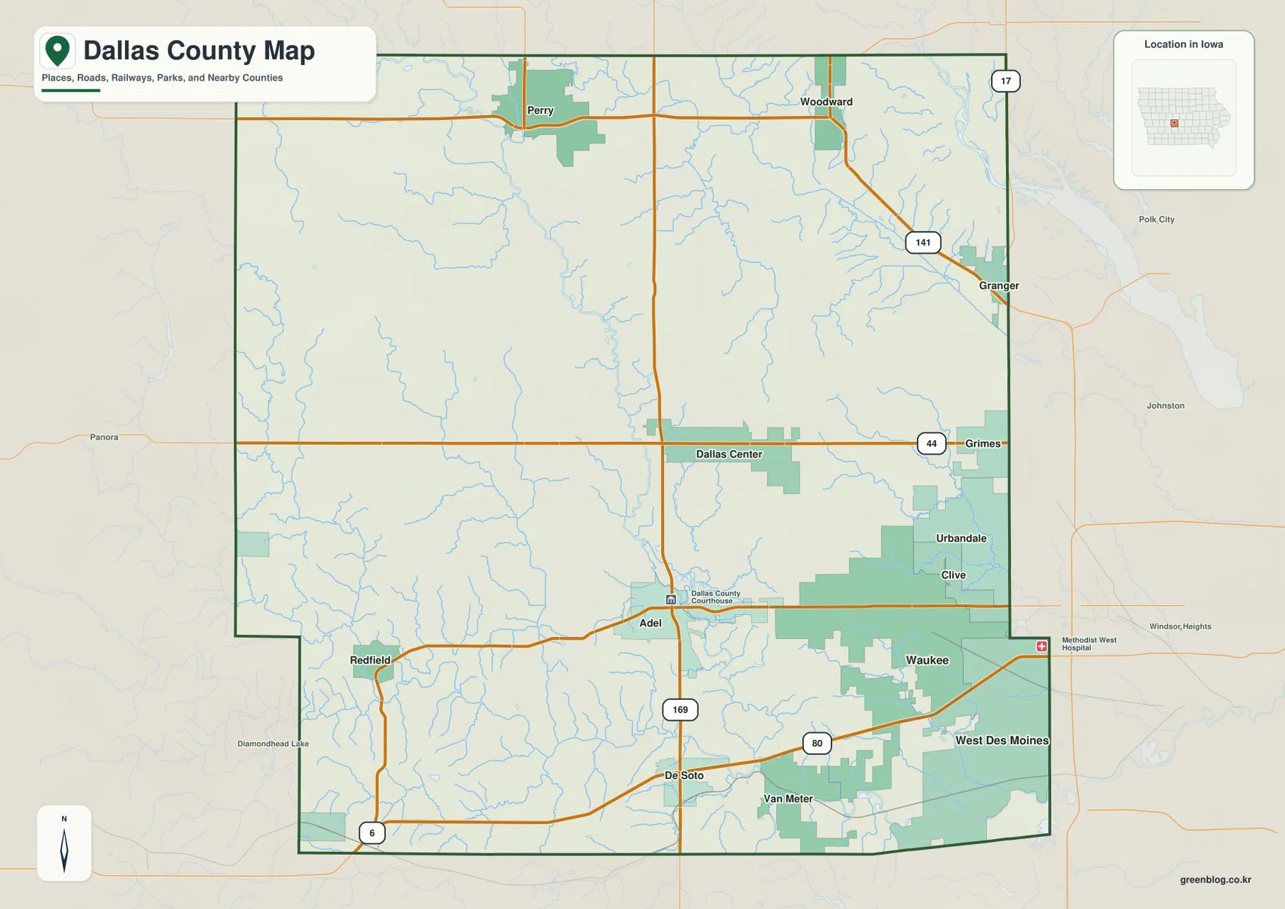
The eastern side is visually busier than the west. Waukee, Clive, Urbandale, Grimes, and the edge of West Des Moines form a closely spaced cluster near Polk County, while the western half has longer gaps between towns and roads. Perry forms a separate northern center, and Redfield marks the southwest more clearly than the denser suburban edge. That contrast is one of the most useful features of the general map: it shows that Dallas County includes both a fast-growing metropolitan fringe and a much more open interior landscape within the same county boundary.
A city pattern led by Waukee and Clive on the eastern side
The city index map simplifies the county by highlighting Waukee, Clive, Perry, Adel, Dallas Center, and Granger. Waukee is the largest value shown in the map legend, followed by Clive. Perry appears well to the north of the eastern suburban cluster, Adel occupies an interior position farther south, Dallas Center sits east of center, and Granger is close to the northeastern boundary. The distribution makes it clear that the county’s major places do not form a single central group. Instead, population is concentrated strongly toward the east, with Perry serving as a separate northern center and Adel providing an important inland reference point.
This simplified map is useful when road numbers would only distract from the basic geography. A reader can quickly see that Waukee and Clive are close to each other, while Perry is separated from them by a large stretch of county. Adel and Dallas Center help fill the gap between the eastern suburbs and the more open west, and Granger connects visually with the Iowa 141 corridor. After learning those positions, returning to the general map makes the road network much easier to follow because the city names already have a clear place in mind.
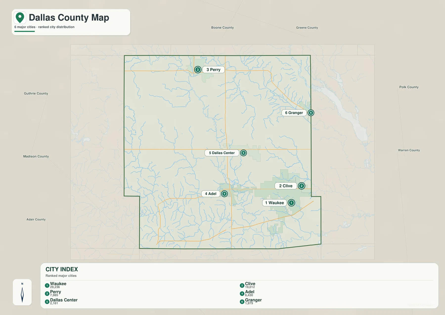
Neighboring county labels around the map provide additional context. Boone and Greene are shown to the north and northwest, Guthrie and Madison lie to the west and southwest, and Polk and Warren appear on the eastern and southeastern sides. Those labels are useful for placing Dallas County within central Iowa, although this page focuses on the geography inside Dallas County rather than giving a full guide to every neighboring county. For cross-county travel, a broader road map or current navigation service will provide the detail that a county-focused map intentionally leaves out.
North, Middle, and South Raccoon River valleys across the county
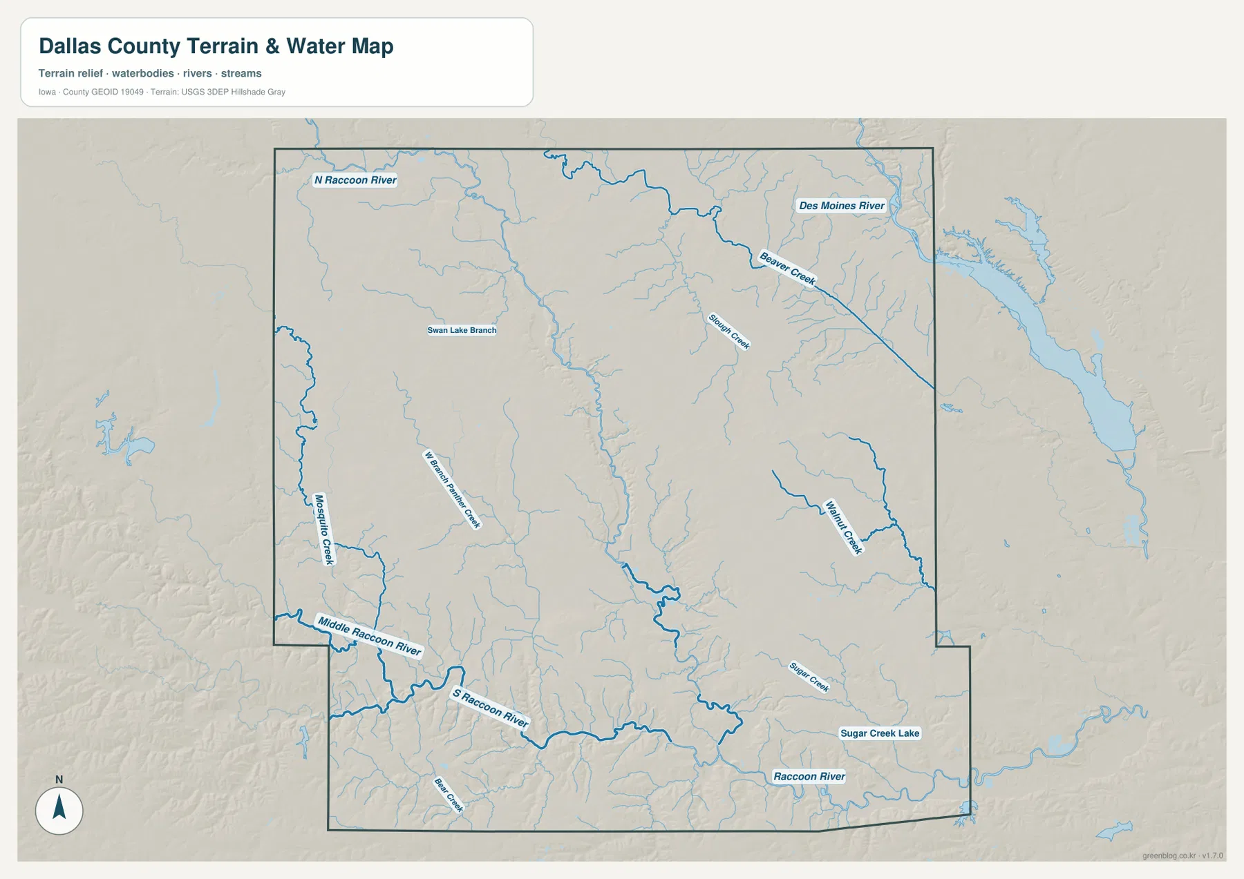
The terrain and water map reveals several distinct Raccoon River corridors. North Raccoon River is labeled in the northwest, Middle Raccoon River enters the southwest, and South Raccoon River runs through the southern portion of Dallas County. Farther southeast, the main Raccoon River continues as a broad watercourse. The repeated river name can look confusing at first, but the directional labels make the layout manageable: North Raccoon belongs to the northern side, while Middle and South Raccoon occupy the southwestern and southern parts of the county before the river system continues eastward.
Smaller streams add detail between the major valleys. Mosquito Creek, West Panther Creek, Walnut Creek, Sugar Creek, Beaver Creek, and Slough Creek are among the named waterways shown on the sheet, and Sugar Creek Lake appears in the southeast. These tributaries matter because they explain many of the narrow branches visible in the relief. A location that looks like open upland on the road map may be divided by several small drainage valleys on the water map. Following the named creeks into the larger rivers gives a clearer sense of how the landscape is organized without requiring any technical hydrology background.
Des Moines River is also visible near the northeastern side of the map, providing a second major river reference beyond the Raccoon system. Dallas County Conservation’s trail information separately lists the North Raccoon River Water Trail and the Middle/South Raccoon River Water Trail, and notes that the Middle and South Raccoon routes join below Redfield. That official information helps connect the map to real recreation corridors. Anyone planning to paddle or visit a river access should still check current water conditions, access status, and local rules rather than relying on a static map alone.
Elevation from 248 to 353 meters follows the river valleys
The elevation map gives Dallas County an actual mapped range of about 248 to 353 meters, with a mean elevation of 303 meters. The lowest green bands trace major river and creek valleys, while yellow, tan, and brown areas represent higher ground between those valleys. The southern part of the county is especially useful for comparing the water and elevation sheets because the Raccoon River system cuts a broad sequence of low corridors through surrounding uplands. The pattern is not a simple west-to-east slope; it is a network of lower valleys separated by higher rolling ground.
Lower terrain also stands out in the north and northeast. North Raccoon River forms a long green corridor, and the Des Moines River side of the county drops into another well-defined low area. Away from the river bottoms, the land rises gradually, with broad areas of higher terrain visible across the west and southwest. This contrast explains why the water map and elevation map work well together. The blue river lines identify the drainage routes, and the elevation colors show the lower land those routes occupy and the higher ground that separates one valley from the next.
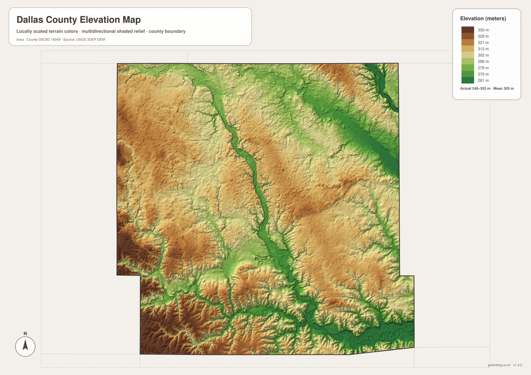
The colors are intended for county-scale comparison, not precise site measurement. A farm field, road crossing, or building lot may vary within a color band, and the map should not be used in place of surveying, engineering, or detailed flood analysis. For work that requires exact elevation values, the USGS 3D Elevation Program provides the underlying type of source data needed for closer analysis. Here, the elevation sheet is best used to understand the broad relationship between Dallas County’s towns, roads, and river valleys.
Adel links the inland road network with the Raccoon River landscape
Adel is a useful place to compare all four supplied maps because it sits away from the dense eastern edge yet remains connected to several important routes. Iowa 169 passes through the area on a north–south line, and U.S. 6 provides an east–west connection toward Redfield and the eastern side of the county. Nearby creeks and Raccoon River tributaries create lower corridors in the surrounding terrain. On the elevation map, those valleys break up the higher ground and show why the interior of Dallas County is more varied than the road map alone might suggest.
Other towns can be understood in the same way by pairing a road with a river or terrain feature. Perry belongs naturally with Iowa 141 and the northern Raccoon River area. Waukee is easiest to place beside Interstate 80 and the eastern metropolitan fringe. Dallas Center aligns with Iowa 44, while Redfield and De Soto help define the southwestern and southern sections. This approach turns a list of place names into a connected picture of the county and is especially helpful for readers who are not already familiar with central Iowa.
Connecting the river map with parks, trails, and conservation areas
Dallas County Conservation manages parks, natural areas, and land and water trails throughout the county. Its official trail pages include the North Raccoon River Water Trail and the Middle/South Raccoon River Water Trail, which makes the river network on the map relevant beyond simple geographic reference. Kuehn Conservation Area is another useful example: the county describes it as a large conservation property associated with the South Raccoon River landscape and offering trails and outdoor activities. Looking at these official resources after studying the map helps connect the broad river valleys with real places that residents and visitors can use.
Conditions at parks and rivers can change, so the static maps on this page should not be treated as an operating-status guide. Water levels, trail restrictions, access points, seasonal hunting rules, campground availability, and temporary closures need current confirmation from Dallas County Conservation or the relevant managing agency. The maps are best for learning where a place sits in the county and what kind of terrain surrounds it; current official pages are the right source for deciding whether and how to visit.
Choosing the most useful Dallas County map for your task
For a first look, start with Waukee, Adel, and Perry, then trace Interstate 80, Iowa 141, Iowa 44, and Iowa 169. That sequence quickly establishes the eastern suburbs, the interior, and the northern part of the county. If the goal is only to compare the major towns, the city index removes most secondary detail and makes the Waukee–Clive cluster, Perry, Adel, Dallas Center, and Granger easy to compare. Returning to the general map afterward provides the road detail needed to connect those places.
For rivers and terrain, identify North, Middle, and South Raccoon River first, then compare the same locations on the elevation sheet. The lowest green corridors generally follow the major waterways and their tributaries, while the land between them rises into broader uplands. This comparison is useful for classroom geography, local orientation, travel planning, and presentations because it shows why towns and roads occupy the positions they do. It also provides more context than looking at city labels or elevation colors in isolation.
The WebP maps in the article are sized for convenient browser viewing. For printing, offline reference, presentations, or lesson materials, use the high-resolution JPG files in the ZIP below. The archive contains separate files for the general county map, city map, terrain and water map, and elevation map. These maps are general reference products and should not replace legal boundary records, property surveys, live road information, flood determinations, or professional elevation measurements.
Frequently Asked Questions
Which map is best for comparing Waukee, Adel, and Perry?
The city index is the quickest choice when you only need relative positions. It shows Waukee and Clive on the eastern side, Adel farther inland, and Perry well to the north. If you also need highways and connecting routes, switch to the general county map and compare those places with Interstate 80, Iowa 141, Iowa 44, and Iowa 169.
How can I tell the Raccoon River branches apart?
North Raccoon River is labeled in the northwest, Middle Raccoon River enters the southwest, and South Raccoon River occupies the southern part of the county. The Raccoon River then continues toward the southeast. Using those broad positions first makes it easier to add smaller tributaries such as Walnut Creek, Sugar Creek, Beaver Creek, and Mosquito Creek.
What does the 248–353 meter elevation range show?
The range describes the mapped county-wide relief, not the exact elevation of every site. Lower green areas follow major river valleys and tributaries, while higher yellow and brown areas lie on the uplands between them. The map legend gives an overall range of about 248–353 meters and a mean elevation of 303 meters.
Map File Information
The ZIP contains high-resolution JPG versions of the Dallas County general map, city map, terrain and water map, and elevation map.
- Included Files: Use only the versions confirmed in the article and supplied images
- File Type: Use the confirmed download contents
- Intended Use: Printing, education, presentations, and map-based projects
Related Maps
Sources and reference links
These sources provide official county information and background data for boundaries, waterways, elevation, parks, and trails. Check the responsible agency for current operating conditions or rules before using a park, trail, or river access.
- Dallas County, Iowa official website
- Dallas County Conservation
- Dallas County land and water trails
- U.S. Census Bureau TIGER/Line Shapefiles
- USGS National Hydrography
- USGS 3D Elevation Program
These maps are intended for general geographic reference. Legal boundaries, ownership, road closures, flood status, and site-specific elevation should be confirmed with the appropriate current records and professional sources when those details affect a real-world decision.
Green Map creates custom-edited map images using open geographic data sources such as geoBoundaries, Natural Earth, OpenStreetMap, and government open data.
These maps are edited visual materials, not raw data files, and are provided for education, documents, presentations, and graphic reference.