A Macon County, North Carolina map becomes much easier to use once Franklin and Highlands are treated as separate mountain centers rather than two labels in one continuous urban area. Franklin sits near the middle of the county where several major roads and streams come together, while Highlands is tucked into the southeastern mountains close to the county edge. The three maps in this package focus on county roads and boundaries, the two main town centers, and the terrain-and-water network. High-resolution JPG versions of those maps are available in the download box near the end of the page.
The county’s shape also matters. Macon lies in far southwestern North Carolina, bordered by other mountain counties on the west, north, and east and by the state line along the south. Ridges and narrow valleys break up the interior, so a place that looks close on a flat outline may require a longer road route. Reading the roads together with the streams is especially useful here because many routes bend through the same lower corridors that carry the county’s rivers and creeks.
Table of Contents
Start with the county shape and its two town centers
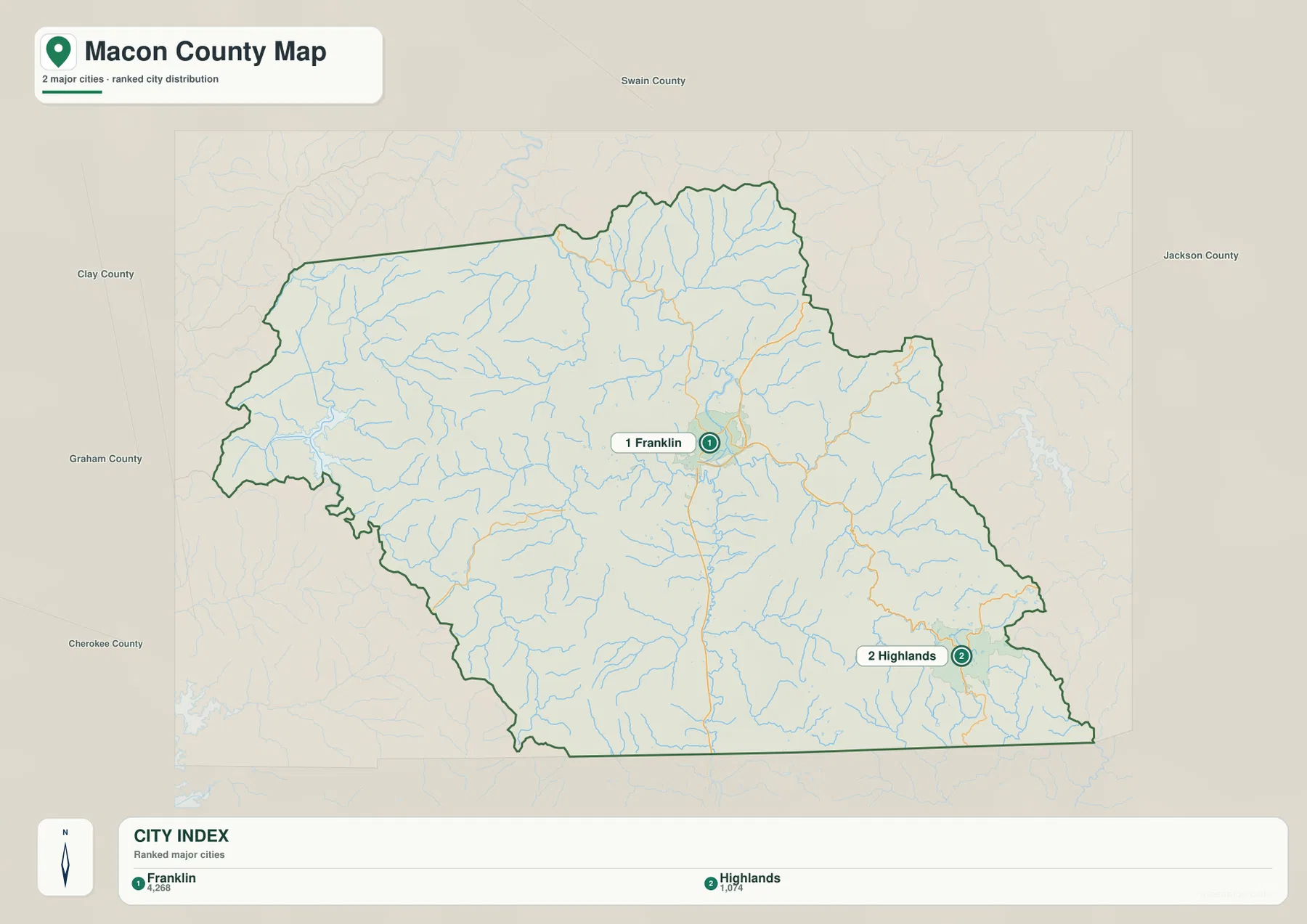
The city map places Franklin near the central part of Macon County and Highlands in the southeast. Around the outside, the map labels Cherokee, Clay, Graham, Swain, and Jackson counties, giving a clear picture of Macon’s position within the southwestern corner of the state. The southern edge reaches the North Carolina state line, while the northern and western sides are surrounded by other Appalachian mountain counties.
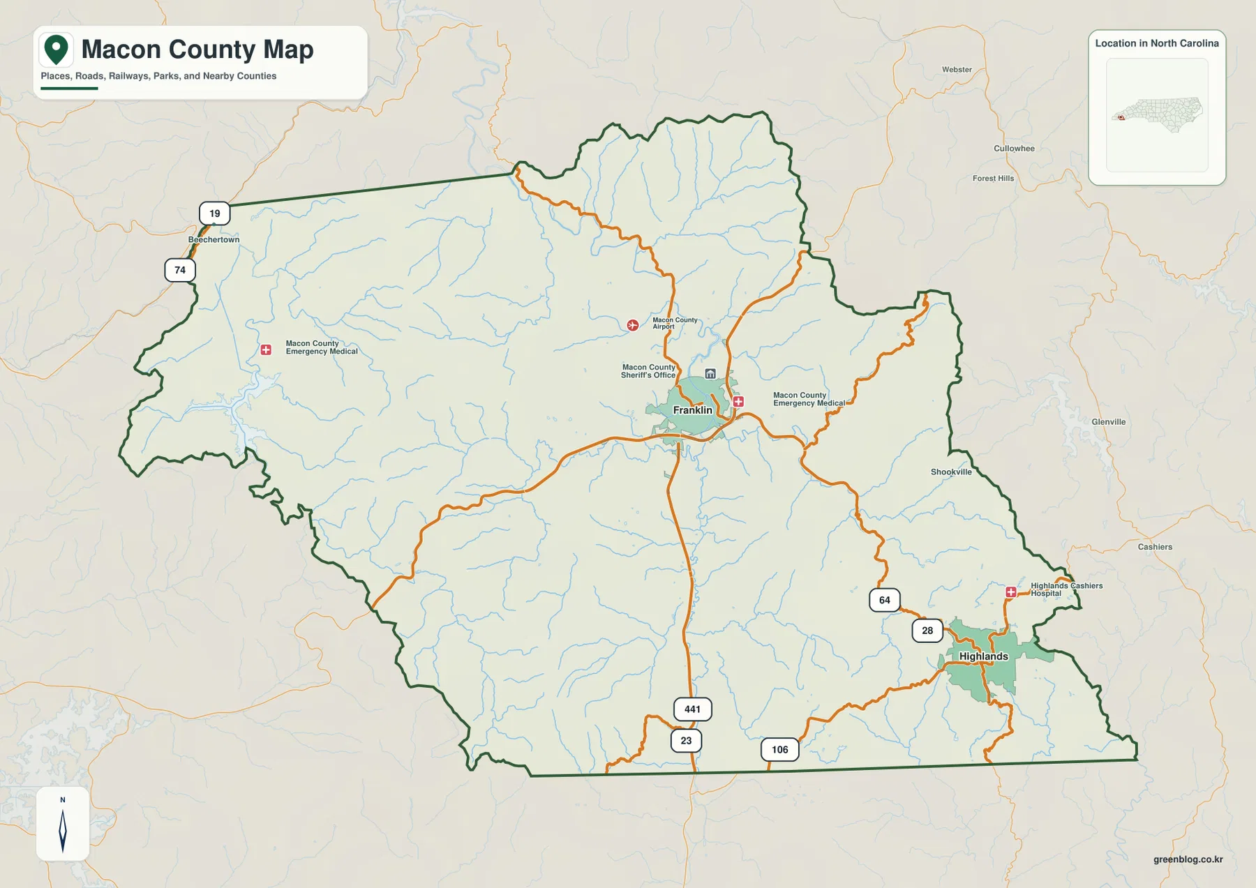
Franklin is the county seat and the most prominent built-up place on the general county map. Several civic and service locations appear around it, including the county airport, the sheriff’s office, and emergency medical facilities. Highlands is shown as a smaller, separate center in the southeastern part of the county, with its own road connections and a hospital label nearby. That separation is important: the map does not show one broad developed strip connecting the two towns. Instead, mountain terrain and branching waterways fill much of the space between them.
Roads converge at Franklin and spread into the mountain valleys
The road pattern makes Franklin’s central role easy to see. U.S. 23 and U.S. 441 run through the Franklin area on a north-south line and continue toward the southern state boundary. U.S. 64 approaches Franklin and then provides the principal mapped connection toward the southeastern side of the county. Around Highlands, the map also labels routes 28 and 106. Together these roads form the clearest travel framework on the general map.
They do not behave like roads across a flat county. Many segments curve along valleys or around higher ground, and the terrain map shows why. The county is packed with ridges separated by stream valleys, so a route may change direction several times even when its destination lies generally east, west, north, or south. This is particularly noticeable when comparing Franklin with Highlands. The two towns are separated not only by map distance but also by a rugged band of mountain terrain crossed by winding roads.
For a visitor using the map to plan a drive, the most useful sequence is to find Franklin or Highlands first, identify the numbered highway that leaves the town in the needed direction, and then check the terrain-and-water map for the valleys around that route. The package is not a turn-by-turn navigation product, but it provides enough geographic context to explain why roads follow the paths they do and why a short straight-line separation can feel much longer on the ground.
Franklin and Highlands occupy noticeably different settings
The simplified city map is useful because it removes most local detail and leaves the two primary town labels in their county positions. Franklin appears near the center, surrounded by a broad network of streams and roads. Highlands sits well to the southeast, close to the county boundary. The resulting pattern immediately shows that Macon County does not have a single compact urban center with suburbs radiating evenly in every direction.
The supporting material in the package describes Franklin as a center in the Little Tennessee River valley and Highlands as a higher-elevation southeastern center. The terrain image supports that distinction visually. Around Franklin, several waterways meet within a relatively broader valley setting. Near Highlands, tightly spaced ridges and narrow drainage lines dominate the background. That contrast is one of the most useful county-specific details in the set because it helps explain differences in road layout, settlement pattern, and travel between the two places without relying on abstract regional descriptions.
The Little Tennessee system ties together many of the valleys
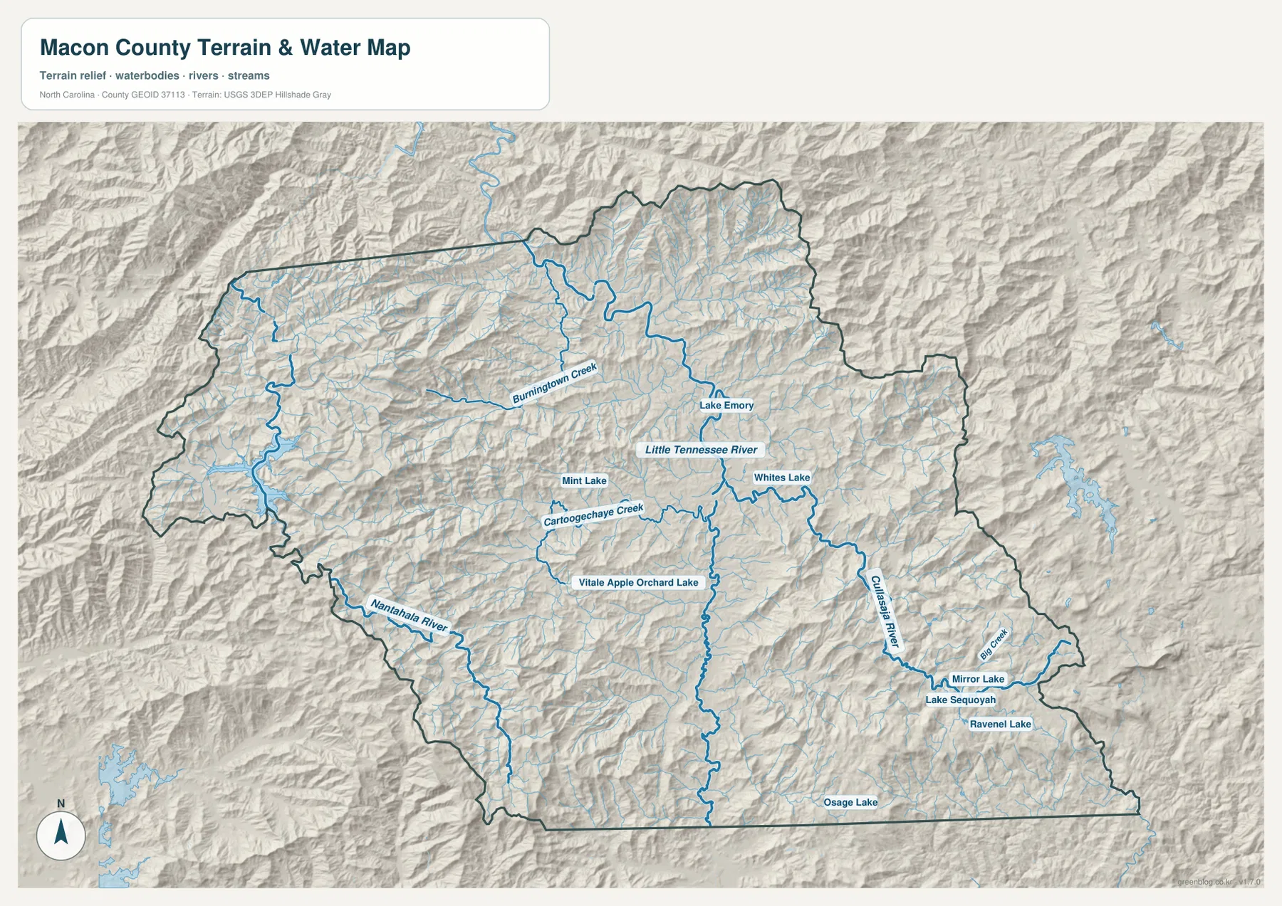
The terrain-and-water map adds the detail that is missing from a basic road map. The Little Tennessee River is the main named river across the central part of the county, and several important tributaries or neighboring river systems are labeled around it. Cartoogechaye Creek approaches the Franklin area from the west, Burningtown Creek appears to the northwest, the Cullasaja River occupies the eastern and southeastern side, and the Nantahala River is labeled in the southwest. Numerous smaller blue lines fill the mountain valleys between them.
These waterways are more than decorative background. Their branching pattern reveals the low corridors between the ridges. Roads often use the same valleys because they provide more practical routes through steep terrain. The Cullasaja River is especially useful when orienting the southeastern side of the county toward Highlands, while the Little Tennessee and its nearby tributaries help organize the Franklin side of the map. On the west, the Nantahala River gives another distinct reference in a much more mountainous area.
Several lakes are labeled as well. Lake Emory appears north of Franklin along the Little Tennessee system. Mint Lake and Whites Lake are marked closer to the central and eastern interior, and the Highlands area includes Mirror Lake, Lake Sequoyah, and Ravenel Lake. The map also labels Vitale Apple Orchard Lake and Osage Lake. These names make the water map useful for readers trying to identify a local water feature that may be hard to locate on a simplified county outline.
Shaded relief explains why straight-line distance can be misleading
The shaded relief is one of the most informative parts of the water map. Ridges run across nearly every part of Macon County, but their arrangement is not uniform. The Franklin area sits within a visibly broader valley zone, whereas the north, west, and southeast show repeated narrow ridges and deeply cut drainage lines. Around Highlands, the terrain appears especially compact and broken, reinforcing the idea that the town occupies a different physical setting from Franklin.
This matters whenever the map is used to compare neighboring places. A county boundary may look close to Franklin, yet the road toward that boundary can be indirect because it must stay within passable valleys. The same is true when looking toward Cherokee, Clay, Graham, Swain, or Jackson counties. Mountain divides do not stop at the county line, so regional travel follows a network of valleys and passes rather than the shortest line between two points.
The existing source material in the package also identifies Nantahala National Forest as a major part of Macon County’s landscape. This particular map set does not draw a separate national-forest boundary, so it should not be used to estimate the exact forest area. Still, the extensive mountain relief in the northern and western portions of the map helps explain why large undeveloped and forested mountain areas are such an important part of the county’s geography. Keeping that distinction clear prevents the road map from being mistaken for a land-cover or land-ownership map.
Which Macon County map should you use?
Use the general county map when you need boundaries, major roads, Franklin, Highlands, and a selection of local service locations on one page. It is the best first reference for understanding where the two towns sit and how the numbered highways connect them with the rest of the county. The city map is much simpler. It works well for presentations, school projects, or any situation where the relative position of Franklin and Highlands matters more than detailed roads and water features.
The terrain-and-water map is the most detailed choice for rivers, creeks, lakes, ridges, and valleys. It is useful when a reader wants to understand the Little Tennessee system, locate the Cullasaja or Nantahala rivers, or see why the road pattern bends through the mountains. Because the background includes shaded terrain, it also provides a better visual explanation of the contrast between the broader Franklin valley and the more rugged Highlands area.
The downloadable archive contains the same three map types as high-resolution JPG files. The WebP images on this page are intended for quick browser viewing, while the JPG versions are more suitable for saving, printing, or using in a larger document. No elevation-only or land-cover map is included in this package, so those map types are intentionally not described here.
Frequently Asked Questions
Where are Franklin and Highlands on the Macon County map?
Franklin is shown near the central part of the county where several major roads and streams meet. Highlands is in the southeastern mountains close to the county boundary. U.S. 64 provides the main mapped connection toward the Highlands side, while routes 28 and 106 are also labeled around Highlands.
Which rivers and creeks are labeled on the terrain-and-water map?
The map labels the Little Tennessee River, Cullasaja River, Nantahala River, Cartoogechaye Creek, Burningtown Creek, and Big Creek, along with many smaller unnamed tributaries. It also marks several lakes, including Lake Emory, Mirror Lake, Lake Sequoyah, and Ravenel Lake.
What files are included in the download ZIP?
The archive contains high-resolution JPG versions of the county map, city map, and terrain-and-water map shown on this page. The embedded WebP images are browser previews, while the downloadable JPG files are intended for saving, printing, or reuse in documents.
Sources and Reference Data
- NCpedia – Macon County
- U.S. Census Bureau TIGER/Line Shapefiles
- USGS National Hydrography
- USGS 3D Elevation Program
Map File Information
Download high-resolution A3 JPG files for Macon County boundaries and roads, town locations, and mountain waterways in one ZIP archive.
- Included Files: Use only the versions confirmed in the article and supplied images
- File Type: Use the confirmed download contents
- Intended Use: Printing, education, presentations, and map-based projects
Related Maps
Green Map creates custom-edited map images using open geographic data sources such as geoBoundaries, Natural Earth, OpenStreetMap, and government open data.
These maps are edited visual materials, not raw data files, and are provided for education, documents, presentations, and graphic reference.