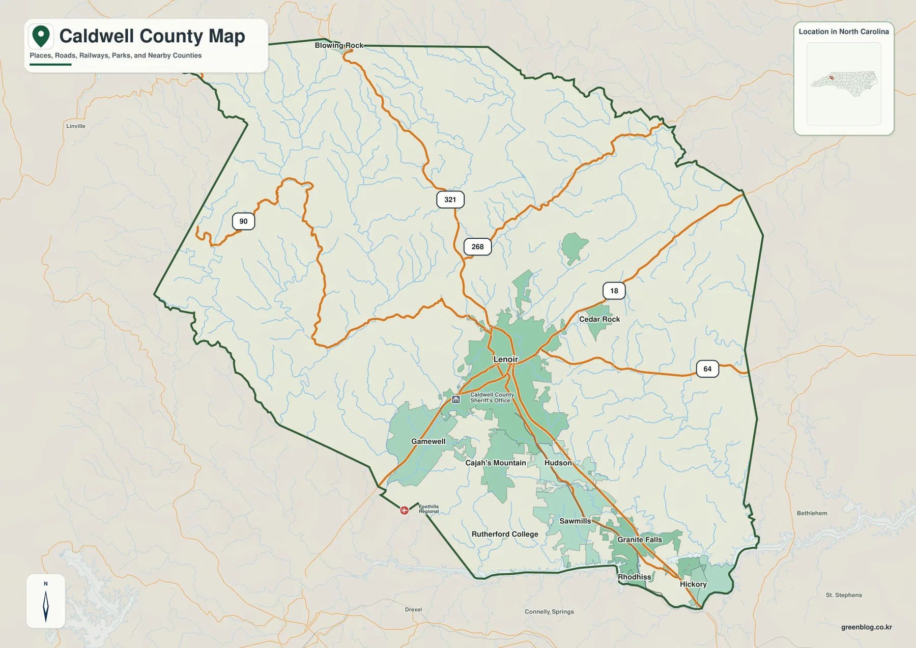
Caldwell County sits in western North Carolina where the settled foothill communities around Lenoir give way to much rougher mountain country to the north and west. This Caldwell County North Carolina Map page brings that contrast together with a county-and-road map, a ranked city distribution map, and a terrain-and-water map. The maps show how Lenoir connects southward toward Hudson, Sawmills, and Granite Falls, while rivers and smaller streams spread through the less densely settled mountain side of the county. A download box near the end of the article provides the same three subjects as high-resolution A3 JPG files in one ZIP archive for printing, classroom use, regional comparisons, or personal reference.
The county is easiest to understand when roads, settlements, and water are read together rather than as separate facts. NC 321 passes through Lenoir and continues toward the cluster of communities in the southern part of the county. NC 268, NC 18, NC 64, and NC 90 provide other routes toward the eastern and western edges. On the terrain map, Johns River and Yadkin River descend through the mountain interior, while Catawba River and Lake Hickory appear along the southeast side. The result is a county with a relatively concentrated southern settlement belt and a much broader northern landscape cut by ridges, valleys, and tributaries.
Table of Contents
Lenoir as the road hub between foothill towns and mountain routes
On the general county map, Lenoir stands slightly south of the county’s midpoint and functions as the clearest road reference. NC 321 comes down from the northern part of Caldwell County, passes through the Lenoir area, and continues south toward Hudson and Granite Falls. NC 268 crosses the interior north of Lenoir, while NC 18 approaches from the east and NC 64 runs across the eastern side of the county. Farther west, NC 90 follows a more winding route through mountain terrain. These roads do not form a uniform grid. Their spacing changes with the landscape, and the most concentrated network appears around Lenoir and the southern communities.
The county boundary also helps explain why the road pattern changes so much from one side to another. The north and northwest are dominated by steeper relief and numerous stream valleys, so routes tend to follow practical passages through the terrain rather than straight lines. The southern edge, by contrast, lies closer to the more continuously settled foothill area that extends toward Burke and Catawba counties. Labels outside the boundary identify Watauga, Wilkes, Alexander, Catawba, and Burke counties, making it easier to see Caldwell County as a transition zone between higher Blue Ridge country and lower, more urbanized foothill communities.
The southern settlement belt from Lenoir to Granite Falls
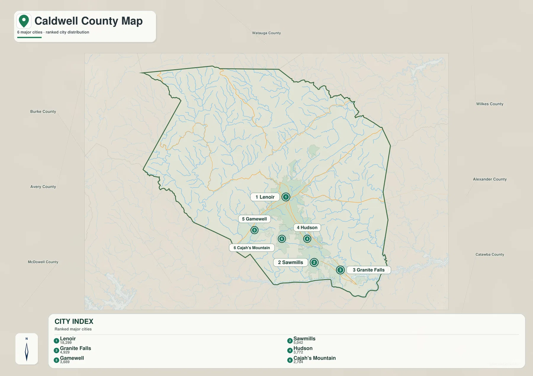
The ranked city map makes one of Caldwell County’s strongest geographic patterns immediately visible: the major settlements shown on the map are concentrated in the southern half. Lenoir is ranked first and sits at the northern end of this cluster. Sawmills is second, Granite Falls third, Hudson fourth, Gamewell fifth, and Cajah’s Mountain sixth. Their markers form a compact group compared with the large amount of county land north of Lenoir. The map therefore does more than rank places by population. It shows how the county’s principal communities occupy a relatively small part of the overall county area.
The relative positions are useful for orientation. Hudson lies south of Lenoir, while Sawmills sits farther south and Granite Falls is toward the southeast. Gamewell is southwest of Lenoir, and Cajah’s Mountain fills in the area between Gamewell and the communities farther east. Because the map removes much of the detail found on the general road map, the concentration is easy to see without tracing every highway. Anyone comparing local communities can quickly tell that Caldwell County does not have one isolated county seat surrounded by evenly spaced towns. Instead, several communities sit close together in a connected foothill belt while the mountain interior to the north remains much less represented by major settlement markers.
Johns River and Yadkin River through the mountain interior
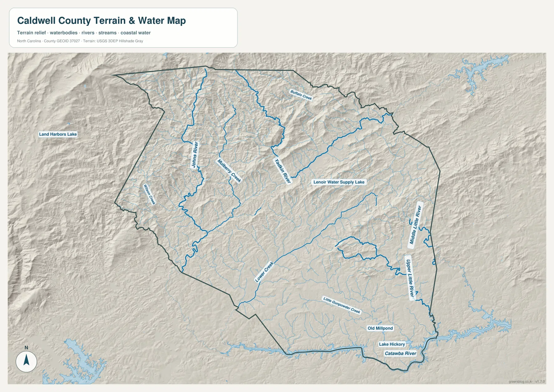
The terrain-and-water map shifts attention away from roads and towns and shows why the northern half of Caldwell County looks so different. Johns River runs through the northwestern interior and receives a network of smaller tributaries. Yadkin River appears farther east, also descending through a landscape of closely spaced ridges and valleys. Mulberry Creek and Buffalo Creek are labeled among the smaller waterways, while many additional tributaries are drawn in lighter blue. The shaded relief makes their relationship to the terrain clear: the streams twist between ridges rather than crossing a broad, flat plain.
Moving south, Lower Creek extends across the lower part of the county, and Middle Little River and Upper Little River appear near the eastern boundary. At the southeast corner, Catawba River and Lake Hickory form a larger water feature than the mountain streams upstream. Lenoir Water Supply Lake is labeled east of the central part of the county, and Old Millpond appears closer to the south. Taken together, these features show several different scales of water in one county, from small tributaries in steep uplands to larger river and reservoir waters near the southeastern edge.
Why northern Caldwell looks so different from the Lenoir–Granite Falls corridor
Comparing all three maps reveals a strong north-to-south contrast. The northern half occupies a large share of the county but contains few of the major settlement markers shown on the city map. It also has more rugged shaded relief and a denser web of streams. South of Lenoir, communities are closer together and the road network becomes more visually prominent. This is especially clear along the sequence from Lenoir through Hudson and Sawmills toward Granite Falls. The geographic contrast is therefore not simply a difference between “city” and “country.” It is a change from mountain terrain with dispersed access routes to a foothill settlement zone where roads and communities are much more concentrated.
This distinction is helpful when locating places that are not among the six ranked communities. In the north, a river name or numbered highway may be a better orientation point than the nearest town label. Johns River, Yadkin River, NC 321, and NC 268 provide useful references across that larger mountain area. In the south, the community names themselves are often enough to establish location because Lenoir, Hudson, Sawmills, Granite Falls, Gamewell, and Cajah’s Mountain are close enough to be compared directly. Along the east side, NC 18 and NC 64 can be paired with the Little River waterways, while Catawba River and Lake Hickory clearly mark the southeastern corner.
Choosing the best Caldwell County map for the question
The county-and-road map is the best starting point when the goal is to understand boundaries, highways, or travel direction. It shows how the main roads enter Lenoir, where the southern communities sit, and how the county fits beside its neighbors. The city map is simpler and better for comparing the relative positions of major communities. Because each selected place is ranked and labeled, it is especially useful for seeing the tight grouping in the southern half without the distraction of every road and stream.
The terrain-and-water map is more useful for questions about rivers, creeks, reservoirs, and the overall shape of the land. It should not be treated as a flood-risk map, legal water-boundary document, or navigation chart. The shaded relief is also a generalized terrain representation rather than survey-grade elevation measurement. Its value is visual orientation: it shows the rugged northern landscape, the channels followed by Johns River and Yadkin River, and the transition toward Catawba River and Lake Hickory in the southeast. Using the three maps together gives a fuller picture than asking one map to answer every question.
High-resolution files for printing and county comparisons
The maps displayed in the article are optimized for quick viewing on the web. The downloadable archive contains three high-resolution A3 JPG files matching the subjects shown here: a county boundary and road map, a ranked city distribution map, and a terrain-and-water map. Keeping them as separate files makes it easier to print only the map you need, place one map in a presentation, or compare Caldwell County with another county using the same subject. The ZIP is also useful when a larger image is needed than the on-page preview can provide.
Frequently Asked Questions
Why are the major communities clustered in southern Caldwell County?
The supplied city distribution map places Lenoir, Sawmills, Granite Falls, Hudson, Gamewell, and Cajah’s Mountain in the southern half of the county. The northern half is much more mountainous and is crossed by a dense network of streams, while the southern foothill area has a closer grouping of roads and communities. The map therefore shows a clear settlement concentration rather than an even countywide spread.
Which waterways are the best orientation points on the terrain map?
Johns River and Yadkin River are the strongest references for the northern mountain interior. Lower Creek helps with the southern side, while Middle Little River and Upper Little River are useful on the east. In the southeast, Catawba River and Lake Hickory provide an especially clear boundary-side reference. Smaller features such as Mulberry Creek, Buffalo Creek, and Lenoir Water Supply Lake add local detail.
What is included in the downloadable ZIP file?
The archive contains three high-resolution A3 JPG files: the county boundary-and-road map, the major city distribution map, and the terrain-and-water map. They match the three map subjects shown in the article and are intended for users who need a larger file for printing, presentations, classroom material, or side-by-side county comparisons.
Sources and reference data
- Caldwell County official history and geography information
- U.S. Census Bureau TIGER/Line boundary and road data
- USGS National Hydrography water data
- USGS 3D Elevation Program terrain and elevation data
Map File Information
Download the Caldwell County boundary-and-road map, city distribution map, and terrain-and-water map as high-resolution A3 JPG files.
- Included Files: Use only the versions confirmed in the article and supplied images
- File Type: Use the confirmed download contents
- Intended Use: Printing, education, presentations, and map-based projects
Related Maps
Green Map creates custom-edited map images using open geographic data sources such as geoBoundaries, Natural Earth, OpenStreetMap, and government open data.
These maps are edited visual materials, not raw data files, and are provided for education, documents, presentations, and graphic reference.