Carteret County is easier to understand when you begin with the water rather than with a single town. Beaufort, the county seat, and Morehead City sit along the mainland waterfront, while Bogue Sound separates much of that mainland from the long barrier island of Bogue Banks. Newport lies farther inland to the west, and communities such as Atlantic Beach, Pine Knoll Shores, and Emerald Isle occupy a very different coastal setting. The county also stretches far to the east, where narrow landforms, bays, sounds, and offshore islands make its outline much more complicated than a typical inland county.
This page includes a county map for boundaries, roads, and surrounding places; a city map for comparing the main population centers shown in the package; and a terrain-and-water map that gives the coastline, rivers, bays, and larger sounds more room. The map images can be viewed directly in the article, and the download box below provides the matching three high-resolution JPG files in one ZIP archive. That makes it possible to use a quick web preview first and then switch to the larger files for printing, classroom work, presentations, or closer geographic comparison.
Table of Contents
Start with the mainland, Bogue Sound, and the barrier islands
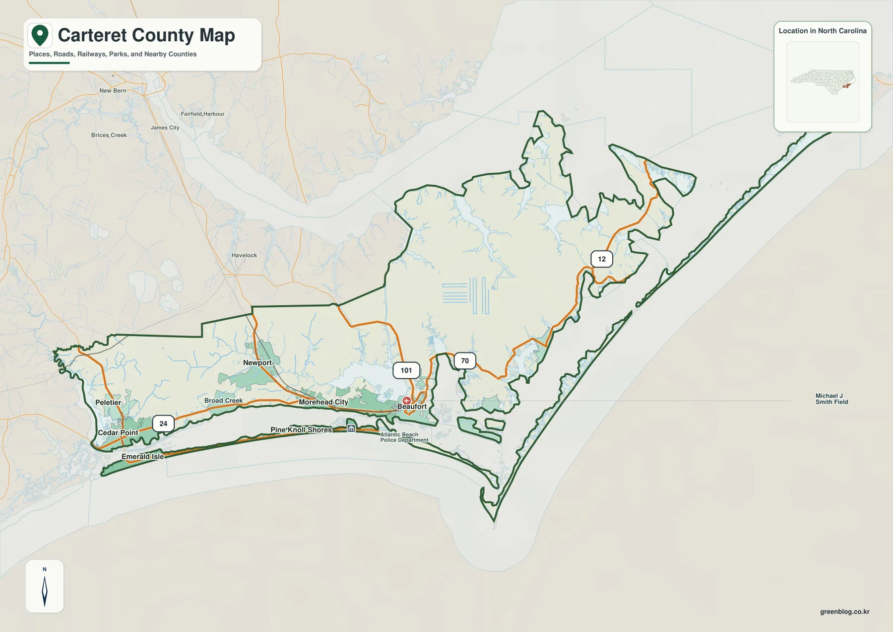
The county map makes a useful first distinction between the mainland communities and the narrow strip of Bogue Banks along the southern edge. Morehead City and Beaufort are close to one another, but they are not interchangeable points on the map. Morehead City sits where major road and waterfront activity come together, while Beaufort lies farther east and serves as the county seat. Newport provides an inland reference northwest of Morehead City, so the three places form an easy set of anchors for orienting the central and western part of the county.
South of the mainland, Bogue Banks runs west to east with Emerald Isle near its western end and Atlantic Beach toward the east. Pine Knoll Shores also appears along the island on the county map. Bogue Sound lies between these beach communities and the mainland, which explains why places that appear close in a straight line may depend on specific bridges and road connections. Carteret County’s own history of Bogue Banks describes the island’s growth as a beach and resort corridor and notes the importance of NC 58 along the island.
The county also reaches much farther east than the Beaufort–Morehead City area. Its shoreline breaks into peninsulas, marshy water edges, bays, and long narrow islands. Neighboring counties shown around the boundary include Craven to the northwest, Jones and Onslow to the west and southwest, and Pamlico and Hyde across the northern side of the broader coastal setting. Looking at those labels together makes it clear that Carteret County belongs to North Carolina’s outer Coastal Plain and faces a large area of protected and open coastal water.
US 70 and NC 24 organize different parts of the mainland
US 70 is the clearest road to follow when reading the county from northwest to east. On the supplied map it enters from the Craven County direction, passes the Newport and Morehead City area, reaches Beaufort, and continues toward eastern Carteret County. This route helps explain why Newport works as an inland reference, why Morehead City occupies such a central transportation position, and why Beaufort feels like the point where the road network begins to interact more closely with narrow waterways and the deeply indented coast.
NC 24 serves a different part of the county. It runs through the western mainland near Cedar Point and Peletier before reaching the Morehead City area. North Carolina transportation planning documents describe NC 24 as the east–west corridor connecting Onslow County with Morehead City. On the map, that role is visible in the way the road gathers western communities into the central coastal area. Reading US 70 and NC 24 together is more useful than treating either one as the county’s only main route.
NC 101 appears north of Beaufort, where it links with the US 70 area, and NC 12 is shown in the eastern part of the county. Carteret County’s emergency planning material also identifies US 70, NC 24, NC 12, NC 58, and NC 101 as major traffic arteries. That list fits the geography visible here: the mainland depends on several corridors, while Bogue Banks and the far eastern coastal communities have fewer ways to cross water or move along narrow landforms. In a county with so many sounds, inlets, and islands, bridges and ferry connections can matter as much as simple straight-line distance.
The city map shows a west-to-east chain rather than one dominant center
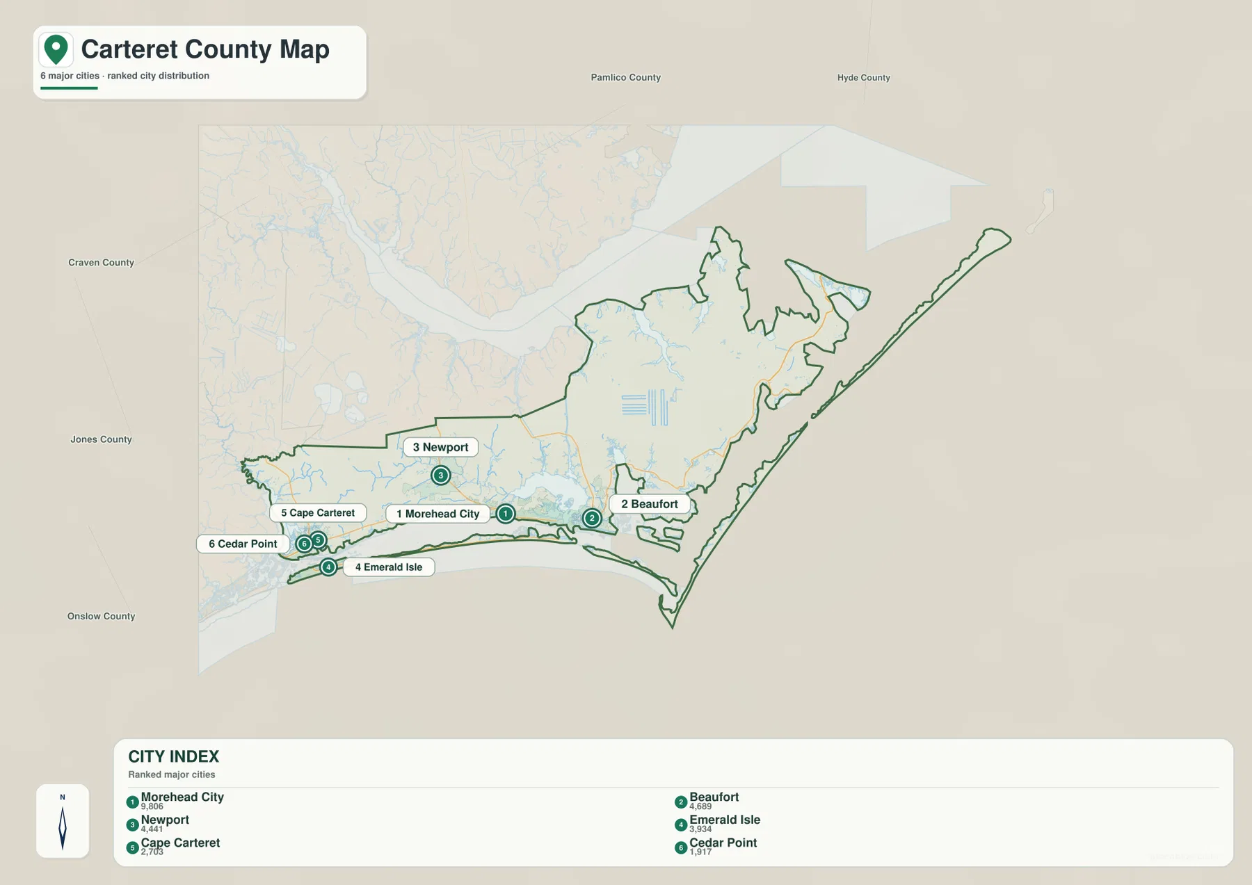
The city map highlights Morehead City, Beaufort, Newport, Emerald Isle, Cape Carteret, and Cedar Point. Morehead City ranks first in the map’s city index, with Beaufort and Newport following, while the western coastal communities form another small cluster. The important point is not the ranking by itself. The distribution shows that Carteret County’s principal named centers are spread across distinct settings: inland mainland, mainland waterfront, and barrier-island or bridgehead communities.
Morehead City and Beaufort sit close together near the central coast, yet water channels, bridges, and the shape of the shoreline keep them visually separate. Newport lies northwest of Morehead City and gives the map a clear inland counterpoint. Farther west, Cape Carteret and Cedar Point are close to each other on the mainland, while Emerald Isle sits just to the south on the western end of Bogue Banks. That arrangement is one of the most useful features of the city map because it shows why the western beach area is related to, but not physically continuous with, the mainland communities beside it.
Other familiar Carteret County places appear on the broader county map rather than in the six-place city index. Atlantic Beach and Pine Knoll Shores, for example, help trace Bogue Banks eastward from Emerald Isle. This is a good reason to use the city and county maps together. The city map simplifies the comparison of selected population centers, while the county map restores the wider road network, coastline, surrounding counties, and additional place labels needed for fuller orientation.
Newport River, bays, sounds, and inlets explain the county’s irregular shape
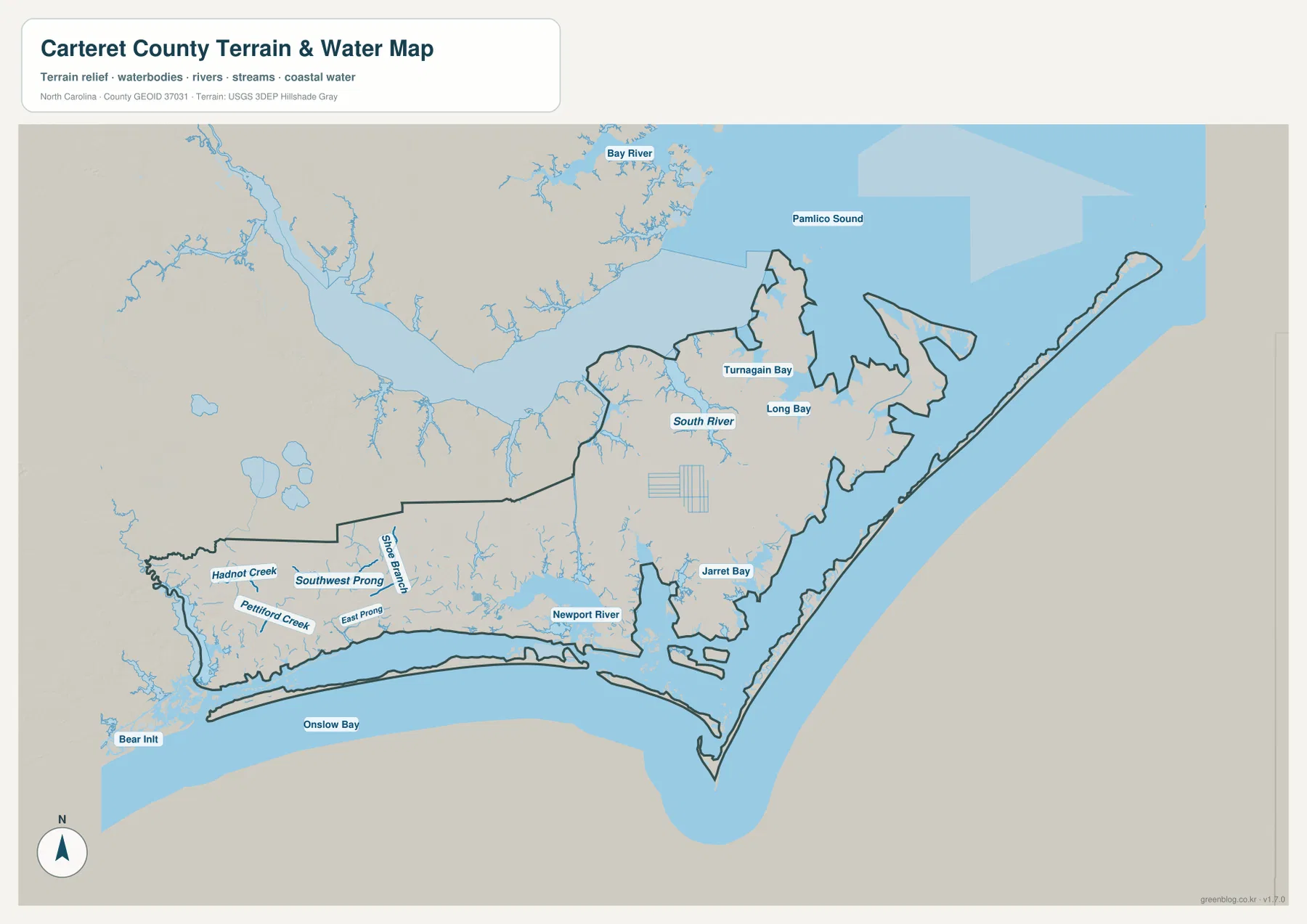
The terrain-and-water map is particularly useful in Carteret County because so much of the county boundary is tied to coastal water. Onslow Bay fills the broad ocean-facing area to the south, while Pamlico Sound appears to the northeast. Closer to the central population centers, the Newport River reaches into the Morehead City–Beaufort area. Farther east, Jarrett Bay, Long Bay, and Turnagain Bay show how deeply water cuts into the land before the county reaches its long outer barrier-island edge.
South River is labeled in the northern part of the county, and the western mainland contains a much finer network of creeks and branches. Hadnot Creek, Pettiford Creek, East Prong, and other smaller waterways create a dense pattern that is easy to overlook on a road-focused map. Bear Inlet appears near the southwestern coast, connecting the western end of the county’s barrier-island environment with the open waters of Onslow Bay. These labels make the water map more than a decorative coastal view: they help explain why the county outline contains so many narrow projections, interior water edges, and separated land areas.
Bogue Sound remains one of the most practical orientation features even when it is easier to recognize on the county map than on the water map. It separates the mainland from Bogue Banks and immediately clarifies the relationship between Morehead City and the beach communities. To the east, the geography expands into a different set of sounds and barrier islands. Cape Lookout National Seashore, managed by the National Park Service, occupies offshore barrier-island terrain in this broader eastern Carteret setting and reinforces just how much of the county is defined by water access rather than continuous roadway access.
Here, shoreline complexity matters more than mountain relief
There is no separate elevation map in this package, so the article does not assign precise heights or try to turn the terrain layer into a survey product. The subtle relief background on the water map is best used as context. Carteret County belongs to a low coastal landscape where the more obvious geographic changes come from shorelines, tidal waters, estuaries, narrow islands, and the transition between broader mainland and fragmented eastern coast. That is a very different map-reading problem from a mountain county where ridgelines and steep elevation changes dominate.
The western mainland is comparatively broad, but the land becomes increasingly interrupted by water toward Beaufort and the eastern part of the county. Around the central coast, rivers and channels reach close to developed areas. Farther east, the county narrows into peninsulas and offshore landforms with long water boundaries. The result is that two places can look close on a county-wide image while still requiring a bridge, a longer road route, or in some cases ferry or boat access to travel between them.
This is especially important when comparing mainland and barrier-island communities. Beaufort and Atlantic Beach are not separated by a great distance on a regional map, but their road connection must follow the available crossings and mainland streets. The same is true at the western end, where Cedar Point and Cape Carteret sit near Emerald Isle but occupy a different side of the water. When using the downloadable maps for trip planning or annotation, it helps to mark the water first and then trace the actual road connection instead of assuming a direct line is a usable route.
Choose the map by the question you are trying to answer
Use the county map first when the main question is “Where is this place in relation to the rest of Carteret County?” It combines the county outline with nearby counties, major roads, and a wider set of place labels. That makes it the most practical choice for locating Beaufort, Morehead City, Newport, Cedar Point, or the Bogue Banks communities within one frame. It is also the better starting point for comparing Carteret with Craven, Jones, Onslow, Pamlico, or Hyde County.
The city map is cleaner when the goal is to compare the selected principal settlements. Because it reduces some of the surrounding detail, the west-to-east relationship among Newport, Morehead City, Beaufort, Cape Carteret, Cedar Point, and Emerald Isle is easier to see. It should not be read as a complete inventory of every town or community in the county. Places such as Atlantic Beach and Pine Knoll Shores still matter to the county’s settlement pattern and are visible on the broader map.
Choose the terrain-and-water map when the names of rivers, creeks, bays, sounds, and coastal waters are the main concern. It is particularly helpful for understanding the Newport River, South River, Jarrett Bay, Turnagain Bay, Long Bay, Onslow Bay, and Pamlico Sound in relation to the county outline. It is not a flood-risk map, nautical chart, depth chart, parcel map, or legal navigation product. For boating, storm evacuation, flood insurance, tides, or other safety-critical decisions, use the latest information from the appropriate federal, state, or local agency.
Using the high-resolution files for printing and comparison
The WebP images in the article are optimized for quick viewing on the page. The ZIP download contains the corresponding county, city, and water maps as three larger JPG files. Their A3-oriented dimensions make them more useful when you need to zoom in on labels, place the map in a slide, print a reference sheet, or compare the same part of Carteret County across more than one map. Keeping the map types separate also prevents roads, settlement labels, and water names from competing for space on one overcrowded image.
For a road-focused printout, the county map is usually the best choice. For a classroom or demographic discussion about the location of the principal centers shown here, the city map gives a simpler view. For coastal geography, the water map provides the clearest picture because the small creeks, broad sounds, bays, and ocean-facing waters are much easier to distinguish. Downloading all three files gives you the flexibility to switch maps without relying on a single generalized image for every task.
Frequently Asked Questions
Is Bogue Banks part of the same setting as Beaufort and Morehead City?
They are all in Carteret County, but they occupy different physical settings. Beaufort and Morehead City are on the mainland side of the central coast, while Bogue Banks is a barrier island south of Bogue Sound. Atlantic Beach, Pine Knoll Shores, and Emerald Isle lie on Bogue Banks, so the sound and bridge connections are essential for understanding how the beach communities relate to the mainland.
Which map is better for comparing Newport, Morehead City, and Beaufort?
The city map gives the fastest visual comparison of the three places, but the county map is better when roads matter. US 70 provides a useful route reference linking the Newport and Morehead City area with Beaufort and points farther east. Using both maps together shows the settlement relationship without losing the transportation context.
Can the water map be used for flood or boating decisions?
No. The water map is a geographic reference for locating rivers, creeks, bays, sounds, inlets, and the general coastal setting. It does not provide flood zones, real-time water levels, tides, navigational depths, channel markers, or legal marine boundaries. Use current FEMA, NOAA, USGS, North Carolina, or local agency products for decisions involving safety, navigation, evacuation, or flood risk.
Map File Information
The ZIP contains the Carteret County boundary map, city map, and terrain-and-water map as high-resolution JPG files. Use the larger originals when you need clearer labels for printing, zooming, or presentation work.
- Included Versions: county map, city map, terrain and water map
Related Maps
Sources and references
- Carteret County – History of Bogue Banks
- U.S. National Park Service – Cape Lookout National Seashore
- U.S. Census Bureau – TIGER/Line Shapefiles
- USGS – National Hydrography
Green Map creates custom-edited map images using open geographic data sources such as geoBoundaries, Natural Earth, OpenStreetMap, and government open data.
These maps are edited visual materials, not raw data files, and are provided for education, documents, presentations, and graphic reference.