Pitt County is centered on Greenville, but the county map becomes much more useful once the surrounding towns and waterways are treated as separate geographic references. Winterville and Ayden extend south from Greenville, Farmville anchors the west, Bethel sits to the north, and Grifton lies near the southern edge. The Tar River and several creek systems cross the broad Coastal Plain between these communities, so a Greenville-only view misses a large part of the county’s rural and water-rich landscape.
This page provides three views of Pitt County: a general county map with roads, boundaries, and place labels; a ranked city-distribution map for six major communities; and a terrain-and-water map focused on the Tar River, creeks, lakes, and lowland drainage. You can download the matching high-resolution A3 JPG files together in one ZIP from the map file box below. The WebP images in the article are quick previews, while the JPG files are better for printing, enlarged inspection, and document use.
Table of Contents
Greenville is the road hub, but the county spreads far beyond the urban center
The general map makes Greenville the most obvious starting point. The developed area occupies the middle of the county, with Winterville immediately to the south and Ayden farther down the same general corridor. Grifton sits closer to the southern boundary. Route 11 is clearly shown through the Winterville–Ayden direction, while routes 43 and 102 provide additional references for the southeastern part of the county.
The western half has a different pattern. Farmville is separated from Greenville and sits near routes 587 and 121, while Falkland and Belvoir appear farther north. Routes 222 and 258 cross the western side, adding connections that do not depend on the Greenville core. In the north, Bethel appears near route 64, and routes 13 and 903 provide a central north-south reference into the Greenville area. The result is a road network that branches toward several small-town centers rather than simply radiating from one city.
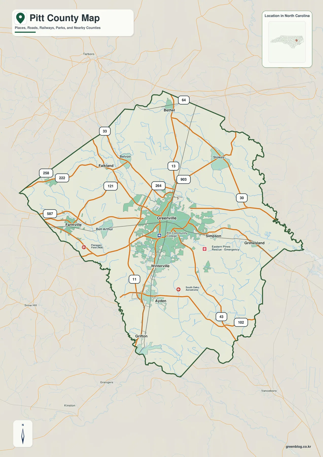
East of Greenville, Simpson and Grimesland provide additional place references, and route 30 crosses the eastern portion of the county. The outer map also labels Tarboro, Snow Hill, Kinston, and Vanceboro to help with regional orientation. Those places are outside Pitt County, so the dark county boundary should be checked before using a nearby label as an internal location.
Several facilities appear around Greenville, including Pitt Community College, Eastern Pines Rescue, and South Oaks Aerodrome. They are useful visual landmarks on the map, but the graphic should not be treated as a campus, emergency-service, or aviation boundary map. For most readers, the easiest method is to locate Greenville first and then move outward toward Farmville, Bethel, Ayden, Grifton, Simpson, or Grimesland depending on the part of the county being studied.
The city map shows a large Greenville core and five smaller centers in different directions
The supplied City Index ranks six communities. Greenville is first with 92,857, Winterville second with 10,725, Ayden third with 5,150, Farmville fourth with 4,514, Grifton fifth with 2,515, and Bethel sixth with 1,544. These are the values printed on this specific map, not figures independently updated by this article. Their main value here is to provide a consistent ranked reference for the six mapped communities.
The locations tell an important story beyond the numbers. Greenville dominates the center, with Winterville close to its south. Ayden and Grifton continue farther toward the southern end, while Farmville stands apart in the west and Bethel in the north. That distribution shows why Pitt County should not be described only as Greenville and its immediate suburbs. Several smaller towns act as useful anchors for different rural portions of the county.
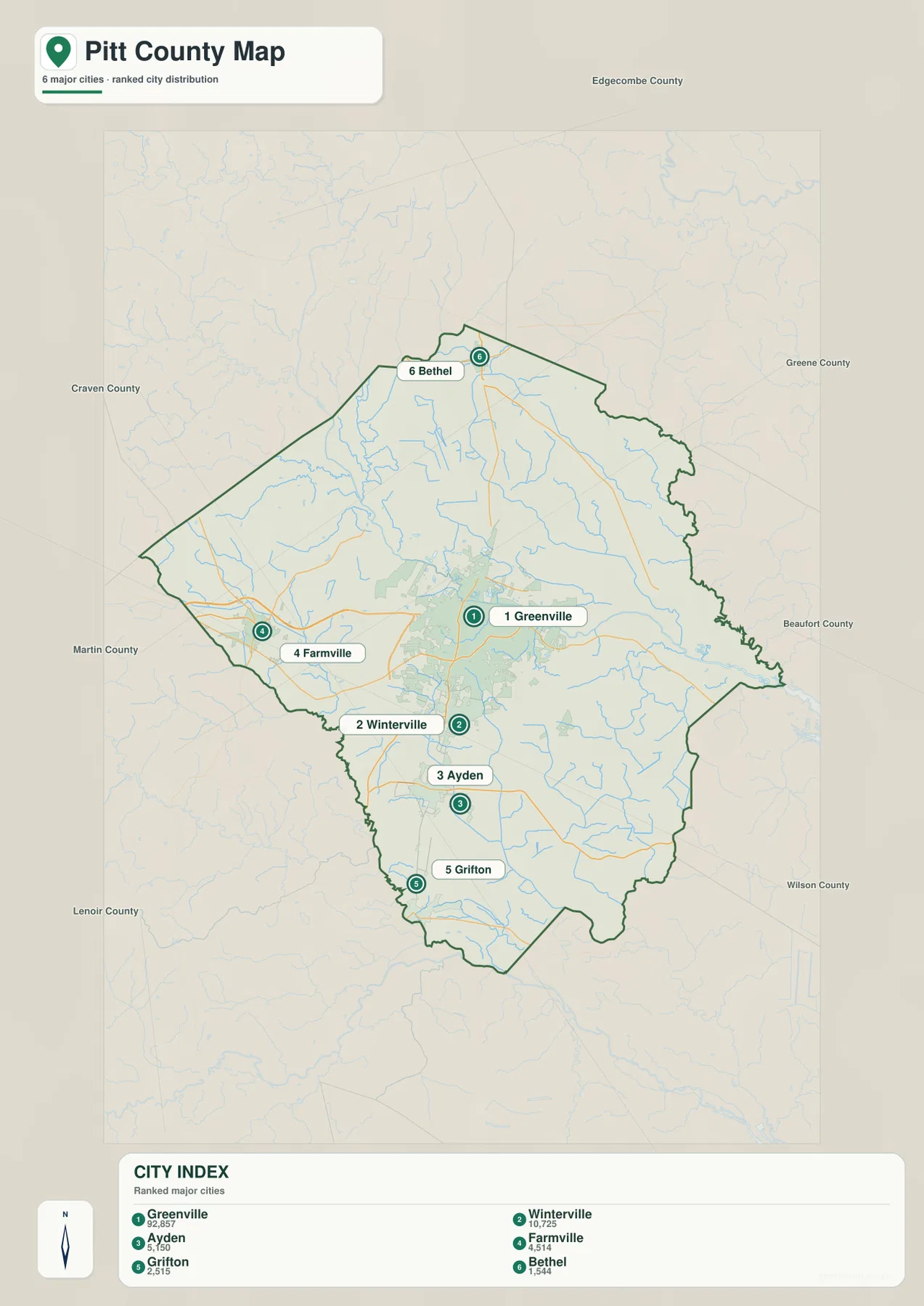
This city map does not show road mileage or connector distances. The numbered markers indicate rank and location, so they should not be interpreted as driving routes. When actual travel direction matters, the general map is the better reference because it keeps the major roads, smaller places, and county boundary visible.
Neighboring county names around the map include Edgecombe, Greene, Beaufort, Wilson, Craven, Lenoir, and Martin. They help position Pitt County within eastern North Carolina, but the city map is not a legal adjacency survey. Its strongest use is the uncluttered comparison between Greenville and the five smaller ranked towns.
Tar River and the creek network reveal the lowland landscape beyond the city grid
The terrain-and-water map makes the county look very different from the road map. Tar River is one of the strongest labels, entering from the northwest and crossing the upper-central portion of Pitt County. Contentnea Creek is visible farther northwest, and Little Contentnea Creek occupies the western side. Together they show that the county’s physical geography is not organized around one river alone.
Greenville Creek runs through the northeastern interior, while Chicod Creek stands out in the east and Swift Creek in the south. Clayroot Swamp is also labeled in the lower-central portion. These waterways fill many areas that appear visually quiet on the city map, making the outer county much more detailed than a simple urban-versus-rural description would suggest.
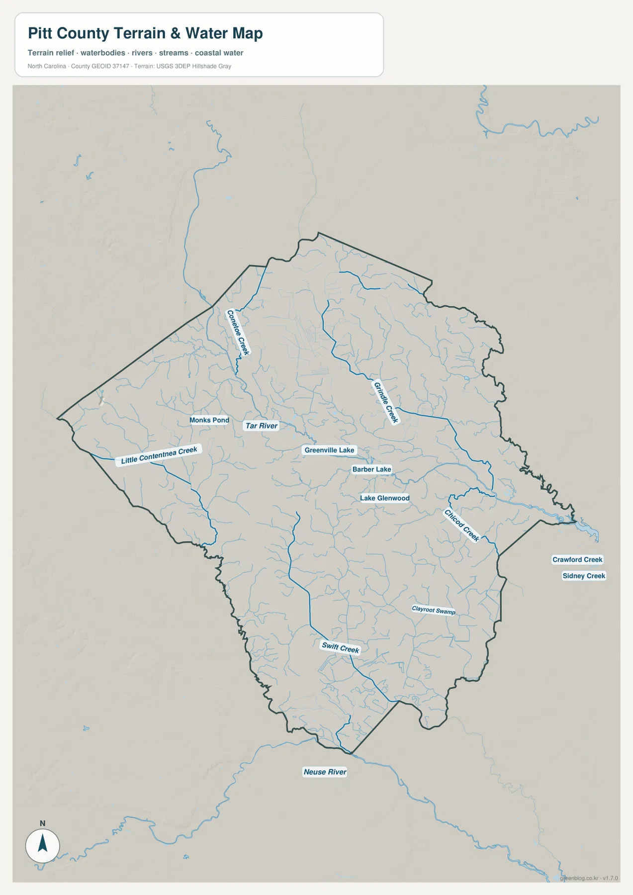
Smaller water bodies are also named, including Greenville Lake, Barber Lake, Lake Glenwood, and Monks Pond. They do not dominate the county at this scale, but they provide useful local references around Greenville and the western interior. Outside the county, Neuse River is labeled to the south, while Crawford Creek and Sidney Creek appear to the east, offering broader context for the network of eastern North Carolina waterways.
The shaded terrain is subtle because the supplied map does not show a mountainous county or strong elevation contrasts. The existing Pitt County material describes the area as part of the eastern Coastal Plain, and the map is consistent with that low, gently varying setting. This water map is a general geographic reference, not a flood-hazard map, navigation chart, parcel survey, or legal-boundary product. Technical flood or hydrology decisions should rely on the appropriate official data.
Farmville, Bethel, Ayden, and Grifton keep the map from becoming Greenville-only
Greenville’s size can make Pitt County look like a single urban region at first glance. The maps show a more varied county. Farmville has its own western position and road network, Bethel provides a northern reference, and Ayden and Grifton extend the settlement pattern far to the south. Winterville sits close to Greenville, but the other towns are separated enough to represent different parts of the county.
Greenville is the county seat and the dominant urban, university, medical, and service center in the existing county material. That makes it a logical reference for administration and the built-up core. It does not mean the outer county shares the same character. Using Farmville, Bethel, Ayden, and Grifton alongside Greenville keeps the broad rural areas visible instead of treating them as unnamed extensions of the city.
Tar River adds a second layer to that reading. The general map emphasizes streets and towns, while the water map shows a county crossed by streams and lowland channels. Little Contentnea Creek helps orient the west, Contentnea Creek the northwest, Chicod Creek the east, and Swift Creek the south. Those waterways make the differences between the smaller town regions easier to understand.
The goal of this page is not to turn those differences into a technical planning or floodplain analysis. It is to help a reader connect the visible roads, towns, rivers, and creeks on the supplied maps. Starting with Greenville, checking the smaller town directions, and then comparing the water map gives a balanced view of Pitt County without reducing it to one metropolitan center.
Use the road map for settlement orientation and the water map for rivers, creeks, and lowlands
The general county map is the best choice when you need Greenville, Winterville, Ayden, Farmville, Bethel, or Grifton together with the numbered road network. Smaller labels such as Simpson, Grimesland, Falkland, and Belvoir add local orientation. The city map removes most of that detail and is more useful when the goal is simply to compare the six ranked major communities.
The terrain-and-water map is the stronger reference when the question shifts to physical geography. It shows where Tar River crosses the county, how Contentnea and Little Contentnea Creeks relate to the west and northwest, where Greenville and Chicod Creeks lie to the east, and how Swift Creek crosses the south. The small named lakes and pond can also be located without the visual competition of a dense road network.
The download ZIP contains three high-resolution A3 JPG files corresponding to the general county map, city-distribution map, and terrain-and-water map shown on this page. They are larger than the WebP previews and are intended for printing, enlarged viewing, and document use. These are general geographic reference maps, so legal boundary decisions, surveying, flood determinations, and navigation should rely on the appropriate official technical data.
Frequently Asked Questions
Why is Greenville not enough to explain the whole county map?
Greenville is the largest and most prominent city, but Farmville lies to the west, Bethel to the north, and Ayden and Grifton to the south. The general and city maps show that these smaller centers represent different parts of Pitt County rather than one continuous Greenville urban area.
What waterways are shown besides Tar River?
The water map labels Contentnea Creek, Little Contentnea Creek, Greenville Creek, Chicod Creek, and Swift Creek, along with Greenville Lake, Barber Lake, Lake Glenwood, and Monks Pond. These names help explain the rural and lowland areas outside the main Greenville street network.
What files are included in the Pitt County download ZIP?
The archive contains three high-resolution A3 JPG files corresponding to the general county map, the six-city distribution map, and the terrain-and-water map showing Tar River, creeks, lakes, and ponds.
Map File Information
The ZIP contains three high-resolution A3 JPG files matching the Pitt County general map, city-distribution map, and terrain-and-water map shown on this page.
- Included Files: Use only the versions confirmed in the article and supplied images
- File Type: Use the confirmed download contents
- Intended Use: Printing, education, presentations, and map-based projects
Related Maps
Sources and References
- Pitt County – Soil Survey and Geography
- U.S. Census Bureau – TIGER/Line Shapefiles
- USGS – National Hydrography
These references provide county background, boundary and road data, and hydrographic context. The maps on this page are designed as general-purpose geographic references and downloadable map resources, so readers who need current legal boundaries or detailed technical water information should also consult the original agency data.
Green Map creates custom-edited map images using open geographic data sources such as geoBoundaries, Natural Earth, OpenStreetMap, and government open data.
These maps are edited visual materials, not raw data files, and are provided for education, documents, presentations, and graphic reference.