Polk County is small in area, but its maps show a sharp change between the higher western mountains and the lower, more open foothill terrain to the east. Columbus sits near the middle as the county seat, Tryon lies southwest close to the South Carolina line, and Saluda occupies the far western mountain edge. These three places look close on a county-scale map, yet the Green River, smaller creeks, steep terrain, and winding roads make their settings noticeably different.
This page provides three views of Polk County: a general map with Columbus, Tryon, Saluda, roads, and county boundaries; a city-connections map using Tryon as the hub; and a terrain-and-water map showing Green River, North Pacolet River, Lake Adger, named creeks, and mountain relief. You can download the matching high-resolution A3 JPG files together in one ZIP from the map file box below. The WebP images in the article are fast previews, while the JPG files are better for printing, enlarged viewing, and close inspection of road and water labels.
Table of Contents
Columbus, Tryon, and Saluda sit close together but occupy very different terrain
The general map makes Columbus the easiest place to begin. Routes 108 and 74 cross the central part of the county, and route 26 continues south from the Columbus area toward the Tryon side. Columbus works well as an administrative and road-network reference because several major lines meet nearby. As the map is followed west, however, the roads bend more sharply and the terrain becomes much rougher.
Tryon sits southwest of Columbus and close to the straight southern state boundary. Route 176 connects the Tryon side with the western Saluda direction, while Saluda appears in the narrow western extension of the county. On the map, the three towns are not far apart, but the road shapes make it clear that the mountain setting changes quickly. Saluda is surrounded by much stronger relief than central Columbus, and Tryon occupies a separate southwest position close to South Carolina.
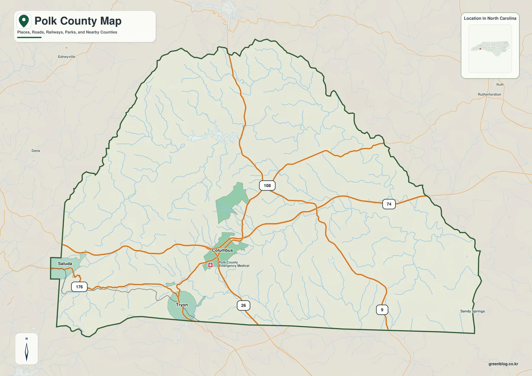
Route 9 appears on the eastern side, while Rutherfordton is labeled outside the county to the east. The northern and northeastern boundary is irregular rather than a simple straight line, and many small streams cross the interior. The road map is excellent for locating towns, but it only hints at why the western and northern parts of the county are so rugged. The terrain-and-water map provides the physical explanation.
Columbus, Tryon, and Saluda should not be treated as interchangeable town labels. Columbus represents the central county-seat area, Tryon anchors the southwest near the state line, and Saluda gives the western mountain edge its clearest town reference. Reading them as separate geographic anchors keeps the county from being reduced to one small urban cluster.
The Tryon hub map shows short straight-line distances, not easy mountain drives
The city-connections map uses Tryon as the hub and ranks Tryon first, Columbus second, and Saluda third. It shows about 4 miles from Tryon to Columbus and about 6 miles from Tryon to Saluda. Those numbers are direct straight-line distances printed on the map, not road mileage. That distinction is especially important in Polk County because the shortest line between two places can cross steep terrain that the actual road must avoid.
The difference between straight-line distance and road access helps explain why Columbus and Saluda can feel more separated than the map numbers suggest. Columbus is linked through the central road network, while Saluda is approached through a more mountainous western corridor. The city map is therefore best for simple proximity. For real route orientation, it should be paired with the general map and the terrain map.
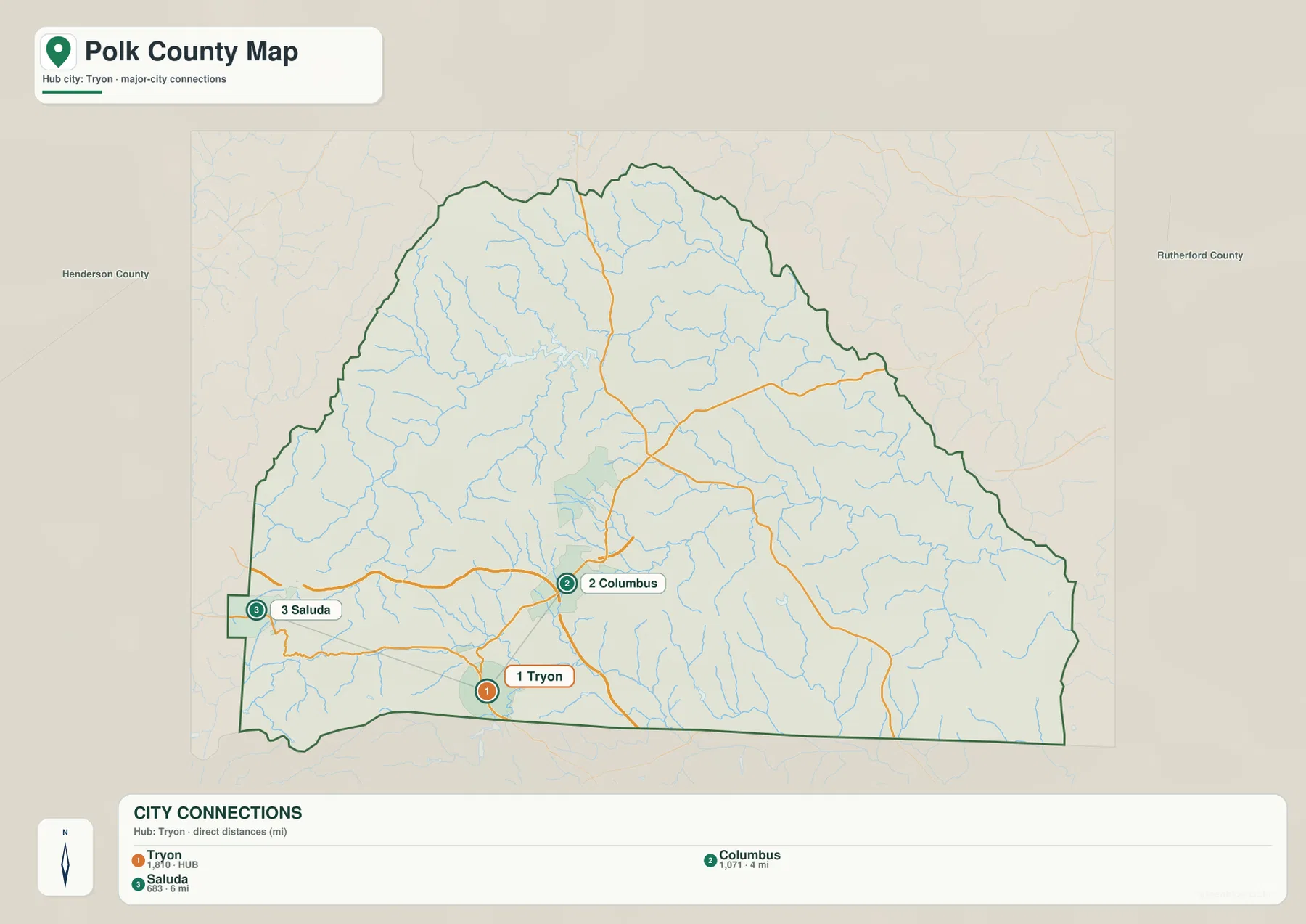
Henderson County and Rutherford County are labeled outside the Polk County boundary, providing useful regional orientation. The city map is not a legal boundary survey and it does not calculate travel time. Its value is the uncluttered view of how the three main town references sit in the southwest, center, and west of the county.
The map also prints ranked values for Tryon, Columbus, and Saluda. This article treats those figures as values displayed on the supplied map rather than as independently updated demographic estimates. The stronger geographic information is the placement of the towns and the direct distances between them.
Green River and Lake Adger organize the northern water network
The terrain-and-water map immediately changes the appearance of Polk County. Green River is the strongest water label, winding through the northern and north-central part of the county and continuing east. Lake Adger sits along this system and provides an easy landmark between the western tributaries and the main river. Once the blue water lines are emphasized, the northern interior no longer looks like empty mountain space; it becomes a closely connected network of valleys and streams.
Walnut Creek and Britten Creek enter the northern system, while Glassy Creek and Ostin Creek are labeled farther west. Little White Oak Creek and White Oak Creek extend across the central and eastern sections. These names show that Green River is supported by many smaller channels from different directions, a pattern that matches the rugged hill-and-valley relief visible in the background.
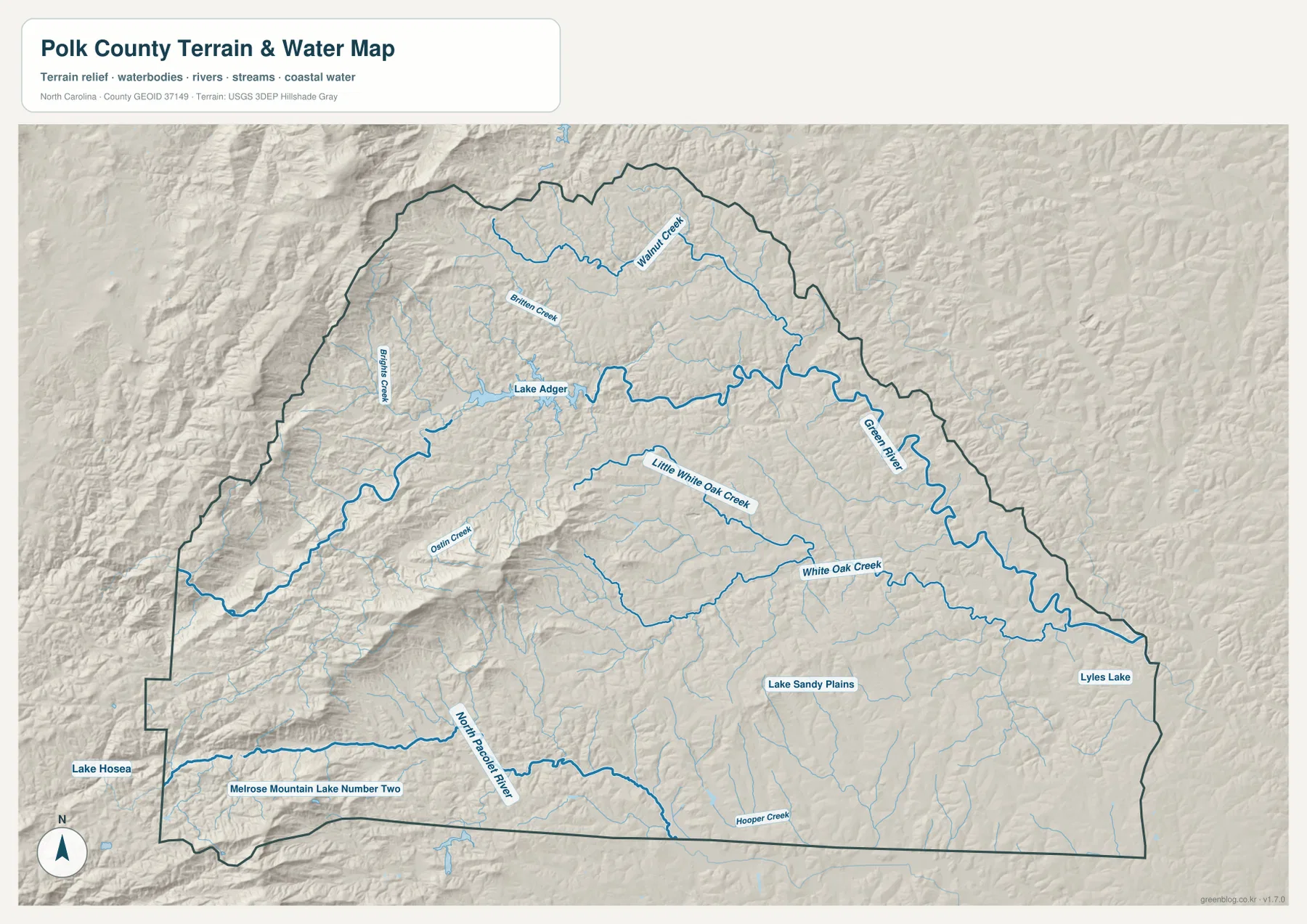
The southwest adds a different water reference. North Pacolet River follows the lower part of the county near the Tryon and South Carolina side, with Lake Hosea and Melrose Mountain Lake Number Two shown nearby. Hooper Creek appears farther southeast, while Lake Sandy Plains and Lyles Lake are labeled on the eastern side. These smaller water bodies provide useful local references even though they do not dominate the county at this scale.
Terrain shading is strongest in the west and northwest and becomes gentler toward the east. The existing county material describes Polk County as part of the Blue Ridge escarpment, where elevation changes rapidly over a short distance, and the supplied terrain image visually supports that broad contrast. The map does not provide survey-grade elevation measurements, but it clearly shows why Saluda and the western streams occupy a rougher landscape than the eastern side.
This is a general terrain-and-water reference, not a flood-hazard map, navigation chart, parcel survey, or engineering elevation model. It is appropriate for identifying the approximate position of rivers, creeks, lakes, and relative mountain relief. Detailed hydrography or elevation work should be checked against the USGS National Hydrography and 3D Elevation Program sources listed below.
Mountain roads make direction more important than simple mileage
A quick glance at the city map can make Polk County seem easy to cross because the direct distances between the three main town references are short. The road map tells a different story. Columbus-to-Tryon and Columbus-to-Saluda travel do not occur across the same kind of terrain. Tryon is tied to the southwest state-line area, while Saluda lies in a much rougher western mountain setting. Winding roads and elevation change therefore matter more than a simple mile count.
Green River adds another useful layer. The river and its tributaries occupy mountain valleys across the northern half, and roads have to connect around those physical features. Comparing routes 74 and 108 near Columbus, route 176 toward Tryon and Saluda, and the dense stream network on the terrain map explains why Polk County does not have a simple grid pattern.
The straight southern boundary also makes Tryon easy to recognize as the major town closest to South Carolina. Columbus is farther inside the county, and Saluda is west in the mountain edge. For travel planning, school materials, or a county overview, it is more accurate to describe the town direction together with the road and terrain than to say only that the places are a few miles apart.
Use one map for roads, another for proximity, and the terrain map for rivers and relief
The general county map is the best choice for locating Columbus, Tryon, Saluda, and routes 108, 74, 176, 26, and 9 in one view. The city-connections map is the clearest option for comparing Tryon with Columbus and Saluda, as long as the 4-mile and 6-mile labels are understood as straight-line distances. The terrain-and-water map provides the most detail for Green River, Lake Adger, North Pacolet River, White Oak Creek, and the county’s rugged western relief.
Using all three together gives the towns a much clearer geographic setting. Columbus becomes the central road and county-seat reference, Tryon the southwest state-line reference, and Saluda the western mountain reference. Green River and Lake Adger explain the northern valleys, while North Pacolet River helps define the southwest. The maps complement one another because each answers a different practical location question without turning the county into one uniform landscape.
The download ZIP contains three high-resolution A3 JPG files corresponding to the general county map, city-connections map, and terrain-and-water map shown on this page. They are larger than the WebP previews and are intended for printing, enlarged viewing, and document use. These maps are general geographic references, so legal boundary decisions, surveying, flood determinations, or engineering work should rely on the appropriate official technical data.
Frequently Asked Questions
Are the 4-mile and 6-mile labels from Tryon road distances?
No. The city-connections map labels them as direct straight-line distances from Tryon to Columbus and Saluda. Actual driving distance can be longer because mountain roads follow valleys, slopes, and passes rather than the shortest geometric line.
How do Green River and North Pacolet River help distinguish parts of the county?
Green River crosses the northern and north-central mountain area and is connected with Lake Adger and several named creeks. North Pacolet River is a separate southwest reference near the Tryon and state-line side. Together they show that different parts of Polk County drain through different mountain valleys.
What files are included in the Polk County download ZIP?
The archive contains three high-resolution A3 JPG files corresponding to the general county map, the Tryon-centered city-connections map, and the terrain-and-water map with Green River, Lake Adger, North Pacolet River, and named creeks.
Map File Information
The ZIP contains three high-resolution A3 JPG files matching the Polk County general map, city-connections map, and terrain-and-water map shown on this page.
- Included Files: Use only the versions confirmed in the article and supplied images
- File Type: Use the confirmed download contents
- Intended Use: Printing, education, presentations, and map-based projects
Related Maps
Sources and References
- NCpedia – Polk County
- U.S. Census Bureau – TIGER/Line Shapefiles
- USGS – National Hydrography
- USGS – 3D Elevation Program
These references provide county background, boundary and road data, hydrographic context, and elevation resources. The maps on this page are designed as general-purpose geographic references and downloadable map resources, so readers who need current legal boundaries, precise hydrology, or engineering-grade elevation information should also consult the original agency data.
Green Map creates custom-edited map images using open geographic data sources such as geoBoundaries, Natural Earth, OpenStreetMap, and government open data.
These maps are edited visual materials, not raw data files, and are provided for education, documents, presentations, and graphic reference.