Randolph County covers a broad part of central North Carolina, and Asheboro is only one of several useful ways to orient the map. The county seat sits south of center, while Randleman lies to the north, Archdale and Trinity occupy the northwest edge, and Liberty, Franklinville, and Ramseur spread across the east. South of Asheboro, Seagrove marks a quieter part of the county where terrain and drainage become more useful references than a dense city pattern.
This page provides three views of Randolph County: a general map with boundaries, roads, and place labels; a ranked city-distribution map for six major communities; and a terrain-and-water map showing rivers, creeks, lakes, and shaded relief. You can download the matching high-resolution A3 JPG files together in one ZIP from the map file box below. The WebP images in the article are quick previews, while the JPG files are better for printing, enlarging small labels, and document use.
Table of Contents
Asheboro is the central road reference, but the highway pattern changes toward every edge
The general county map makes Asheboro the easiest place to begin. The developed area appears a little south of the county’s middle, with route 64 crossing east-west and route 220 forming a strong north-south reference. Randolph County Courthouse and Randolph Community College are labeled just north of the main Asheboro area, while routes 159 and 134 continue toward the south. Those features make the county seat easy to locate without implying that the rest of the county belongs to one compact urban district.
North of Asheboro, Randleman sits close to route 220, and the road network becomes denser toward Trinity in the northwest. Routes 73, 74, 311, and 220 all appear in that upper part of the map. The city-distribution map adds Archdale at the northwest edge, reinforcing the existing county description that this part of Randolph faces the Piedmont Triad more directly than central Asheboro does. Archdale and Trinity therefore work as a separate northwest reference rather than a continuation of the county seat.
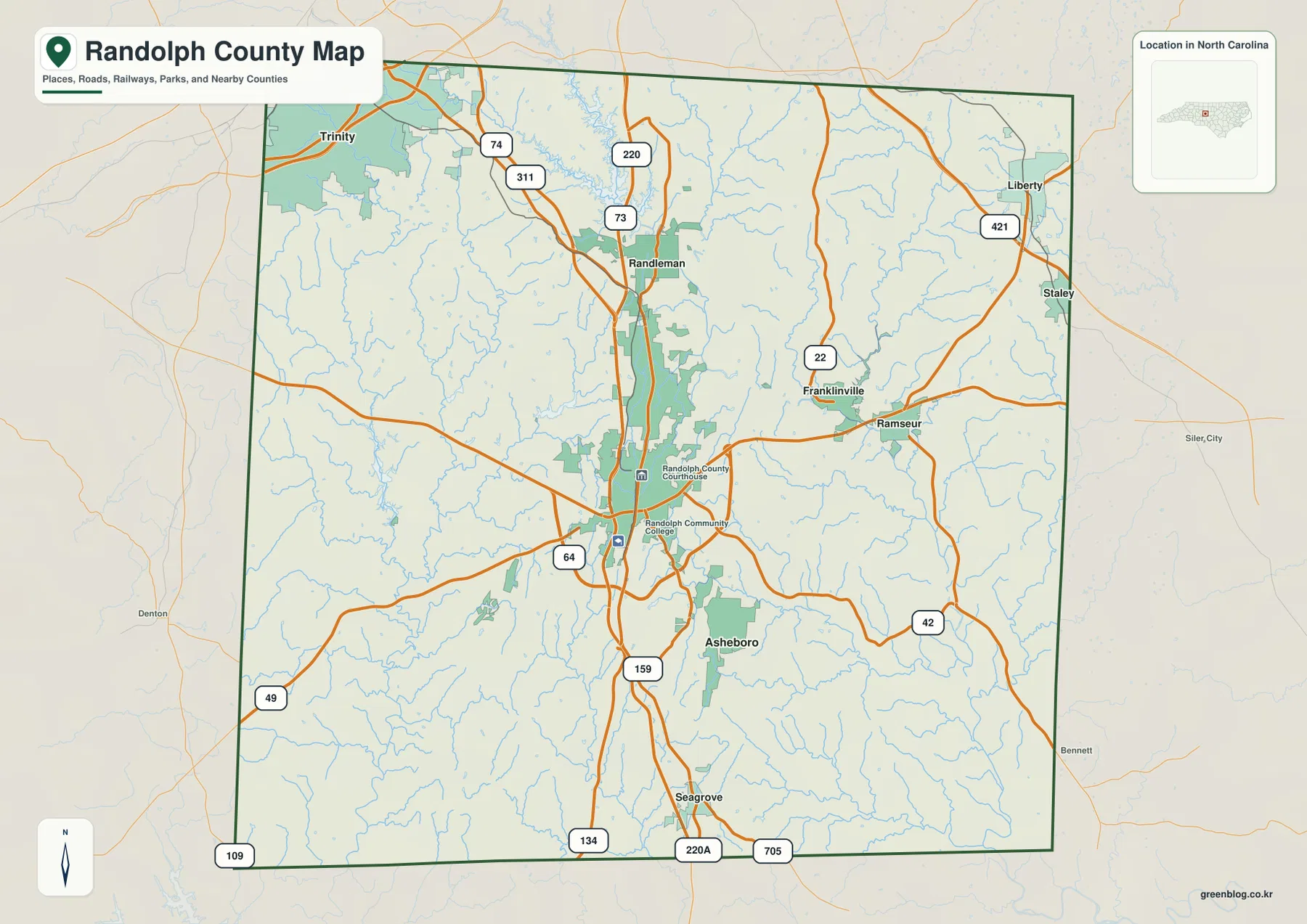
The eastern side has its own group of small-town references. Franklinville and Ramseur sit relatively close together, while Liberty is farther northeast near route 421. Route 22 is labeled near Franklinville, and several east-west roads converge around Ramseur. This pattern makes Ramseur a useful eastern reference even though it is much smaller than Asheboro. Siler City appears outside the boundary to the east and should be read only as regional context.
South of Asheboro, the label density drops. Seagrove appears along the 220 corridor, and routes 134, 220A, and 705 are shown near the southern boundary. Routes 49 and 109 reach toward the southwest. The change from the busy northwest and central road pattern to a quieter southern map is one of the clearest reasons to treat Randolph as a large inland county with several distinct geographic sections rather than as one Asheboro-centered place.
The city map separates Asheboro from the northwest Triad-facing towns
The supplied City Index ranks six communities. Asheboro is first with 27,580, Archdale second with 12,087, Trinity third with 7,111, Randleman fourth with 4,644, Liberty fifth with 2,682, and Ramseur sixth with 2,150. These are the values printed on this particular map; this article does not treat them as independently updated population estimates.
Location matters more than the ranking alone. Asheboro stands by itself in the south-central part of the county. Archdale and Trinity cluster near the northwest edge, Randleman occupies the north-central corridor, Liberty sits in the northeast, and Ramseur is farther east. The arrangement explains why Archdale should not be treated as the same urban center as Asheboro. It belongs to a different edge of the county and is visually tied to a different regional direction.
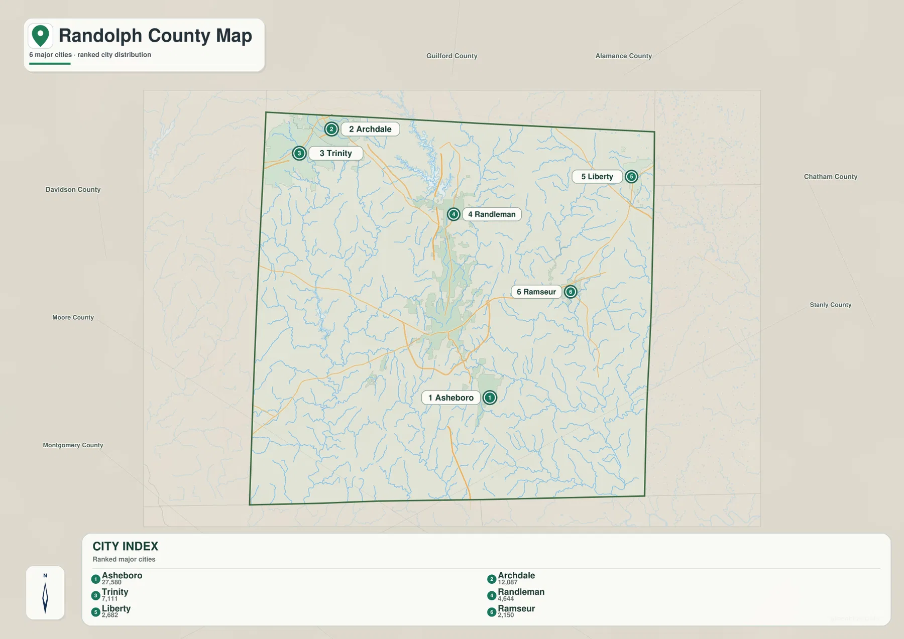
No connector distance or travel-time information is shown on this city map. The numbered markers indicate rank and location only, so road mileage should be checked against the general map instead. A trip from Archdale or Trinity toward Asheboro follows a different corridor from a trip coming from Liberty or Ramseur, even though all six places belong to the same county.
County names around the outside include Guilford, Alamance, Chatham, Stanly, Montgomery, Moore, and Davidson. They help place Randolph County within central North Carolina, but this is not a legal adjacency survey. The clean city map is most useful for seeing how the six ranked communities divide the county into northwest, central, northeast, and eastern reference areas.
Deep River, Uwharrie River, and the lake network reveal a second map beneath the roads
The terrain-and-water map changes the emphasis from highways to drainage and relief. Randleman Lake is the most prominent northern reservoir, with Lower Lake farther west. Dodsons Lake and Sizemore Lake appear in the northeast. Even before following the rivers, these separated water bodies show that the northern half of Randolph County contains several distinct drainage areas rather than one simple water feature.
Deep River is labeled along the eastern side and continues toward the southern boundary, with Brush Creek nearby. It provides a strong natural reference for the Franklinville-Ramseur side of the county. The existing Randolph County material also identifies Deep River as an important water feature, and the new water map makes that eastern position much easier to understand than the road map alone.
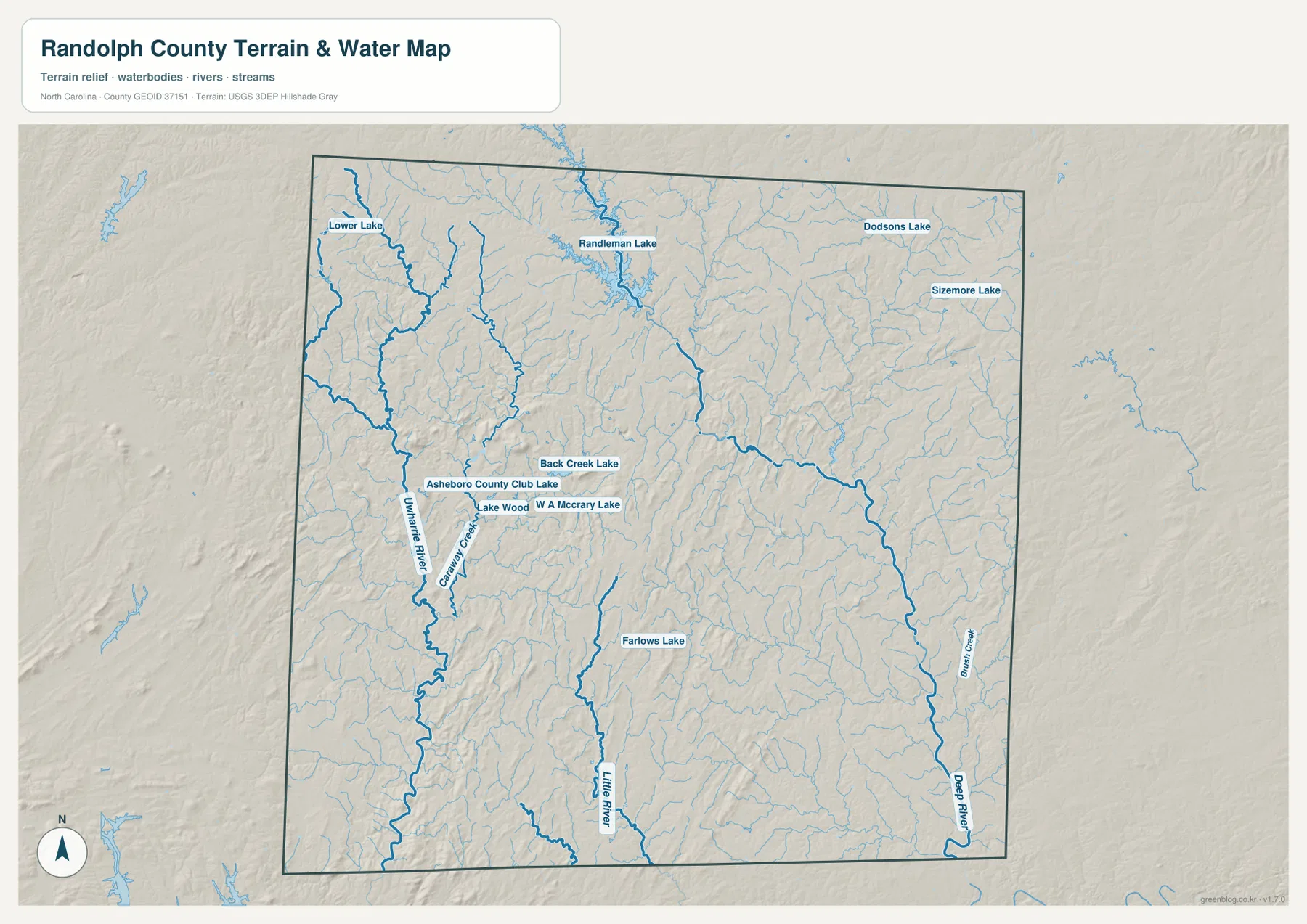
Farther west, Uwharrie River runs through the central-western part of the county, with Caraway Creek close by. Around Asheboro, the map labels Asheboro Country Club Lake, Lake Wood, W A McCrary Lake, and Back Creek Lake. Little River occupies the south-central area and Farlows Lake provides another small water reference. These names show why it is misleading to describe Randolph County’s physical geography through Deep River alone; the west and south have their own drainage pattern.
The shaded relief also becomes more broken across the southern and southwestern half, where small ridges and valleys are more visible than in the flatter-looking northeast. That is consistent with the Uwharrie-hill reference preserved in the current county material. The map is still a generalized terrain-and-water reference, not a survey-grade elevation model, flood map, navigation chart, or parcel product. Precise elevations and technical hydrology require the official source data linked below.
Northwest Triad connections, central Asheboro, and the Uwharrie south should be read separately
Randolph County is large enough that one center does not explain every part. Archdale and Trinity sit at the northwest edge close to Guilford County and the broader Triad-facing road network. Randleman occupies the transition south of them. Asheboro is the strongest administrative and service reference, but Liberty and Ramseur lie far enough east, and Seagrove far enough south, that they need their own geographic context.
In the east, Deep River often becomes more useful than a city name for understanding the physical landscape. Franklinville and Ramseur sit in a corridor where the river and smaller tributaries cut across the road network. Liberty is farther north and has a different road pattern. In the west and south, Uwharrie River, Little River, and Caraway Creek connect to a hillier background that differs from the Deep River side.
The current county material states that Randolph County was formed from Guilford County in 1779. This page is not a county-history article, but that existing source detail provides useful background when viewing the modern northwest edge that still faces the Guilford-Triad direction. Historical formation and present-day travel patterns are not the same thing, however, so the maps should still be read primarily through current roads, settlements, waterways, and terrain.
The southern part is the easiest place to see why a road-only description can feel incomplete. Seagrove is one of the few prominent settlement labels, while the terrain-and-water map shows repeated ridges, tributaries, and smaller water bodies. Keeping that quieter southern landscape separate from the Asheboro road hub produces a much more accurate picture of Randolph County.
Choose the road map for settlements and the water map for the county’s hills and drainage
The general map is the best choice when you need Asheboro, Randleman, Franklinville, Ramseur, Liberty, Trinity, or Seagrove together with the numbered road network. Routes 64, 220, 421, 42, 49, 134, and 705 provide useful directional anchors, and the county outline helps keep outside places such as Siler City or Denton in the correct context.
The city-distribution map is cleaner when the goal is simply to compare the six ranked communities. It immediately shows Asheboro as the south-central first-ranked city, Archdale and Trinity in the northwest, Liberty in the northeast, and Ramseur in the east. Because road lines are not the focus, it should be used for settlement distribution rather than route planning.
The terrain-and-water map is the stronger reference when the question is Deep River, Uwharrie River, Randleman Lake, smaller lakes, creeks, or the hillier southern landscape. It reveals natural detail in areas that look relatively empty on the general map and makes the contrast between the eastern drainage and western-southern Uwharrie side much easier to see.
The download ZIP contains three high-resolution A3 JPG files corresponding to the general county map, city-distribution map, and terrain-and-water map shown on this page. These files are larger than the WebP previews and are intended for printing, enlarged viewing, and document use. They are general geographic reference maps, so legal boundary decisions, surveying, flood determinations, navigation, and engineering-grade elevation work should rely on the appropriate official technical data.
Frequently Asked Questions
Why should Archdale and Asheboro be treated as separate map references?
Asheboro is the south-central county seat and road hub, while Archdale sits at the far northwest edge with Trinity and faces the Guilford County-Piedmont Triad direction. The city map shows a large geographic separation between them, so they describe different parts of Randolph County.
Should I use Deep River or Uwharrie River to understand the county’s water geography?
Both are useful for different areas. Deep River is a stronger reference for the Franklinville-Ramseur side of eastern Randolph County, while Uwharrie River helps explain the western and southwestern interior. Using only one river would leave out a major part of the county’s drainage pattern.
What files are included in the Randolph County download ZIP?
The archive contains three high-resolution A3 JPG files corresponding to the general county map, the six-city distribution map, and the terrain-and-water map showing Deep River, Uwharrie River, Randleman Lake, smaller lakes, and shaded relief.
Map File Information
The ZIP contains three high-resolution A3 JPG files matching the Randolph County general map, city-distribution map, and terrain-and-water map shown on this page.
- Included Files: Use only the versions confirmed in the article and supplied images
- File Type: Use the confirmed download contents
- Intended Use: Printing, education, presentations, and map-based projects
Related Maps
Sources and References
- NCpedia – Randolph County
- U.S. Census Bureau – TIGER/Line Shapefiles
- USGS – National Hydrography
- USGS – 3D Elevation Program
These references provide county background, boundary and road data, hydrographic context, and elevation source information. The maps on this page are designed as general-purpose geographic references and downloadable map resources, so readers who need current legal boundaries or detailed technical water and elevation data should also consult the original agency sources.
Green Map creates custom-edited map images using open geographic data sources such as geoBoundaries, Natural Earth, OpenStreetMap, and government open data.
These maps are edited visual materials, not raw data files, and are provided for education, documents, presentations, and graphic reference.