Person County lies in North Carolina’s north-central Piedmont, where Roxboro provides the clearest road and urban reference while large lakes and reservoir shorelines dominate the northern part of the county. The general map shows NC 57 and US 501 meeting around Roxboro, with several other numbered roads spreading east, west, and south. On the terrain-and-water map, Hyco Lake and Mayo Reservoir become the strongest northern landmarks, while the North and South Flat Rivers lead into a separate drainage network in the southern half. Reading roads, the city center, and waterways together gives a much more complete picture than using Roxboro alone.
This page provides three views of Person County: a general county map with roads, boundaries, and place labels; a city-distribution map that highlights the principal ranked city; and a terrain-and-water map with lakes, reservoirs, rivers, and creeks. You can download the matching high-resolution A3 JPG files together in one ZIP from the map file box below. The WebP images in the article are quick previews, while the JPG files are better for printing, enlarged label inspection, and document use.
Table of Contents
Roxboro gives NC 57 and US 501 a clear center on the county map
Roxboro is the easiest place to begin on the general county map. The developed city area is shown near the middle, and NC 57 crosses it from west to east while US 501 enters from the north and continues south. Once those two roads are identified, the rest of the road network becomes much easier to follow. Piedmont Community College – Person and Person Memorial Hospital are also labeled near the Roxboro area, providing additional visual references for the city center at this map scale.
Other numbered routes spread away from Roxboro in several directions. NC 49 runs toward the southwest, NC 157 continues into the southern part of the county, and US 158 extends eastward. That pattern is important because Person County is not organized around one simple north-south highway. Roxboro acts as a road hub, but the rural parts of the county branch outward along different routes, especially toward the western lake area, the eastern countryside, and the southern boundary.
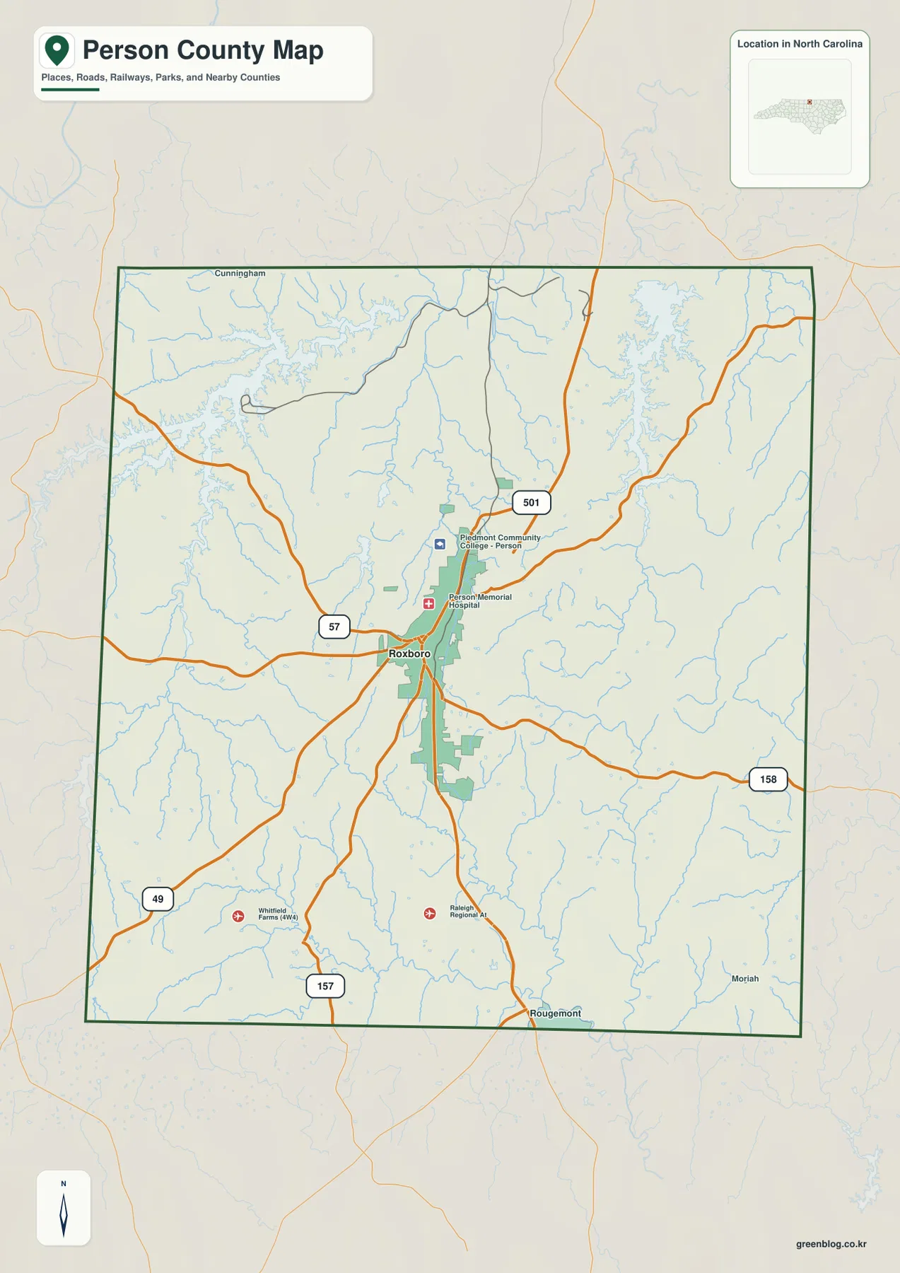
Rougemont is labeled near the southern edge of the map, while Cunningham appears beyond the north side and Moriah beyond the southeast. These outside or boundary-area names help with orientation but should not be treated as a list of major places inside Person County. The dark county outline is the safest guide when reading edge labels. After the boundary is clear, Roxboro and the numbered highways provide a straightforward framework for locating the rest of the county.
Even the general map contains a dense web of thin blue waterways between the roads. They are especially noticeable around the northern lakes and across the eastern and southern countryside. This is an early sign that Person County’s physical geography is more complex than the road map alone suggests. The terrain-and-water map makes those features much easier to identify by name.
The city map deliberately focuses on Roxboro as the single ranked major city
The supplied city-distribution map ranks only one major city: Roxboro. The City Index prints the value 8,182 next to the name. This article treats that number as a value shown on the map itself rather than as an independently updated population estimate. The map’s main purpose is location, not demographic analysis: it shows where the county’s principal city sits within a much larger rural landscape.
Roxboro is close to the county’s center, which makes it a useful transition point between the northern lake district and the southern rural areas. County names around the outside include Orange, Durham, Caswell, and Granville, helping place Person County within the surrounding part of North Carolina. The one-city ranking should not be read to mean that the rest of the county is urban. The general and water maps show broad countryside, reservoirs, and branching streams beyond the Roxboro footprint.
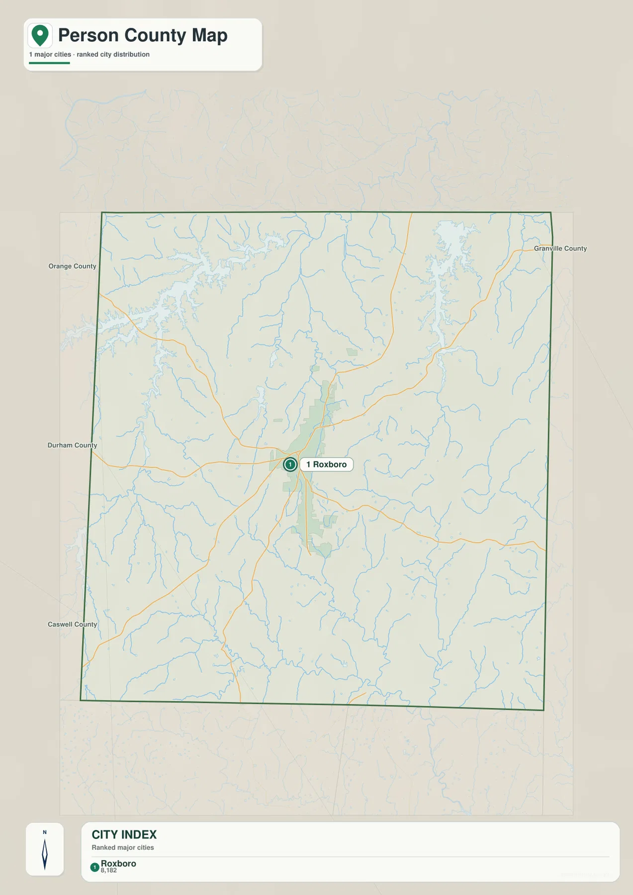
No connector distances, road mileage, or travel times are shown on this city map. It is therefore most useful when the question is simply where Roxboro sits inside Person County. When you need route direction, return to the general map and compare NC 57, US 501, US 158, NC 49, and NC 157. When the question shifts to lakes and rivers, the terrain-and-water map is the stronger reference.
Hyco Lake and Mayo Reservoir define two different parts of the northern county
The terrain-and-water map gives the northern half of Person County a much more distinctive shape. Hyco Lake occupies the northwest with a long, irregular shoreline, and After Bay Reservoir and Hyco River are labeled farther north. Wagstaff Pond appears just east of the Hyco Lake area, while Chub Lake and Roxboro Lake sit closer to the central part of the county. The map makes it clear that these water bodies are separate features rather than one continuous lake system.
Mayo Reservoir occupies the northeast and is well separated from Hyco Lake. The existing county material in the package also identifies Hyco and Mayo as important recreational lakes in northern Person County. On the map, their separation is useful for orientation: Hyco Lake is the stronger northwest landmark, while Mayo Reservoir anchors the northeast. Between them are smaller streams and rolling Piedmont terrain rather than one uninterrupted shoreline.
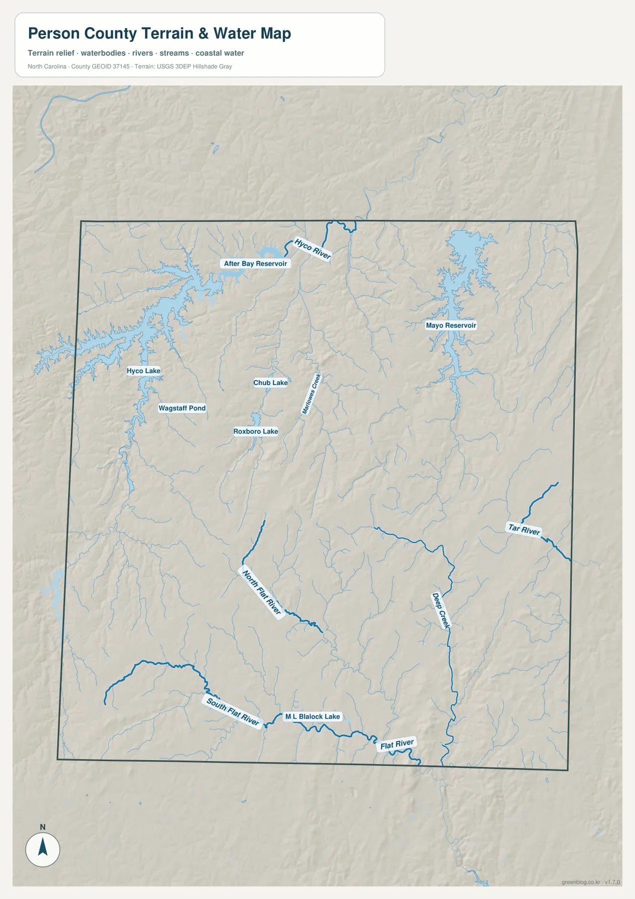
The southern water network is equally important. North Flat River and South Flat River are labeled separately before joining the larger Flat River near the southern edge. Deep Creek runs through the southeast, and Tar River appears farther east as another major named channel. This arrangement shows that Person County does not drain through one simple river corridor. Several river systems and creeks occupy different portions of the county and create a much more branched pattern than the northern lakes alone would suggest.
Marlowe Creek is labeled near the center of the water map, and M L Blalock Lake appears in the south. These smaller features help fill the geographic space between Roxboro and the larger northern reservoirs. The shaded relief is consistent with the package’s description of rolling Piedmont countryside: there are no large mountain ranges on the map, but low ridges and valleys are visible around the branching streams.
This terrain-and-water map is a general geographic reference, not a flood-hazard map, depth chart, navigation product, parcel survey, or legal shoreline document. It is useful for locating named lakes, reservoirs, rivers, and creeks at county scale. Readers who need detailed hydrography or official water data should consult the USGS National Hydrography source linked below.
The map changes from a road-centered middle to a water-centered north
Around Roxboro, transportation is the easiest way to understand location. NC 57 and US 501 meet the city, while US 158, NC 49, and NC 157 spread toward other parts of the county. Moving north changes the visual emphasis. Hyco Lake, After Bay Reservoir, and Mayo Reservoir take up much more of the map, and shoreline shape becomes a better locator than any single town name.
The southern half changes again. Rougemont appears near the boundary on the general map, while the water map emphasizes North Flat River and South Flat River. The existing page material also uses Rougemont and Hurdle Mills as southern rural references toward Durham and Orange County. Hurdle Mills is not directly labeled on the supplied preview maps, so this rewrite relies on the map-visible Rougemont and Flat River system when describing the southern direction.
Person County’s north is oriented toward the Virginia-facing lake country, while its south connects toward the rural areas beside Durham and Orange Counties. The neighboring county labels on the city map reinforce that setting. Rather than forcing the whole county into a single Roxboro-centered description, it is more accurate to read the map in three stages: the central road hub, the northern reservoirs, and the southern river headwaters.
Choose the road, city, or water view according to the question
The general county map is the most useful view when you need Roxboro, county boundaries, and numbered highways together. It lets you follow NC 57, NC 49, NC 157, US 501, and US 158 while keeping smaller edge references visible. The city map removes most of that detail and is best when you simply need to see where Roxboro, the single ranked major city, sits inside the county.
The terrain-and-water map is better for Hyco Lake, Mayo Reservoir, the Flat River system, Tar River, Deep Creek, and smaller water bodies. It clearly separates the northwest lake district from the northeast reservoir and the river network farther south. Features that appear only as thin blue lines on the general map become named geographic references on the water map.
The download ZIP contains three high-resolution A3 JPG files corresponding to the general county map, city-distribution map, and terrain-and-water map shown on this page. These files are larger than the WebP previews and are intended for printing, close inspection, and document use. They are general geographic references, so surveying, legal boundary decisions, flood determinations, and navigation should rely on the appropriate official technical data.
Frequently Asked Questions
Why is Roxboro the best first reference on a Person County map?
Roxboro is the only major city highlighted on the supplied city map, and several numbered roads meet or pass through the area on the general map. Starting there makes it easy to establish county direction before moving toward the northern lakes or southern river system.
Are Hyco Lake and Mayo Reservoir part of the same northern lake area?
They are both major northern water features, but the map places them in different parts of the county. Hyco Lake is in the northwest and Mayo Reservoir in the northeast, so keeping them separate provides much better orientation for nearby roads and streams.
What files are included in the Person County download ZIP?
The archive contains three high-resolution A3 JPG files matching the general road-and-boundary map, the Roxboro city-distribution map, and the terrain-and-water map with Hyco Lake, Mayo Reservoir, and the Flat River system.
Map File Information
The ZIP contains three high-resolution A3 JPG files matching the Person County general map, city-distribution map, and terrain-and-water map shown on this page.
- Included Files: Use only the versions confirmed in the article and supplied images
- File Type: Use the confirmed download contents
- Intended Use: Printing, education, presentations, and map-based projects
Related Maps
Sources and References
These references provide county background, boundary and road data, and hydrographic context. The maps on this page are designed as general-purpose geographic references and downloadable map resources, so readers who need current legal boundaries or detailed technical water information should also consult the original agency data.
Green Map creates custom-edited map images using open geographic data sources such as geoBoundaries, Natural Earth, OpenStreetMap, and government open data.
These maps are edited visual materials, not raw data files, and are provided for education, documents, presentations, and graphic reference.