Meridian is the easiest place to begin reading a Lauderdale County map. The city sits near the middle of the county’s main road and rail network, while smaller communities, reservoirs, creek valleys, and wooded hills spread outward toward the Alabama line and neighboring Mississippi counties. This page uses the supplied county, city, water, and elevation maps to explain those relationships in practical terms. A ZIP containing the high-resolution A3 JPG map files is available to download below.
The county changes quickly once you move away from Meridian. Major highways and dense local streets are concentrated around the urban area, but the northwestern side is dominated by Okatibbee Lake and its drainage, and long creek valleys cut through much of the remaining landscape. The elevation map shows why the terrain can feel more varied than a simple road map suggests: lower corridors run between repeated ridges and hills, with mapped elevations ranging from about 48 to 204 meters.
Table of Contents
Meridian as the county’s road and rail anchor
The county reference map gives Meridian much more visual weight than any other place because several regional routes meet around the city. I-20 and I-59 share a corridor through the Meridian area before serving different regional directions, while US 11, US 45, and US 80 provide additional north-south and east-west references. The supplied map also labels Mississippi routes such as 19 and 39, along with 145, 493, 494, 495, and 496. Together, those roads make it possible to trace the transition from the city into rural parts of the county without relying on a dense street map.
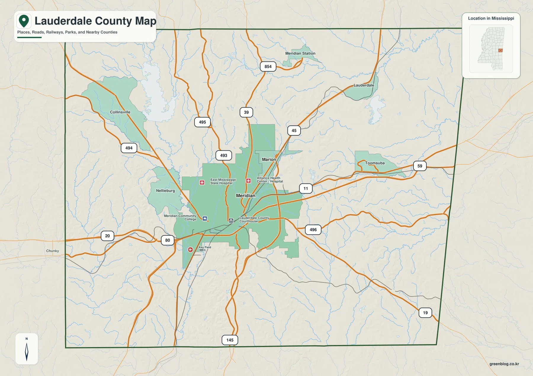
The surrounding place names help divide the county into understandable directions. Marion is close to Meridian on the north side of the urban area. Toomsuba marks the eastern approach toward Alabama, Collinsville is useful for locating the northwestern Okatibbee area, and Nellieburg identifies the western side near the route toward Newton County. Rail lines are especially visible around Meridian, reinforcing the contrast between the central transportation hub and the much more open road pattern outside it.
This map is best used for orientation rather than turn-by-turn navigation. It shows where major routes, communities, public facilities, and rail lines sit in relation to the county boundary. For someone comparing Lauderdale County with adjacent counties, the eastern edge is particularly important because it meets Alabama, while routes through Meridian connect that state-line side with the rest of eastern Mississippi.
A simpler city view of Meridian and Marion
The city index strips away much of the road detail and emphasizes the two ranked places included in the supplied map. Meridian is labeled 34,137 and Marion 2,030. The map does not need many city labels to make its main point: the larger urban footprint is concentrated around Meridian, with Marion nearby rather than at the opposite end of the county. That makes the index useful when a full road map would distract from the settlement pattern.
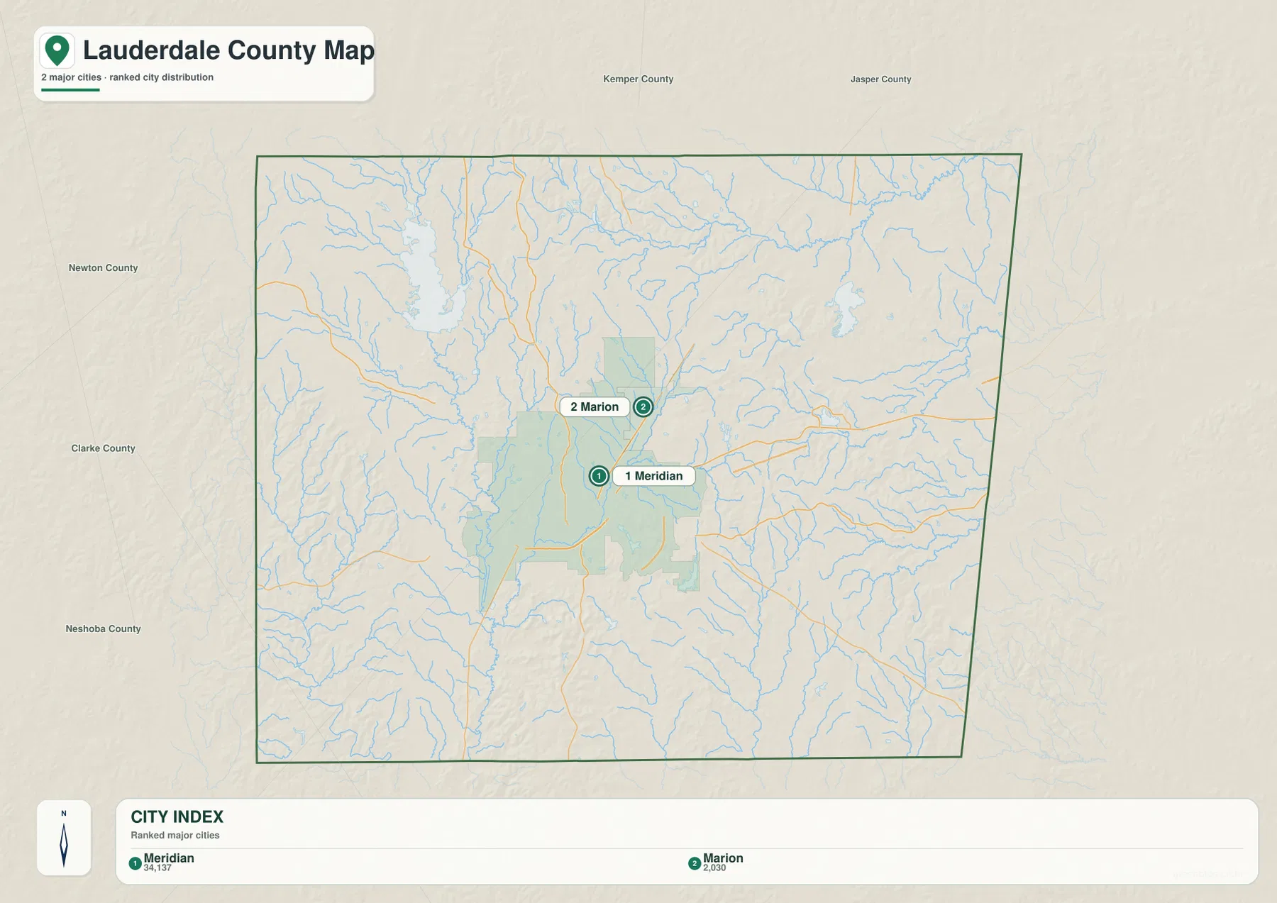
Comparing the city index with the county map also helps explain why countywide population figures should not be imagined as evenly spread across the landscape. The urbanized area around Meridian occupies only part of a county with more than 700 square miles of land. Outside that concentration, roads are farther apart and the maps show extensive creek networks, reservoirs, and hill country.
Okatibbee Lake, Sowashee Creek, and the wider water network
Okatibbee Lake is the most prominent water body on the supplied terrain and water map. It occupies the northwestern part of the county, and Okatibbee Creek continues south from that area through a broad low corridor. Farther east, Sowashee Creek runs through the central part of the county and provides another strong north-south reference. Ponta Creek crosses the northern section, while the southwestern corner reaches the Chunky River system.
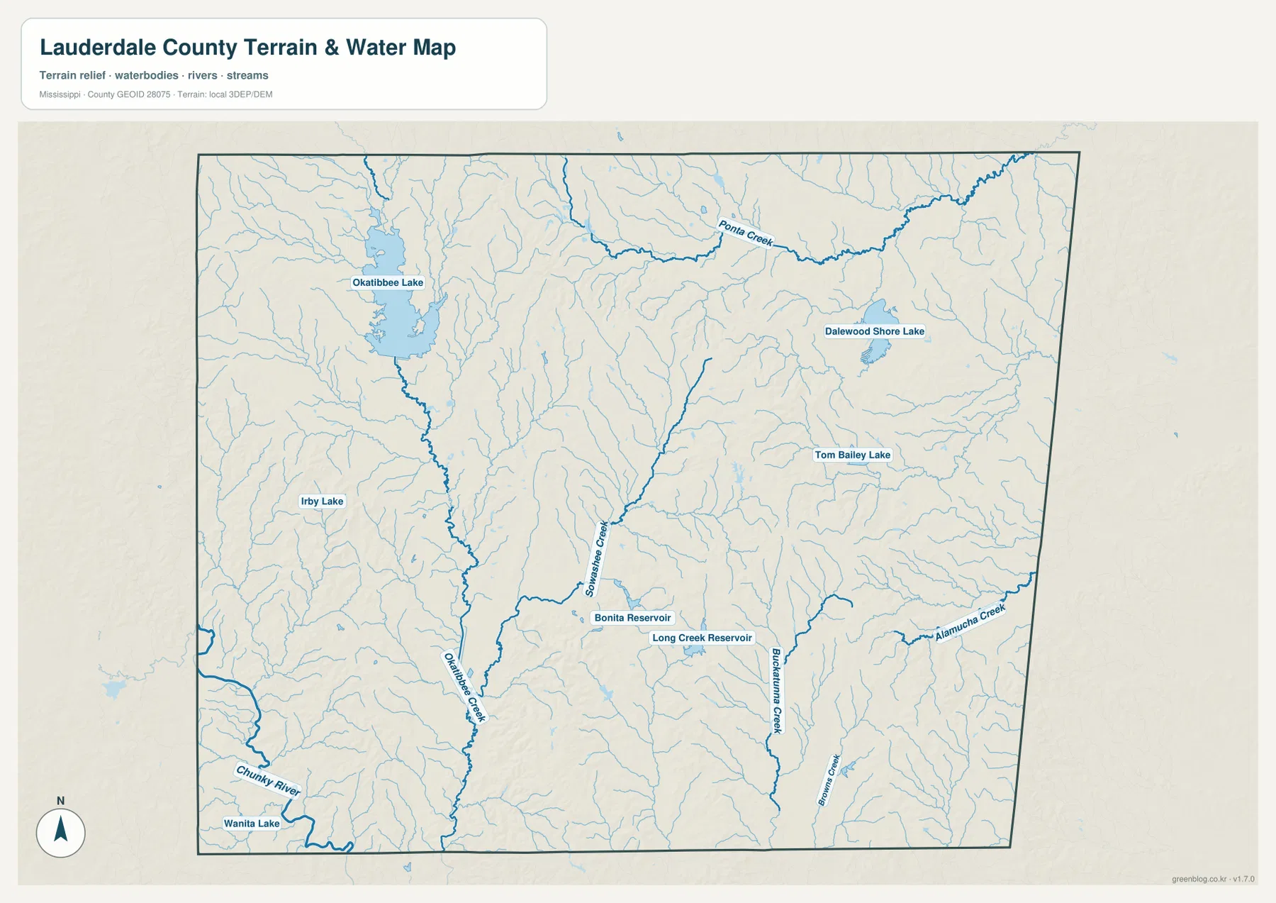
Several smaller named waters make the map useful beyond the large lake. Bonita Reservoir and Long Creek Reservoir appear near the central part of the county, while Dalewood Shore Lake and Tom Bailey Lake provide references farther east. Numerous thin tributaries fill the spaces between these named features. The result is a county where water is not confined to one river corridor; drainage lines branch through nearly every section of the mapped area.
This is particularly helpful when comparing places on the county map. Collinsville is easier to understand when seen next to the Okatibbee Lake drainage, and Meridian sits near a different group of creeks and reservoirs. A road-only view can make those places seem connected mainly by highways, whereas the water layer shows the valleys and drainage corridors that also shape the landscape between them.
Ridges and creek valleys across a 48–204 m elevation range
The elevation map reports an actual range of about 48 to 204 meters and a mean of 115 meters. That range is not mountainous, but the shaded relief shows repeated hills and narrow valleys rather than a uniformly flat surface. Green tones mark many of the lower creek corridors. Browns and darker shades appear on ridges in the western, southern, and east-central parts of the county, with additional higher ground scattered between the main drainage lines.
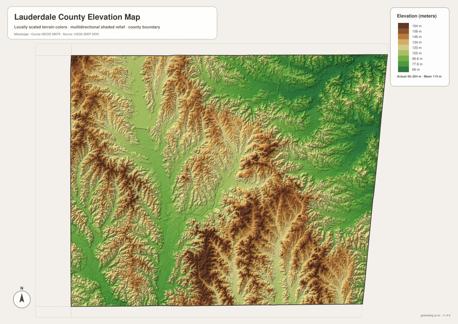
When the elevation and water maps are compared, many of the long green low areas line up with creek systems. Okatibbee Creek and Sowashee Creek are good examples: their valleys sit below nearby ridges, and smaller tributaries cut additional narrow channels into the surrounding terrain. This relationship is more useful than simply knowing the maximum elevation, because it explains how relief changes repeatedly over relatively short distances.
The terrain also gives context to the road network. Major routes connect Meridian with surrounding communities, but away from the city they cross a landscape broken by drainage lines and rolling ground. The map is not a substitute for a detailed engineering or trail surface map, yet it clearly distinguishes lower corridors from higher ridges for general geographic reference.
Population, area, and scale of Lauderdale County
| Reference | Value |
|---|---|
| FIPS code | 28075 |
| County seat | Meridian |
| 2020 census population | 72,984 |
| July 2025 population estimate | 70,317 |
| 2025 Gazetteer land area | 703.676 sq mi |
| 2025 Gazetteer water area | 11.478 sq mi |
| Reference density using 2020 population and 2025 land area | about 103.7 residents per sq mi |
The 2020 census count and the July 2025 estimate refer to different dates, so they should be read as separate population references rather than measurements from the same year. The land and water figures use the 2025 Gazetteer. The density figure is a simple countywide comparison of the 2020 population with the listed land area; it does not mean that the same number of residents occupies every square mile.
The maps make that distinction visible. Meridian and nearby Marion form a concentrated settlement area, while large portions of the county are represented by widely spaced roads, lakes, creek valleys, and wooded hills. Looking at the statistics beside the maps therefore provides a more realistic sense of the county’s scale than either the population total or the land-area number alone.
Which map is most useful for your task?
Use the county reference map when your main question is how Meridian connects with Toomsuba, Collinsville, Nellieburg, Marion, or the Alabama side of the county. The city index is cleaner when you only need the relative placement of Meridian and Marion. For lakes, reservoirs, and drainage lines, the water map removes most of the transportation clutter and makes features such as Okatibbee Lake and Sowashee Creek much easier to follow.
The elevation map is the better choice for understanding why low corridors and higher ridges alternate across the county. It can also be paired with the water map when a presentation or lesson needs to show the connection between creek valleys and surrounding terrain. If all of the maps are being compared together, Meridian and Okatibbee Lake make useful common reference points because both are easy to locate in more than one view.
Frequently Asked Questions
Which map is best for comparing Meridian and Marion?
The city index is the quickest choice because it emphasizes the two ranked places without a dense road layer. If you also need highways, surrounding communities, or the county boundary, switch to the county reference map.
Where is Okatibbee Lake in relation to Meridian?
Okatibbee Lake is northwest of Meridian near the Collinsville side of the county. The water map also shows Okatibbee Creek continuing south from the lake area, making the drainage connection easy to follow.
How much elevation variation does the supplied map show?
The elevation map reports an actual range of about 48 to 204 meters, with a mean of 115 meters. The strongest visual contrast is between lower creek corridors and the ridges and hills that rise between them.
Map File Information
Use the button below to get the Lauderdale County county, city, water, and elevation maps as high-resolution files rather than the smaller page previews.
- Included Files: 4 high-resolution A3 JPG maps
Related Maps
Sources
- U.S. Census Bureau QuickFacts
- U.S. Census Bureau 2025 Gazetteer Files
- Mississippi Department of Transportation official highway map
- USGS National Hydrography
- USGS 3D Elevation Program
Green Map creates custom-edited map images using open geographic data sources such as geoBoundaries, Natural Earth, OpenStreetMap, and government open data. These maps are edited visual materials, not raw data files, and are provided for education, documents, presentations, and graphic reference.