Lafayette County in northern Mississippi is easiest to understand from three anchors that appear clearly on the supplied maps: Oxford at the center of the road network, Sardis Lake in the northwest, and the Yocona River corridor across the southern half of the county. This page uses the actual county, city, water, and elevation maps to explain where the main places sit, how the major routes connect them, and where the lower valleys differ from the higher hills. The on-page WebP images are optimized for viewing, and you can download the four high-resolution A3 JPG maps together in a ZIP file below.
Table of Contents
Start with Oxford and the road network
Oxford is the strongest location marker on the county map. MS 7 runs north-south through the Oxford area, while US 278/MS 6 crosses east-west. MS 30 branches toward the northeast, and MS 314 heads northwest toward the Sardis Lake side of the county. Abbeville sits north of Oxford, Taylor is southwest, and smaller labels such as Paris and Tula help define the southern and southeastern parts of Lafayette County. Looking at these places together makes the county easier to orient than using the county outline alone.
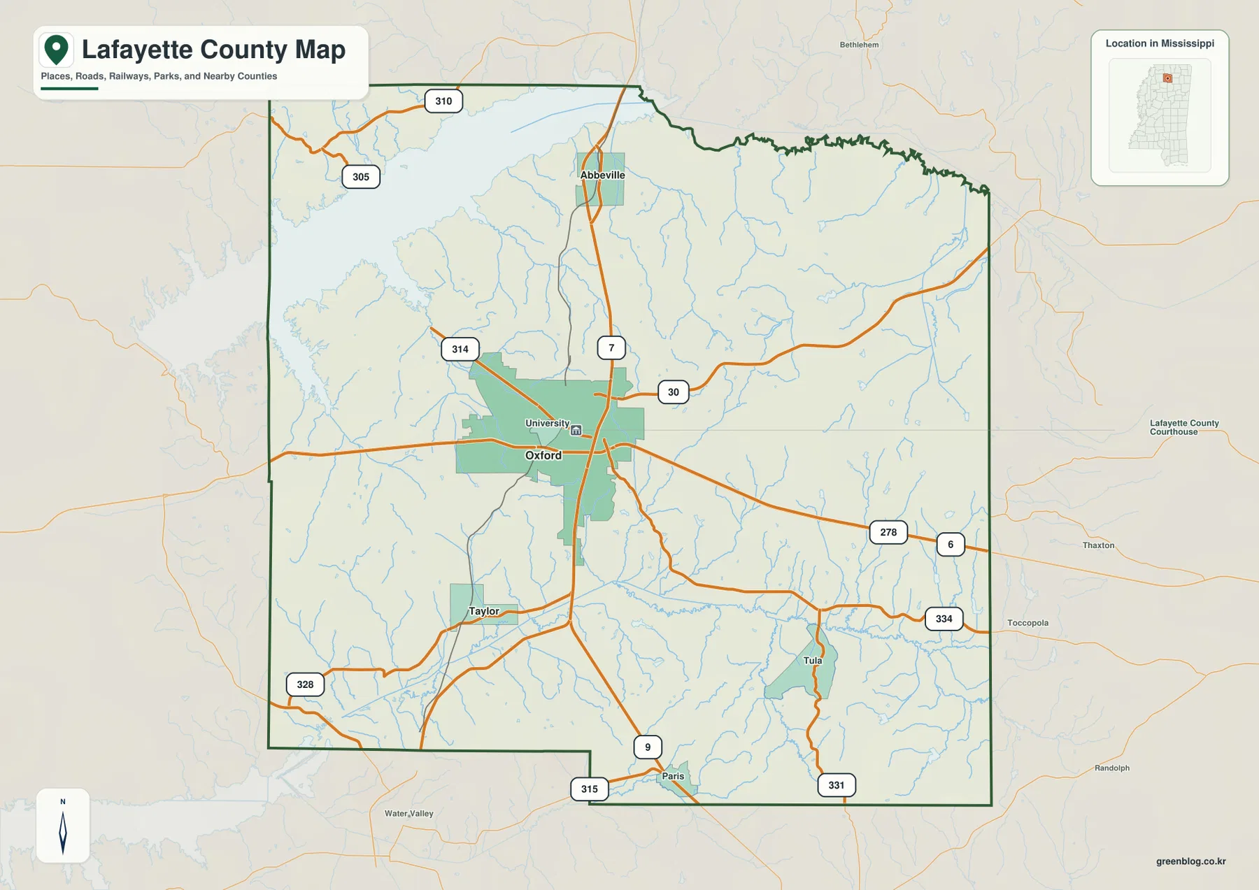
The map also shows a useful set of secondary routes without trying to draw every local road. MS 328 reaches the southwest, while MS 9, 315, 331, and 334 help separate the southern approaches. Routes 305 and 310 appear in the northwest. These road numbers are especially useful when a visitor is trying to identify which side of Oxford a rural place lies on, because the county contains large areas outside the city where road direction is a better locator than a dense cluster of town names.
| Item | Map or source value |
|---|---|
| County seat | Oxford |
| City-map places | Oxford, Abbeville, Taylor |
| 2020 census population | 55,813 |
| July 2025 population estimate | 59,597 |
| 2025 Gazetteer area | 631.697 sq mi land, 47.531 sq mi water |
| 2020 population / land-area density | about 88.4 people per sq mi |
| Elevation-map range | about 75–189 m, mean 117 m |
The population, estimate, and area values use different reference dates, so they are best treated as scale indicators rather than one single-year snapshot. The city map also makes clear that the population is not spread evenly across the 631 square miles of land. Oxford is a much larger center than the other labeled communities, while broad parts of the county remain rural, wooded, or divided by creek valleys.
Oxford, Abbeville, and Taylor on the city map
The city map deliberately keeps the settlement pattern simple. Oxford is marked as the hub with a population of 26,411. Abbeville appears to the north with 311 residents and a direct distance of 11 miles from Oxford, while Taylor lies to the southwest with 245 residents and a direct distance of 6 miles. Those mileage labels are straight-line measurements shown by the map, not driving distances, so road travel may be longer.
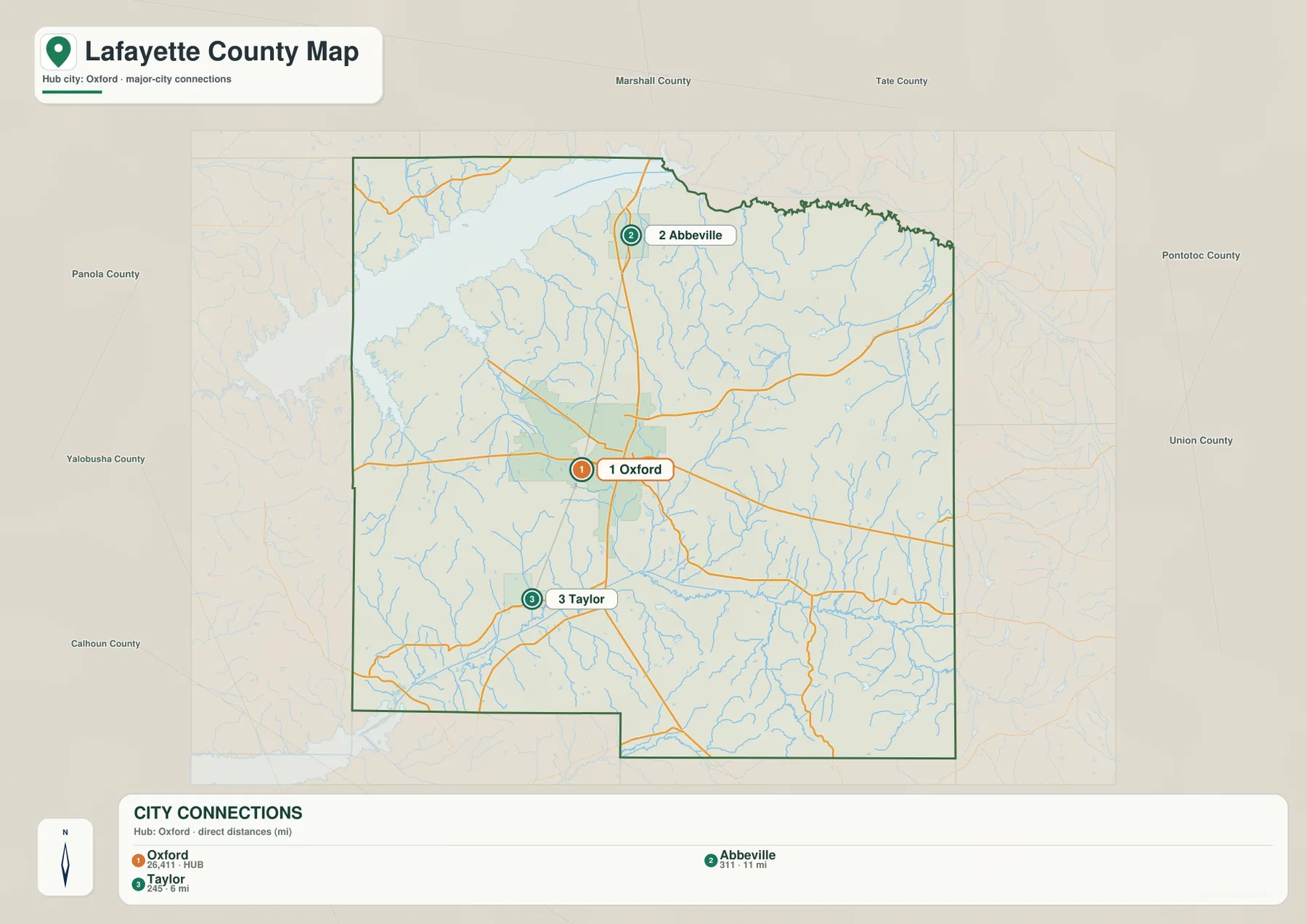
These three places provide a practical way to divide the county. Abbeville points toward the northern side and the eastern approach to Sardis Lake, while Taylor helps locate the southwestern quarter. The map also names surrounding counties around the frame, including Panola, Marshall, Tate, Pontotoc, Union, Calhoun, and Yalobusha. That outer context is useful when Lafayette County is being compared with neighboring map pages or when a route continues beyond the county boundary.
Sardis Lake, the Yocona River, and smaller waterways
Sardis Lake dominates the northwest corner of the water map. Its broad reservoir shoreline is much larger than the smaller lakes elsewhere in the county and creates an immediate contrast with Oxford’s road-centered landscape. The Little Tallahatchie River, Hurricane Creek, and Graham Mill Creek appear across the northern part of the county, while Cypress Creek and lakes such as Bagley Lake and Puskus Lake add more detail to the northeast. The water map shows that the northern half is cut by many small drainage lines even where the county map looks relatively open.
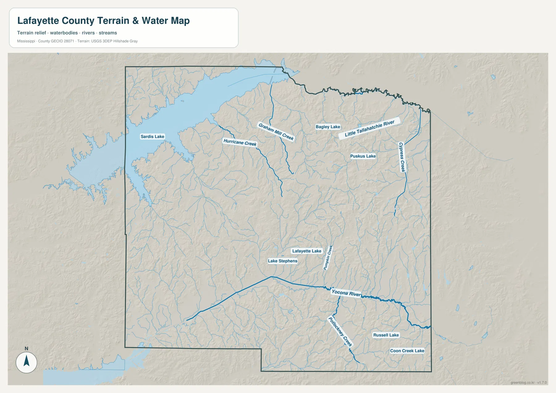
Across the southern half, the Yocona River forms a long east-west low corridor. Potlockney Creek joins the network nearby, and Lake Stephens plus Lafayette Lake appear in the central-southern area. Russell Lake and Coon Creek Lake are labeled farther southeast. These features are useful not only for locating water, but also for understanding the terrain: the main streams occupy lower corridors that become obvious when the water map is compared with the elevation map.
Sardis Lake should not be treated as part of the Oxford urban core. Oxford is the central city and transportation reference, whereas the reservoir is a separate northwest landscape feature. On a presentation or regional map, placing Oxford first and then showing the lake as a second anchor gives a clearer picture of how the county changes from the university-centered city area to reservoir, wooded hills, and creek valleys.
Relief from 75 to 189 meters
The elevation map shows an actual range of about 75 to 189 meters, with a mean of 117 meters. Lower green terrain follows the Sardis Lake area and several stream valleys, while higher yellow-brown ridges are widespread through the central and eastern parts of the county. The surface around Oxford is not flat; numerous short ridges and narrow valleys create a textured pattern. The Yocona River stands out as a lower belt across the south, separating higher ground on either side.
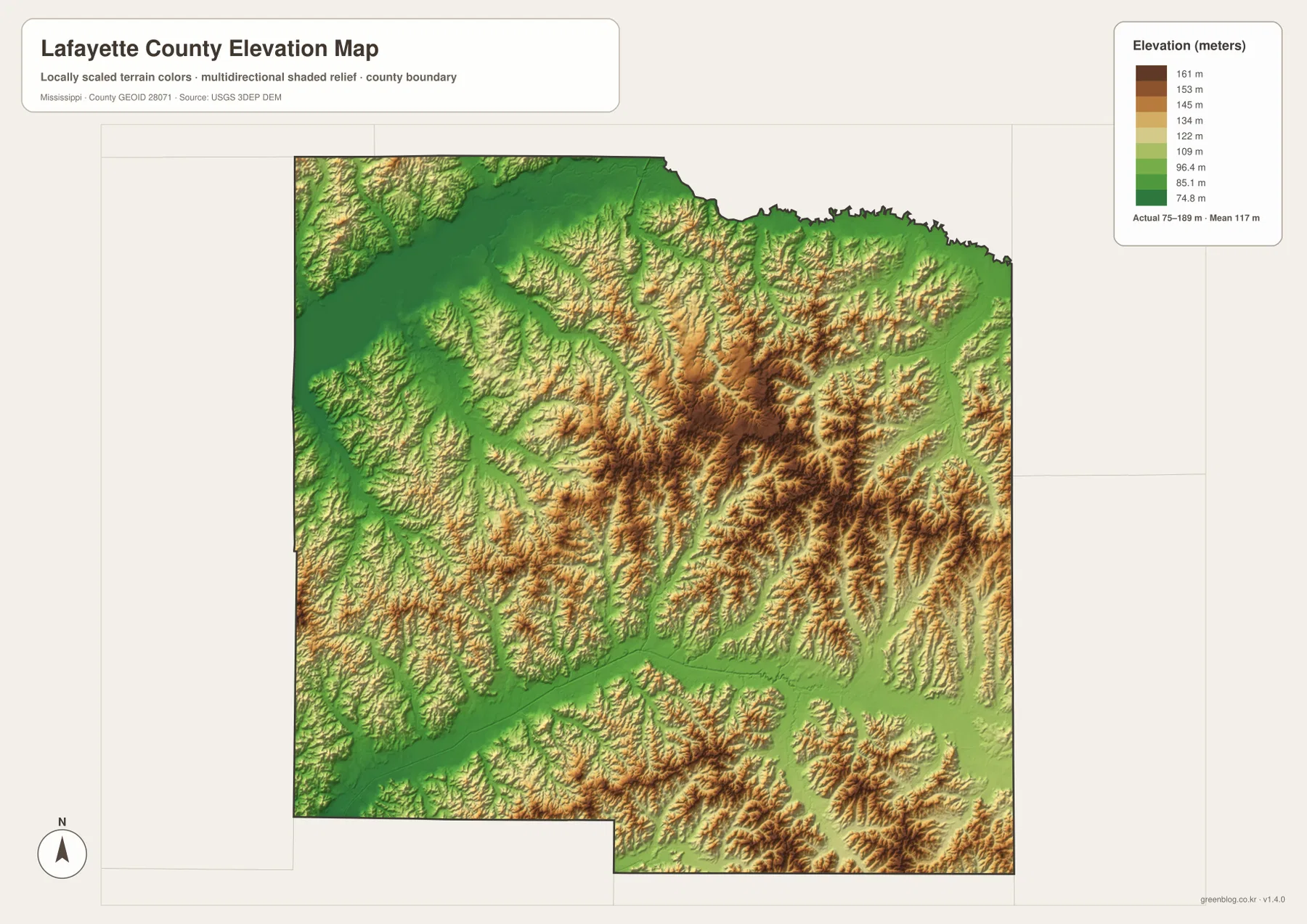
Comparing elevation and drainage explains why the water network is so branched. Creeks follow lower ground between ridges, and the larger river corridors remain visibly lower than the surrounding hills. This map is intended for county-scale comparison, not as a survey of a specific parcel or building site. For a precise point elevation, a more detailed elevation dataset should be used in addition to this overview.
Which map is best for your project?
Use the county map when the main task is to show Oxford, major routes, and the county outline. The city map is cleaner when the focus is the relationship between Oxford, Abbeville, and Taylor. The water map is the better choice for Sardis Lake, the Yocona River, and named creeks, while the elevation map makes the ridge-and-valley terrain easiest to see. Choosing the map that matches the question keeps a slide, worksheet, report, or video graphic from becoming crowded.
The WebP versions in the article are sized for fast web viewing. The download below contains the county, city, water, and elevation maps as high-resolution A3 JPG files. You can download the ZIP once and then use only the map or maps needed for printing, document editing, classroom materials, or visual reference.
Frequently Asked Questions
Is Sardis Lake inside Oxford?
No. The large reservoir lies northwest of Oxford. Oxford works as the central city and road reference, while Sardis Lake is a separate landscape feature in the northwestern part of the county.
Are the 11 mi and 6 mi labels driving distances?
No. The city map labels Oxford to Abbeville as 11 miles and Oxford to Taylor as 6 miles by direct distance. Actual road mileage depends on the route taken.
Is Lafayette County mostly flat?
No. The elevation map ranges from about 75 to 189 meters. Lower terrain follows Sardis Lake and major stream valleys, while higher ridges are common across the central and eastern parts of the county.
Map File Information
Download the county, city, water, and elevation maps together as high-resolution A3 JPG originals.
- Included Files: county map, city map, water map, elevation map
- File Type: JPG
Related Maps
Sources
- U.S. Census Bureau QuickFacts
- U.S. Census Bureau Gazetteer Files
- Mississippi Department of Transportation official highway map
- U.S. Army Corps of Engineers Sardis Lake
Green Map creates custom-edited map images using open geographic data sources such as geoBoundaries, Natural Earth, OpenStreetMap, and government open data. These maps are edited visual materials, not raw data files, and are provided for education, documents, presentations, and graphic reference.