The Lamar County Mississippi Map is easiest to understand from Purvis, the county seat near the eastern half of the county. Sumrall sits well to the northwest, Lumberton marks the southern end, and the Hattiesburg urban area presses against the eastern boundary. Between those places, the maps show a landscape of small streams, wooded ridges, and road corridors rather than one dominant river or lake. You can download the A3 high-resolution JPG versions of the county, city, water, and elevation maps from the file box below.
Table of Contents
Using Purvis to orient the county road network
Purvis provides the clearest starting point on the general county map. US 11 and I-59 run north and south near the city, connecting the Hattiesburg side of the county with Lumberton near the southern boundary. North of Purvis, MS 589 follows a separate route toward the upper part of the county. Farther north, US 98 cuts across the county toward West Hattiesburg, while MS 42 reaches Sumrall near the northwestern edge. MS 44 appears along the western side, and MS 13 approaches the Lumberton area from the west.
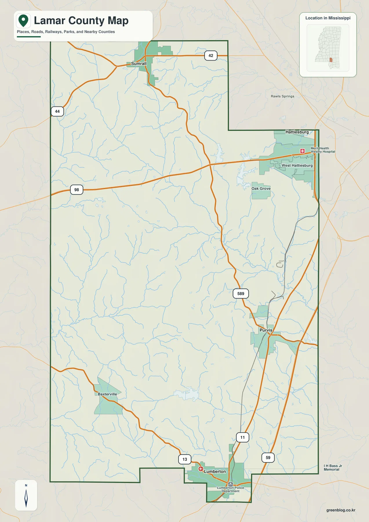
The county outline is useful because Lamar County does not form a simple rectangle. The northeastern side steps around the Hattiesburg area, and the southern boundary has several notches around the Lumberton end. West Hattiesburg and Oak Grove appear close to the eastern edge, making the metropolitan side visually different from the more rural interior. Baxterville is shown in the southwest, while Sumrall is separated from Purvis by a broad area crossed by streams and local roads. This map is best for regional orientation, not turn-by-turn navigation.
| Item | County reference |
|---|---|
| County seat | Purvis |
| Primary city-map labels | Purvis, Sumrall, Lumberton |
| 2020 census population | 64,222 |
| July 2025 population estimate | 67,403 |
| 2025 Gazetteer area | 496.570 sq mi land, 3.425 sq mi water |
| 2020 population divided by land area | about 129.3 residents per sq mi |
| Elevation-map range | about 50–139 m, mean 96 m |
The population and area figures give scale to the county but should not be read as a picture of uniform settlement. The 2020 census count and the July 2025 estimate come from different dates, and the calculated density is only a countywide average. The maps make the uneven pattern much clearer: development is more visible near the Hattiesburg side and around Purvis, while large stretches to the west and southwest are broken up by woods, creeks, and smaller communities.
Purvis, Sumrall, and Lumberton on the city map
The city-connections map strips away most secondary labels and uses Purvis as the hub. Purvis is listed at 1,914 residents. Sumrall, shown northwest of the hub, is listed at 1,674 and about 20 miles away in straight-line distance. Lumberton lies south of Purvis, is listed at 1,320, and is about 10 miles from the hub by the same straight-line measure. Those mileage labels are not driving distances; actual road travel will be longer and depends on the route used.
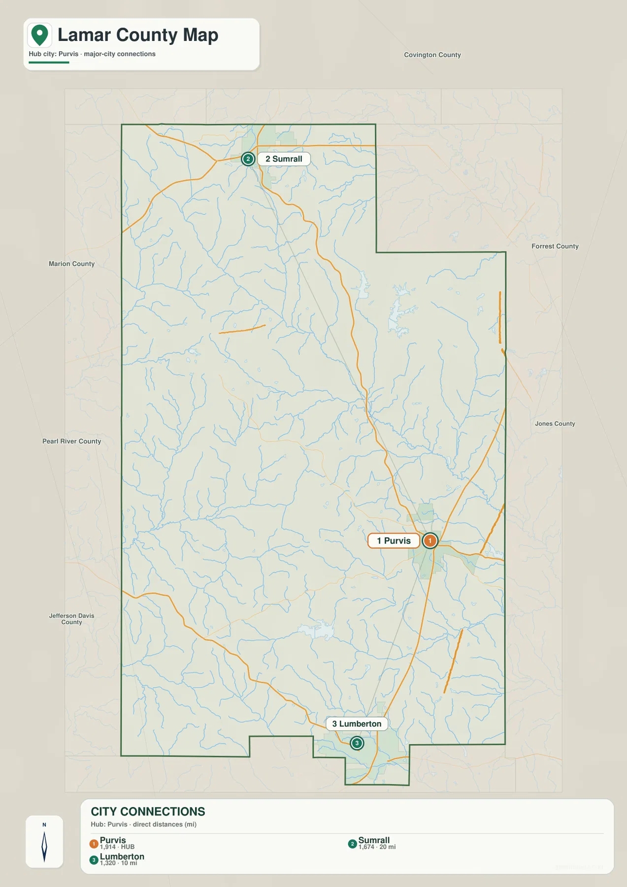
This simplified layout also explains the county’s elongated north-south shape. Sumrall is close to the northwestern edge rather than directly above Purvis, while Lumberton sits near the southern boundary. Purvis is shifted eastward between them, close to the I-59 corridor and the Hattiesburg side of the county. Neighbor labels around the map include Covington County to the north, Forrest County to the east, Pearl River County to the south, and Marion and Jefferson Davis counties to the west. Together they place Lamar County within the broader Piney Woods region of southern Mississippi.
Black Creek, small lakes, and the county’s drainage network
The terrain-and-water map reveals a much denser network than the road map. Black Creek enters the northwestern part of the county and follows a long, winding valley toward the interior. Gully Creek is prominent farther west, while Mill Creek and Mixons Creek appear across the central and eastern portions. Little Black Creek crosses the southeastern part of the county. Numerous unnamed tributaries fill the spaces between them, giving the county a branching pattern of narrow valleys.
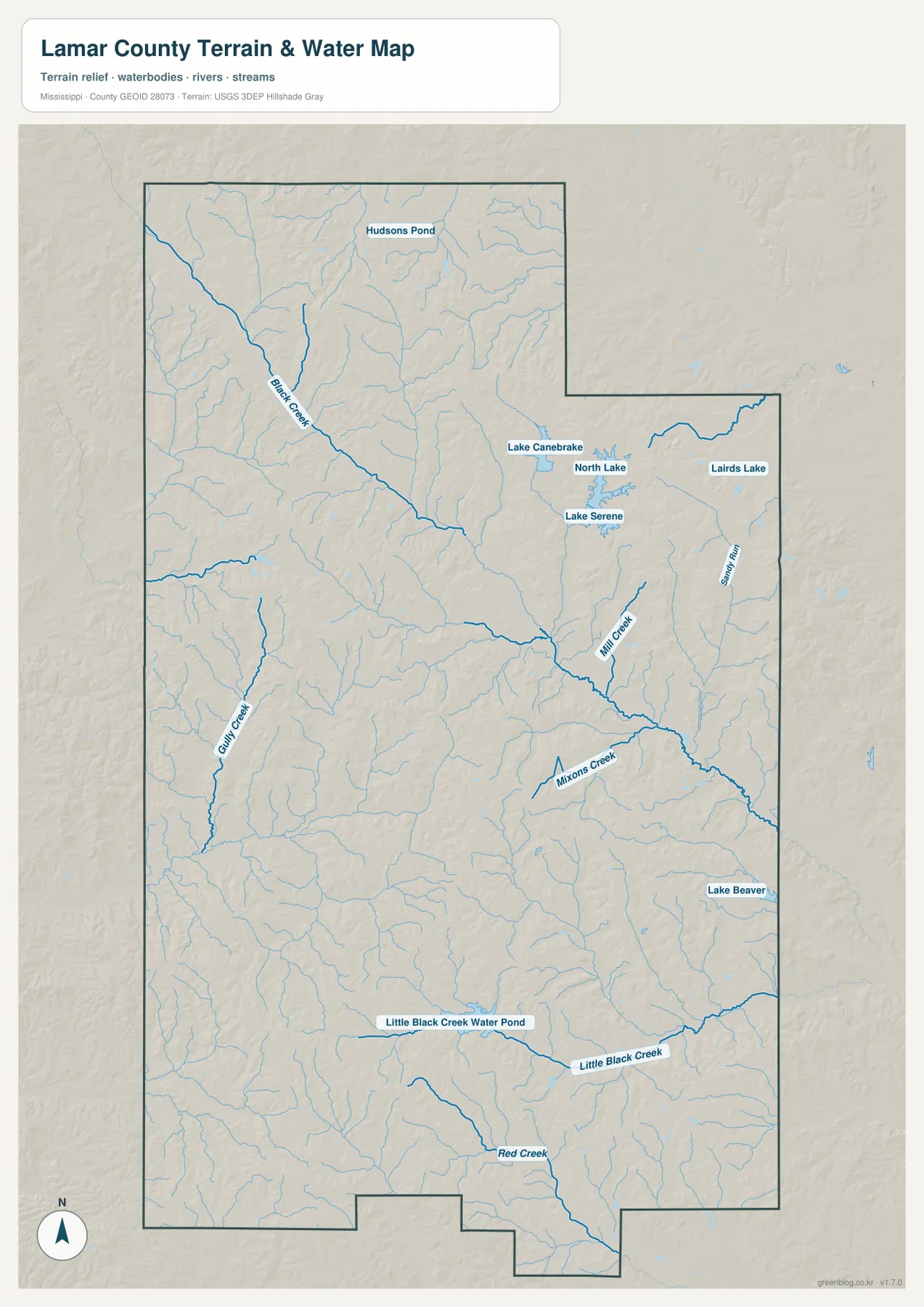
Several named lakes are concentrated in the northeastern part of the county. Lake Canebrake, North Lake, Lake Serene, and Lairds Lake sit relatively close together, while Hudsons Pond appears farther north. Lake Beaver is labeled toward the southeast. The southern part of the map also identifies Little Black Creek Water Pond and Red Creek. Water accounts for only a small share of the county’s total area, yet these streams and small lakes are widely distributed enough to matter when locating low ground, local watersheds, and natural corridors.
Black Creek is especially useful as a reference because its valley can be compared directly with the elevation map. The creek occupies a long band of lower ground, and the smaller tributaries branch into similar low corridors. Between those valleys are narrow uplands and ridges. That relationship explains why the relief map looks much more textured than a casual glance at the general road map might suggest.
A 50–139 m landscape of ridges and creek valleys
The elevation map gives an actual county range of about 50 to 139 meters, with a mean of 96 meters. Brown and tan bands mark higher ridges across much of the west, northwest, and interior. Green corridors trace lower land along the creek valleys, producing a repeated pattern of narrow lows between higher ground. Lamar County is not mountainous, but it is also not a featureless plain; the local relief is made up of many small rises and incised drainage lines.
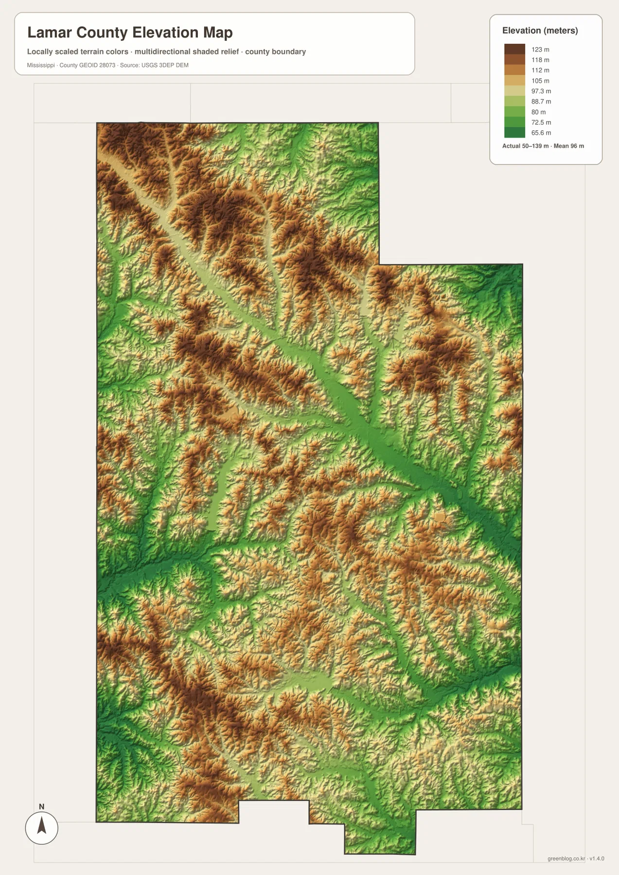
The same pattern continues near Purvis and toward the Hattiesburg side. Roads often cross or follow lower corridors between the ridges, while the southern part toward Lumberton contains another mix of creek bottoms and higher wooded ground. For classroom or regional-reference use, this map is useful for explaining why watercourses wind through the county and why the landscape has so many short ridges. It is a county-scale relief map, however, not a survey of exact elevations for individual lots or structures.
Which Lamar County map fits the task?
Use the county map when the main question is where Purvis, Sumrall, Lumberton, West Hattiesburg, and the major roads sit in relation to the county boundary. The city map is cleaner when you only need the three principal city labels and their straight-line distance from Purvis. Choose the water map for Black Creek, smaller creeks, lakes, and drainage context. The elevation map is the clearest option for showing the difference between low creek valleys and the surrounding ridges. Selecting the map by purpose keeps the visual simple instead of forcing every layer onto one page.
The WebP images in the article are optimized for quick viewing. The downloadable ZIP contains the county, city, water, and elevation maps as high-resolution A3 JPG files. That set is better suited to printing, document layout, classroom materials, or other work where the original image dimensions matter.
Frequently Asked Questions
Is the 20-mile Purvis-to-Sumrall label a driving distance?
No. The city map uses straight-line distance between the two locations. A road trip will be longer and will vary with the route chosen.
What stands out on the Lamar County water map?
The county has a widespread network of creeks rather than one dominant lake. Black Creek, Gully Creek, Mill Creek, Mixons Creek, and Little Black Creek are among the clearest labels, with several small lakes concentrated in the northeast.
Is Lamar County mostly flat?
The county has no high mountains, but the elevation map shows frequent ridges and creek valleys within an actual range of about 50–139 meters. The lower green corridors follow many of the same drainage lines visible on the water map.
Map File Information
Download the Lamar County county, city, water, and elevation maps together as high-resolution A3 JPG files.
- Included Files: County map, city map, water map, elevation map
Related Maps
Sources
- U.S. Census Bureau QuickFacts
- U.S. Census Bureau Gazetteer Files
- Mississippi Department of Transportation official highway map
- Longleaf Trace
Green Map creates custom-edited map images using open geographic data sources such as geoBoundaries, Natural Earth, OpenStreetMap, and government open data. These maps are edited visual materials, not raw data files, and are provided for education, documents, presentations, and graphic reference.