A Yazoo County Map becomes much easier to understand once you notice that the county crosses two very different landscapes. West of Yazoo City, broad low ground follows the Yazoo River and contains numerous lakes and wet channels. East of the city, the land rises quickly into deeply cut hills where narrow creeks occupy the valleys. This page uses the supplied county, city-connection, water-and-terrain, and elevation maps to explain those contrasts in plain language. High-resolution A3 JPG versions of all four maps are also available together in the ZIP download box below.
Yazoo City is the most useful starting point, but the county is far too large to describe through one city alone. Eden lies to the north, Bentonia to the south, Satartia in the southwest, and Benton to the east. US 49, MS 3, MS 16, MS 149, MS 432, and MS 433 connect different parts of a county whose shape reaches from flat floodplain country into rolling and sharply dissected uplands. Looking at the road map first gives you orientation; the water and elevation maps then explain why the western and eastern halves look and feel so different.
Table of Contents
Yazoo City as the road reference point
The general county map places Yazoo City near the center of the main road network. US 49 passes through the city and continues south toward Bentonia, while MS 149 approaches from the west. MS 432 and MS 16 extend toward the eastern side of the county, and the southwest is reached through routes including MS 3 and MS 433. Yazoo County Airport is marked just west of the city, which adds another easy landmark when you are trying to orient yourself on the map.
The surrounding towns fall into clear directions from that hub. Eden is north of Yazoo City, Bentonia is south along the US 49 corridor, Satartia sits much farther southwest in the lowland portion of the county, and Benton appears to the east where the terrain becomes hillier. This arrangement is more useful than memorizing road numbers in isolation. Start with Yazoo City, then divide the county into the Eden, Bentonia, Satartia, and Benton directions; the irregular boundary and long east-west span become much easier to follow.
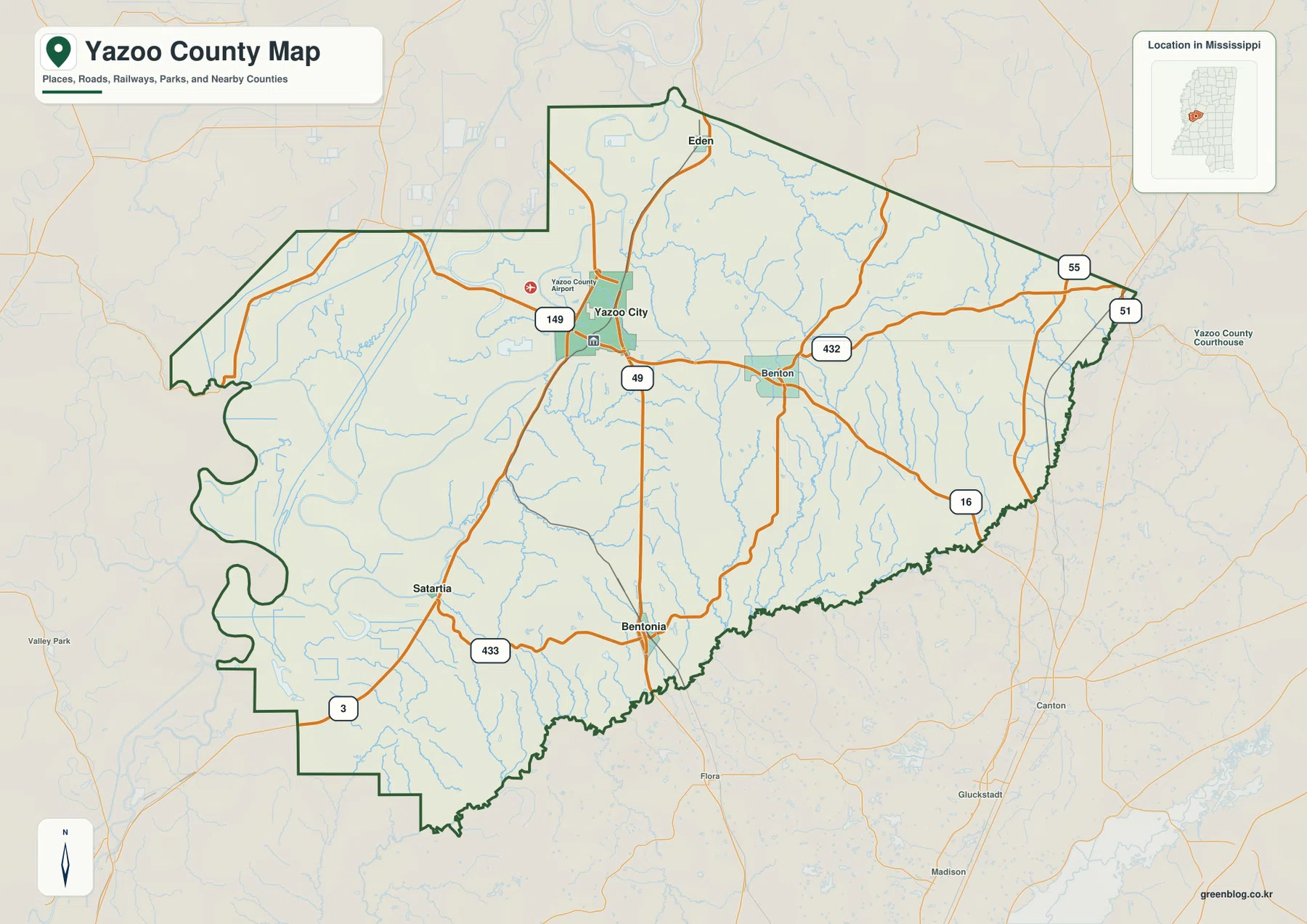
The county boundary itself also hints at the terrain. The western edge contains several broad curves and indentations, while the northern and eastern sides include longer straight or diagonal segments. The southern edge is more irregular. On its own, that outline is simply an administrative boundary, but the other maps add meaning: the most sinuous western margin sits beside the low floodplain landscape, whereas the interior rises toward the eastern hills. Using the maps together helps separate what is a legal boundary from what is a river, valley, road, or change in elevation.
How far Eden, Bentonia, and Satartia sit from Yazoo City
The city-connection map uses Yazoo City as the hub and gives direct distances to three other marked communities. Eden is shown about 9 miles away, Bentonia about 15 miles, and Satartia about 16 miles. These are straight-line distances rather than driving distances. A road trip can be longer because highways curve, crossings are limited, and a route may have to follow the road network around water or terrain. The numbers are best used to compare relative spacing inside the county, not to predict travel time.
The outer labels add regional context. Holmes and Humphreys Counties lie to the north, Sharkey County to the west, Warren and Issaquena Counties to the southwest, and Madison and Hinds Counties to the east and southeast. That arrangement makes Yazoo City an especially useful orientation point because it sits between Delta lowlands to the west and higher country to the east. Satartia is visibly closer to the lowland side, while places east and northeast of Yazoo City are associated with a more broken terrain.
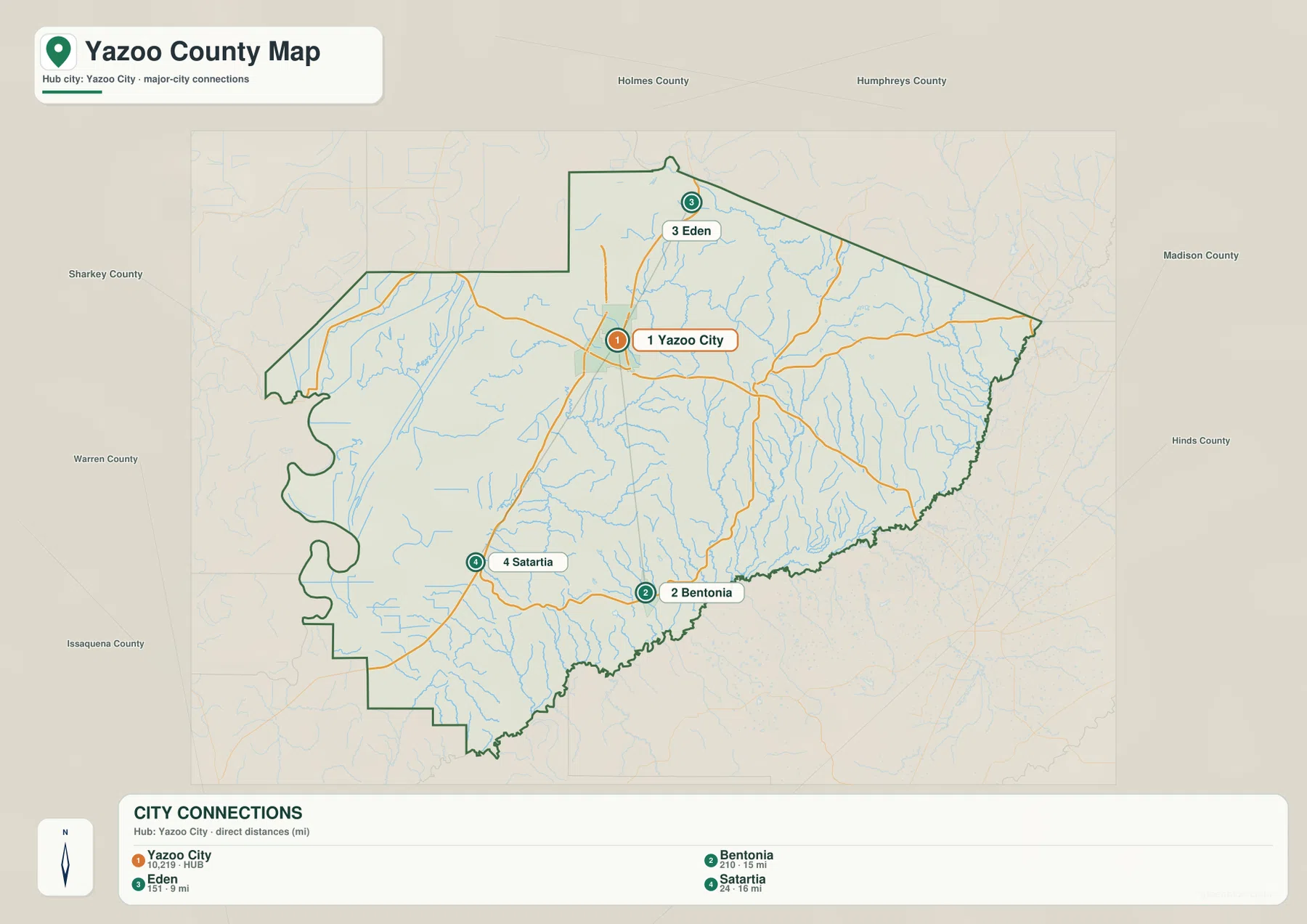
The map also makes clear that population is not spread evenly across the county. The named communities are separated by wide rural areas, and the western portion includes extensive lowlands with water, wetlands, and agricultural land between settlements. Yazoo City is the main urban reference point, but the county as a whole is a large rural landscape. That is why a single population-density number cannot describe what the ground looks like from one part of Yazoo County to another.
The low western floodplain: Yazoo River, lakes, and wet channels
The water-and-terrain map shows the western half of Yazoo County in far greater detail than the road map. The Yazoo River bends through the central-western part of the county, and several named water bodies appear across the low ground. Broad Lake, Lake George, Fish Lake, Dump Lake, and Johnson Lake are among the labels visible on the supplied map. Rather than one simple river corridor, the west contains a broad network of low areas, curving channels, and scattered lakes that gives the floodplain a distinctive appearance.
Moving east changes the shape of the drainage. Piney Creek, Short Creek, Cypress Creek, and other branches run through narrower valleys, while the Big Black River is labeled near the southern boundary. The contrast is striking: western water features occupy broad, flat lowland, whereas eastern creeks are threaded between ridges. This is one of the most county-specific lessons in the map set. The same county includes both Delta-style floodplain scenery and a much more dissected upland drainage pattern.
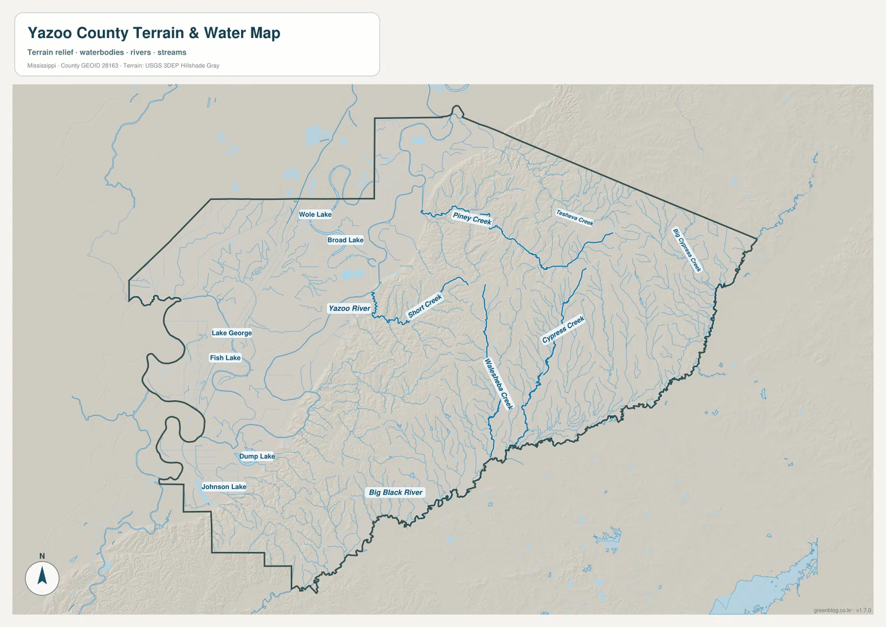
Panther Swamp National Wildlife Refuge, preserved in the package as an official regional reference, is useful for understanding the western lowland environment. The refuge should not be treated as if its legal boundary were drawn by this county water map; the map is intended to show county-scale terrain and water features, not property limits, flood zones, or access rules. For current refuge information, the U.S. Fish and Wildlife Service link in the sources section is the appropriate reference.
From about 20 to 116 meters: a sharp west-to-east rise
The elevation map lists an actual range of about 20 to 116 meters, with a mean near 58 meters. Those numbers become much more meaningful when viewed spatially. The western side is dominated by dark green low terrain that appears broad and comparatively smooth. Near the middle of the county, that low surface gives way quickly to yellow, tan, and brown ridges. The eastern and northeastern portions are cut by numerous short valleys, creating a rugged texture that is almost absent from the broad floodplain.
The water map explains the same transition from another angle. Yazoo River and the cluster of western lakes occupy the lowest country, while Piney Creek and Cypress Creek follow valleys between higher ridges to the east. Along the south, the Big Black River sits in lower terrain, but nearby ground rises again into hills. Roads cross these changes without making them obvious on a simple street map, so the elevation layer is especially useful for understanding why a route that looks straight on paper can pass through very different landscapes.
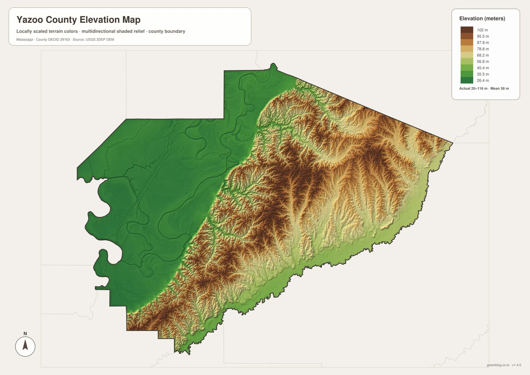
This elevation map is not a survey drawing or a substitute for site-specific engineering data. It is best used at county scale to compare relative high and low areas. For a visitor, student, writer, or map user, that is enough to answer a basic but important question: where does Yazoo County stop looking like a flat Delta landscape and begin looking like hill country? The transition is not primarily north-to-south; it is most obvious as you move from the western lowlands toward the center and east.
County size, population, and what an average density can hide
The preserved Census information in the package gives Yazoo County a 2020 Census population of 26,743 and a July 2025 population estimate of 22,947. The 2025 Gazetteer figures list 922.339 square miles of land and 11.820 square miles of water. Dividing the 2020 population by the 2025 land-area figure gives a countywide average of about 29.0 residents per square mile. These figures help establish scale: this is a very large county with substantial rural territory between its named communities.
| Item | Value preserved in the package | What to compare on the maps |
|---|---|---|
| County seat | Yazoo City | Main road hub around US 49 and several state routes |
| 2020 population | 26,743 | Wide spacing between communities and large rural areas |
| July 2025 estimate | 22,947 | A different reference date from the 2020 Census |
| Land / water area | 922.339 / 11.820 sq mi | Large interior area plus rivers, lakes, and wet lowland |
| Elevation | About 20–116 m; mean about 58 m | Strong contrast between western flats and eastern hills |
The 29.0-per-square-mile figure does not mean Yazoo City, Bentonia, Eden, Satartia, farmland, forest, and wetland all contain the same number of people per square mile. It is a single average across the county’s land area. The maps show why that distinction matters: settlement points are separated by broad stretches of rural land, and the western floodplain differs substantially from the eastern hills. Use the statistics to understand overall scale, then use the maps to understand where roads, towns, water, and terrain actually occur.
Which Yazoo County map should you use?
For a fast location check, start with the general county map. It is the best choice for finding Yazoo City, Eden, Bentonia, Satartia, Benton, the county boundary, and the principal numbered roads. If you need a sense of spacing rather than route detail, switch to the city-connection map. Its direct-distance labels make it easy to compare how far Eden, Bentonia, and Satartia sit from Yazoo City and to see which neighboring counties lie around the perimeter.
Choose the water-and-terrain map when your question involves rivers, lakes, creeks, or the low western floodplain. It places the Yazoo River and western lakes in the same frame as eastern creek valleys and the Big Black River. Use the elevation map when the main question is relief: the color ramp makes the low western plain and higher eastern hills immediately visible. Looking at those two maps together is the quickest way to understand the county’s strongest physical contrast.
The WebP images on this page are optimized for quick viewing in a browser. If you need files for printing, editing, a presentation, or offline reference, use the ZIP below instead of saving the previews. It contains the same four subjects as high-resolution A3 JPG files, so you can keep the road, city, water, and elevation views together.
Frequently Asked Questions
Why do western and eastern Yazoo County look so different on the elevation map?
The western side is a broad, low floodplain, while the center and east rise into much more deeply dissected hills. The supplied elevation map ranges from about 20 to 116 meters and shows that transition clearly. The water map reinforces it: western lakes and the Yazoo River occupy low terrain, while eastern creeks run through narrower valleys between ridges.
Are the 9-, 15-, and 16-mile labels driving distances?
No. The city-connection map uses direct distances from Yazoo City: about 9 miles to Eden, 15 miles to Bentonia, and 16 miles to Satartia. Driving distances can be longer because roads do not always follow a straight line and crossings or turns can change the route. Use the labels to compare relative spacing, not as turn-by-turn travel distances.
Does this map show the official Panther Swamp refuge boundary?
No. The water-and-terrain map is a county-scale reference for rivers, lakes, creeks, and terrain. It should not be used to determine refuge property lines, access rules, or flood-zone boundaries. For current Panther Swamp information, use the U.S. Fish and Wildlife Service link in the sources section.
Map File Information
The page uses lightweight WebP previews for quick viewing. The ZIP below contains four high-resolution A3 JPG originals for printing, editing, and offline reference.
- File Type: ZIP containing 4 JPG files
Related Maps
Sources and References
Population, area, road context, and the Panther Swamp reference are based on the official links preserved in the package and the supplied map images. Use the original agency pages below when you need the latest statistics, road information, or refuge guidance.
- U.S. Census Bureau QuickFacts for Yazoo County
- U.S. Census Bureau 2025 Gazetteer Files
- Mississippi Department of Transportation official highway map
- U.S. Fish and Wildlife Service Panther Swamp information
Green Map creates custom-edited map images using open geographic data sources such as geoBoundaries, Natural Earth, OpenStreetMap, and government open data. These maps are edited visual materials, not raw data files, and are provided for education, documents, presentations, and graphic reference.