Lawrence County, Mississippi, is easiest to understand by starting with Monticello and then following the Pearl River through the middle of the county. New Hebron provides a northeastern reference point, while Silver Creek lies east of Monticello near the county’s eastern side. The supplied maps separate the major roads and county outline from city connections, waterways, and elevation, so the same area can be viewed without crowding every detail into one image. The A3 high-resolution JPG versions of the county, city, water, and elevation maps are also available together as a ZIP download.
Table of Contents
Monticello as the road reference for Lawrence County
Monticello sits near the center of the county and provides the clearest starting point for reading the road map. US 84 crosses the county from west to east through the Monticello area, while MS 27 turns south and helps define the route toward the southern part of Lawrence County. Farther northeast, New Hebron appears near MS 42. Silver Creek is east of Monticello, and the map also shows MS 43 along the eastern and southeastern side and MS 44 near the southwestern boundary. These routes give the county a set of recognizable directions even before the smaller local roads are considered.
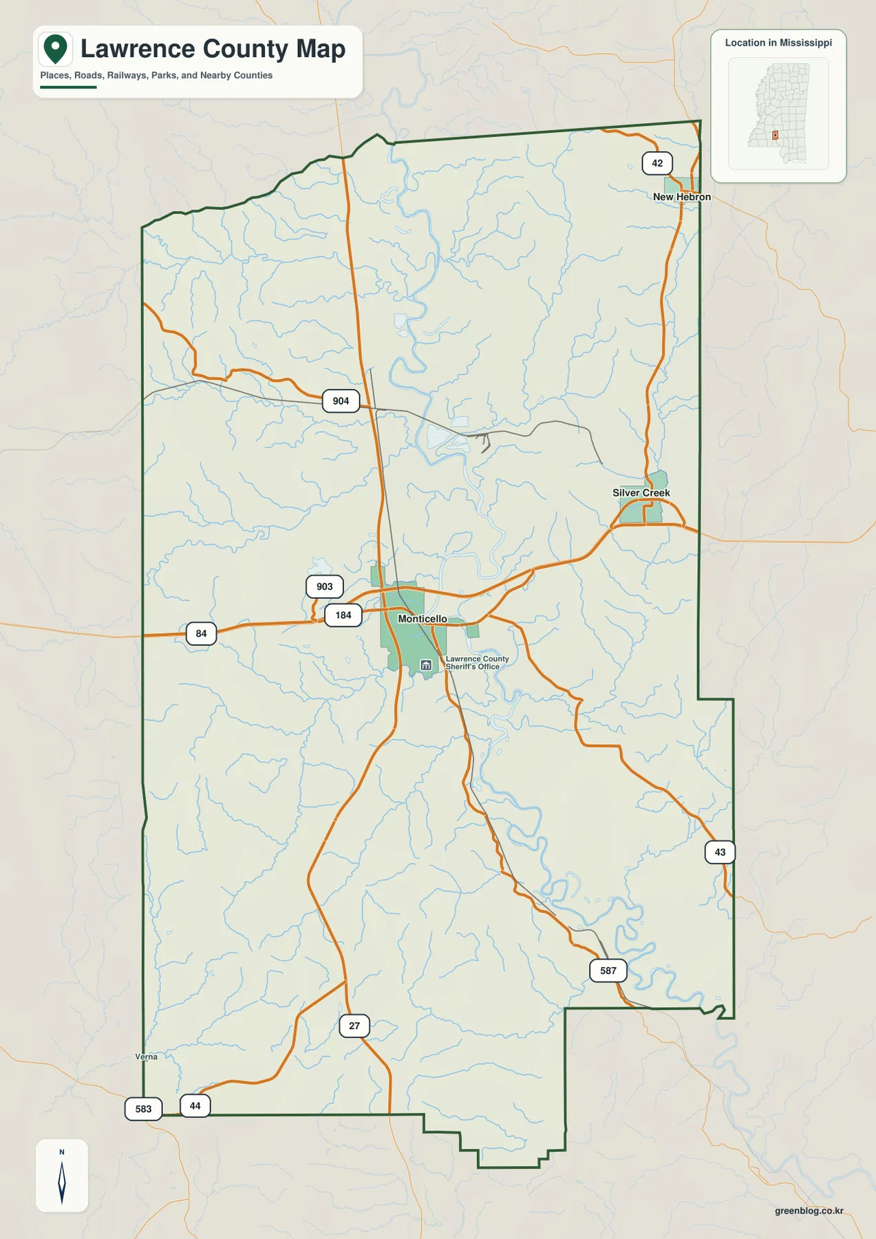
The county outline is not a simple rectangle. Its eastern side changes shape in the middle and lower portions, and the southern boundary has several steps and turns. The Pearl River becomes increasingly noticeable south of Monticello, where its bends occupy a broad low corridor. Roads cross or skirt those low areas rather than following a uniform grid, so the map is most useful for county-scale orientation: where the main towns sit, which direction the principal highways run, and how the administrative boundary fits around the river landscape.
| Item | Value shown or supported by the supplied material |
|---|---|
| County seat | Monticello |
| Primary city-map labels | Monticello, New Hebron, Silver Creek |
| 2020 census population | 12,016 |
| July 2025 population estimate | 11,819 |
| 2025 Gazetteer area | 430.602 sq mi land; 5.092 sq mi water |
| 2020 population divided by 2025 land area | About 27.9 residents per sq mi |
| Elevation map range | About 44–160 m; mean 94 m |
The population figures are useful for scale, but they should not be read as evidence that people are evenly spread across the county. The 2020 census and July 2025 estimate also refer to different dates. The maps themselves show why a countywide average can hide local differences: Monticello is the most prominent town and road junction, while large areas away from the main routes are occupied by wooded uplands, stream valleys, and smaller settlements.
New Hebron and Silver Creek relative to Monticello
The city-connections map strips away much of the road detail and uses Monticello as the hub. It labels Monticello with a population of 1,351, New Hebron with 506, and Silver Creek with 175. New Hebron is shown about 14 miles from Monticello in a straight line, while Silver Creek is about 7 miles away. Those distances are connector distances between mapped points, not driving distances. A road trip will normally be longer because the route must follow the available highway network.
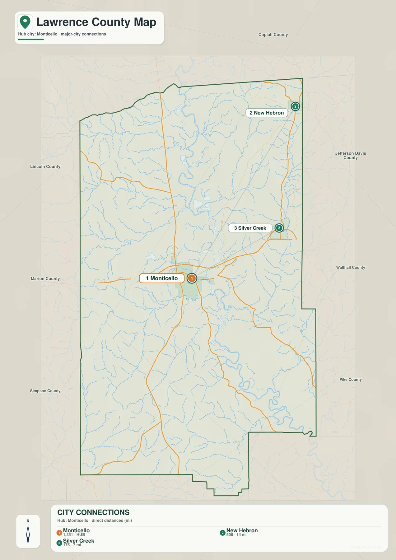
This simplified view makes the settlement pattern clearer. Monticello occupies the central position and is the easiest place from which to judge the rest of the county. Silver Creek is closer and lies to the east, while New Hebron is farther away toward the northeast. The three labels also show that Lawrence County is not organized around a dense chain of towns. Instead, a small number of named communities are separated by broad rural areas, making the road map and city map useful for different purposes.
Pearl River, tributary creeks, and small lakes
The terrain-and-water map makes the Pearl River the dominant geographic feature. It enters from the north, continues through the central part of Lawrence County, and then bends toward the southeast. Several named streams approach it from both sides. Bahala Creek crosses the northwestern part of the county, Bear Creek runs farther south, and Fair River approaches from the west-central side. Hills Creek is prominent south of Monticello, while Silver Creek and smaller channels drain the eastern side. Together they explain why the river corridor is much broader than a single blue line on the county map.
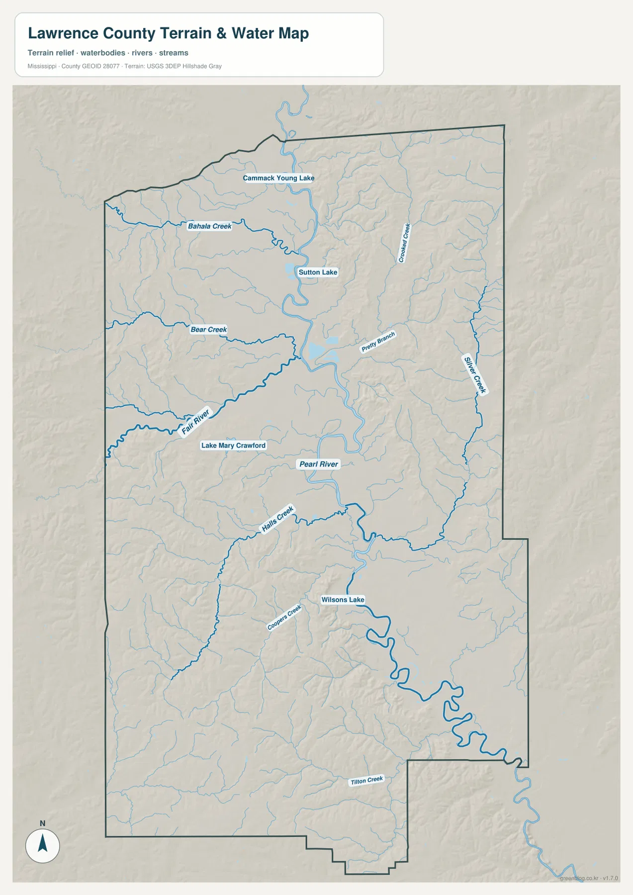
Several smaller water bodies are also labeled. Cammack Young Lake and Sutton Lake appear in the northern half of the county, Lake Mary Crawford lies west of the Pearl River in the central area, and Wilsons Lake is farther south. Crooked Creek and Pretty Branch are labeled on the eastern side, while Cooper Creek and Tilton Creek appear farther south and southwest. These names are useful when a reader needs more than the principal river, but the map should still be treated as a county reference map. It is not a flood-risk map, navigation chart, parcel survey, or source for water depth.
The water map becomes more informative when it is compared with the elevation map. The Pearl River and many tributaries occupy green, lower ground, while the ridges between drainage lines rise into lighter and darker brown terrain. South of Monticello, the river meanders across a wider low area before continuing toward the southeastern edge of the county. That contrast helps explain why some roads remain on higher ground and why the county’s surface looks more broken away from the broad river bottom.
A 44–160 meter range from river bottom to rolling uplands
The elevation map shows an actual range of about 44 to 160 meters and a countywide mean of 94 meters. The broadest low area follows the Pearl River through the center and into the southeast. Higher ground is much more extensive in the southwest, where closely spaced ridges and short valleys create a strongly textured surface. The northeastern and eastern portions also contain substantial higher terrain, interrupted by lower stream valleys that cut back toward the main river system.
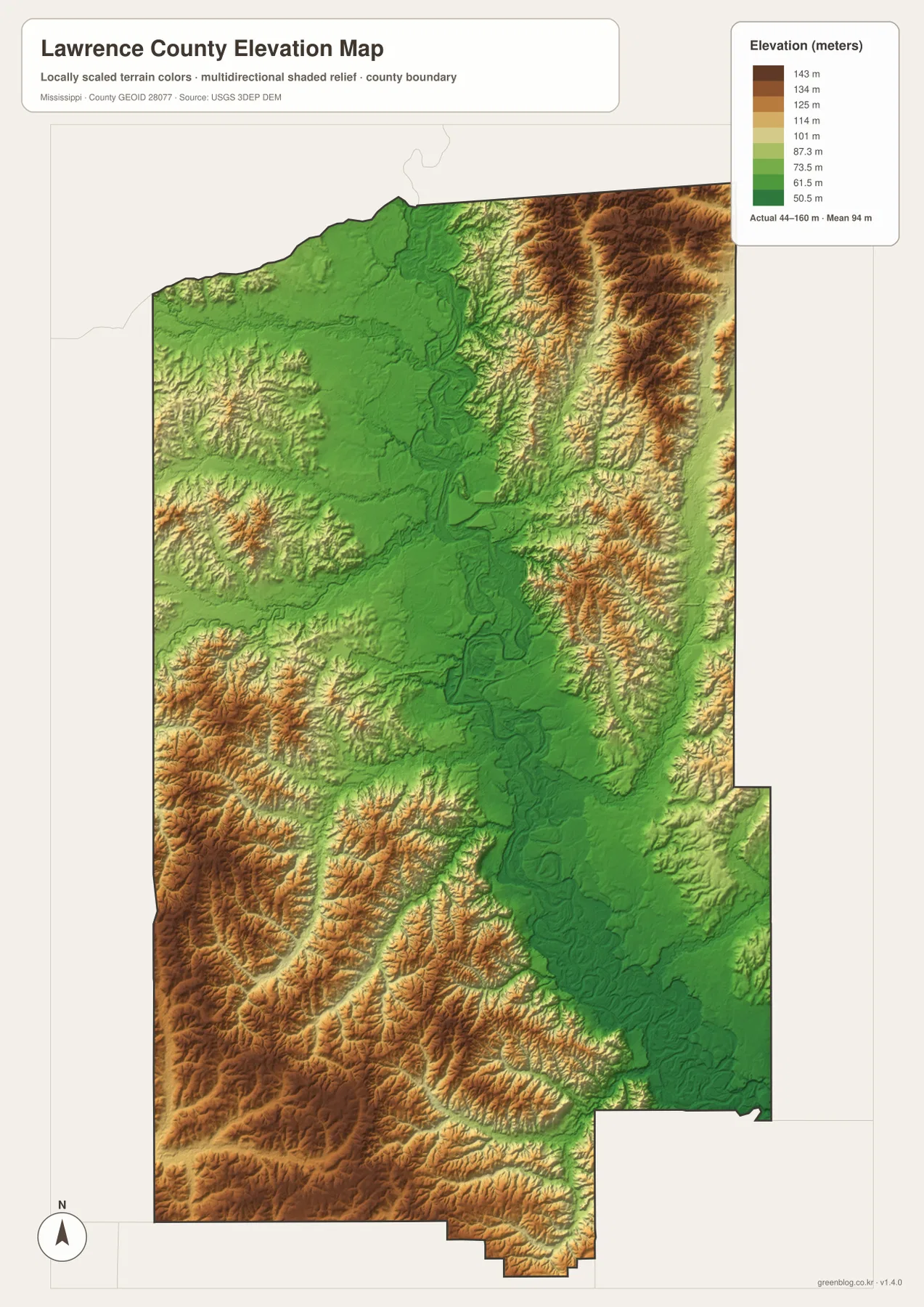
The map does not show a mountainous county, but it does show that Lawrence County is far from uniformly flat. Ridges in the southwest stand well above adjacent stream valleys, while the river corridor forms a long low strip through the middle. Even the northeastern high ground is cut by narrow drainage lines. This generalized elevation surface is appropriate for understanding countywide relief, but it is not survey-grade elevation data for a building site, road design, or engineering decision.
Choosing the map that matches the question
For a quick explanation of Monticello, New Hebron, Silver Creek, and the main highway directions, the county map is the best starting point. The city map is cleaner when the only goal is to compare the three main labeled communities and their straight-line spacing. Anyone looking for Pearl River, Fair River, named creeks, or small lakes will get more detail from the water map. The elevation map is the clearest choice for comparing the low river bottom with the higher southwestern and northeastern uplands. Using the maps separately keeps each task readable rather than forcing roads, water, population labels, and relief into one crowded image.
The WEBP images in the article are optimized for viewing on the page. The downloadable ZIP contains the matching county, city, water, and elevation maps as high-resolution A3 JPG files. That set is better suited to printing, placing the maps in documents or presentations, or enlarging labels and terrain details beyond the on-page preview.
Frequently Asked Questions
Is the 14-mile distance from Monticello to New Hebron a driving distance?
No. The city map uses a straight-line connector between the mapped points. A driving route must follow actual roads, so its mileage can be longer.
Where does the Pearl River run through Lawrence County?
The river enters from the north, passes through the central part of the county, and then curves southeastward. Its broad low corridor is especially easy to recognize south of Monticello on the water and elevation maps.
Is Lawrence County mostly flat?
The Pearl River bottom is relatively low, but the county also contains extensive rolling uplands. The supplied elevation map ranges from about 44 to 160 meters and shows notably higher terrain in the southwest and northeast.
Map File Information
Download the Lawrence County county, city, water, and elevation maps together as high-resolution A3 JPG files.
- Included Files: County map, city map, water map, elevation map
- File Type: JPG
Related Maps
Sources
- U.S. Census Bureau QuickFacts
- U.S. Census Bureau Gazetteer Files
- Mississippi Department of Transportation official highway map
- USGS National Hydrography
- USGS 3D Elevation Program
Green Map creates custom-edited map images using open geographic data sources such as geoBoundaries, Natural Earth, OpenStreetMap, and government open data. These maps are edited visual materials, not raw data files, and are provided for education, documents, presentations, and graphic reference.