Carthage is the clearest starting point for reading Leake County, Mississippi. MS 16 crosses the middle of the county, MS 35 runs through the central area toward Walnut Grove, and smaller state routes branch toward the eastern, western, and southern parts of the county. This page combines those road and settlement references with Pearl River waterways and elevation, and the full A3 high-resolution JPG map files can be downloaded as a ZIP near the end of the article.
The county is not a broad, flat surface. Long low valleys follow rivers and creeks, while rolling higher ground fills much of the space between them. Looking at the road, city, water, and elevation views together makes it easier to understand why Carthage works as a central reference, how Walnut Grove and Lena sit in different directions, and where the major drainage corridors cut through the hills.
Table of Contents
Carthage and the roads that organize Leake County
The general county map places Carthage near the center of a network rather than at the end of one dominant route. MS 16 is the strongest east-west reference through the middle, while MS 35 provides a north-south line through Carthage and continues toward Walnut Grove. On the western side, MS 43 is easy to identify, and the southwest includes MS 25 and MS 13. Farther south, MS 500 connects into the local road pattern, while the eastern and southeastern side shows routes such as MS 488, 502, 484, and 487.
These highways are useful because they divide a large rural county into understandable pieces. Redwater appears north of Carthage, Standing Pine lies to the southeast, and Walnut Grove sits near the southern edge. The map also includes nearby places outside the boundary, including Sebastopol, so a reader can see how a route continues after leaving Leake County. Starting with MS 16 and MS 35 keeps the road network from becoming a collection of disconnected route numbers.
Carthage, Walnut Grove, and Lena on the city view
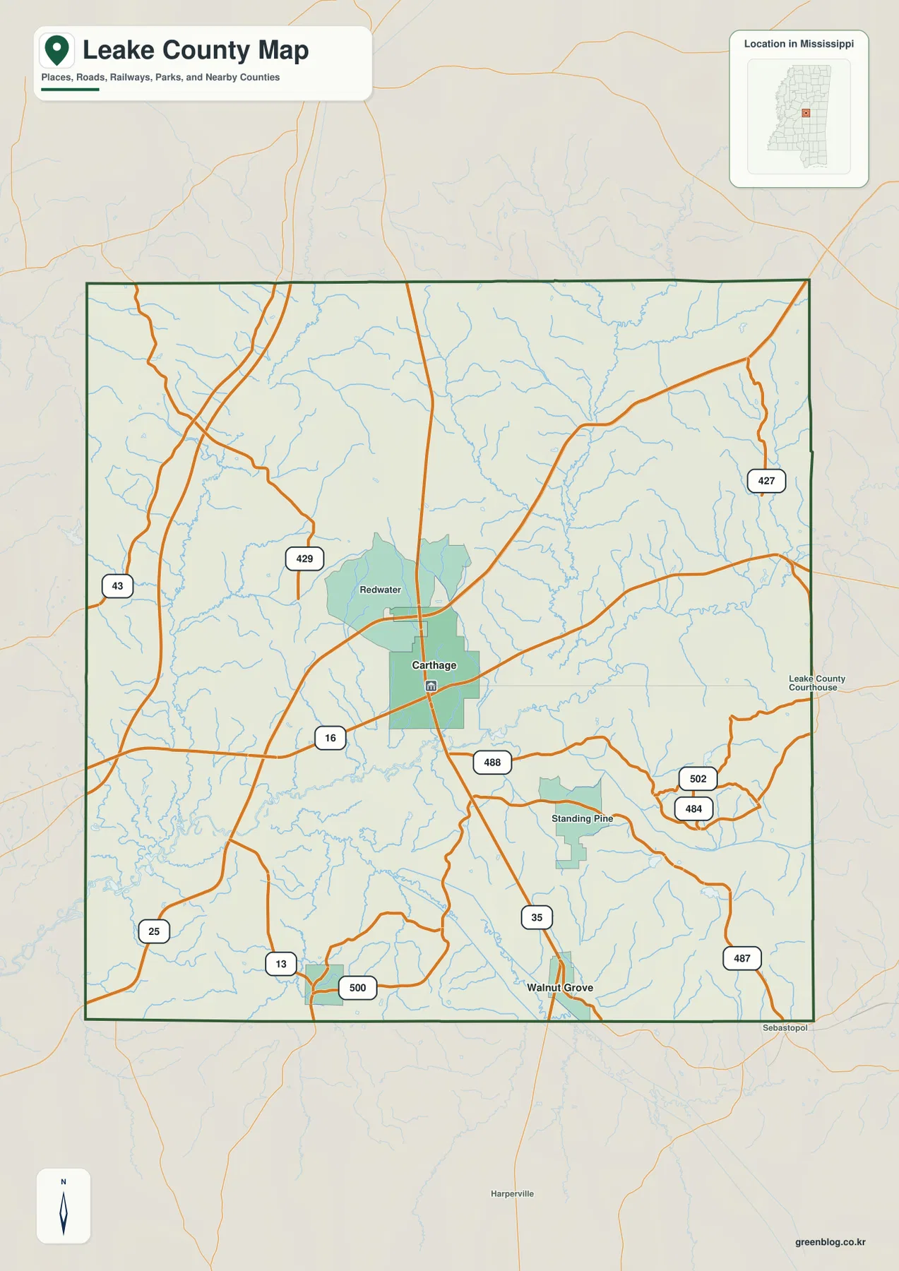
The city connection map gives a simpler picture of settlement. Carthage is ranked first at 4,866 people, Walnut Grove is shown at 737, and Lena at 169. The two smaller places are each listed as about 11 miles from Carthage in direct distance. That measurement is straight-line distance, not driving mileage, so it should be used to compare relative location rather than to estimate a road trip.
Direction matters as much as the number. Walnut Grove lies south of Carthage and is tied closely to the MS 35 corridor, while Lena is southwest of the central city. Their equal listed distance therefore does not make them part of the same travel line. The broader city map also labels Attala County to the north, Madison County to the west, Neshoba and Winston counties on the eastern side, and Scott and Newton counties along the southern and southeastern approaches. Those neighboring labels help place Leake County within central Mississippi without crowding the map with every small community.
Pearl River, Yockanookany River, and the creek valleys
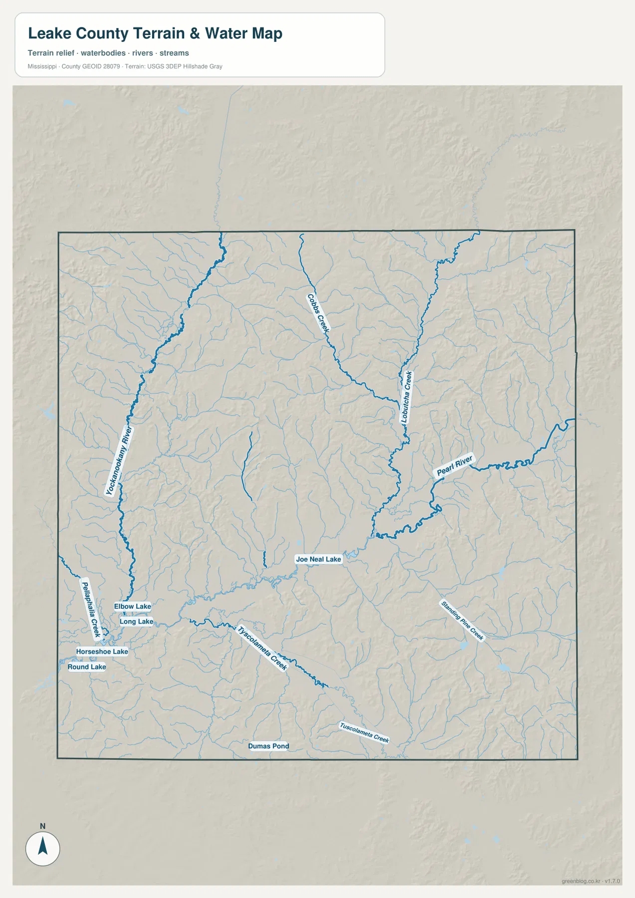
Water in Leake County is defined more by a network of rivers and creeks than by one large reservoir. The Yockanookany River is a strong north-south feature on the western side. Cobbs Creek descends through the north-central area, and Lobutcha Creek occupies a major eastern drainage line before joining the broader Pearl River system. Pearl River itself bends through the east-central part of the county and receives numerous smaller tributaries.
The southern half contains another set of useful water references. Tuscolameta Creek stretches across the lower part of the county, while Standing Pine Creek appears in the southeast. Several small lakes and ponds are labeled as well. Joe Neal Lake lies closer to the central-southern drainage area, and Elbow Lake, Long Lake, Horseshoe Lake, and Round Lake form a small cluster in the southwest. Dumas Pond is marked near the southern boundary. These smaller water bodies are not large enough to dominate the county outline, but they are helpful landmarks when matching a local place to the surrounding streams and terrain.
Rolling hills above long, lower drainage corridors
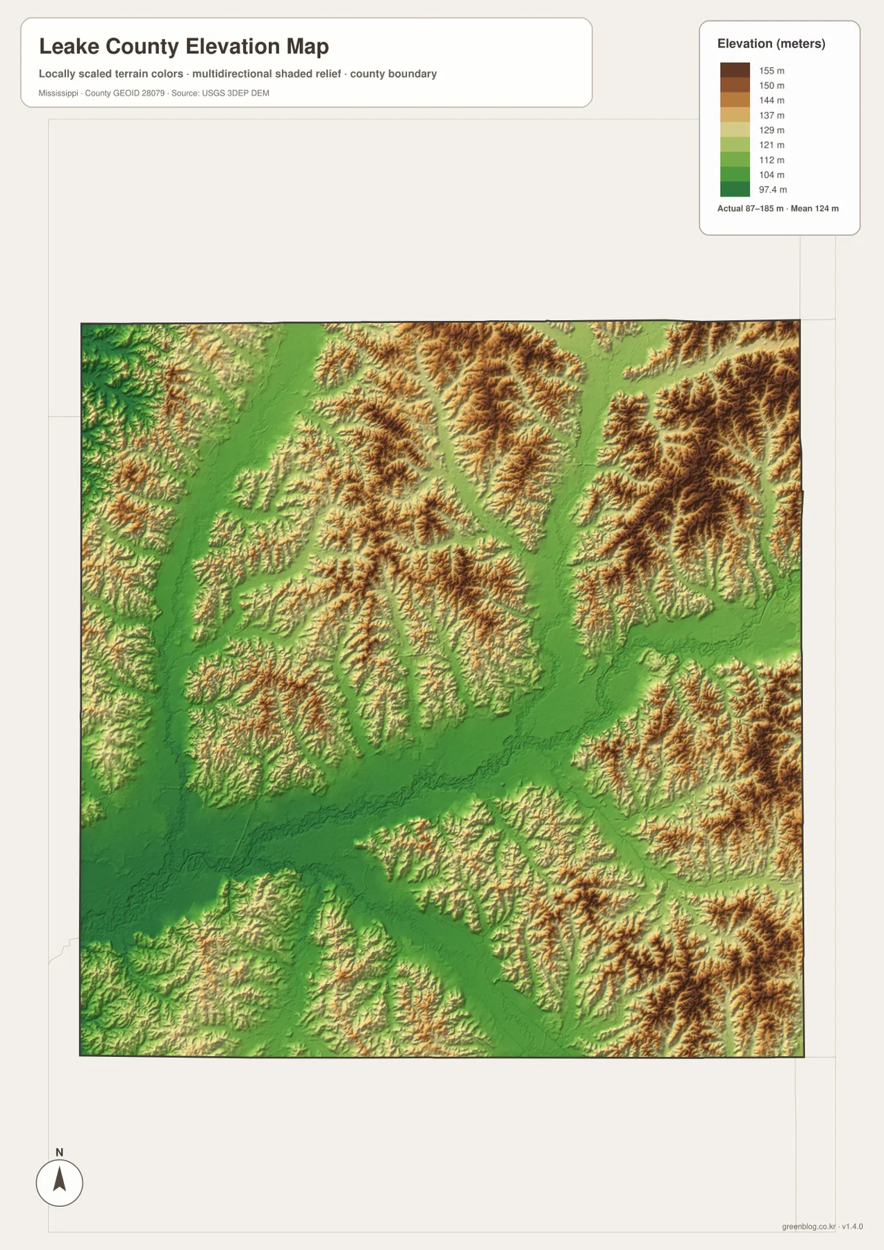
The elevation map shows an actual range of roughly 87 to 185 meters, with a mean near 124 meters. The most important feature is not the maximum elevation by itself but the repeated contrast between higher ridges and long green valleys. Brown and tan hilltops appear across much of the county, while lower ground threads between them in branching lines that closely resemble the creek network on the water map.
Broad lower corridors are especially noticeable through the central and eastern parts of the map, where drainage toward Pearl River and its tributaries creates connected low ground. The northeast and eastern margins contain repeated higher ridges, and rolling terrain also appears in the west and south. Because the colors are scaled locally, the darker high areas should be read as higher within Leake County rather than as major mountains. Comparing the elevation image with the water map is the best way to see how streams occupy the lower routes between hills.
Population and area numbers in map context
U.S. Census Bureau material in the package lists 21,275 residents in the 2020 census and a July 2025 population estimate of 21,662. Those figures come from different reference dates and should not be treated as if they were two identical census counts. The 2025 Gazetteer lists 582.897 square miles of land and 2.462 square miles of water. Dividing the 2020 population by the listed land area gives about 36.5 residents per square mile as a countywide average.
That average is useful for broad comparison, but the city map shows why it cannot describe where people actually live. Carthage is much larger than the other labeled municipalities, and settlement is not spread evenly across every hill and creek valley. The small official water-area total also deserves context. A county can have relatively little surface area classified as water while still containing many long rivers and streams, which is exactly what the water map shows here.
Which Leake County view is most useful?
For general orientation, begin with Carthage on the county map and trace MS 16 and MS 35. That immediately establishes the central road pattern and makes the directions to Walnut Grove, Lena, Redwater, and Standing Pine easier to follow. If the task is comparing communities, the city view removes most secondary detail and adds the direct-distance labels. For a river, creek, lake, or pond name, the water view is much clearer because the drainage network is emphasized instead of competing with road symbols.
The elevation map is most useful when a place name alone does not explain the landscape. It shows whether a location falls on higher rolling ground or in one of the lower drainage corridors. Opening it beside the water map makes the relationship particularly clear around Pearl River, Lobutcha Creek, Tuscolameta Creek, and the western Yockanookany River corridor. The images can therefore be used separately, but comparing two views often gives a better answer than trying to force every detail into one map.
For printing or use in a document, the downloadable archive provides the full map files rather than only the smaller WebP page previews. It contains the county, city, water, and elevation maps as high-resolution A3 JPGs. That makes it easier to print a larger copy, crop a section for a presentation, or keep the original map set together for later reference.
Frequently Asked Questions
Why is Carthage the best first reference point on the Leake County map?
Carthage sits near the central part of the county and is where several important route references come together, especially MS 16 and MS 35. Once Carthage is located, Walnut Grove to the south and Lena to the southwest are much easier to place, so it works well as the first anchor for reading both the county and city maps.
Which waterways are the easiest anchors on the Leake County water map?
Pearl River in the east-central area and Yockanookany River on the western side are the strongest first references. From there, Lobutcha Creek, Cobbs Creek, and Tuscolameta Creek help divide the interior into smaller drainage areas, while the labeled lakes and ponds provide more local landmarks.
What does the 87–185 meter elevation range mean for Leake County?
It shows that the county has noticeable local relief rather than one uniform surface. The higher colors represent rolling ridges, while the lower green corridors commonly follow rivers and creeks. The map reports a mean elevation near 124 meters, but individual valleys and ridge tops differ substantially from that average.
Map File Information
The ZIP contains the Leake County reference, city, water, and elevation maps as high-resolution A3 JPG files.
- Included Files: 4 map JPGs
- File Type: JPG
Related Maps
Sources and References
- U.S. Census Bureau QuickFacts – Leake County
- U.S. Census Bureau Gazetteer Files
- Mississippi Department of Transportation official highway map
- USGS National Hydrography
- USGS 3D Elevation Program
Green Map creates custom-edited map images using open geographic data sources such as geoBoundaries, Natural Earth, OpenStreetMap, and government open data. These maps are edited visual materials, not raw data files, and are provided for education, documents, presentations, and graphic reference.