Hancock County lies in east-central Georgia, with Sparta near the center of a broad rural landscape cut by many creeks and rolling ridges. The map set on this page separates the county into four readable themes instead of crowding every feature onto one image. The general reference map shows Sparta, Powelton, Howell Grove, Friendship, numbered roads, streams, and the county boundary. The city view emphasizes Sparta as the single ranked major city, the water map traces the Oconee River on the west and the Little Ogeechee–Ogeechee system on the east, and the elevation map shows an actual range of about 85 to 225 meters. High-resolution A3 JPG originals of all four maps are available together in the downloadable ZIP.
Sparta is the most useful starting point because it is the county seat and the clearest road reference. Routes 15, 16, and 22 meet or pass near the city, while Route 77 provides another useful reference farther northwest. Powelton lies near the northern edge, Howell Grove is northwest of Sparta, and Friendship appears in the narrow southern extension. The physical geography adds a second framework: the Oconee River forms a strong western lowland, while the Little Ogeechee River and Ogeechee River occupy the eastern side. Between them, short ridges and creek valleys give Hancock County a much more textured landscape than the simple city map suggests.
Table of Contents
Sparta, Numbered Roads, and the County Outline
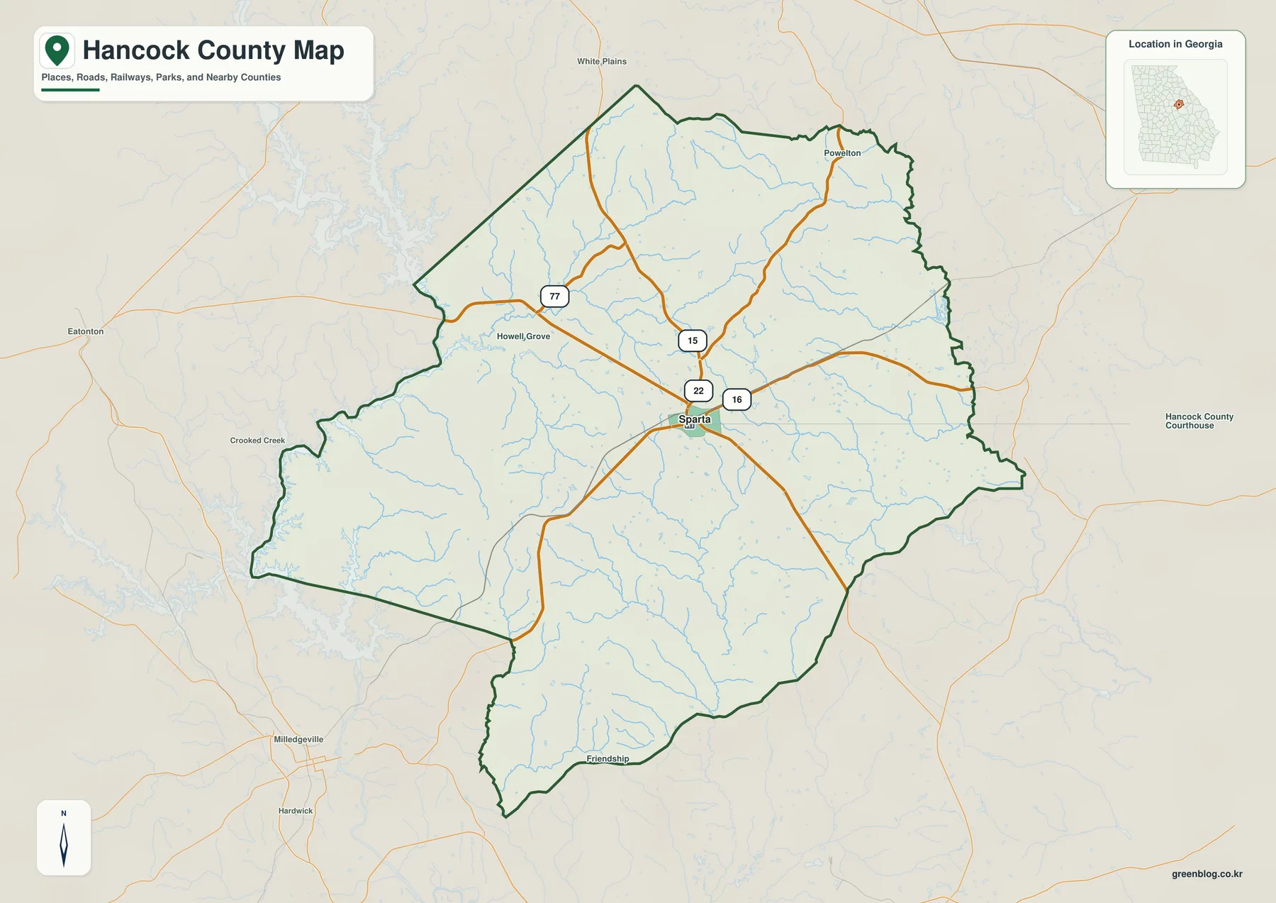
Sparta appears near the middle of the county and serves as the clearest transportation anchor on the general map. Route 15 approaches from the north, Route 22 provides a northwestern and western reference, and Route 16 continues east from the Sparta area. Route 77 is labeled farther northwest. These roads do not form a regular grid; they spread through rolling rural terrain and cross numerous small drainage lines. At county scale, their main value is directional: they show how Sparta connects with the northern, western, eastern, and southern portions of Hancock County.
The general map also labels Powelton, Howell Grove, and Friendship. Powelton sits near the northern county line, Howell Grove lies northwest of Sparta, and Friendship is placed near the bottom of the long southern extension. Outside the boundary, Eatonton and Milledgeville provide useful regional orientation. These place names are not a complete inventory of every community or local road. Their purpose is to give readers several landmarks that make the county’s broad rural spaces easier to navigate visually.
The outline itself is distinctive. The northern part is broad, the western edge bends around a major river-and-reservoir corridor, and the county narrows into a long southern section. Blue stream lines spread across nearly every part of the interior, so the open spaces between road labels are not featureless. They are divided by many small valleys. The county map provides a useful first view of that relationship, while the dedicated water map makes the drainage pattern much easier to follow.
Why the Ranked City Map Focuses on Sparta
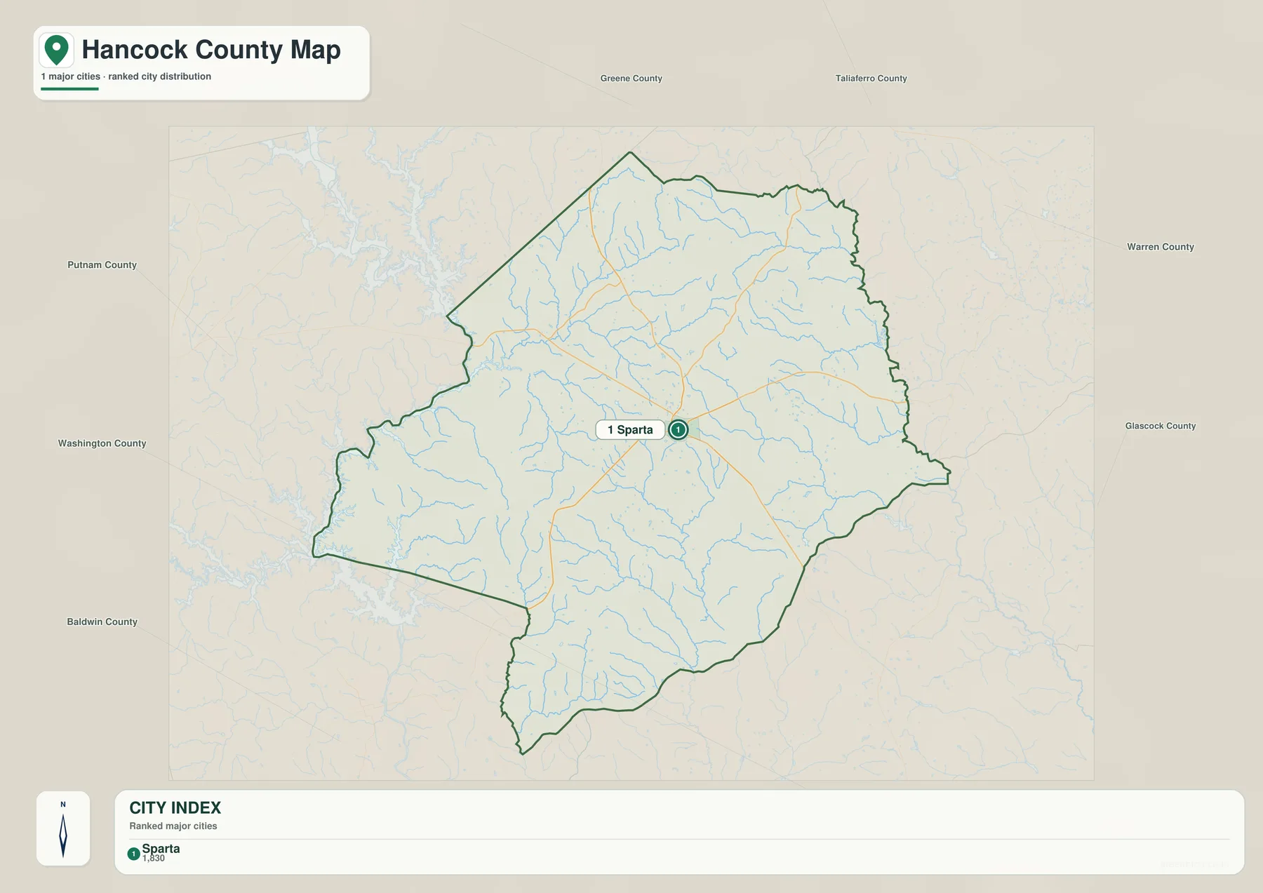
The city map is deliberately simple. Its CITY INDEX contains one ranked place: Sparta at 1,830. That number is reproduced from the supplied map to explain its ranking and should not be treated as a newly verified population estimate for this article. Current demographic figures can be checked separately through the Census QuickFacts source below. The important point here is geographic—Sparta occupies a central position and serves as the county’s main city reference.
A one-city ranking does not mean the county has no other named places. Powelton, Howell Grove, and Friendship appear on the general map, and the water map adds names such as Brown’s Lake and multiple creeks. The simplified city view removes that detail so Sparta can be located quickly. Readers who need the wider rural context should use the general county map rather than interpreting the ranked city graphic as a complete settlement list.
Neighboring county labels help place Sparta within the region. Greene and Taliaferro counties appear to the north, Warren and Glascock to the east, Washington and Baldwin to the south and southwest, and Putnam to the west. These are orientation labels rather than survey-grade boundary information. Their value is showing that Sparta sits near the center of a county surrounded by several east-central Georgia counties rather than close to one outer edge.
Oconee River Lowlands and the Ogeechee Headwaters
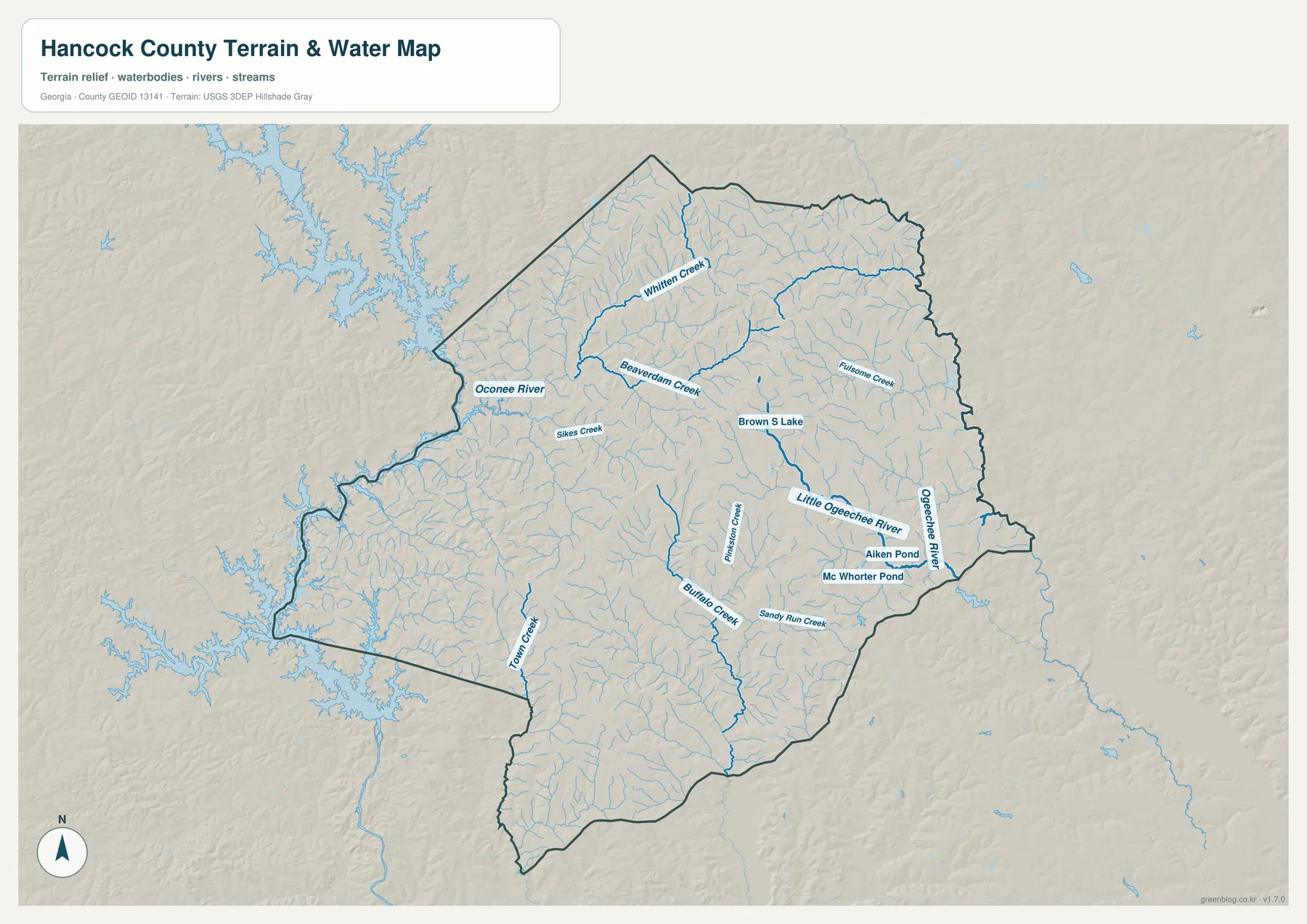
The Oconee River is the strongest large water feature on the western side of the county. It follows the boundary through a broad low corridor, with branching water surfaces spreading beyond and along parts of the western edge. The older source article in the package mentions Lake Sinclair as part of Hancock County’s modern setting, but the supplied water preview labels the Oconee River rather than the lake name. For that reason, this rewrite keeps the map description tied to what is directly visible: the Oconee corridor and the large connected water surface along the west.
The eastern half is organized by a different river system. Little Ogeechee River crosses the east-central interior, and Ogeechee River is labeled close to the eastern boundary. Whitten Creek and Beaverdam Creek provide long northern tributary references, while Fulsome Creek appears farther east. Sikes Creek is labeled on the western side and descends toward the Oconee system. Together, these names show that Hancock County is divided between western drainage toward the Oconee and eastern valleys connected with the Ogeechee system.
The central and southern sections contain another set of named channels. Pritchard Creek follows a central-southern valley, Buffalo Creek and Sandy Run Creek extend through the southeastern half, and Tower Creek runs through the southern extension. Brown’s Lake appears near the north-central interior, while Aiken Pond and Mc Whorter Pond provide small standing-water references farther southeast. Many additional tributaries are unnamed at this scale, but their density makes the county’s rolling terrain easy to recognize.
This water map is intended for county-scale geographic reference. It does not establish parcel flood status, property boundaries, water depth, or legal access. Those decisions need the appropriate current local or agency records. For ordinary map reading, the useful relationships are the Oconee River on the west, the Little Ogeechee and Ogeechee rivers on the east, and the many named creeks that occupy the lower valleys between those larger systems.
Elevation from About 85 to 225 Meters
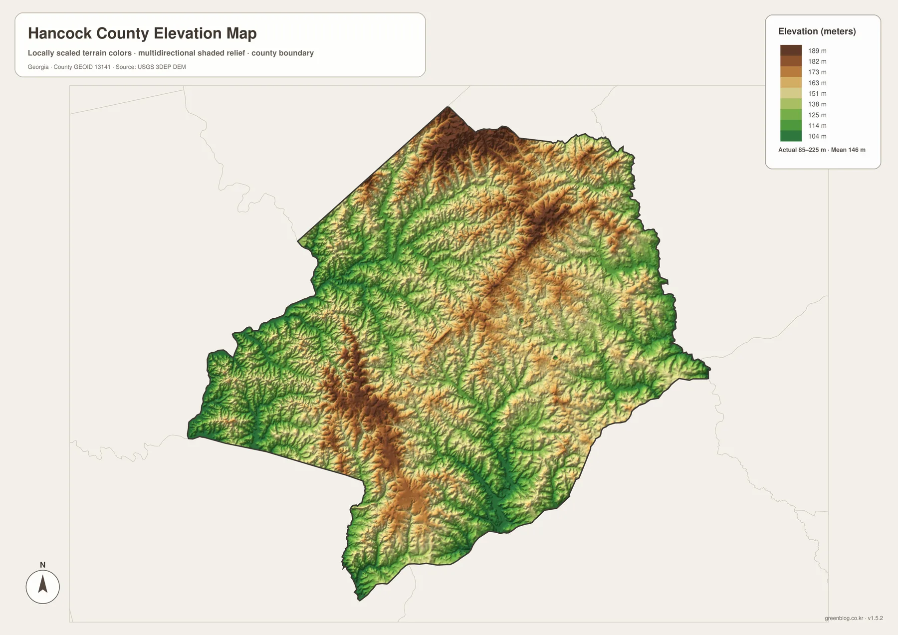
The supplied elevation map reports an actual range of approximately 85 to 225 meters, with a mean of 146 meters. Hancock County is not mountainous, but the shaded relief shows a dense pattern of short ridges and creek valleys. The broadest green lowland lies along the Oconee River on the west, while the northern edge and parts of the north-central interior rise into tan and brown higher ground. The difference of about 140 meters is enough to make river corridors and uplands clearly visible.
The northern terrain contains several higher ridge systems cut by narrow green valleys. Those valleys match the drainage pattern shown by Whitten Creek, Beaverdam Creek, and their smaller tributaries. Another band of higher ground runs through the central-eastern interior, where the Little Ogeechee River and smaller channels occupy lower corridors between ridges. The map therefore explains why the water network looks so dense: streams repeatedly follow the low paths between short rolling uplands.
The western Oconee side is the clearest lowland in the county. Green terrain follows the river corridor, then gives way to shorter ridges farther east. The southern extension also contains many low creek valleys, but a noticeable ridge rises through part of the south-central area. Hancock County is therefore better described as rolling terrain organized by many drainage valleys than as a simple flat surface or a one-direction slope.
The relief colors are designed for broad comparison, not for surveying a building lot, engineering a road, or determining an exact property elevation. Site-level work requires finer elevation data and, when appropriate, field measurements. For a geography class, report, or local reference, the 85–225 meter range is useful because it clearly shows the low Oconee corridor, higher northern and central ground, and the many smaller valleys that cross the county.
Sparta, Historic Context, and the County’s Physical Geography
The source material in the package states that Hancock County was established in 1793 and describes historic architecture, agriculture, forest land, Lake Sinclair, and population decline as parts of its modern context. The maps here do not measure farm acreage, forest percentage, architectural resources, or demographic change. Instead, they provide the geographic framework underneath those subjects: Sparta at the center, several numbered roads, the Oconee and Ogeechee drainage systems, a network of rural creeks, and rolling relief between about 85 and 225 meters.
The general map is the best starting point when Sparta, road direction, local place names, and the county outline all matter. The city view is cleaner when the only question is where Sparta sits. The water map is the strongest reference for the Oconee River, Little Ogeechee River, Ogeechee River, Whitten Creek, Beaverdam Creek, Buffalo Creek, and the smaller ponds. The elevation map then shows why those streams occupy low corridors between higher ridges.
Sparta ties the themes together. Routes 15, 16, and 22 provide the road framework around the county seat; small tributaries extend north and south from the central area; the Oconee lowland lies to the west; and the Ogeechee-side valleys occupy the east. The relief map places Sparta within rolling middle elevations rather than on the county’s highest or lowest ground. Reading those relationships together produces a much more specific picture of Hancock County than a generic rural-county description.
Frequently Asked Questions
Why does the ranked city view show only Sparta?
The supplied city map ranks Sparta as the single major city, with a displayed value of 1,830. The general map adds other local place labels such as Powelton, Howell Grove, and Friendship, so the city view should not be interpreted as a complete list of every named community.
Which waterways are easiest to identify?
The Oconee River dominates the western side, while the Little Ogeechee River and Ogeechee River are labeled in the east. Whitten Creek, Beaverdam Creek, Buffalo Creek, Sandy Run Creek, Tower Creek, Sikes Creek, Brown’s Lake, Aiken Pond, and Mc Whorter Pond provide additional references.
What elevation range is shown?
The elevation map reports an actual range of about 85 to 225 meters and a mean of 146 meters. The Oconee River corridor is among the lowest areas, while higher ridges are strongest across parts of the north and central interior.
What is inside the A3 download package?
The archive provides four large JPG originals covering the general county reference, Sparta city map, water network, and elevation. Roads, settlement, water, and relief remain in separate files so each subject is easier to read when printed or placed in a document.
Map File Information
Hancock County A3 Map Files
- Included Files: 4 high-resolution A3 JPG map files shown in this article
- File Type: JPG files in a ZIP archive
- Intended Use: Printing, education, presentations, and map-based projects
Related Maps
Hancock County Data and Reference Sources
- U.S. Census Bureau QuickFacts: Hancock County – current official county statistics
- Hancock County official profile – county administration and local background
- New Georgia Encyclopedia: Hancock County – county history and the 1793 establishment date
- Census TIGER/Line boundary resources – Hancock County and neighboring-county reference geometry
- USGS hydrography resources – reference data for the Oconee and Ogeechee systems, creeks, lakes, and ponds
- USGS 3DEP elevation resources – source elevation data for comparing the 85–225 meter terrain range
Green Map creates custom-edited map images using open geographic data sources such as geoBoundaries, Natural Earth, OpenStreetMap, and government open data. These maps are edited visual materials, not raw data files, and are provided for education, documents, presentations, and graphic reference.