Hall County sits in northeastern Georgia with Gainesville as its main urban and administrative center, Lake Sidney Lanier occupying much of the western and southwestern landscape, and higher rolling terrain rising across the north. The maps on this page separate those features so they remain readable. The general county view shows Gainesville, Oakwood, Flowery Branch, Buford, Braselton, Clermont, Lula, Gillsville, numbered roads, and the boundary. The city map ranks six major cities, the water map traces Lake Lanier together with the Chattahoochee, Little River forks, North Oconee River, and smaller creeks, and the elevation view reports an actual range of about 223 to 660 meters. All four high-resolution A3 JPG originals are available together in the downloadable ZIP.
Gainesville is the best starting point for reading Hall County. The city lies slightly west of the county’s center, with Oakwood and Flowery Branch continuing south, Clermont to the north, and Lula and Gillsville toward the east. Yet roads and cities tell only part of the story. Lake Lanier sends long branching arms into the Gainesville and southern urban area, while West Fork Little River, East Fork Little River, and other streams descend from the higher northern hills. On the eastern side, the North Oconee River and its tributaries form a separate water framework. Comparing these features with the elevation map makes the county’s north-to-south and west-to-east contrasts much easier to understand.
Table of Contents
Gainesville and the County’s Main Road Connections
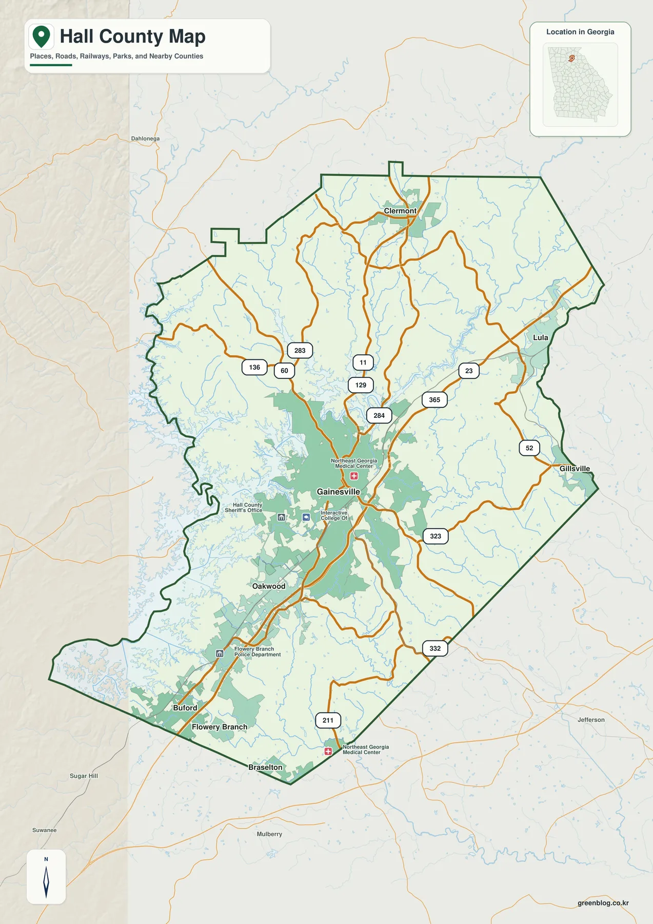
Gainesville receives the strongest visual emphasis on the general map because it is the largest developed area and the county seat. Northeast Georgia Medical Center, the Hall County Sheriff’s Office, and Interactive College of Technology are labeled nearby, providing useful orientation within the urban area. Routes 129 and 11 help establish a north-south reference through Gainesville, while Route 284 branches across the northeastern side. Routes 23 and 365 form another strong corridor east of the city and continue toward Lula. In the northwestern half, Routes 60, 136, and 283 provide additional road references, while Routes 52, 323, 332, and 211 appear across the eastern and southern portions.
The southern part of the map contains the densest sequence of developed places. Oakwood sits immediately below Gainesville, and Flowery Branch appears farther south near the reservoir shoreline. Buford and Braselton provide additional place references near the county’s lower edge, where roads continue toward neighboring metropolitan counties. A Flowery Branch police label and another Northeast Georgia Medical Center marker help locate the southern corridor. The combination of city shading and roads gives this part of Hall County a much more urban appearance than the broader northern uplands.
North of Gainesville, Clermont stands out as the clearest city reference. Roads spread through increasingly hilly terrain, and developed areas become smaller and farther apart. Lula occupies the northeastern side near the 23/365 corridor, while Gillsville appears farther southeast near Route 52. The county map is useful at this scale because it shows the broad direction of those communities relative to Gainesville and Lake Lanier. It is not meant to replace current street navigation or show every local road and subdivision.
Six Ranked Cities from Gainesville to Rest Haven
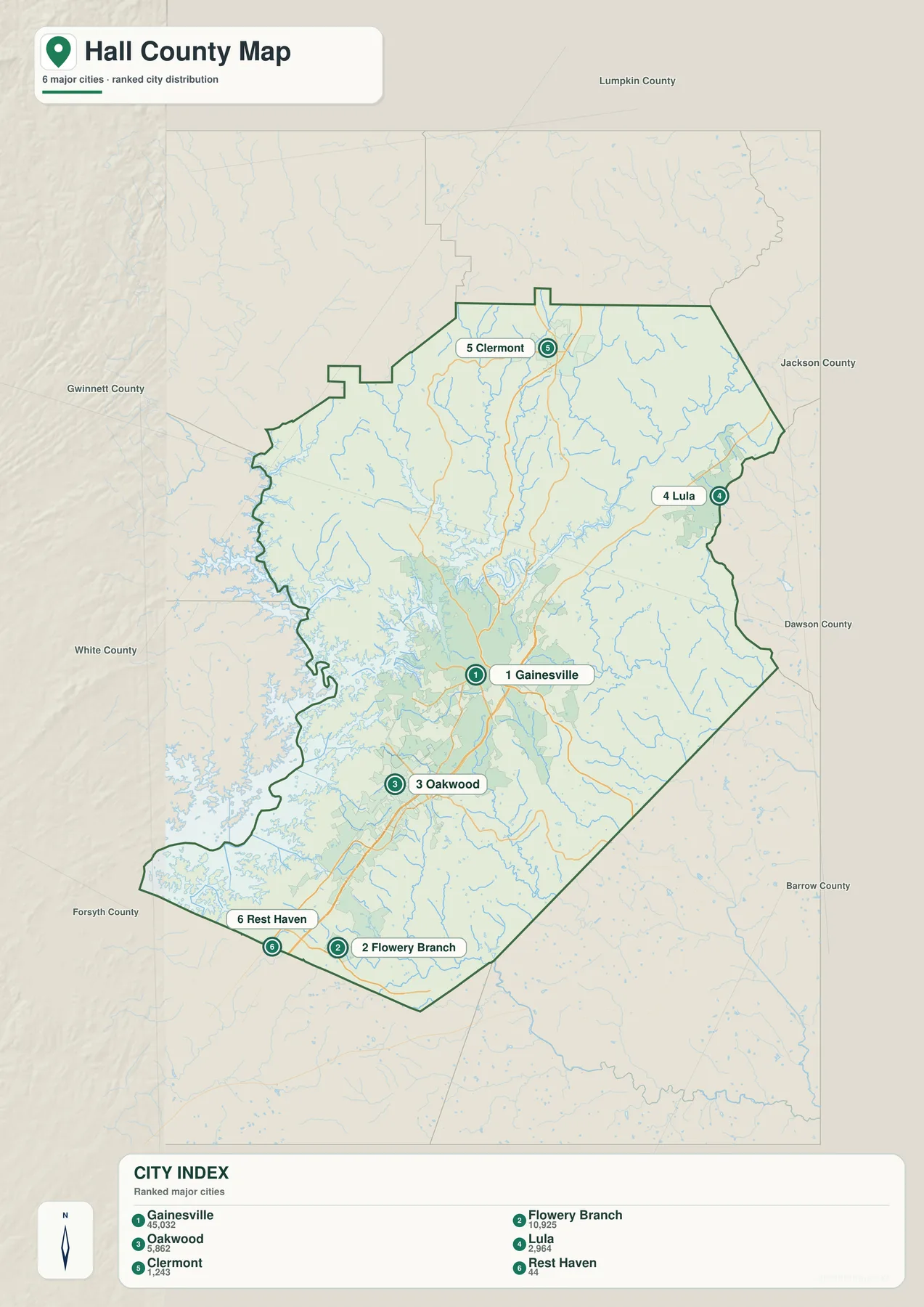
The city map removes most road and landmark detail and focuses on six ranked cities. Gainesville carries the largest displayed value at 45,032, followed by Flowery Branch at 10,925. Oakwood is shown at 5,862 and Lula at 2,964. Clermont appears at 1,243, while Rest Haven is listed at 44. These are the values printed on the supplied map and are included here to explain the graphic’s ranking. They are not newly calculated population estimates; readers who need current official demographic figures can use the Census QuickFacts source in the reference section.
The distribution itself is more useful than the numbers alone. Gainesville occupies the central-western urban core, while Oakwood and Flowery Branch form a clear southern sequence. Clermont is separated to the north, and Lula sits to the northeast. Rest Haven appears near the southwestern side and is much smaller on the map. This arrangement shows that the county’s major city labels do not form one compact cluster even though Gainesville clearly dominates the center.
The general county map includes additional place names that do not appear in the six-city ranking, including Buford, Braselton, and Gillsville. For that reason, the city view should not be read as a complete municipal inventory. Its purpose is narrower: it provides a clean comparison of the six major ranked cities. The general map adds more local context, while the water and elevation maps explain why urban growth, lake shoreline, and higher terrain occupy different parts of Hall County.
| Map rank | City | Displayed value | General position |
|---|---|---|---|
| 1 | Gainesville | 45,032 | central-western urban core |
| 2 | Flowery Branch | 10,925 | southwest near Lake Lanier |
| 3 | Oakwood | 5,862 | south of Gainesville |
| 4 | Lula | 2,964 | northeastern side |
| 5 | Clermont | 1,243 | north |
| 6 | Rest Haven | 44 | southwestern side |
Lake Sidney Lanier, Little River Forks, and the North Oconee
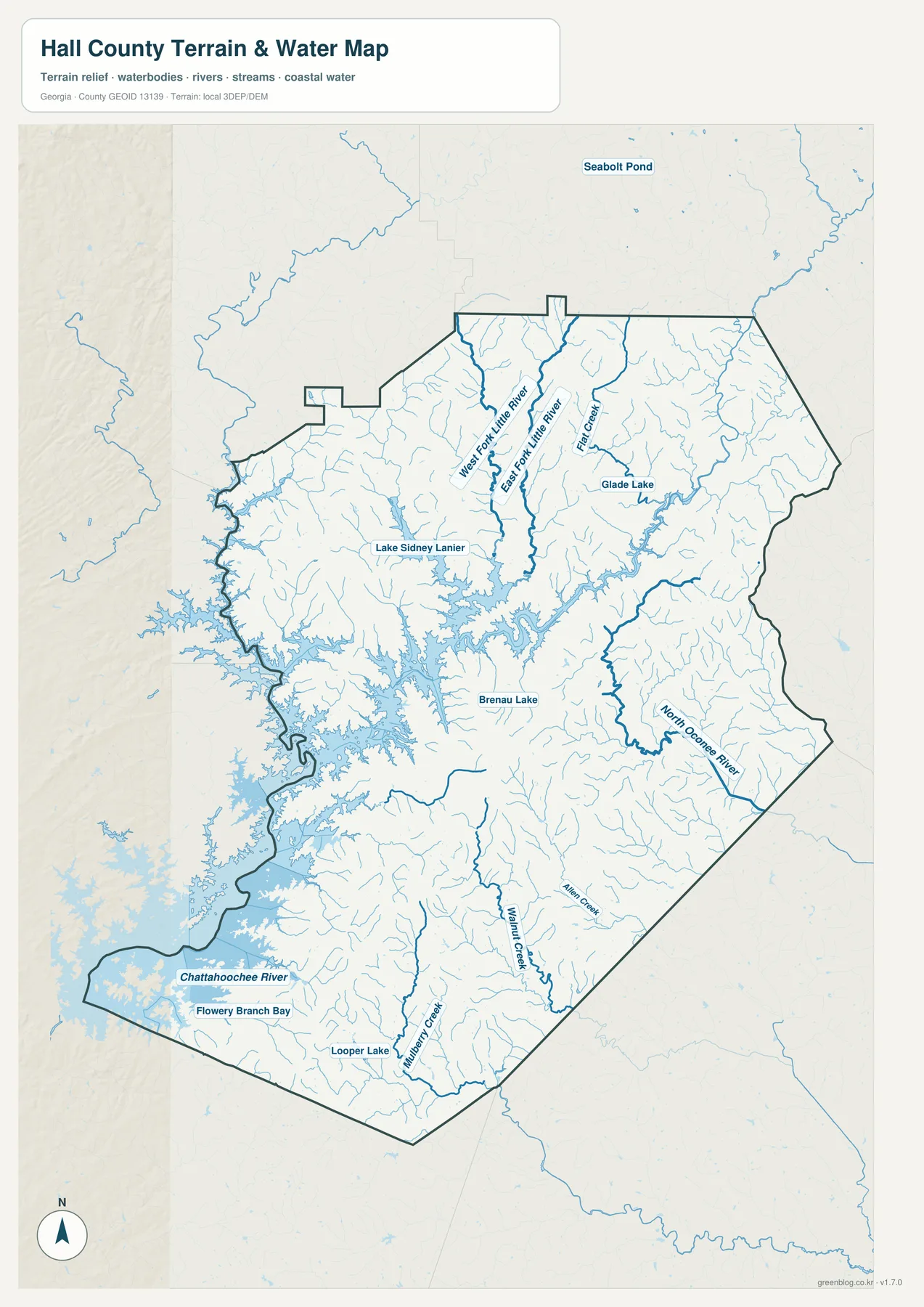
Lake Sidney Lanier dominates the western and southwestern water map. The shoreline is highly branched, with long reservoir arms extending into the county near Gainesville, Oakwood, and Flowery Branch. The Chattahoochee River is labeled at the southwestern end, and Flowery Branch Bay provides a local reference along the southern water edge. This shape helps explain why the western county boundary and road pattern look so irregular on the general map: large areas of land are separated by narrow reservoir coves rather than by a simple straight shoreline.
The north contains a different set of water features. West Fork Little River and East Fork Little River run through valleys descending from the higher northern terrain, with Flat Creek providing another strong named stream nearby. Glade Lake appears as a smaller reference in the northeast. Numerous unnamed tributaries join these channels or flow toward the reservoir. The density of blue lines shows that Hall County’s northern hills are deeply divided by drainage valleys even where urban development is sparse.
East of the main reservoir system, the North Oconee River follows a long corridor through the eastern-central county. Allen Creek and Walnut Creek are labeled farther south, while Mulberry Creek and Looper Lake appear closer to the southern boundary. Brenau Lake is marked south of Gainesville. These names are important because they show that not every stream in Hall County drains directly into Lake Lanier. The eastern and southern parts contain separate river and creek corridors that create their own low valleys.
This water map is designed for county-scale geographic orientation. Flood status for a specific property, shoreline ownership, boat access, channel depth, or reservoir operating conditions require current specialized sources. For map reading, the useful relationships are the reservoir arms around Gainesville and Flowery Branch, the Little River forks descending from the north, the Chattahoochee connection in the southwest, and the North Oconee system on the eastern side.
Elevation from About 223 to 660 Meters
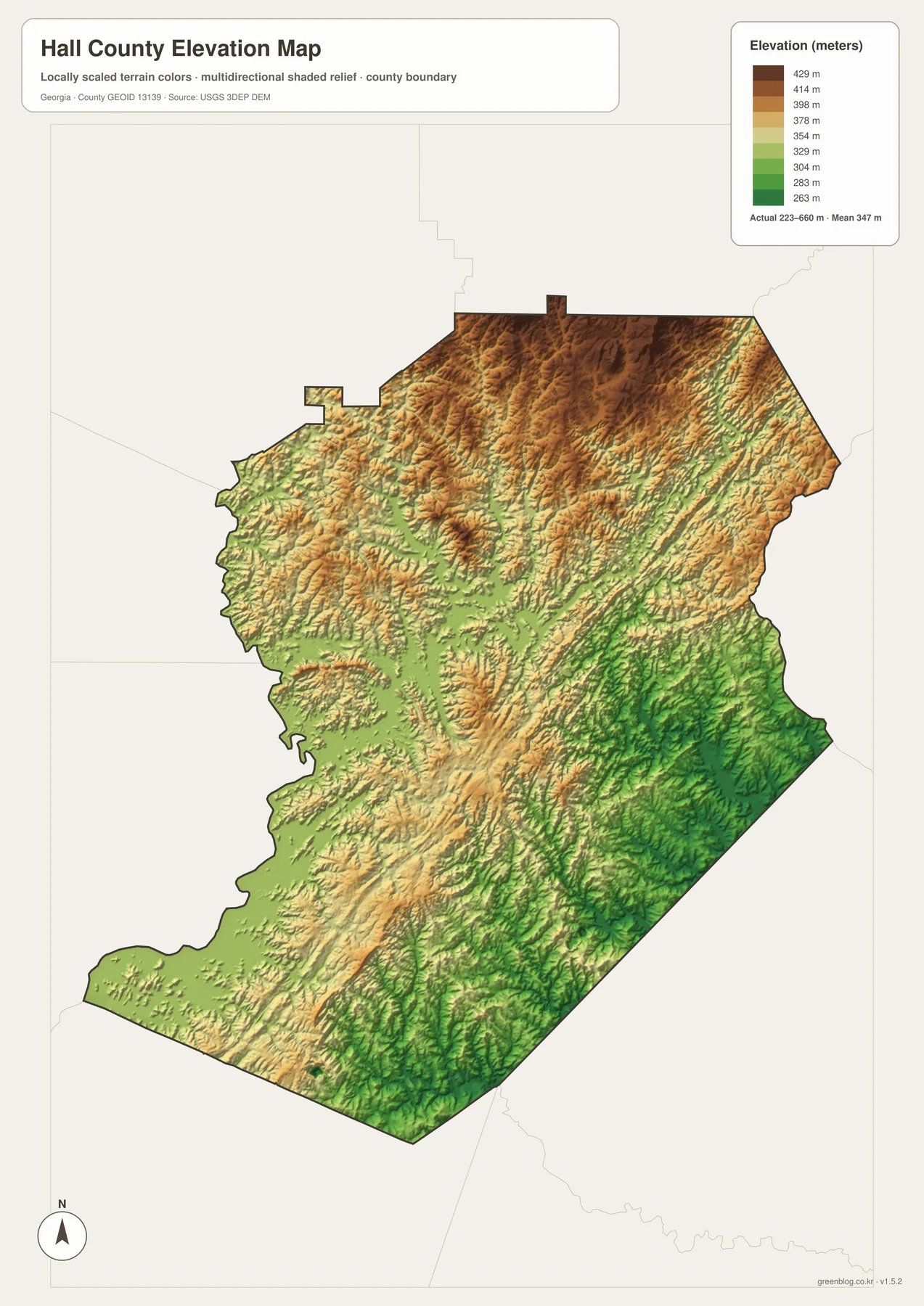
The supplied elevation map reports an actual range of approximately 223 to 660 meters, with a mean of 347 meters. The northern half is dominated by tan and brown rolling relief, with especially strong ridges across the northwest and north-central areas. Elevation drops toward Gainesville and becomes lower again around the Lake Lanier shoreline in the west and southwest. A difference of more than 400 meters between the lowest and highest mapped terrain gives Hall County a strong north-to-south contrast.
The northern river valleys are easy to match with the relief map. West Fork Little River, East Fork Little River, and Flat Creek occupy lower green corridors between the higher ridges. Those valleys descend toward the broader Lake Lanier lowlands. This relationship makes the water network easier to understand: streams follow the lower paths through the terrain and eventually reach the reservoir or larger river system rather than cutting directly across the highest ground.
The eastern and southeastern sections remain rolling even though they are generally lower than the strongest northern ridges. Around Lula and Gillsville, short hills alternate with narrow creek valleys. The North Oconee River, Allen Creek, and Walnut Creek occupy some of the lower corridors. The southern Braselton side is also not completely flat; gentle ridges continue across the lower landscape. The elevation view therefore shows a gradual transition rather than a sharp boundary between mountains and plain.
The relief colors are intended for broad comparison across Hall County. They do not provide survey-grade elevation for a building lot, road project, drainage design, or construction plan. Those tasks require finer elevation data and, when appropriate, field measurements. For a geography lesson, county profile, or presentation, the 223–660 meter range is useful because it clearly separates the higher northern hills from lower reservoir and stream valleys.
Reading Gainesville, Lake Lanier, and the Northern Uplands Together
The source material in the package identifies Hall County as established in 1818 and Gainesville as the county seat. It also describes Lake Lanier, transportation routes, medical and educational institutions, and regional growth as important parts of the county’s modern setting. The four maps here do not attempt to measure economic growth or institutional reach. Instead, they provide the geographic framework beneath those subjects: Gainesville at the urban center, a dense southern city corridor, a major reservoir to the west, separate river systems to the east, and higher terrain across the north.
The general map is the best starting point when places, numbered roads, and county position all matter. The ranked city view is cleaner for comparing Gainesville, Flowery Branch, Oakwood, Lula, Clermont, and Rest Haven. The water map becomes the better reference when the question concerns Lake Lanier, the Chattahoochee River, Little River forks, or the North Oconee system. The elevation map then explains why the northern part is more strongly ridged and why so many water corridors converge toward lower areas.
Gainesville ties the themes together especially well. Roads radiate toward the north, east, and southern urban corridor; Lake Lanier reaches close to the city’s western side; Oakwood and Flowery Branch continue toward the reservoir-influenced south; and the land rises toward Clermont and the northern hills. Looking at those relationships together gives a more complete picture of Hall County than a city list or road map alone.
Frequently Asked Questions
Which six cities are ranked on the city map?
The supplied city view ranks Gainesville, Flowery Branch, Oakwood, Lula, Clermont, and Rest Haven. The general county map also labels additional places such as Buford, Braselton, and Gillsville.
What waterways can be identified besides Lake Lanier?
The map labels the Chattahoochee River, West Fork Little River, East Fork Little River, Flat Creek, North Oconee River, Allen Creek, Walnut Creek, and Mulberry Creek. Glade Lake, Brenau Lake, Looper Lake, and Flowery Branch Bay also provide useful local water references.
What elevation range is shown for Hall County?
The elevation map reports an actual range of about 223 to 660 meters and a mean of 347 meters. The strongest high relief is concentrated in the northern half, while Lake Lanier and major stream valleys occupy lower terrain.
What does the A3 map archive contain?
The archive provides four large JPG originals covering the general county reference, ranked-city distribution, water network, and elevation. Each file keeps a different subject readable while using the same Hall County boundary.
Map File Information
Hall County A3 Map Files
- Included Files: 4 high-resolution A3 JPG map files shown in this article
- File Type: JPG files in a ZIP archive
- Intended Use: Printing, education, presentations, and map-based projects
Related Maps
Hall County Data and Reference Sources
- U.S. Census Bureau QuickFacts: Hall County – current official county statistics
- New Georgia Encyclopedia: Hall County – county history and regional background
- New Georgia Encyclopedia: Gainesville – local background on Gainesville
- Census TIGER/Line boundary resources – Hall County and neighboring-county reference geometry
- USGS hydrography resources – reference data for Lake Lanier, rivers, creeks, and other mapped waters
- USGS 3DEP elevation resources – source elevation data for comparing the 223–660 meter terrain range
Green Map creates custom-edited map images using open geographic data sources such as geoBoundaries, Natural Earth, OpenStreetMap, and government open data. These maps are edited visual materials, not raw data files, and are provided for education, documents, presentations, and graphic reference.