Labette County occupies the southeastern corner of Kansas along the Oklahoma border, and its geography is easiest to understand from two different centers. Parsons is the largest city and the main northern urban hub, while Oswego is the county seat near the Neosho River. Altamont, Chetopa, Mound Valley, and Edna provide smaller references across the rural interior. U.S. 400, U.S. 160, U.S. 59, and several state highways connect these communities. High-resolution JPG versions of the maps can be downloaded together from the ZIP box below. High-resolution map files are available for download in the section below.
The eastern side is defined by the Neosho River, which follows a broad low corridor near the county boundary. Little Labette Creek crosses the north, Labette Creek drains much of the central and southeastern county, and Big Hill Creek, Pumpkin Creek, Deer Creek, and other streams dissect higher western terrain. Elevation ranges from about 217 to 320 meters with a mean near 266 meters, producing a clear contrast between western hills and the lower Neosho River valley.
The Kansas Historical Society records that Labette County was established in 1867 and identifies Oswego as the county seat. Parsons developed later around the Missouri-Kansas-Texas Railroad and was named for railroad president Levi Parsons. The modern map preserves that division of roles: Parsons is by far the largest city, while Oswego remains the administrative center.
Table of Contents
Parsons and Oswego provide two different county anchors
Parsons sits in the northern part of the county and is the strongest urban reference on the general map. U.S. 400 runs east-west through the area, linking the city with surrounding southeastern Kansas. Oswego lies farther south and east near the Neosho River and contains the county courthouse and administrative offices.
U.S. 160 crosses the middle of the county from the Mound Valley side through Altamont toward Oswego. U.S. 59 follows the eastern corridor through the Oswego and Chetopa side, while K-101 provides a north-south connection from the Altamont area toward Edna. The southern road network becomes more rural around Bartlett, Edna, and Chetopa.
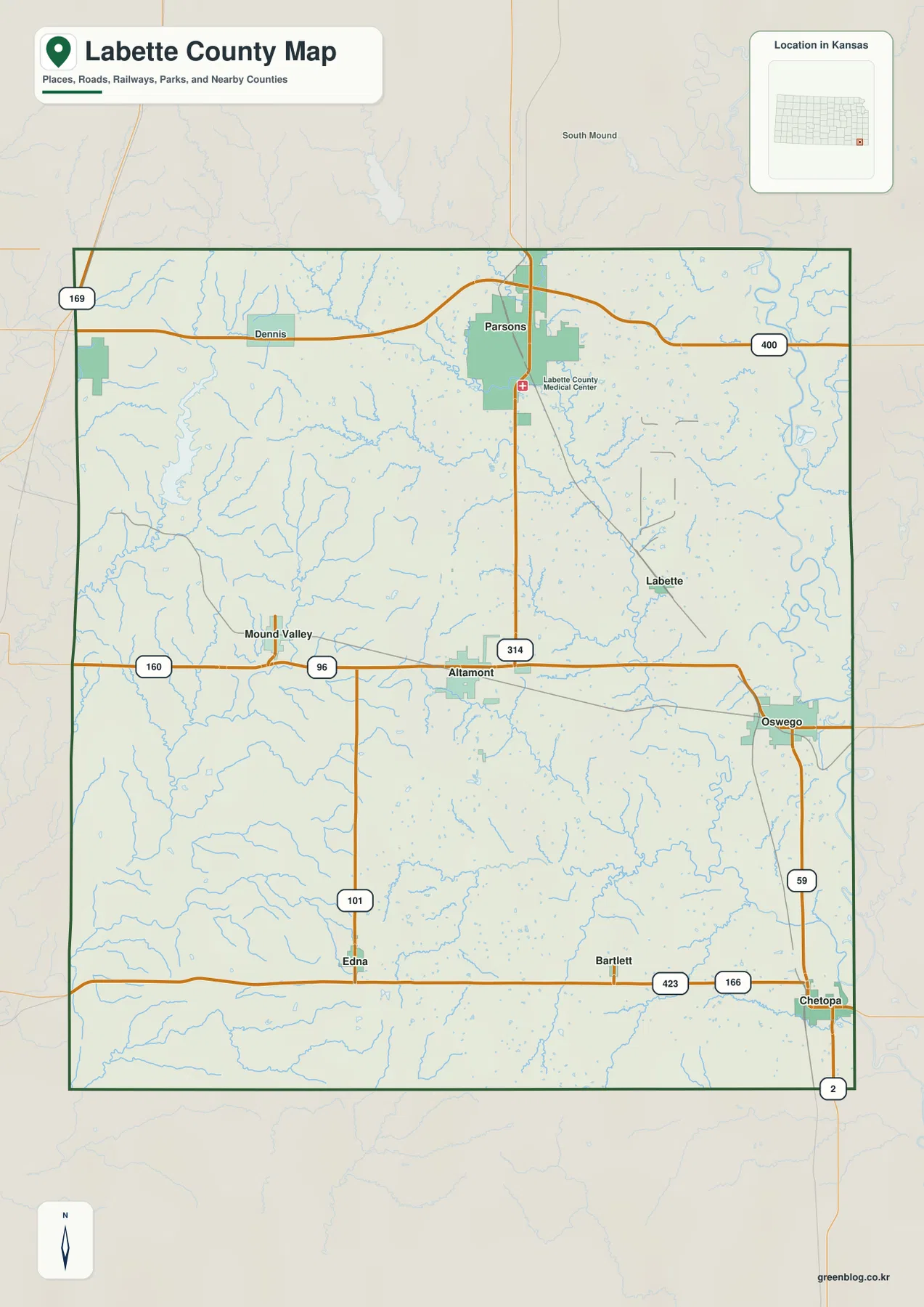
Western Labette County has a more regular rural road grid, but eastern roads repeatedly cross river and creek valleys. Parsons contains a denser urban pattern, while the Oswego and Chetopa side is shaped more directly by the Neosho River lowlands. This map is intended for county-scale orientation rather than live navigation, so construction, flooding, and unpaved-road conditions should be checked separately.
Parsons is largest, while Oswego holds the county-seat role
The city distribution map ranks Parsons first, Oswego second, Altamont third, Chetopa fourth, Mound Valley fifth, and Edna sixth. The displayed source values are 9,425 for Parsons, 1,937 for Oswego, 993 for Altamont, 977 for Chetopa, 341 for Mound Valley, and 297 for Edna. These values may differ from later estimates, but the settlement hierarchy is clear.
Parsons is the dominant population, commercial, medical, and educational center, while Oswego serves the county government role. Altamont and Mound Valley help organize the central and western rural areas, and Chetopa and Edna provide southern references near the Oklahoma border.
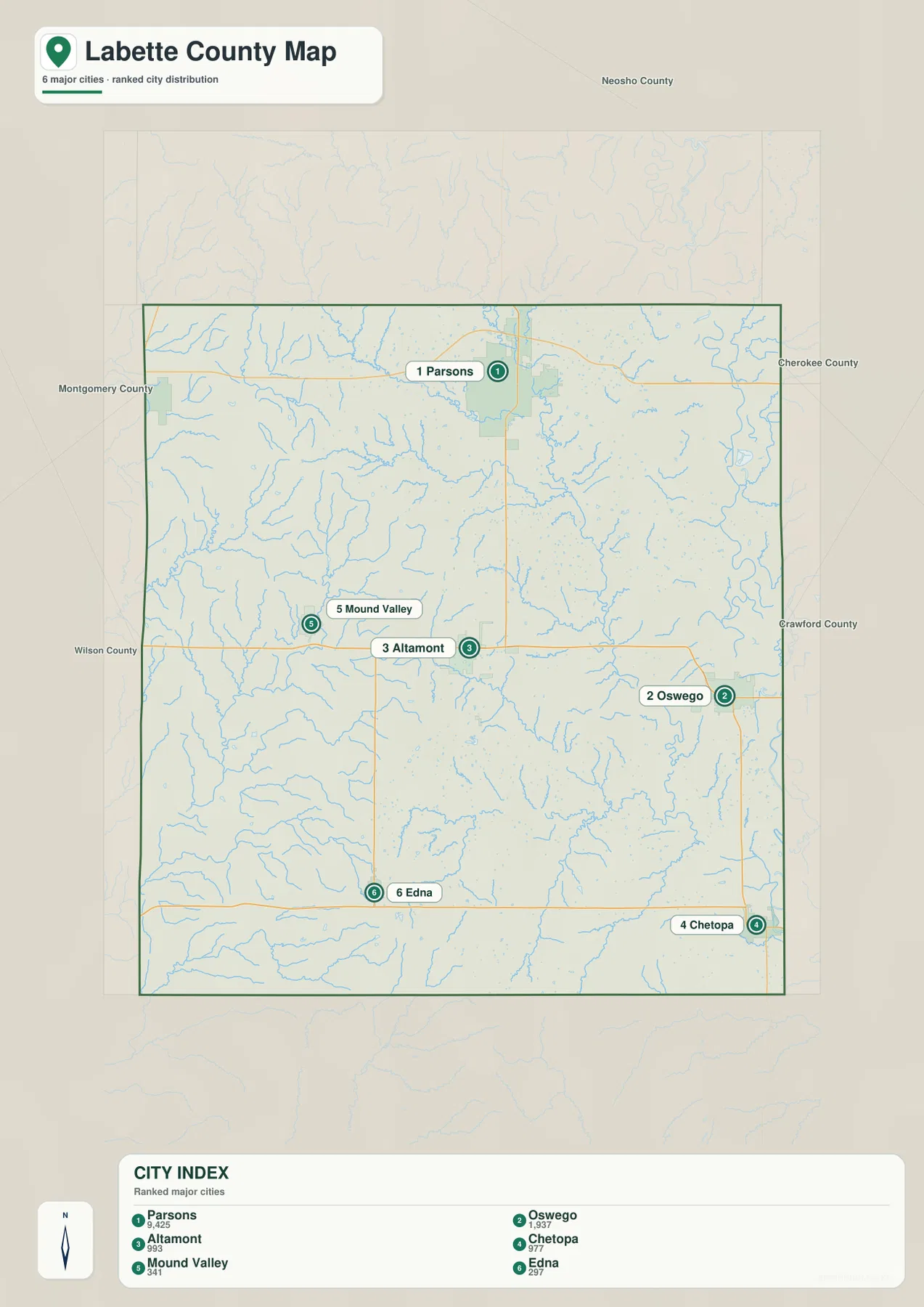
The official Labette County website makes the same distinction, listing Oswego as the county seat and Parsons as the most populous city. That separation is important when reading the map because population size and administrative function are concentrated in different places.
The Neosho River forms the broadest lowland
The Neosho River is the largest and most continuous water feature on the terrain map. It follows the eastern side of the county in broad bends and occupies some of the lowest land shown on the elevation surface. Oswego and Chetopa sit close to this river corridor, giving them a different physical setting from the higher western communities.
Little Labette Creek crosses the northern part of the county, while Bachelor Creek and many short tributaries cut the surrounding hills. Labette Creek extends through the central and southeastern area and is joined by smaller streams such as Hackberry Creek, Lake Creek, and Turkey Creek before the drainage reaches the Neosho lowlands.
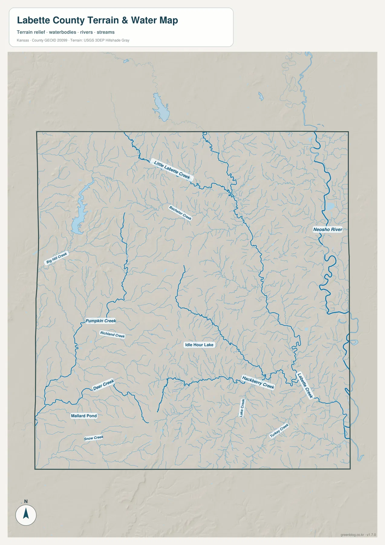
Big Hill Creek, Pumpkin Creek, Richland Creek, and Deer Creek dissect the higher western side. Idle Hour Lake provides a central water reference, while Mallard Pond and Snow Creek appear in the southwest. The map shows geographic location rather than current streamflow, flood risk, or water quality, so live conditions should be checked through USGS or responsible local agencies.
Relief ranges from 320-meter western hills to 217-meter river bottoms
Labette County ranges from approximately 217 to 320 meters in elevation and averages near 266 meters. Brown and orange colors cover the higher west and northwest, with additional ridges through the south-central county. The lowest dark-green terrain follows the Neosho River along the eastern edge.
Short western creeks carve narrow valleys into the uplands, creating a surprisingly rugged texture for a county with many straight rural roads. Moving east, the surface generally drops through tan and yellow-green terrain before reaching the broad Neosho River lowland. Labette Creek and its tributaries create additional green corridors through the central and southeastern county.
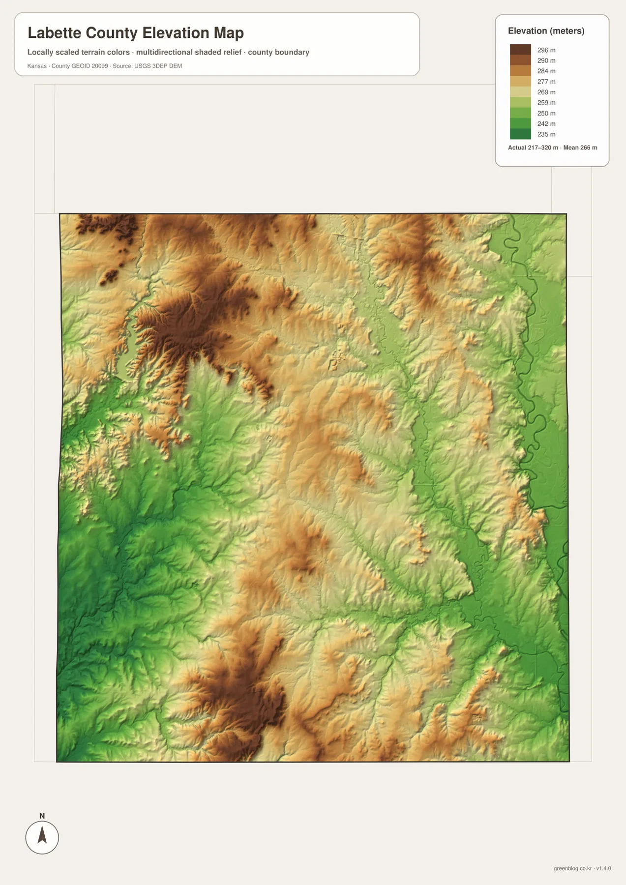
This elevation surface is intended for county-scale comparison rather than survey-grade measurement. It should not be used to establish exact parcel elevations, design drainage, or replace engineering and legal survey data. Its main value is showing the strong difference between the western uplands and the low river corridor near Oswego and Chetopa.
Parsons grew where the railroad branches met
Parsons was founded in 1871 at a meeting point of the Missouri-Kansas-Texas Railroad, commonly known as the MKT or Katy. The City of Parsons explains that the community was named for railroad president Levi Parsons. Rail transportation and agriculture gave the new town a strong economic base and helped it grow rapidly.
The city later added educational, medical, and industrial functions. Parsons’ official history notes the establishment of a business college and state hospital around the turn of the twentieth century and the Kansas Ordnance Plant during World War II. Those developments helped Parsons maintain a larger urban role than other communities in Labette County.
The modern road map reflects that long concentration of activity. Parsons has the county’s largest built-up area and serves as a major northern service center even though county government remains in Oswego. The two-city pattern is therefore a product of different historical functions rather than a simple population ranking.
Oswego, the Neosho River bluff, and the county name
Oswego sits on higher ground overlooking the Neosho River Valley. The city’s official website describes it as the Labette County seat at the U.S. 59 and U.S. 160 intersection and notes the bluff above the river valley. That setting is visible on the elevation map, where the city stands just west of the much lower river corridor.
The origin of the Labette name has more than one surviving explanation. The Kansas Historical Society records a tradition linking it to the French phrase ‘la bête,’ meaning ‘the beast,’ but also notes another account that connects the name to Pierre Bete, a French-Canadian trader who lived along the Neosho River and had ties to the Osage people.
The region had a long Indigenous and trading history before modern county boundaries were established. The Neosho River was an important natural corridor well before highways and railroads. Reading the river, bluff, and city maps together provides a useful way to connect those older landscapes with present-day Labette County.
Using the maps for printing, study, and county orientation
For road orientation, begin with Parsons and Oswego, then use U.S. 400, U.S. 160, and U.S. 59 to place Altamont, Mound Valley, and Chetopa. For physical geography, start with the Neosho River on the east, trace Little Labette Creek and Labette Creek, and then compare Big Hill Creek, Pumpkin Creek, and Deer Creek across the higher western side.
The high-resolution JPG files in the ZIP are better suited than the reduced web previews for printing, classroom projects, railroad and county-seat history, and close inspection of road and water labels. Current road conditions, live stream information, parcel boundaries, and exact elevations should always be checked against the latest authoritative sources when those details matter.
Frequently Asked Questions
Is Parsons or Oswego the county seat?
Oswego is the county seat, while Parsons is the largest city in Labette County. Parsons functions as the principal northern population and service center, and Oswego contains the county courthouse and government offices.
Where are the Neosho River and Labette Creek?
The Neosho River follows the eastern side of the county and creates the broadest lowland. Labette Creek drains much of the central and southeastern county toward that river, while Little Labette Creek crosses the northern area east of Parsons.
Can the 217–320 meter elevation map be used for surveying?
No. The elevation map is a county-scale visual reference for comparing uplands and river valleys. Exact parcel elevations, construction design, drainage engineering, and legal surveys require purpose-built data and professional methods.
Map File Information
Download the high-resolution JPG files corresponding to the Labette County general, city distribution, terrain-and-water, and elevation maps in one ZIP archive.
- Included Files: Use only the versions confirmed in the article and supplied images
- File Type: Use the confirmed download contents
- Intended Use: Printing, education, presentations, and map-based projects
Related Maps
Sources and references
- Labette County, Kansas official website — Oswego county seat and county government information
- Kansas Historical Society — Labette County, Kansas — establishment, county seat, name origin, and population history
- City of Parsons — Community Profile — railroad founding and local history
- City of Oswego — Welcome — county-seat location and Neosho River Valley setting
- USGS National Hydrography — hydrography and stream-network data information
- USGS 3D Elevation Program — elevation data information
Green Map creates custom-edited map images using open geographic data sources such as geoBoundaries, Natural Earth, OpenStreetMap, and government open data.
These maps are edited visual materials, not raw data files, and are provided for education, documents, presentations, and graphic reference.